
Gjønakvitingen from Gjøn (via Selfjellet) (17.08.2025)

Written by HHauser (Helwig Hauser)

| Start point | Gjøn (55m) |
|---|---|
| Endpoint | Gjøn (55m) |
| Characteristic | Hike |
| Duration | 8h 00min |
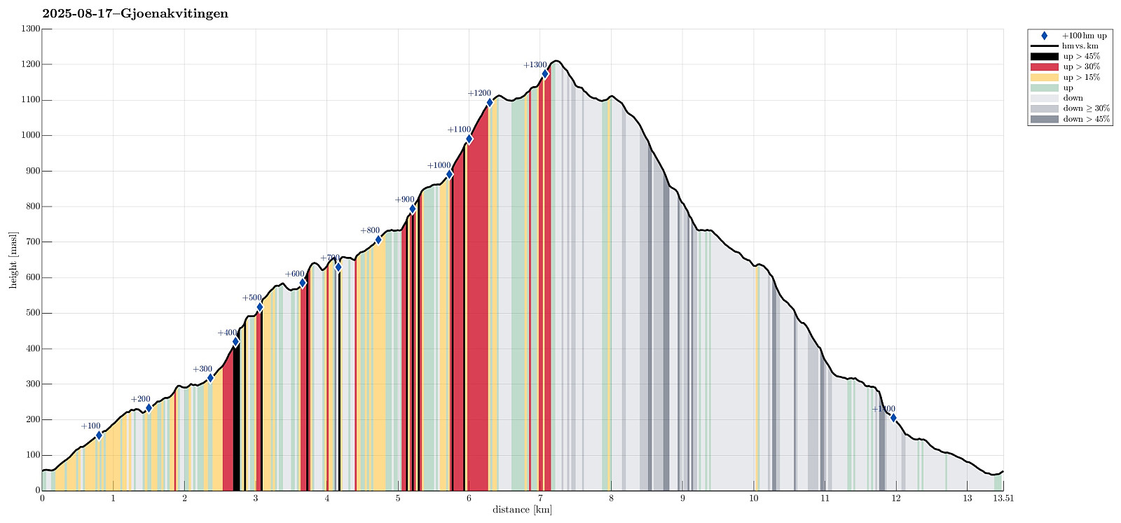
| Distance | 13.5km |
| Vertical meters | 1,416m |
| GPS |
|
| Ascents | Gjønakvitingen (1,213m) | 17.08.2025 |
|---|---|---|
| Selfjellet (591m) | 17.08.2025 | |
| Visits of other PBEs | Gjøn parkering nord (57m) | 17.08.2025 |
| Gjøn parkering sør (54m) | 17.08.2025 | |
| Gyttro (661m) | 17.08.2025 |
Trip Summary
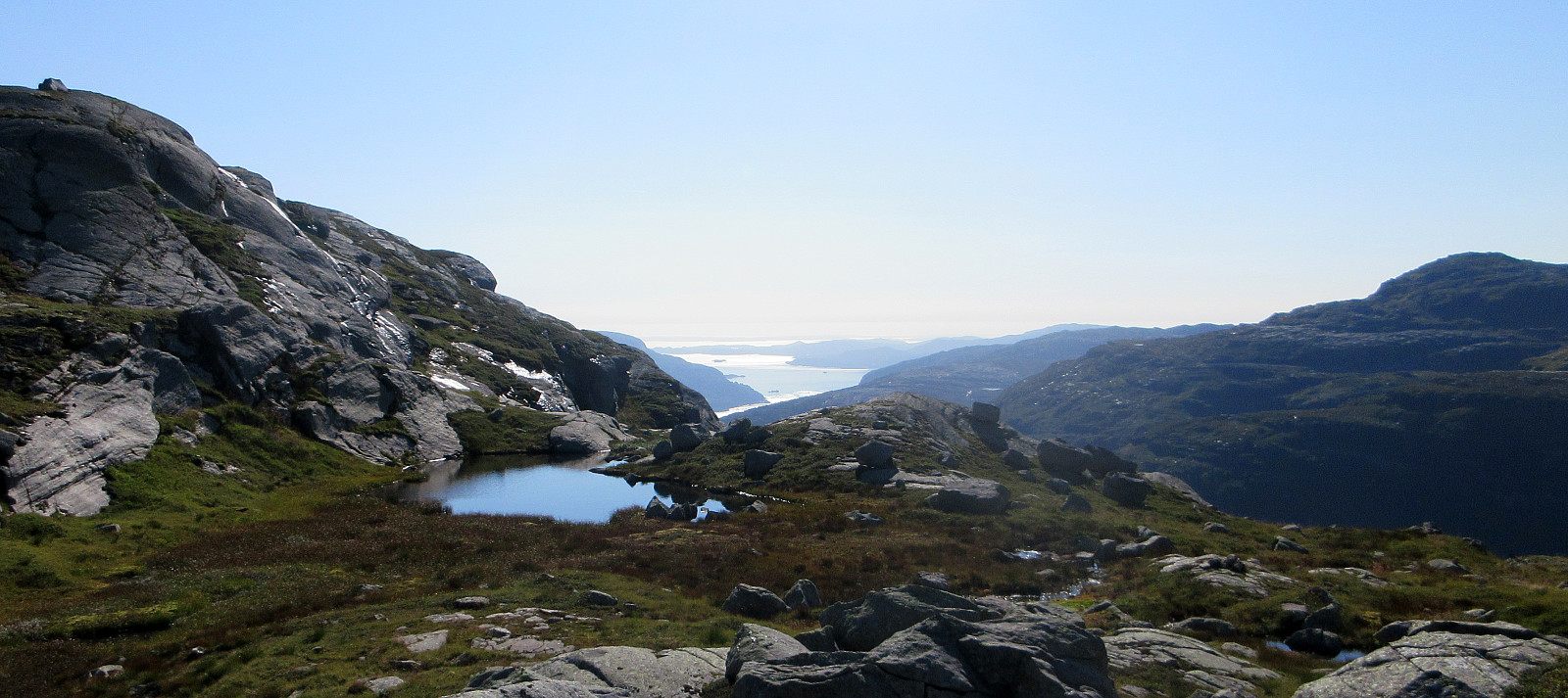
The weather was promising and so we thought this would be a good day to hike up to Gjønakvitingen from Gjøn. From Bergen, we drove towards the East, first along E16, then road #49, before taking road #48 to Eikelandsosen. From there, it was not too far, continuing into eastern direction, before we changed to a narrow road at Holdhus. This way, we drove around the south end of Gjønavatnet in order to get to Gjønavegen, which brought us to Gjøn. At about noon-time, we then started our hike (with enough time on such a nice, long summer Sunday). The one, small "twist", which we had cooked up, when studying the map at home, was to include Selfjellet (via an ascent on the western side of Skarvaelva), before eventually taking the "main trail" down (south of Sauaskorfjellet). We thus found our way to a nice gravel road, which conveniently lead us up to Kaldestegen, next to Stussekleiva. Where this tractor road then ended, we started to see remains of some trail markers (which clearly have been there for quite a while, already). Nonetheless, we still found something like a trail "all the way" up the lower end of Grønestølen (basically northwards in parallel to Russagjelet of Skarvaelva on the western side of the stream). North of Småholena, the terrain gets quite a bit steeper, then, but still every now and then a (former) trail marker can be found. Especially when getting close to the southeastern cliffs of Selfjellet, one needs to scramble a bit to get over (and up!) some big rocks that have come down from the cliff above. Once a few meters higher, however, it's continuing more straight-forward again and it did not take us long, before we entered the rather idyllic (and also quite flat) spot in the east of Selfjellet -- indeed a very nice place with a special athmosphere! The rest of the ascent to Selfjellet was then without any difficulties (a bit steep in a section, but all good). From Selfjellet, however, one then can enjoy best-possible views (mostly towards the south) -- really, really nice! :-) To continue our hike, we then crossed over to Nutane via the saddle between Selfjellet and Nutane. The southern flank of Nutane comes also with some minor cliffs. Therefore, we decided to cross diagonally towards the southeastern ridge of Nutane before doing the actual ascent of this hill. Yes, this resulted in a minor "bush war", but after a few minutes, we still made it up to Nutane without troubles. Next was a simple traverse to Gyttro and from there, one gets again quite amazing views (also down to Gjønavatnet and Kikidalen at its northern end). From Gyttro it was then mostly following the "main trail", which first leads up to Vardaheia, before entering Norddalen. The trail then leads up (and towards the east) through Norddalen. Basically right at the saddle (between Midthorga in the south and Kvitingsnibba in the north), the trail then leads sharply northwards (and the southern flank of Kvitingsnibba). We did however manage to miss that "corner" and walked further towards the east and over the saddle. Relatively quickly we then understood that our goal was "up the hill" and thus we left the valley, which continues further towards Kvitingsvatnet, and found our own route up Kvitingsskorane. This ascent variant worked out well (yes, it's steep there, but making progress off-trail was still without difficulties). Quite a bit up this mountain-side, we then rejoined the trail and followed it towards the top of Gjønakvitingen. The trail markers are not always immediately visible, but at large it is still rather straight-forward to follow them. Given the "all rocks" terrain up there, one anyway can choose rather freely where to go. After a nice short rest on Gjønakvitingen, we then started our hike back (instead of also including Loftet), considering that we did not wish to end up in the later evening, after all. To get back down, we basically followed the main trail. From Gyttro, where we had joined this trail on our way up, we then continued along the "main trail", which extends diagonally down underneath some quite impressive cliffs in the south of Sauaskorfjellet. In the northeast of Skjenstøhaugane, one then crosses a rather wet and flat meadow (and one needs to look out a little to find the continuation of the trail on the other side). This brings on towards a part of the trail, which is close to (while still high above) Gjønaelva (on its western side). Since one still needs to make quite a few height meters further down (basically down Uglefluga on its southeastern end), it's important to actually follow the trail there in order to avoid ending up in a suddenly too steep section. Southeast of Uglefluga, once rather close to Brakhaugen, already, the trail situation becomes unclear, again. Instead of further following the trail from there, we instead stepped out and onto a gravel road that lead us to a convenient crossing of Gjønaelva just a short stretch further down. From there, it was then just to walk down some forest road (via Fosshaugen) to get back down to Gjøna. Altogether, this clearly was a somewhat longer hike and taking enough time for it was smart (and necessary). :-)
Photos
Selected photos are available as Google photo album.
Useful Resources
See also the related FB-page Hiking around Bergen, Norway.
Web page WestCoastPeaks.com provides useful information about Loftet, Gjønakvitingen, Kvitingsnibba, and Selfjellet.
Web page UT.no from the Norwegian Trekking Association recommends a similar hike.


User comments