
Bike-hiking hills near Drotningsvik (06.10.2024)

Written by HHauser (Helwig Hauser)

| Start point | Varden (45m) |
|---|---|
| Endpoint | Varden (45m) |
| Characteristic | Bike trip - mixed |
| Duration | 4h 00min |
| Distance | 32.9km |
| Vertical meters | 1,201m |
| GPS |
|
| Ascents | Alvehaugen (89m) | 06.10.2024 |
|---|---|---|
| Godvikaskjenet (60m) | 06.10.2024 | |
| Høyde ved Janaflaten (89m) | 06.10.2024 | |
| Ramsvikhaugen (69m) | 06.10.2024 | |
| Skipparhaugen (64m) | 06.10.2024 | |
| Storhaugen i Godvik (70m) | 06.10.2024 | |
| Storhaugen (36m) | 06.10.2024 | |
| Storhaugen i Alvøen (75m) | 06.10.2024 | |
| Visits of other PBEs | Hellersfjellet (65m) | 06.10.2024 |
| Hellersfjellet gapahuk (59m) | 06.10.2024 | |
| Hetlevikstraumen bro (3m) | 06.10.2024 | |
| Ramsvikhaugen utsiktspunkt (53m) | 06.10.2024 |

Trip Summary
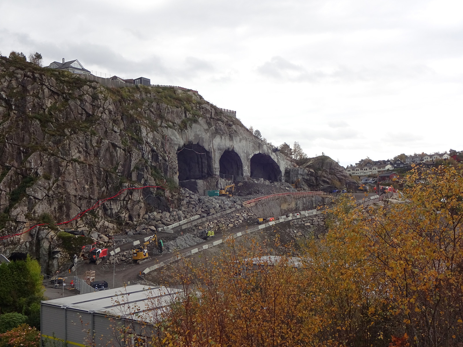
Given the medium-nice weather -- certainly good enough, though! -- I decided to make another bike-hiking trip: this time into the direction of Drotningsvik, where I knew of a couple of hills that I had not visited so far. I started by cycling into the direction of Olsvik, passing by Loddefjord on my way. In the northwest of Harafjellet, I then left my bike behind for the first time, making my way up to Storhaugen. Given the houses that have been built right up to the "top" of Storhaugen, one does not really get any nature feeling up there. The views, however, are quite fine. Next, I aimed at Godvikaskjenet, approaching it from the northeast. Godvikveien leads up there quite steeply and I left my bike behind "half way up" that road. Once closer to the "top", I walked around the house that is placed highest up there to get "around" and to the "top" of Godvikaskjenet. To get back to my bike, I finished a short and elongaged round. Back on my bike, I then headed southwards (into the direction of Alvøen), passing by Stølavatnet on its western side. Coming close to Alvehaugen, I then decided to quickly check whether I would find any reasonable way to get up there, too. After biking half way around this hill and a bit back, again, I then saw that ascending to Alvehaugen is possible from its northern side (NNW). Clearly, others have used this route before. Once on the heights of Alvehaugen, getting to the highest point was easy. After making one round around the big circular structure on Alvehaugen, I basically descended from Alvehaugen along the same route that I had taken up, first. My next goal was then Skipparhaugen, but while biking into the direction of Skipparhaugen, I noticed another hill further north: Varden. After quickly exploring this hill, also, I then made it down to Nordre Drotningsvik from where I hoped to step up to Skipparhaugen. Below the bridge, I looked for a good spot for making the first step up. Eventually, I decided to not search too much, but simply use my hands and help myself up the rocks right next to the road. Once up there, continuing further upwards to Skipparhaugen was then easy. From Skipparhaugen, I may say, one really has some nice views, including views to the near Sotrabroen, the not so near Askøybroen, Byfjorden, etc. Instead of stepping right back to my bike, I instead found a way to get down from Skipparhaugen on its southwestern side. Walking then southwards along Vestre Drotningsvikveien brought me to a good point, where I could make a short detour up to Storhaugen. Given the large bridge construction, there, these days, one gets some nice close-up views on the ongoing bridge construction. Due to the construction site, it was not possible to connect to Janaveien right there, instead I had to bike around Janahaugen in its east. South of Janahaugen, I then left my bike behind, again, to include a short excursion to Ramsvikhaugen (and the viewpoint a bit further south). Indeed, one gets some very nice views across the strait that separates "main land" Bergen from Sotra (Litlesotra). Since I was so close, already, I then decided that I could check out the viewpoint at Hellersfjellet, also. Indeed, I could look down to Ramsvik from there. :-) Roughly speaking, it was time to get back home and I had thought that I could cycle around Små- and Storavatnet in their southwest. To get there, I first connected to Alvøen. Before cycling down to Alvøveien, though, I still had one more excursion to include: up to the little hill in the southeast of Janaflaten. I found a nice route over the entire ridge and made it to Janaflaten quite quickly. I then thought that I could walk back along the road, just to find that Janaflaten and Alvøens skolevei are not connected right west of the ridge. That meant that I had to get back up onto the ridge to get back to my bike. On my bike, again, I then connected to Alvøveien, which I then followed southwards. Biking along Håkonshellaveien, I then thought that I also could include a short ascent to Storhaugen i Alvøen. This hill is very easy to ascend, but getting there is a bit of a challenge (the whole area is fenced in). After leaving my bike behind, I first walked along the fence to find a good spot for getting over to the other side. Eventually, I used the gate in the southeast of the hill. From there, it was then quick and easy to get to the "top" of this hill. Back, I then took a more direct route, also finding a good spot for getting over the fence without doing any damage. After all, this was the last "leave my bike behind" break. Biking along Håkonsvernveien, I then used the small bridge over Hetlevikstraumen to get over to Bjørndalsbrotet. From there, it was then just back to Varden, following Bjørgeveien.
Photos
Selected photos are available as Google photo album.
Useful Resources
See also the related FB-page Hiking around Bergen, Norway.


User comments