
Pollatinden from Råkeneset (14.07.2021)

Written by HHauser (Helwig Hauser)

| Start point | Råkeneset (5m) |
|---|---|
| Endpoint | Råkeneset (5m) |
| Characteristic | Hike |
| Duration | 8h 30min |
| Distance | 15.0km |
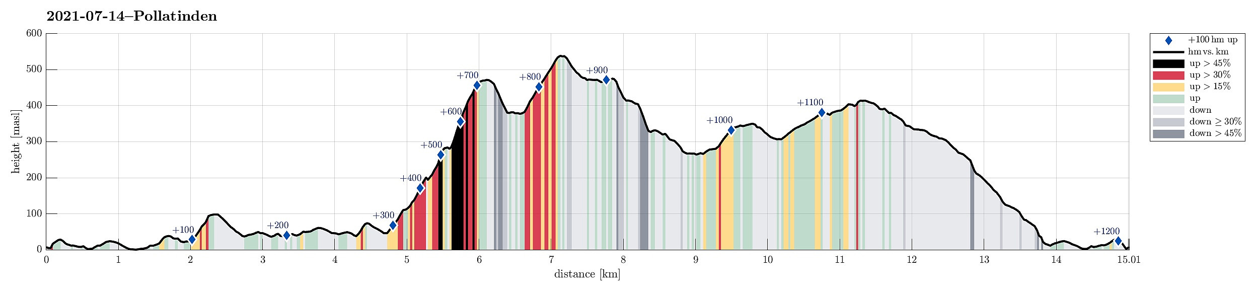
| Vertical meters | 1,210m |
| GPS |
|
| Ascents | Fonnaheia (415m) | 14.07.2021 |
|---|---|---|
| Pollatinden (542m) | 14.07.2021 | |
| Visits of other PBEs | Råkeneset (4m) | 14.07.2021 |
| Råkeneset p-lomme (10m) | 14.07.2021 |
Trip Summary
The "big" hiking plan of these few days in Solund was to hike Pollatinden -- but to do this from Råkeneset, where we stayed overnight before and after. The matter of fact that Pollatinden, as well as quite a few of the other landmarks around it, exposes significant cliffs towards the west/northwest (and Råkeneset is exactly in the northwest of Pollatinden), turned this hiking plan into a non-neglegible challenge. When studying the map, it appeared that we could follow one of two routes of "attack": either from the north (via Råkefjellet and then up between Sandvikfjellet and Pollatinden) or from the south (via Storefjellet), while the "standard" approach to Pollatinden (as marked trail) is from the southeast, i.e., exactly from the other side of the mountain, when compared with our starting point at Råkeneset. Since we were not sure about how difficult the ascent to Storefjellet would be (from its south), we decided to rather take this part uphills and thus approach Pollatinden from the south (via Storefjellet).
Prelude
To actually get to the point, from where we could start our ascent to Storefjellet/Pollatinden, we first needed to hike from Råkeneset in the northwest of Pollatinden to Medbotnen in the south of Storefjellet. After first walking out to the road from Råkeneset, we then followed the road southwards, crossing over between Råkevågen and Råkepøyla, to get to the point, where a (sparsely) marked trail leaves from the road "into the wild". Following this trail, we surrounded the house at Bakkane (in the north of Ramnefjellet) before "sneaking" into a little valley (in the east of Ramnefjellet) that leads up and over a little saddle in the north of Råkevatnet. Back down on the southern side of this saddle one comes close to Råkevatnet (in its north), before the trail turns westwards for short stretch. This way, we could start to hike past Råkevatnet on its western side, especially after crossing over the little stream to runs out of Råkevatnet and down to the sea in its northwest (that's also the place, where another trail comes up from the road in the west of Råkevatnet). Following the marked trail, we continued further southwards (between Liafjellet in the west and Råkevatnet in the east), until we came close to Storemyra in the northwest of Medbotnen. There, very close the southernmost point of Råkevatnet, we decided to leave the trail and head towards the actual starting point of our ascent to Storefjellet and Pollatinden without any trail.
Storefjellet and Pollatinden
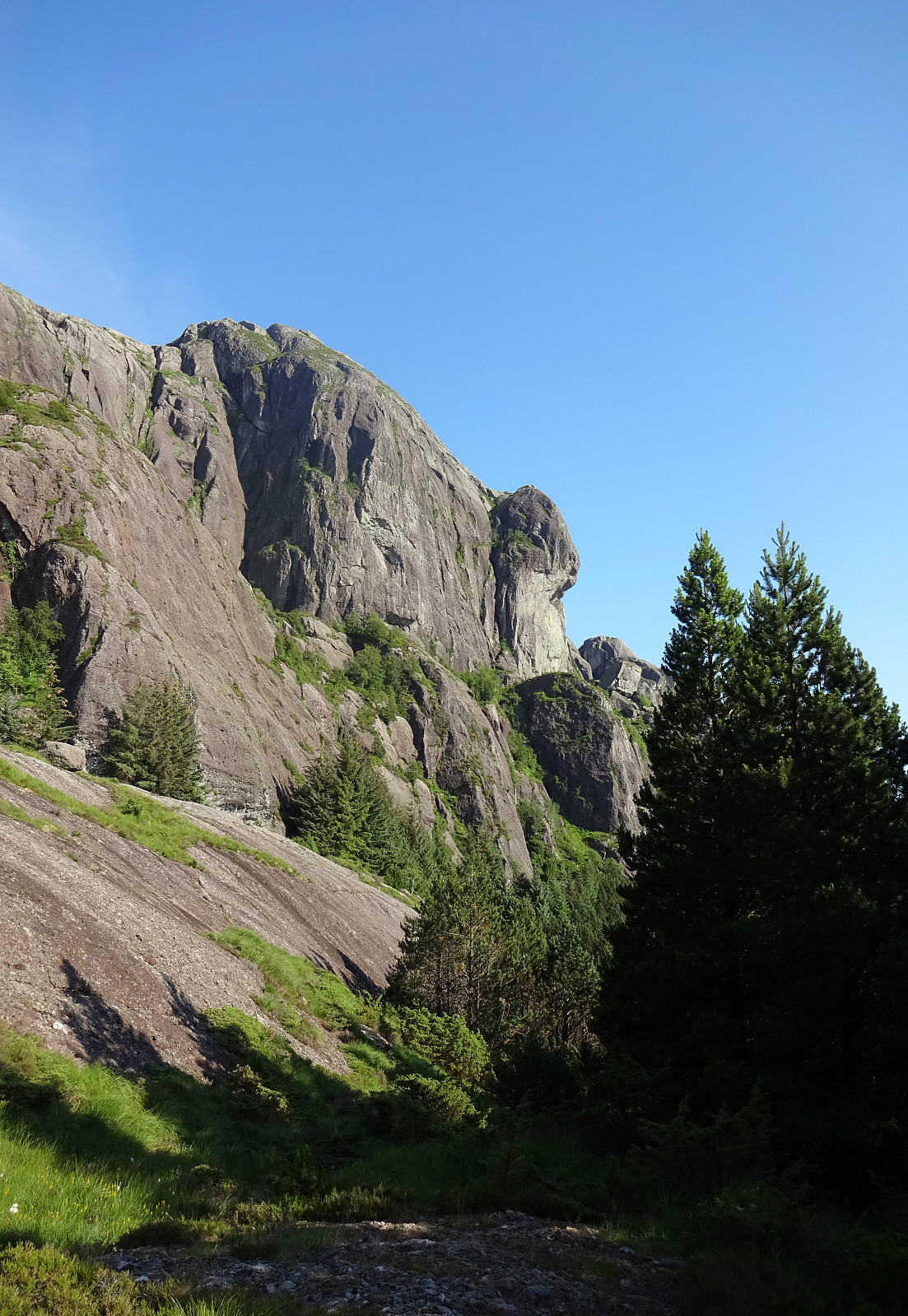
After crossing over the wet area in the south of Råkevatnet, we aimed at a little saddle that appeared to be suitable for bringing us further to the southeast (and towards the actual south of Storefjellet). And it indeed was well doable to cross this saddle, continuing as planned into the next valley that is connected with Medbotnen a little further down towards Storevatnet (this valley apparently also serves as shooting range -- so some care is probably advised when crossing it while hiking off-trail). After crossing the valley (at about 45mosl and underneath the impressive western cliffs of Storefjellet), the ascent to Storefjellet starts with relatively easy connection (first in southeastern direction, then turning more northeastwards) that is useful to get around the western cliffs of Storefjellet and to enter its southern slope (Veddalsbrekka). This connection brings one to a small, kind of flat spot at about 110mosl, from where the main part of the ascent to Storefjellet starts. At large, one can subdivide this ascent into three sections: First, we headed up in northwestern direction, passing over gress and rock amounting to a steep but well doable ascent and ending up at a little outpost (at about 200mosl) from where we enjoyed some very nice first views already! Next, we had to cross a slightly more challenging secion (now in northeastern direction) that required a little bit of extra concrentration (and the occasional use of both hands in addition to our feet). This stretch, leading up to about 300mosl, appeared to be the most challenging part of getting up to Storefjellet. Last, from about 300mosl to the top of Storefjellet at about 475mosl, was again steep but well doable. Recognizing that we actually would manage this ascent, we enjoyed some relief, paired with a lot of joy due to the wild and impressive nature around us (and no other soul, of course). At Storefjellet, we then enjoyed a first proper break, as well as many nice views in all directions. Thereafter, we were ready to refocus our attention at the next goal, Pollatinden. To get there, we had to cross Tjørndalen (in the northeast of Storefjellet) to get up onto another "ramp" that would lead us up to Pollatinden (from its south). Both the descent from Storefjellet and the connection to the targeted "ramp" via Tjørndalen worked out nicely and without any problems. Equally, the "final" ascent to Pollatinden was straight-forward and without any mentionable difficulties. Obviously, we were very satisfied after reaching the top cairn of Pollatinden via this off-trail ascent!
Råkefjellet and Fonnaheia
While glad about getting up to Pollatinden "as planned", we clearly knew that quite a bit of challenge was still ahead of us! Getting down from Pollatinden in northwards direction would not be easy for sure, maybe impossible. Our plan was to first aim at a little valley in the northeast of Pollatinden (between Sandvikfjellet and Pollatinden) and to (hopefully!) find a way to descend further down from there then in northwestern direction. In the beginning, all this started well and the descent into this valley was pleasant and nice (and gentle!). But once we came close to the little water at about 465mosl, we found out that continuing further down was clearly non-trivial. Our first attempt to get down (in the north of the little stream that runs off this little water) ended up at the top of some cliffs that were clearly to high to scale down. Luckily, we got a better view to the other, southwestern side from there, suggesting that a descent could possibly work out there (after first starting a little higher up). Reteating a little stretch then (and surrounding this little water at 465mosl in its east to get to the other side) brought us over (and up to 475mosl), so that we could give this descent a second attempt. Fortunately, it turned out to be possible on this side (quite steep, yes, but nicely doable, especially with a bit of extra help of our hands). Once down below 450mosl, we had left the steepest cliffs behind us and progress was a bit more straight-forward. Still a lot of care was needed, especially due to a bit of vegetation that has overgrown the still steep field of rocks there, making it difficult to see what's underneath. Another 25 height meters further down, the situation improved further and progress became faster, again. Instead of heading further in northwestern direction (most likely too steep!), we instead hiked northwards and over a small saddle to bring us onto another slope that would bring us down from about 400mosl to a lake at about 325mosl (in northern direction). While steep, this slope was clearly well doable (with some care) and it did not take us long before we arrived very close to the lake. From there, the plan was to get down to Søre Kvernhusvatnet (now in western direction, all in all). Getting over from the one lake to the other was then nice and easy -- just right at Søre Kvernhusvatnet we had to somehow pass by a rather steep, west-facing cliff. After also managing this traverse, we eventually ended up at the eastern side of Søre Kvernhusvatnet, right underneath some impressive cliffs, where we enjoyed another nice break. With new energies, we then continued our hike that would first bring us further north (and up to Fonnaheia, before we imagined to find an opportunity to get back down to Råkeneset using the "diagonal ramps" in the west of Råkefjellet. But first we had to get to Fonnaheia! :-) Even though this meant to cover some additional distance, progress was easy over the gentle heights of first Råkeneset and then up to Fonnaheia. Several times, while appraoching Fonnaheia and finally up there, of course, we turned around and enjoyed some nice views towards Pollatinden -- indeed an impressive mountain (not only from this perspective)! :-)
Conclusion
When studying the map ahead of time, it became clear that making some proper decisions would be crucial to actually make it back down to Råkeneset on this side of the mountain(s). It's just so that several tall and long cliffs (towards the west) must be respected as obstacles that are impossible to get over along most of their extent. The upper-most of these cliffs (in the west of Råkefjellet) is such an obstacle from very close to Fonnaheia in the north (and all the way to south of Råke in the south). To circumvent this obstacle, our plan was to get down to its western side (underneath the cliff) right at Fonnaheia and to follow this "ramp" down then in southwestern direction, passing over a slope that is also called Mjølkestigen on the map. Once down to about 250mosl, it would become important, again, to find the right continuation as about there another west-facing cliff starts to separate this "ramp" into an upper, eastern part (that probably amounts to a dead-end route for those, who'd wish to descend all the way), and a lower, western part (also called Slettebakkane on the map). Once there, we assumed that getting all the way down to Råke would be OK. Fortunately, when getting into the west of Fonnaheia, we got to see some trail marks, leading down into the right direction! :-) And indeed, we could then follow this marked trail down exactly along the planned route (on no map, that we had studied in advance, this trail was shown, though). This way, all this descent, which we had approached with quite some respect, turned out to be nicely doable, providing us with a pleasant and enjoyable way to round off this nice hike! :-)
Photos
Selected photos are available as Google photo album.
Useful Resources
See also the related FB-page Hiking around Bergen, Norway.
Web page WestCoastPeaks.com provides useful information about hiking opportunities on Solund.
Web page UT.no from the Norwegian Trekking Association recommends the "standard" hike up to Pollatinden.


User comments