
Visiting Myrdal Våpenlager and Skavdalsfjellet (15.05.2021)

Geschrieben von HHauser (Helwig Hauser)

| Startpunkt | Øvre Dyngeland (75m) |
|---|---|
| Endpunkt | Øvre Dyngeland (75m) |
| Tourcharakter | Wanderung |
| Tourlänge | 4h 00min |
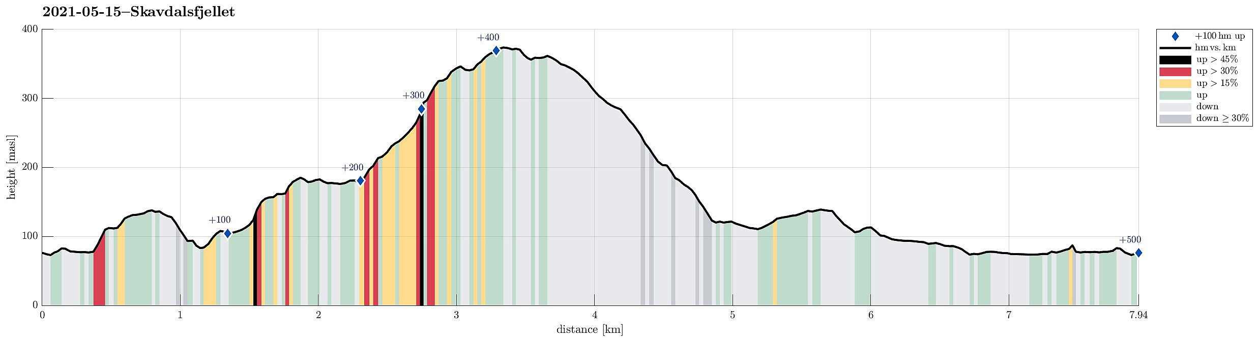
| Entfernung | 7,9km |
| Höhenmeter | 498m |
| GPS |
|
| Besteigungen | Barkahaugane (159m) | 15.05.2021 |
|---|---|---|
| Fjellet (142m) | 15.05.2021 | |
| Kattuglehaugane (188m) | 15.05.2021 | |
| Stordalsfjellet (376m) | 15.05.2021 | |
| Besuche anderer PBE | Johnsahytta (ruin) (138m) | 15.05.2021 |
| Myrdal Våpenlager (115m) | 15.05.2021 |
Trip Summary
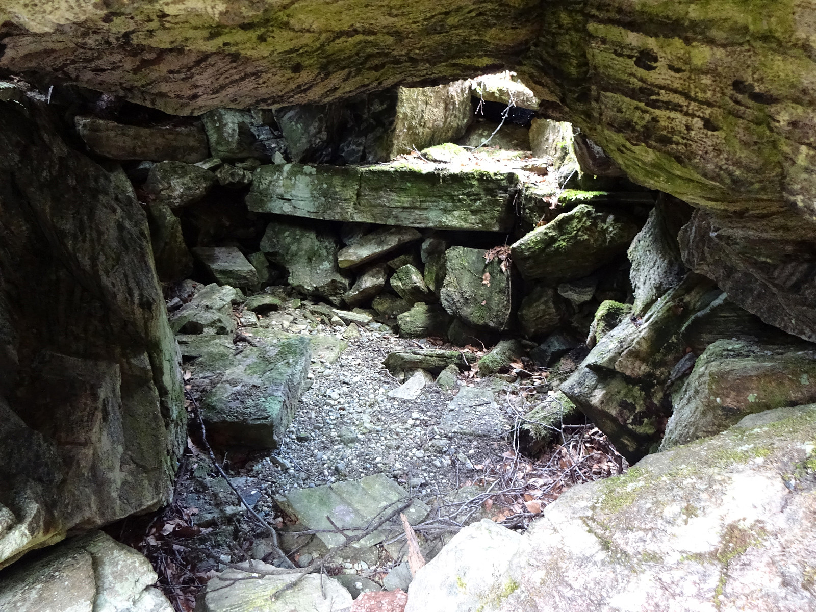
With the weather being forecasted as "grayish", the plan was to do something below the higher tops. Ever since we had visited Bautasteinen in the north of Krokvatnet near the top of Livarden, which made us read up on Johannes Dyngeland and related history, we had a little plan "on the shelf" to "one day" go and search for this place in Langedalen, where they apparently had hidden weapons while resisting the NS-occupation of Norway. We started in Nedre Dyngeland, where it is not really easy to find an appropriate parking spot. After passing by Grøvlet in the north of Dyngelandsvatnet, we approached the saddle in the north of Fjellet (marked with Fjellsenden on the map) on something that could be called a minor trail. Once on the saddle, we decided to also include a short detour via Fjellet, stepping up to its "top" within a few minutes thereafter. After crossing over the "top" of Fjellet (moderately exciting), we descended (basically without a trail) towards the gravel road (Dyngelandseidet) that comes up from Myrdalsvatnet further south. Without really walking along this road, we continued further (downwards) in eastern direction (into the direction of Kattuglefjellet). From there, we then followed the little stream that comes down from Langedalen in northeastern direction. In the west of Barkahaugane, we crossed the trail that connects Stordalen and Dyngelandseidet. Only about 150m further along the stream, on its eastern side, we then located the place. It's basically a big rock with a little and low "room" underneath. Furthermore, one can still see the remains of some wooden cover over a little area in the south of the rock. No sign or info-plate whatsoever is found at this place, which is kind of sad given the historic significance of that place. After inspecting the place a little, we then decided to continue. After looking up the very steep hillside in the east of this rock, we still got the impression that ascending it in order to get up to Barkahaugane should be possible (and it is, in fact, even though using our hands was natural every now and then). Within short, however, we had stepped up and resumed "normal hiking mode" (without trail, though) from there. From Barkahaugane, one de facto can enjoy some quite nice views, mostly in southern direction. The matter of fact that this area apparently had burnt quite severly some years ago contributes that the hill tops around there are mostly free from dense forest vegetation. Thereby, both proceeding (even though there aren't any trails) and also watching works quite well! :-) From Barkahaugane, we then continued northwards, arriving at Kattuglehaugane only a few minutes later. From there, the view towards Stordalsfjellet is really nice! After briefly discussing the continuation, we decided to give Skavdalen and Stordalsfjellet a chance. Walking over the hilltops in the northeast of Kattuglehaugane was then easy and nice, we even got the impression of occasionally following something that may be taken as a trail! :-) At about 175mosl, we then entered Skavdalen and started to step up through it into the direction of Fjellklova. Also in Skavdalen, we followed something that either is an old trail or a well-used deer track. This way, it was easier than expected to actually proceed upwards. Within short, we arrived at the lower, southwestern end of Fjellklova. Also there, we had the impression to actually continue on a (just so visible) trail. While we had been prepared for some challenge (up through Fjellklova), also this stretch turned out to be easy and straight-forward. All in all, hiking Skavdalsfjellet via Skavdalen is clearly a very reasonable opportunity! :-) After refreshing ourselves nicely at Fjellklovevatnet, we then started our way back, crossing over Stordalsfjellet along the way. Due to its fairly steep western flank, this little mountain really offers some very nice views! Following the trail down along the southern ridge of Stordalsfjellet (avoiding the very steep Stordalsliane on its western side), we made it down to Stordalen and from there, also following a nice trail, back to Dyngelandseidet. Where the gravel road "turns around" (and towards Dyngeland), we visited a nice bench, directly at Myrdalsvatnet. To get back, we then rounded Fjellet, passing by Dyngelandsvatnet on its eastern side. This way, we connectd to where we had started rather quickly. All in all, it's interesting to visit historic places "in the middle of the forest" and it's a little sad that there is nothing that would help visitors to either find this place and neither any information at the place. A tiny little plate with a least a few lines of information would definitely be nice.
Photos
Selected photos are available as Google photo album.
Useful Resources
See also the related FB-page Hiking around Bergen, Norway.
The web pages of Fana Turorientering provide a bit of information about Myrdal Våpenlager.
Petter Bjørstad has a useful page about Skardalsfjellet and also web page WestCoastPeaks.com provides useful information about Skardalsfjellet.
Web page UT.no from the Norwegian Trekking Association recommends another hike via the south ridge of Stordalsfjellet.


Benutzerkommentare