
Skarsnosi from Jordalen (07.08.2020)

Geschrieben von HHauser (Helwig Hauser)

| Startpunkt | Jordalen (655m) |
|---|---|
| Endpunkt | Jordalen (655m) |
| Tourcharakter | Wanderung |
| Tourlänge | 5h 00min |
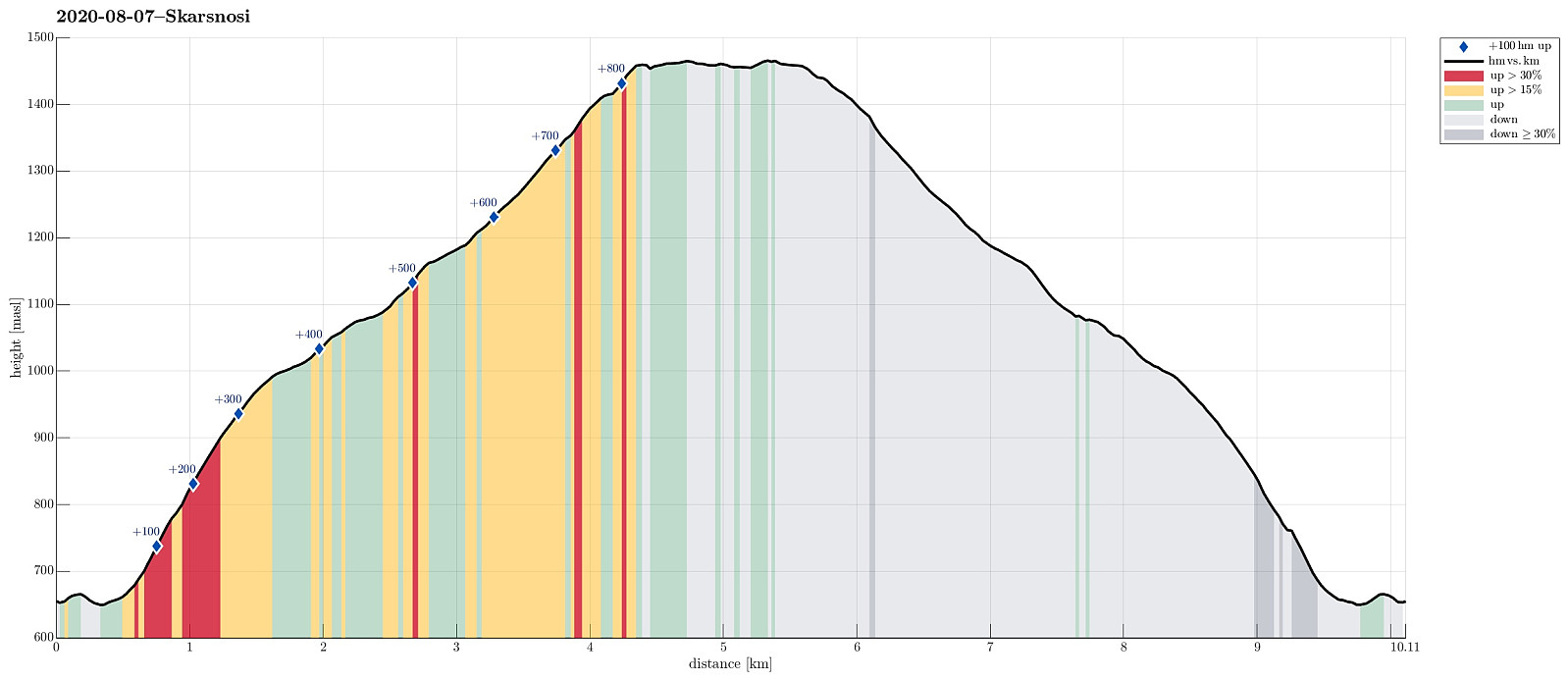
| Entfernung | 10,1km |
| Höhenmeter | 883m |
| GPS |
|
| Besteigungen | Skarsnosi (1.470m) | 07.08.2020 |
|---|
Trip Summary
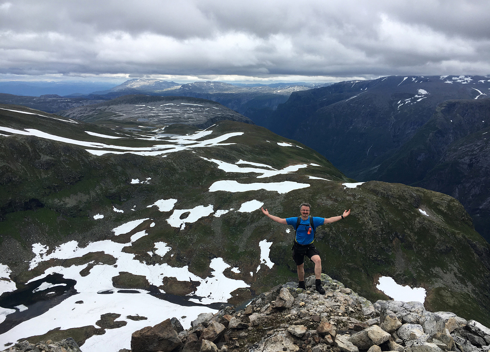
We expected a nice day and thought about Bakkanosi, since we had not been there before. Looking down onto Nærøyfjorden from this place sounds like a worthwhile experience! We thus drove along E16 into the direction of Gudvangen, passing by Stalheim. Quite a bit down in Nærøydalen, we then turned left and used the new tunnel up to Jordalen. Not far up in Jordalen, where Slettedalen comes down from the East, one would park to start the "standard hike" to Bakkanosi (through Slettedalen). Coming there, we were shocked about the relatively large number of parked cars and immediately changed our plan. Instead of Bakkanosi, we now planned for Skarsnosi, not far from Bakkanosi. To get up there, we had thought to hike up the next valley (north of Slettedalen). To do so, we drove further up through Jordalen, passing by Nosi, and stopping a short bit before the road crosses Kåsteinselvi, becoming a toll road from there. Starting our hike there, we crossed the same bridge to the eastern side of the valley, but turned right (southwards, into the direction of Sendo) right after the bridge. A few meters further south, we came to a small buildling complex down in the valley. From there, we had intended to look out for an opportunity to ascend towards Skarsnosi, stepping up through the valley between Vardafjellet in the north and Kråkenosi in the south). Near the buildings (still down in Jordalen) we had to first cross a still fresh looking, big stone slide, which recently came down from Vardafjellet. Once across this big scar in the landscape, we started our ascent. According to our plan, we sticked to the northern side of the valley, which is more smooth and easier to traverse. A bit up into our ascent, we even used a trail for a few height meters (close to the stream that comes down the valley). Soon after, when getting over the first edge, which separates "our valley" from Jordalen, we continued over some very pleasant grass fields (wet, yes, but very smooth to walk over!). Continuing steadily upwards, we headed towards Skarsnosi without any difficulties; in fact, this valley between Vardafjellet and Kråkenosi is very, very nice! Once above (approximately) 1200mosl, the valley turns a bit (from northeastern direction to eastern direction). There, the terrain changes into stones (and snow). Still, it's straight-forward to continue further towards Skarsnosi. On Skarsnosi, there are several sub-tops to visit. The northern-most sub-top provides stunning views over Rimstigen, just breath-taking! From the highest point on Skarsnosi (further south), one can see down to Nærøyfjorden, also. Once satisfied with the views (and a short break with some bread), we turned back, returning first down again into the valley that we had come up first (and then down the same valley). All in all, this hike was really excellent (and not a single other person to see).
Photos
Selected photos are available as Google photo album.
Useful Resources
See also the related FB-page Hiking around Bergen, Norway.


Benutzerkommentare