
Brakstadfjellet, Tveitanipa, and Røysetfjellet (10.04.2020)

Geschrieben von HHauser (Helwig Hauser)

| Startpunkt | Vollo (35m) |
|---|---|
| Endpunkt | Vollo (35m) |
| Tourcharakter | Wanderung |
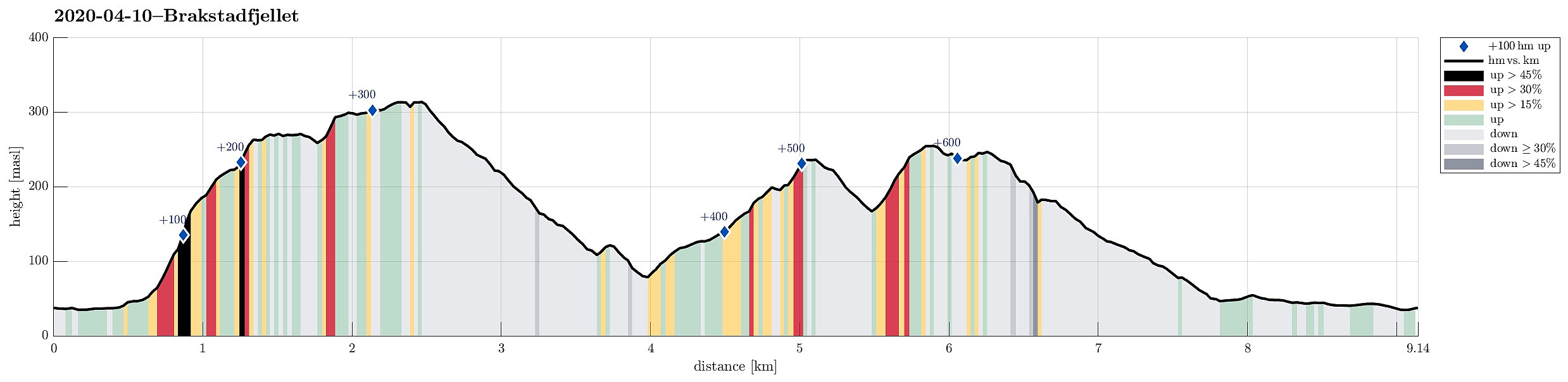
| Tourlänge | 3h 30min |
| Entfernung | 9,2km |
| Höhenmeter | 641m |
| GPS |
|
| Besteigungen | Brakstadfjellet (317m) | 10.04.2020 |
|---|---|---|
| Røysetfjellet (257m) | 10.04.2020 | |
| Tveitanipa (243m) | 10.04.2020 | |
| Besuche anderer PBE | Vestbygdvegen P-lomme (35m) | 10.04.2020 |
Note that the ascent to Brakstadfjellet (as well as the descent from Røysetfjellet) were at large without any trail (and very steep).
Trip Summary
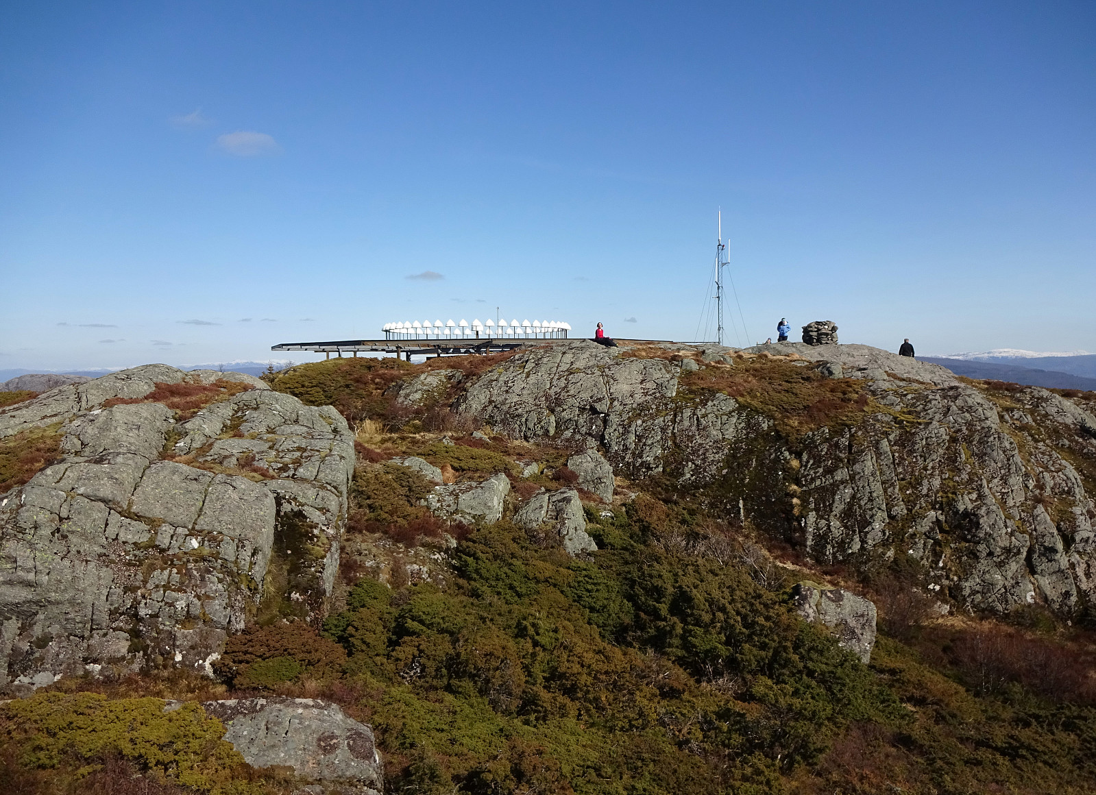
The weather report suggested the further north one may have better chances for some sunshine. So, a top, which had been waiting on our wish-list for a long time already, got picked as trip goal: Brakstadfjellet. The car brought us north from Bergen and over Nordhordlandsbrua. Turning left at Flatøy brings one over the bridge over Krossnessundet onto Holsnøy. Following road 564, we passed Frekhaug into the direction of Fløksand. Near Holme, we turned right (onto road 5314), driving further to Tveit. Eventually using road 5308, we ended up near Brakstadvatnet at Vollo. There, a somewhat extended bus stop offers good opportunities for parking. Before starting from Bergen, we had checked the map in order to understand, which alternatives there are for ascending to Brakstadfjellet. This did not lead to any other finding than the main route, which starts right at this parking in northern direction from the road, following a gravel road first (before later turning left and westwards to the actual ascent to Brakstadfjellet). Right at the beginning of this gravel road, however, we saw a little map, mounted there alongside the road, which indicated that also another (more direct) route should exist from Indre Brakstad. The map suggested that one just follows the road a few meters further, half way around Brakstadvatnet, before there following a short road northwards into Indre Brakstad. There, one should turn left and follow a gravel road upwards (into the direction of Kjeken, ascending parallel to Langaberget). Very interested in making our hike a nice little round, we decided to give this alternative a try and walked towards Indre Brakstad first. At the end of the short road, which extends northwards from Brakstadvatnet, we apparently missed the right moment to turn left in order to continue to the gravel road. Instead, we came close to the house at the end of the road. There, we met the owner, who clearly did not like the idea of others nearby. Kindly asking of how to best continue to the gravel road did not help. Eventually, we left the place by directly stepping into the forest in the north of the house. We first thought that we would connect diagonally to the gravel road (in western direction). After a couple of meters, however, we "hit" a fence. Deciding not to cross it (and possibly do damage to it), we instead followed the fence in northern direction -- VERY steeply upwards Langaberget. Some 50 or 60 height meters further up, we crossed a little stone wall and turned left there. After first stepping a little further (diagonally along Langaberget) in western direction, we turned further northwards, again, stepping up the VERY steep mountain side of Langaberget (clearly possible, but at the limit of what one can step up without getting down on all fours). In the southwest of Nipa, south of Brakstadfjellet, the terrain gets more level (at about 220mosl). Heading slightly in western direction, we there met the trail that we originally had wished to find (much further down, of course). Once on this trail, it was straight-forward (while still very steep) to continue further upwards and soon after, we found ourselves on a major saddle between Brakstadfjellet (in the east) and its western shoulder. In order to first enjoy some nice views from there, we continued first further towards the west, ascending the little height west of the saddle. Indeed, this place offers very nice views to the west and over everything that's between the viewer and the North Atlantic far out. From there, we then returned first to the saddle and from there up to the main height of Brakstadfjellet. Before, however, going to the actual top, we explored another "nose" of Brakstadfjellet -- now in its north/northwest. From there, one can see nicely over to Eldsfjellet in the north of Brakstadfjellet. Then, "finally", it was time to actually get over to the top of Brakstadfjellet with its enormous construction on top! Looking like a landed UFO, it more likely is a large radar, or something alike. At its actual top, one can enjoy great views in southern direction, seeing all the way to Bergen and its "city mountains". We then followed the main trail down (on the eastern side of Brakstadfjellet). Clearly, this is much more a beaten track than our ascending route -- very muddy indeed! At about 155mosl, near Sjurdalsleitet, we turned left (a little too early!) and started to descend towards Sjurdalen. A few meters into this descent, we realized that we had turned left too early. Discussing briefly of whether to go back, or not, we decided that we could simply make another little loop out of this excursion. Accordingly, we continued downwards for a little longer, before leaving the trail, crossing a little stream, and ascending on the other, northeastern side towards a little saddle, which looked like offering a connection to the next valley (coming up from Myrtveit). On the other side, we quickly understood that descending would be rather steep. Anyway, our progress was swift and easy (first), before we had to take a little extra care, before eventually stepping down to the bottom of the valley. Once on the forest road, we easily walked back up (now in southern direction), before we easily found the trail head to Tveitanipa (nicely marked anyway!). The trail up to Tveitanipa winds back and forth, crossing some quite varied terrain. We enjoyed some nice views from the top, but continued rather quickly further into the direction of Røysetfjellet. This brings one first down into another saddle at about 165mosl, before one finds the trail head for Røysetfjellet just a few meters further north. The ascent to Røysetfjellet then was one of the muddiest stretches of trail in a good time! Fortunately, we always use our hiking boots, when stepping around the beautiful Norwegian landscape! :-) Soon after, we found ourselves on Røysetfjellet, enjoying, again, some very nice views (from Røysetfjellet, for example, one can nicely see Gaustadfjellet and its northwestern set of neighboring tops). From Røysetfjellet, we thought to have three choices: going back down the muddy trail (not really, if possible!), continuing in northern direction with the idea to circle Storamyra before getting back to Tveit, or trying to find a connection to Røyset (without trail). Choosing the third option, we first continued over the southwestern heights of Røysetfjellet (rather straight-forward). More or less north of Røyset, we then started to descend in southern direction. Mostly, this was easy and swift, walking through some not-too-thick forest. At about 200mosl, however, we needed to be a bit more careful as the terrain became steeper. Some 20 height meters further down, we saw that forest works had been down. This lead us to a forest road, which then connected further down to Røyset. We then walked Røysetvegen out to Tveit and from there back to our car. Altogether, this really was a very nice day with unexpectedly steady sunshine and pleasant temperatures! Really good for hiking! :-)
Photos
Selected photos are available as Google photo album.
Useful Resources
See also the related FB-page Hiking around Bergen, Norway.
Petter Bjørstad has a useful page about Brakstadfjellet and also web page WestCoastPeaks.com provides useful information about Brakstadfjellet.
Web page UT.no from the Norwegian Trekking Association recommends a "standard" hike up Brakstadfjellet.


Benutzerkommentare