
Erstadfjellet and Hånipa (09.04.2020)

Written by HHauser (Helwig Hauser)

| Start point | Askeland (215m) |
|---|---|
| Endpoint | Askeland (215m) |
| Characteristic | Hike |
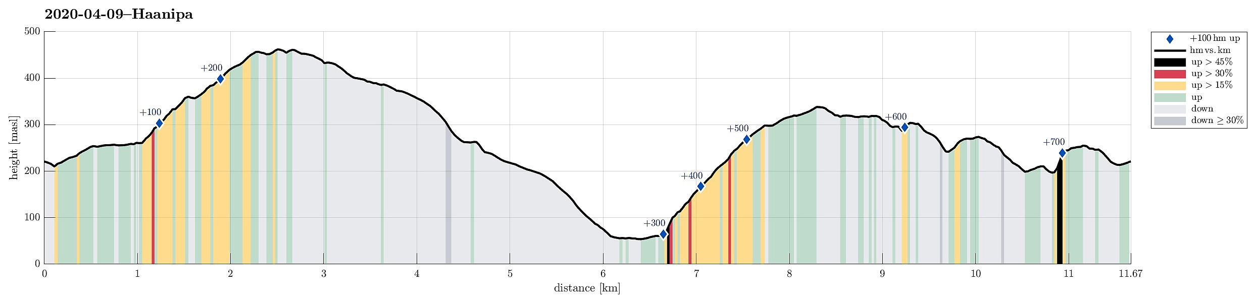
| Duration | 4h 15min |
| Distance | 11.7km |
| Vertical meters | 733m |
| GPS |
|
| Ascents | Erstadfjellet (465m) | 09.04.2020 |
|---|---|---|
| Hånipa (346m) | 09.04.2020 | |
| Visits of other PBEs | Askeland parkering (240m) | 09.04.2020 |
| Vest for Erstadfjellet (440m) | 09.04.2020 |
Trip Summary
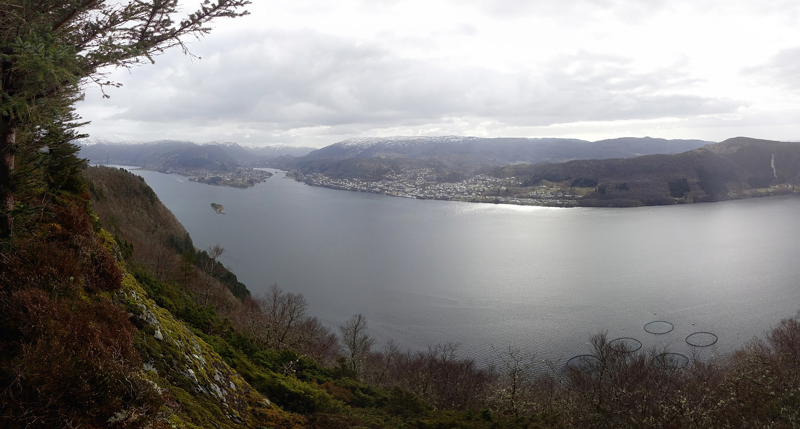
Trying to find a good spot for social distancing in this "special year" 2020, we aimed at the very west of Osterøy. The one little height, which we still had on our wish-list, Hånipa, with its apparently very steep western side, attracted us (for a longer time already) with a promise of nice views down to Sørfjorden. To make this a nice round, we parked near Askeland, about 200 height-meters above Votlo. From there, we first walked into Askelandsdalen (in eastern direction), before ascending relatively steeply to Setleitet (with some nice views down to Askelandsvatnet on the other side). Turning left, we started our ascent to Erstadfjellet (via Merkjedalsstølen). Crossing over Erstadfjellet, and only spending a few minutes up there to enjoy some nice views across Sørfjorden (mostly in southern, southwestern direction), we continued towards a little vista-point (west of Erstadfjellet), before turning in northern direction and following the ridge into the direction of Stormyrshædna. From there, the descent became a little steeper (no issue at all!), bringing us to a little saddle at about 260mosl. Turning left (in southwestern direction), we chose to cross Revskaret in order to get to a forest road that continues northwards through Reigstaddalen. Walking down this forest road, we ended up at Reigstadflaten, just a little south of Valestrand. Instead of actually entering Valestrand, however, we connected via Reigstadvegen to the trail that leads up to Hånipa (finally!). This trail leads steeply upwards in southern direction, through an impressive forest first, before passing by a number of old buildings near Nedre Fjellet. The trail extends further upwards, meeting the pronounced ridge of Reigstadfjellet at Varden. There, right at the point, where the trail starts to flatten out a little, the hiker is welcome by a nice bench, which is located at a perfect viewpoint (views towards the northwest, out Sørfjorden). From there, one just needs to follow the gentle ridge upwards to get to Hånipa. Just before reaching the actual top of Hånipa, one passes by a power line, which is suspended all over Sørfjorden from there in one very long stretch. At Hånipa, even though it's not really a high mountain, one can enjoy impressive views down to Sørfjorden, some 300+ height meters more or less directly below! The ridge walk then continues with more nice views! Once "down" to about 320mosl, the trail swings sharply to the left (and into eastern direction, away from the fjord), following further down along an impressive stone wall. From the beginning, we had considered to not follow this trail there, but to try and find a crossing over Rosshaugen (south of Hånipa) and Jonsokhaugen (south of Rosshaugen). We thus crossed the stone wall at a place where this was reasonably possible. At once, we were engulfed in very dense and high-growing vegetation -- not an ideal place for proceeding speedily! Still, we found sufficient openings between trees and bushes, descending (in zig-zag manner) further towards Rosshaugen. At about 300mosl, we crossed over a gently saddle to get to Rosshaugen. There, however, we met a substantial fence, which was high enough to not make it straight-forward to cross it (without possibly doing some damage to it). We thus first walked along the fence on its western side (which is not 100% simple, since the fence is built very close to the very steep western flank of Rosshaugen). Fortunately, only some meters into this passage, we found a good place for crossing over the fence. On the eastern side of the fence it then was straight-forward and easy to ascend Rosshaugen. Close to the top of Rosshaugen, where the mountain on the western side of the fence becomes a little less steep, we found another suitable spot for crossing it. This brought us to the western side of Rosshaugen -- a place, where possibly not so very often tourists from Papue New Guinea gather for their well-known moonshine parties. Carefully choosing our route further down (to avoid getting into all-too-steep terrain), we descended in southeastern direction (diagonally along the southern flank of Rosshaugen) to get to the saddle that leads over to Jonsokhaugen. Avoiding another fence, however, we stayed on its western side, descending a little further down than the approximately 250mosl at the saddle. Proceeding, however, was straight-forward and swift and soon later we even got the impression of a marked trail leading across the northern ridge of Jonsokhaugen to its "top". Up there, we rounded the little building next to a mast, before following a trail down from there (mostly in eastern direction). This brought us down into Votladalen and to the same forest road, which we had reached via Revskaret already earlier (further north). In order to connect to Askeland, we inspected the comparably steep eastern side of this valley, wondering (a) where to cross the stream and (b) how to get up to Teigen. We first went a few meters further up in Votladalen, before using a simple bridge to cross over the stream. Since getting up to Teigen from there did not look trivial (very steep!), we first walked again southwards along this flank. At the point, where we came to another stone wall, running across Votladalen there, we decided to give the flank a try. Ascending was possible, but required the help of our hands. It's only 40 or 50 height meters up there, but finding a suitable spot of where to do it will likely make the difference between success and retreat. Once up at Teigen, however, the final stretch back to Askeland was almost romantic -- this little flat at intermediate heights, extending from Askeland in northwestern direction, is really a very nice place! Altogether, we returned very satisfied to the car!
Photos
Selected photos are available as Google photo album.
Useful Resources
See also the related FB-page Hiking around Bergen, Norway.
Petter Bjørstad has a useful page about Erstadfjellet and also web page WestCoastPeaks.com provides useful information about Stemmeseggi, Erstadfjellet, and Hånipa.
Web page UT.no from the Norwegian Trekking Association recommends a similar hike.


User comments