
Gaustadfjellet, Litlafjellet, Bårafjellet, Øyjordsfjellet (14.04.2017)

Written by HHauser (Helwig Hauser)

| Start point | Ådland (45m) |
|---|---|
| Endpoint | Ådland (45m) |
| Characteristic | Hillwalk |
| Duration | 3h 45min |
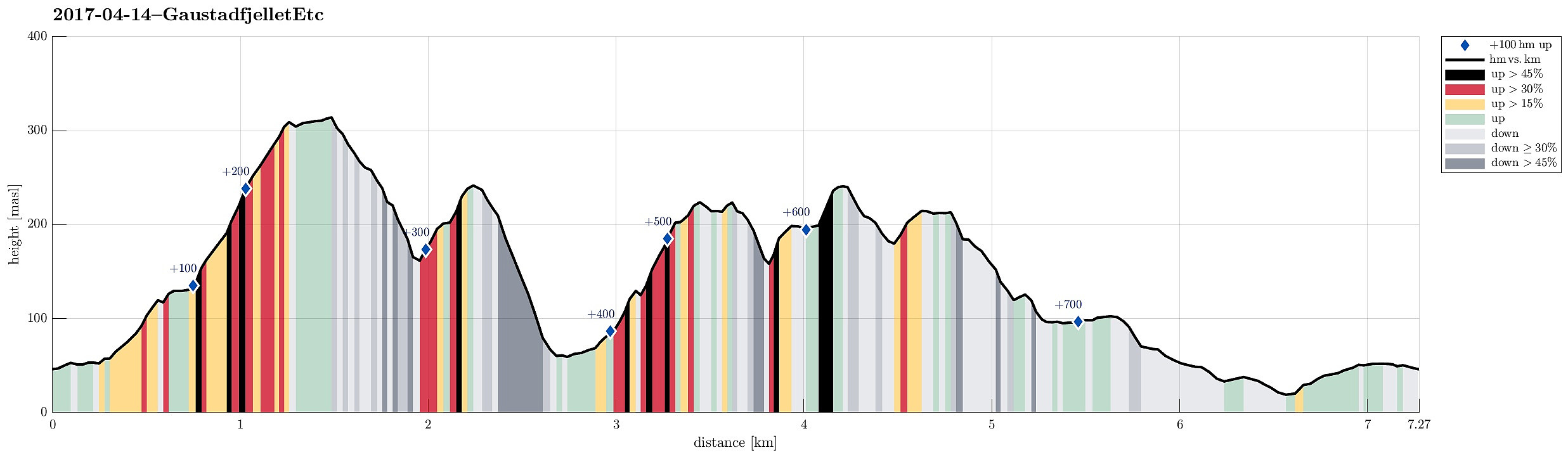
| Distance | 7.3km |
| Vertical meters | 756m |
| GPS |
|
| Ascents | Borefjell (227m) | 14.04.2017 |
|---|---|---|
| Gaustadfjellet (316m) | 14.04.2017 | |
| Litlafjellet (245m) | 14.04.2017 | |
| Øyjordsfjellet (243m) | 14.04.2017 |

Trip Summary
With a very promising spring day ahead, we decided to try some new top(s) in the north of Meland, i.e., Gaustadfjellet and others. We took road E39 northwards from Bergen, crossed Nordhordlandsbrua, and connected then to the small road #245 that departs from the road to Frekhaug right after the bridge to Meland. We then followed this narrow road northwards until we arrived at Ådland. We parked, where Kyrkjesundvegen departs in northern direction.
Gaustadfjellet
On the map, we had seen that approximately 200m south of this point, a path up to Gaustadfjellet should be possible to find---getting there, however, required a little bit of good orientation (and one more look at the map, actually). Once on this path, however, the ascent to Gaustadfjellet is straight-forward and quick. From the top of Gaustadfjellet, one can enjoy wonderful views in all directions---definitely a nice (not very high, but somewhat prominent) mountain to visit! :-)
Litlafjellet
From Gaustadfjellet, we already had the plan to connect to Litlafjellet, which is quite near in the northwest of Gaustadfjellet. We followed some small cairns into the direction of Litlafjellet from the top of Gaustadfjellet and recognized that the northwest face of Gaustadfjellet is clearly very steep. It's possible to descend on a relatively direct route between the tops (swinging back and forth a little, where possible), but it happened that we needed to use our hands in addition. If you are afraid of heights, this part is nothing for you. Once down in Litlaskaret between the two tops, the ascent to Litlafjellet on the other side was straight-forward (though also a bit steep).
Bårafjellet
Once on Litlafjellet, we decided that the day was simply to nice to not continue and thus we considered of how to get over to Bårafjellet. In fact, all the descent from Litlafjellet (in northwestern direction) was straight-forward and simple (also marked), so soon we arrived between the two mountains. There, we also stepped out onto a path, which leads in southern direction (to Kvernavatnet). We followed this path (only for a few meters), before another path took us into western direction (surrounding Bårafjellet first a little). Shortly after, we started our ascent to Bårafjellet (basically in northern direction). All the way up, there is a nice path, making this part of the hike straight-forward.
Øyjordsfjellet
Once on Bårafjellet, we enjoyed ourselves so much that we decided to continue even further, to Øyjordsfjellet. Instead of following the main path down from Bårafjellet (in northern direction), we found our way down in western direction without a path (not really difficult). On the other side, we first ascended to a little pre-top (west of Bårafjellet), before we continued towards the "main top" of Øyjordsfjellet from there (in northwestern direction). At times, one could guess that sometimes also others take this route (not many, for sure), but to call it a path is probably too much. In order to enjoy an as-clear-as-possible view to the north, we continued over "all the tops" of Øyjordsfjellet until we reached a spot on its northwestern side, marked with a small cairn.
Back via Mjåvatnet
From there, then, we decided to get back to our car, but we didn't like the idea to go back the same "path" that we had taken there before. So we thought that we could try to descend "directly" to Mjåvatnet underneath and then connect to the street from there. Not only because there clearly was no path, so also because the terrain proved to be quite steep there, this descent became a little more of an adventure than what is absolutely necessary. Especially in the middle-part, still high above Mjåvatnet, we needed to be very careful and choosing the right route downwards, avoiding some cliffs, was important. A short while later, we had made it down to Mjåvatnet and from there, it was straight-forward to connect to the road (to Ådlandsvegen) in eastern direction (passing Varden on its southern side).
Conclusion
All in all, this hike was really very, very nice---the perfect spring weather, with a lot of sun, made every moment enjoyable and we ended up with a lot of positive impressions, before getting back to the car. It maybe should be emphasized that even though these small tops are all not very high, the terrain is partially steep and requires careful stepping and a good choice of the route (in particular along the stretches, where there is no path or the "path" is hardly visible).
Photos
Selected photos are available as Google photo album.
Useful Resources
See also the related FB-page Hiking around Bergen, Norway.
Web page WestCoastPeaks.com provides useful information about Øyjordsfjellet, Borefjellet, Litlefjellet, and Gaustadfjellet and also Petter Bjørstad has a useful page about Gaustadfjellet and a useful page about Øyjordsfjellet.


User comments