
Flatafjellet from Helle (17.09.2016)

Written by HHauser (Helwig Hauser)

| Start point | Helle (25m) |
|---|---|
| Endpoint | Helle (25m) |
| Characteristic | Hillwalk |
| Duration | 5h 45min |
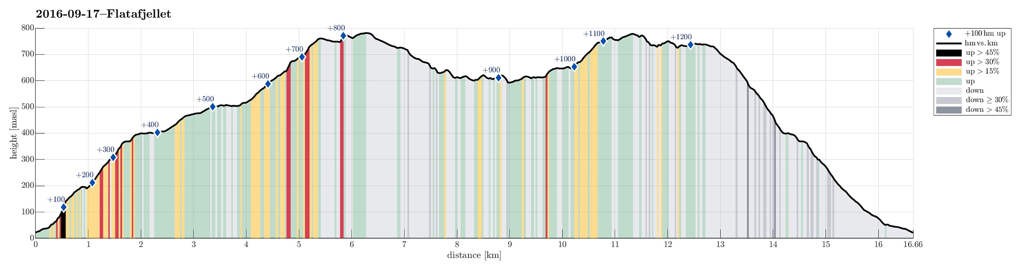
| Distance | 16.7km |
| Vertical meters | 1,216m |
| GPS |
|
| Ascents | Flatafjellet (784m) | 17.09.2016 |
|---|---|---|
| Flatavasshaugen (782m) | 17.09.2016 | |
| Visits of other PBEs | Fossmarksætra (604m) | 17.09.2016 |
| Vatnastølen (514m) | 17.09.2016 |
Trip Summary
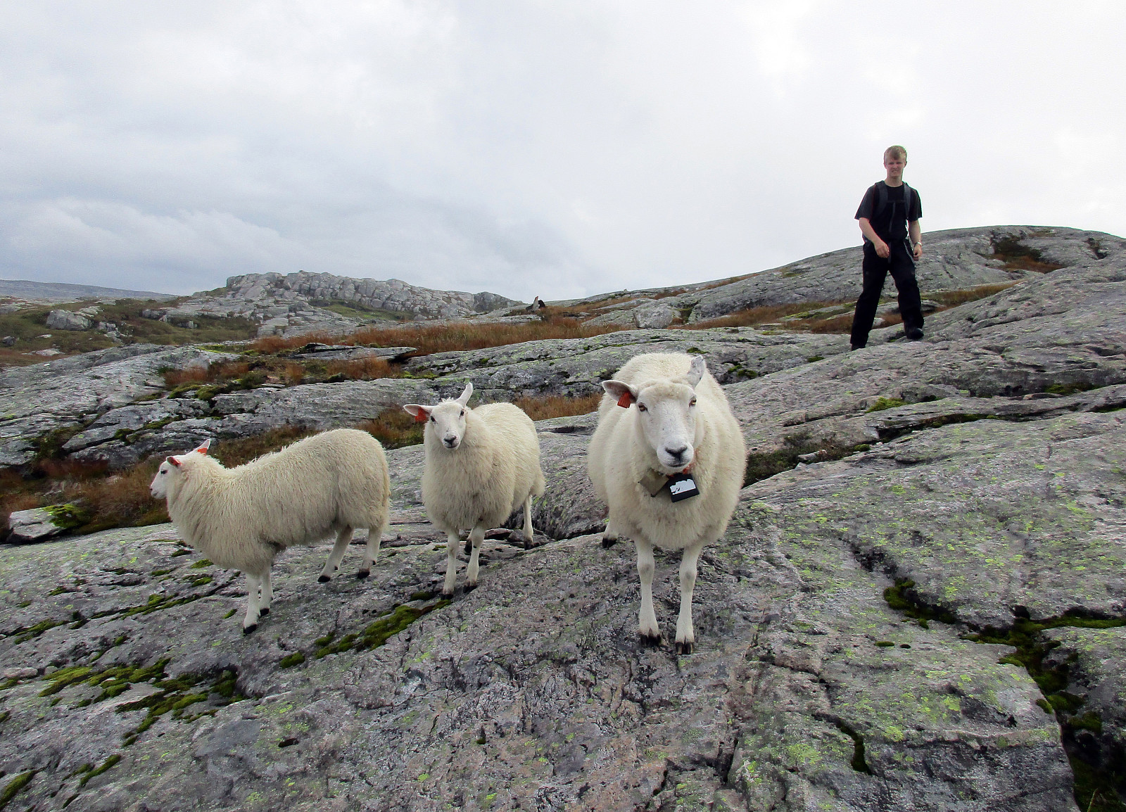
We took the E16 from Bergen towards Voss. Shortly after passing by Stanghelle, right after driving through Helletunnelen (and before entering Dalevågtunnelen), we left E16 to the left and continued on Sætravegen (for only few meters), which first goes parallel to E16, but then over it (over the tunnel-entry to Dalevågtunnelen) and to the other side. Driving Sætravegen up a little (to the to or three houses, there), we learned that it was not appreciated that we would park anywhere there---instead, we found a very good parking spot right next to E16 (but on its southeastern side). From there, we started walking, first Sætravegen up. At the upper end of the few houses, a trail leaves to the left. We took this trail, which leads one quickly upwards and into Espeligjelet (one could also take the forrest road---basically the continuation of Sætravegen---to get there). Nearby a place called Stadlane, he forrest road ends and a well-visible trail continues further up (near the end of the forrest road, we took a small detour to the left for enjoying some views over Helle, etc.). From Espelia, the path leads upwards, making a turn to the east, after a while, and to Tjørnamyra---someone has put a lot of effort into making this path a nice trail to step up---quite impressive! From Tjørnamyra it is not much further up to Hellestølen/Hellesætra. There, we needed to decide about which way to take---towards the right (and upwards) one major trail leads up to Flatafjellet, while further southwards, following the valley, basically, another path first leads to two/three lakes (Vatnastølvatnet, etc.), before connnecting to another path that leads up Flatafjellet ("from the backside"). We decided for the second option and reached Vatnastølvatnet after a few minutes of further hiking. Right "behind" Vatnastølvatnet (at Litlvatnet), the path split and we turned right and upwards towards Flatafjellet. Red markings lead the way up into Litlefossdalen, helping a lot with finding the right way up (since the path itself is basically non-existent, there). Stepping through Litlefossdalen is easy and straight-forward---but quite a bit wet! :-) At some point (about 630mosl), the path winds towards the right (north) and upwards. This way, one avoids getting into Trollabotnen (probably steep!), while turning towards Bergsmota (and towards the other path that comes up from Hellesætra). Instead of following the marked trail further up to Bergsmota, we continued (without path) towards the west (and towards the supposedly highest point on Flatafjellet). We came to some slightly larger water and walked along it on its southeastern side, before ascending further up. At the small top, which we reached then, we got the impression that a neighboring small top (further north) was slightly higher. In order to get there, we needed to cross over a comparably deep trench (only a few meters down, but so steep that a little back and forth was necessary to find a spot, which allowed to get over to the other side). Once there, we quickly continued to "the top of Flatafjellet" (also according to the map, then). From there, we thought to get a view of Sørfjorden/Veafjorden. The topography of Flatafjellet (steep sides, extended top-region---not flat, though!) required that we started a longer detour---from "the top of Flatafjellet" towards the southwest in the vicinity of Kraksånuten, and the back along the red-marked tail that connects to Hellesætra. The first part of this detour, while still relatively high up, was easy and straight-forward. Then, when coming closer to Kraksåvatnet (from the northeast), it became steeper and more careful stepping was necessary. At last, before reaching Kraksåvatnet, we ended up at the top of a cliff (right above Kraksåvatnet). There, we searched a bit to the left and right, before we found a continuation (towards the north of Kraksåvatnet). We crossed the red-marked trail, which also passes by north of Kraksåvatnet, crossed another small hill, north of Kraksåvatnet, before we got back to the marked trail. For a short distance, we then followed this trail---basically, until we came close to the few huts, which are set up west of Sætratjørna. From there, we continued a bit (off-trail) further in northwestern direction, to find a good vantage point with a view of the fjord underneath. We considered to continue all to way towards Kraksånuten, but decided, then, to return, instead, and hike back to Hellesætra. Accordingly, we stepped back down to the red-marked trail and continued along it until we were back "on the top of Flatafjellet" (another top, though). After hiking up through Tjørndalen and Botnagjela (along the red-marked trail), we came to a small top with a great view over Flatavatnet in the north. From there, it then was only a few meters down to the point, where the path towards Hellesætra splits from the one, which connects to Litlefossdalen (where we had hiked up). We followed this path for a few meters, before leaving the path, again, and ascending to Flatavasshaugen---almost as high as "the top of Flatafjellet". From looking at the map (the evening before the hike), we assumed that it should be easy and straight-forward to connect back to the red-marked trail (the one to Hellesætra) after crossing Flatavasshaugen in northeastern direction. Quickly, we found out that Flatavasshaugen is significantly steep on all of its northwestern, northern, and northeastern sides. We ended up quite a bit above Botnavatnet (with great views from there!). Eventually, we found a narrow diagnoal, which enabled us to get down safely. We then crossed over (in western direction and south of Botnavatnet), finding the red-marked tail soon after on the opposite hillside. Not far from there, however, it again became challenging: Where Middagsgjela comes up from the north, the ridge along which the red-marked trail extends is substantially structured, with rockfaces a few meters up and down (you really need to find the special spots, where a continuation is possible). With a bit of careful path-finding, we followed the red-marked trail pretty accurately and soon after hiking became easier, again (while the trail is---in principle---very well marked, it's not in all places straight forward to find the next mark). Step by step, we then started our descend over the long ridge north of Botnagjelet, including Tjørnhaugane and Blomtrekkena. At Hellsætra, we conntected back to the path, which we had taken up, and we followed it down, again, until we met the forrest road at Stadlane. Then, instead of hiking down the trail, which we had taken up, we simply walked down the forrest road and then Sætravegen back to our car. All in all, we made a few conclusions, after the hike: First, it became very clear, after all, that Flatafjellet is not really flat (it's not so clear, though, which of the many small tops of Flatafjellet, is the highest one). Then, it is certainly so that hiking Flatafjellet is by no means boring---instead, one gets repeatedly surpirsed about how challenging the terrain is in certain locations (in particular, when hiking off-trail). Last, it is not so easy to enjoy extended fjord-views from Flatafjellet (due to its topography)---at least not, without hiking quite a bit extra to get to the "edge" of the extended top of this mountain (maybe the mainn reason for the name?).
Photos
Selected photos are available as Google photo album.
Useful Resources
See also the related FB-page Hiking around Bergen, Norway.
Web page WestCoastPeaks.com provides useful information about Flatafjellet.
Web page UT.no from the Norwegian Trekking Association shows parts of this hike as a marked hiking-route (on the map on UT.no).


User comments