
Kanadaskogen with Knappen, Svartaberget, etc. (28.05.2016)

Geschrieben von HHauser (Helwig Hauser)

| Startpunkt | Varden (45m) |
|---|---|
| Endpunkt | Varden (45m) |
| Tourcharakter | Bergtour |
| Tourlänge | 3h 00min |
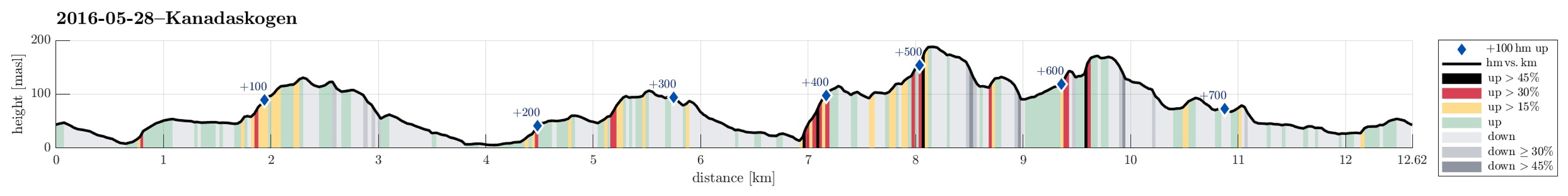
| Entfernung | 12,6km |
| Höhenmeter | 750m |
| GPS |
|
| Besteigungen | Eldtona (128m) | 28.05.2016 |
|---|---|---|
| Knappen (135m) | 28.05.2016 | |
| Storhovden (174m) | 28.05.2016 | |
| Straumsfjellet (111m) | 28.05.2016 | |
| Svartaberget (194m) | 28.05.2016 | |
| Træshovden (119m) | 28.05.2016 | |
| Besuche anderer PBE | Storhovden utsiktspunkt (172m) | 28.05.2016 |
Trip Summary
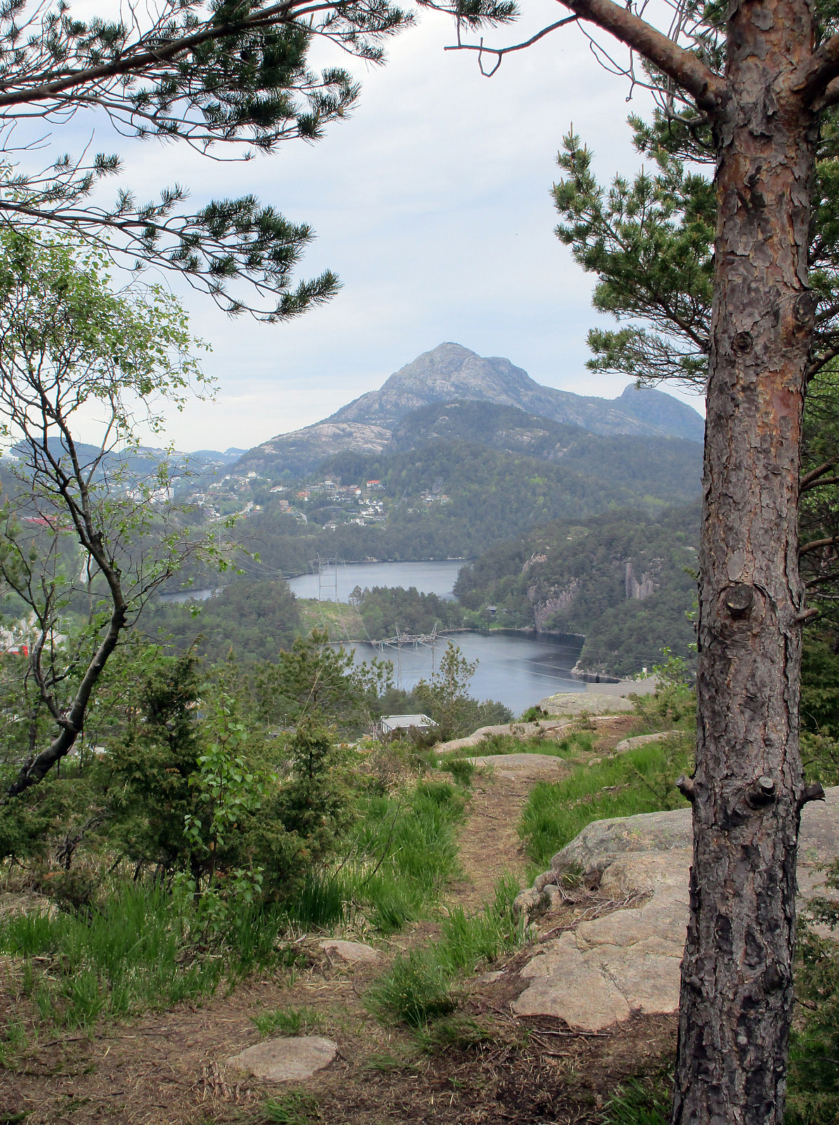
Starting at Varden in Fyllingsdalen, I first got over and up to Knappen (around Knappatjørna). From Knappen, I continued to Eldtona and further over the top and down again to Bjørgelien. Following that street downwards, I got to Bjøgeveien in order to cross over Kjerreidvika to Bjørndalsskogen (right behind the supermarked along Kjerreidvika there is a steep path that leads up to Bjørndalsskogen). I then crossed the living area at Bjørndalsskogen, before ascending to Straumsfjellet, right north of Bjørndalsskogen. From Straumsfjellet, I found a path down to Bjørndalsbrotet, where I crossed underneath Bjørgeveien over to Kanadaskogen. I continued towards Bjørndalsvatnet, first, getting into the green area as soon as possible. Without really entering the path that rounds about Bjørndalsvatnet in the north, I decided to start ascending along the steep ridge (heading north), which separates Kanadaskogen from Sæterdal. I continued over the top of the ridge into the direction of Svartaberget (right along this stretch, I crossed over Ravnestølen, which has a few houses that overlook Kanadaskogen from up there). The last bit up Svartaberget is steep, but good to step up. From Svartaberget, one can enjoy nice views in south-western direction. I continued from the top, first in northern direction, then taking a larger quarter-circle in order to get down to the saddle that separates Svartaberget from nearby Kanadaskogen-tops northeast of Svartaberget. Over a few of the minor tops in this area, I continued towards east from there---heading for Storhovden. Doing so, I crossed Storamyra (with some good views to the big rock that sits right about Storamyra). I then ended up ascending towards Storhovden from the west (without a path and quite steep up, actually). From Storhovden, I continued southwards, via Syningen, towards Krokatjørna. From there, I took a small path that leads towards Hesjaholtet, and from there, I simply stepped back to Varden along one of the many small paths there. Eventually, this was a slightly longer hike than originally anticipated, but definitely good in order to get some fresh air and do a bit of exercise.
Photos
Selected photos are available as Google photo album.
Useful Resources
See also the related FB-page Hiking around Bergen, Norway.
Petter Bjørstad has a useful page about Knappen.
Web page TurStier.org describes a similar hike.


Benutzerkommentare