Archive - Date
Archive - Activity
-
Bike trip (110)
- Bike trip - mixed (25)
- Bike trip - road (85)
-
Drive (9)
- Car drive (9)
-
Other trip (3)
- Kayaking (3)
-
Ski trip (116)
- Backcountry skiing (69)
- Cross-country skiing (47)
- Trip by foot (1884)
Collected lists
-
Utvalgte topper og turmål i Bergen
(348/349)
 99%
99% -
Alle topper i Bergen
(391/398)
98%
-
Voss ≥ 100m pf.
(96/98)
97%
-
Opptur Hordaland
(144/159)
90%
-
Stasjoner på Bergensbanen
(33/40)
82%
-
Ulvik ≥ 100m pf.
(28/38)
73%
-
Hordaland ≥ 100m pf.
(622/863)
72%
-
Mjølfjell PF > 100m
(21/31)
67%
-
Jondal ≥ 100m pf.
(15/23)
65%
-
Dagsturhyttene i Vestland
(36/61)
59%
-
Sunnhordland PF >= 100m
(105/186)
56%
-
Hordaland: Hardanger PF>=100m
(194/359)
54%
-
DNT-hytter i Hordaland
(23/45)
51%
-
Kvinnherad ≥ 100m pf.
(40/79)
50%
-
Eidfjord ≥ 100m pf.
(13/42)
30%
-
Sogndal ≥ 100m pf.
(23/81)
28%
-
Gulen ≥ 100m pf.
(15/54)
27%
-
Vik i Sogn ≥ 100m pf.
(10/46)
21%
-
Sogn - Sør for Sognefjorden PF>=100m
(31/159)
19%
-
DNT-hytter i Sogn og Fjordane
(8/47)
17%

Byrkjefjellet and Iendafjellet
- Date:
- 19.08.2018
- Characteristic:
- Hillwalk
- Duration:
- 5:47h
- Distance:
- 16.8km
 Byrkjefjellet
Started by taking the bus to Kvamskogen and getting off at the bus stop Wallemtunet. From there I followed the gravel road northwest, looking for one of the many trailheads indicated on the map. As far as I could see there were no marked trails for Byrkjefjellet (or any other locations for that matter) and the ones I looked at were all equally wet. This did however greatly improve as the trail turned north. Here it also connected with another trail coming up from the south (which I decided to try on the descent).
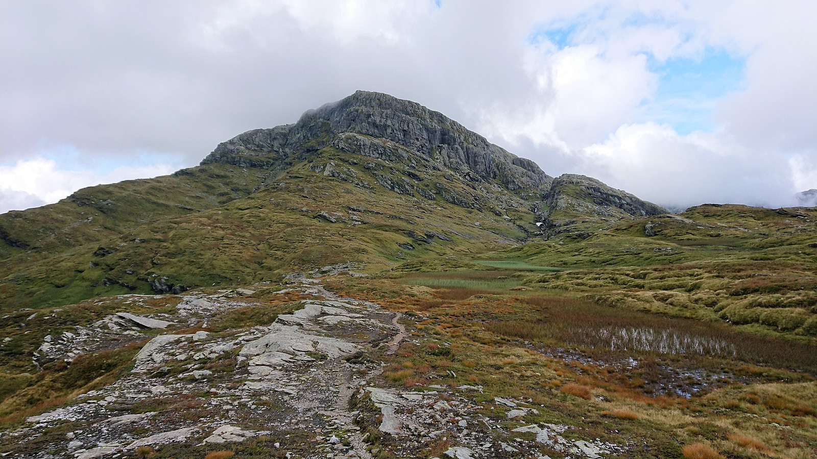
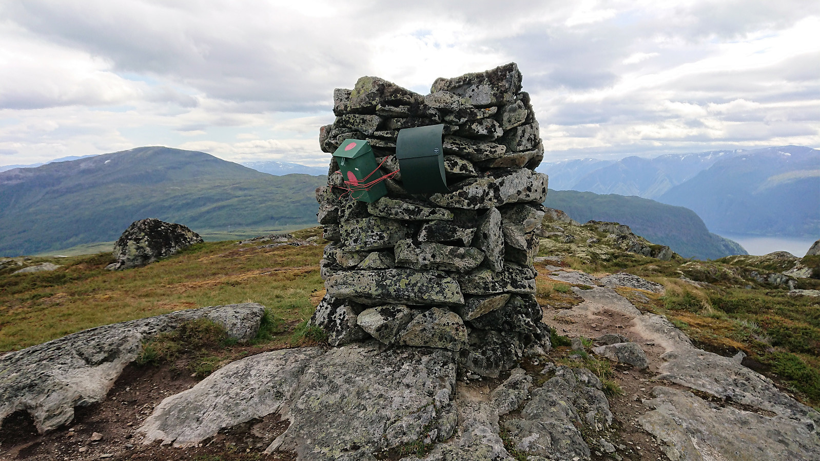
From here, the trail was overall easy to follow until reaching the small cairn southeast of the 996 hill south of the summit, which provided very nice views. The summit itself was however further north, and, as far as I could tell, blocked by a cliff. I knew there was supposed to be >>>
Byrkjefjellet
Started by taking the bus to Kvamskogen and getting off at the bus stop Wallemtunet. From there I followed the gravel road northwest, looking for one of the many trailheads indicated on the map. As far as I could see there were no marked trails for Byrkjefjellet (or any other locations for that matter) and the ones I looked at were all equally wet. This did however greatly improve as the trail turned north. Here it also connected with another trail coming up from the south (which I decided to try on the descent).
From here, the trail was overall easy to follow until reaching the small cairn southeast of the 996 hill south of the summit, which provided very nice views. The summit itself was however further north, and, as far as I could tell, blocked by a cliff. I knew there was supposed to be >>>
Hodnakletten and Myrsfjellet
- Date:
- 15.08.2018
- Characteristic:
- Hillwalk
- Duration:
- 3:40h
- Distance:
- 13.0km
 Hodnakletten
After reading several trip reports talking about coming across a marked trail on their way to Hodnakletten , I decided to do some digging and found this suggested hike at ut.no: Hodnekletten frå byggefeltet på Myking , referring to a marked trail with wet areas that could be followed all the way to the western summit of Hodnakletten. So I decided to give it a try.
Started by taking the bus to Myking, getting off at the last stop referred to as "Myking, butikken", and from there found my way to the trailhead indicated in the above trip suggestion. As detailed at ut.no, the trail started right to the west of the last house on the north side of the road, and I walked up the short gravel road next to the house hoping to there locate the start of a trail.
But instead of an easy to follow tractor road (which is what was indicated >>>
Hodnakletten
After reading several trip reports talking about coming across a marked trail on their way to Hodnakletten , I decided to do some digging and found this suggested hike at ut.no: Hodnekletten frå byggefeltet på Myking , referring to a marked trail with wet areas that could be followed all the way to the western summit of Hodnakletten. So I decided to give it a try.
Started by taking the bus to Myking, getting off at the last stop referred to as "Myking, butikken", and from there found my way to the trailhead indicated in the above trip suggestion. As detailed at ut.no, the trail started right to the west of the last house on the north side of the road, and I walked up the short gravel road next to the house hoping to there locate the start of a trail.
But instead of an easy to follow tractor road (which is what was indicated >>>
Anekletten, Jurfedthaugen and Vikåsen
- Date:
- 14.08.2018
- Characteristic:
- Hillwalk
- Duration:
- 3:21h
- Distance:
- 12.8km
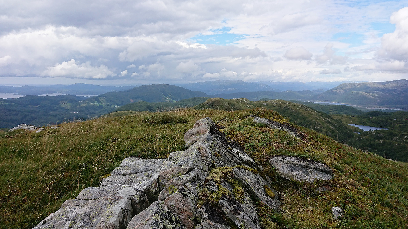
 Started by taking the bus to Stegavika and from there walking north along the road until turning east at Norlavatnet. We were now on Nordsjøløypa, which could easily be followed all the way to the summit of Anekletten . Anekletten provided excellent views, especially given that we were only 60 meters above sea level.
From the summit we continued west to the main road and then south along Toftevågen, and finally west towards the remains of the old wave power plant at Kalvøyna. Here we had a quick lunch break before taking a closer look at what was left of the power plant. Next, we headed south for a quick visit to Jurfedthaugen .
Upon reaching the road we followed it shortly northeast, before heading north, and later west, along the marked trail to Vikåsen . Also here the views were very nice, despite being even lower than >>>
Started by taking the bus to Stegavika and from there walking north along the road until turning east at Norlavatnet. We were now on Nordsjøløypa, which could easily be followed all the way to the summit of Anekletten . Anekletten provided excellent views, especially given that we were only 60 meters above sea level.
From the summit we continued west to the main road and then south along Toftevågen, and finally west towards the remains of the old wave power plant at Kalvøyna. Here we had a quick lunch break before taking a closer look at what was left of the power plant. Next, we headed south for a quick visit to Jurfedthaugen .
Upon reaching the road we followed it shortly northeast, before heading north, and later west, along the marked trail to Vikåsen . Also here the views were very nice, despite being even lower than >>>
Kolåsfjellet, Lyngfjellet and Skausnøya
- Date:
- 11.08.2018
- Characteristic:
- Hillwalk
- Duration:
- 3:56h
- Distance:
- 16.8km
 Kolåsfjellet
Started by taking the bus to Lindås and getting off at the bus stop called "Lindås senter". From there I followed what seemed like the most direct route towards Kolåsfjellet and shortly came across the first sign indicating the path to the summit. First along a gravel road and later along what I guess can be called a gravel-covered trail. Overall very easy access. The summit provided very nice views, in particular towards the north and east.
After a short break I returned to Lindås and continued southeast towards my next goal of Lyngfjellet . Thankfully it was possible to walk along the old road, where there was very limited traffic compared the new road right next to it.
Lyngfjellet and an unexpected roundtrip
From the map, ascending Lyngfjellet seemed fairly straightforward, with a road going >>>
Kolåsfjellet
Started by taking the bus to Lindås and getting off at the bus stop called "Lindås senter". From there I followed what seemed like the most direct route towards Kolåsfjellet and shortly came across the first sign indicating the path to the summit. First along a gravel road and later along what I guess can be called a gravel-covered trail. Overall very easy access. The summit provided very nice views, in particular towards the north and east.
After a short break I returned to Lindås and continued southeast towards my next goal of Lyngfjellet . Thankfully it was possible to walk along the old road, where there was very limited traffic compared the new road right next to it.
Lyngfjellet and an unexpected roundtrip
From the map, ascending Lyngfjellet seemed fairly straightforward, with a road going >>>
Stongfjellet from Lonevåg
- Date:
- 09.08.2018
- Characteristic:
- Hillwalk
- Duration:
- 3:43h
- Distance:
- 14.6km
 Started by taking the bus two or three stops passed Lonevåg terminal to the bus stop referred to as both "Hatland skulesenter" and "Hatland US". From there I followed the roads southeast to locate the marked trailhead between Byrkjeland and Hovdo. The second half of this walk included a steady almost 200 meters climb spread over 2 km, reaching just below 250 meters above sea level before starting the real hike.
The trail started out wet and muddy. The fact that started raining did not help much either. However, within not too long the quality of the trail improved as it started to climb more steeply, and halfway up the mountain it thankfully also stopped raining. (The rain would return on the descent, but less intense). Not long after I passed by two small cabins and soon >>>
Started by taking the bus two or three stops passed Lonevåg terminal to the bus stop referred to as both "Hatland skulesenter" and "Hatland US". From there I followed the roads southeast to locate the marked trailhead between Byrkjeland and Hovdo. The second half of this walk included a steady almost 200 meters climb spread over 2 km, reaching just below 250 meters above sea level before starting the real hike.
The trail started out wet and muddy. The fact that started raining did not help much either. However, within not too long the quality of the trail improved as it started to climb more steeply, and halfway up the mountain it thankfully also stopped raining. (The rain would return on the descent, but less intense). Not long after I passed by two small cabins and soon >>>
Totlandsfjellet/Ørnakulten from Eknes
- Date:
- 08.08.2018
- Characteristic:
- Hillwalk
- Duration:
- 1:24h
- Distance:
- 5.0km
 Started by taking the bus to Eknes and the bus stop called "Eknes, butikken". Did not see any traces of the store the name of the bus stop referred to though. It should also be mentioned that the bus from Knarvik to Eknes follows all the minor roads and crosses multiple bridges with room for only one vehicle at the time. Hence progress was very slow. On the other hand, plenty of time for sightseeing.
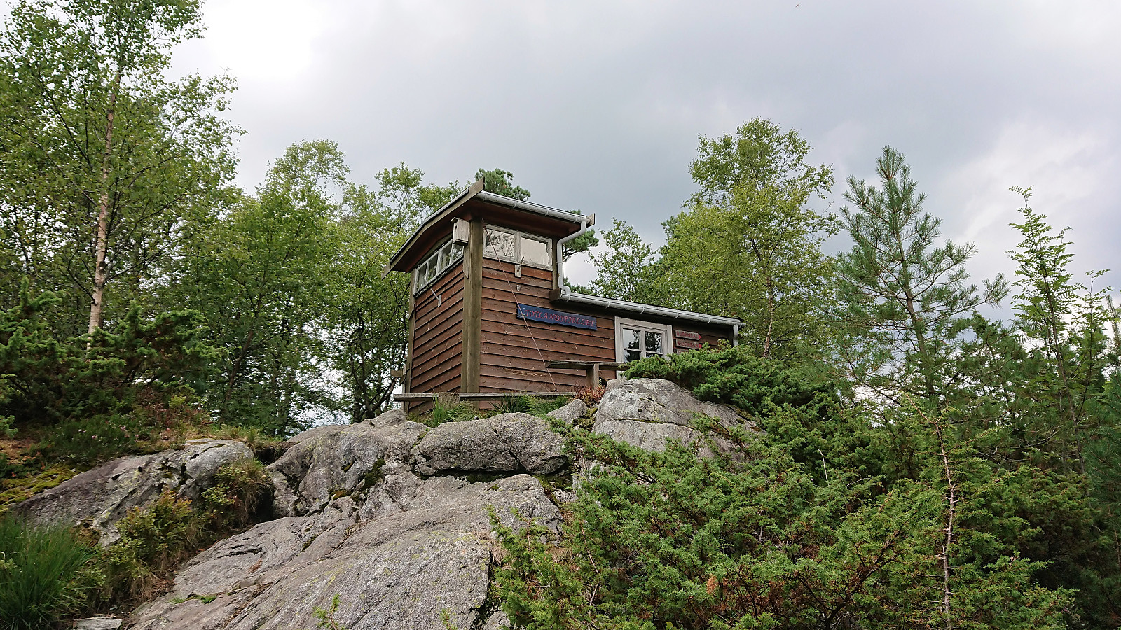
From the bus stop I walked up to the main road where I, after crossing the road, arrived at the marked trailhead for Totlandsfjellet/Ørnakulten . The trail was then easily followed all the way to the summit. Clearly lots of work had gone into the making of this trail, with numerous (almost too many?) small wooden bridges to step on.
The visitor register was located inside a small cabin which also had its own lookout >>>
Started by taking the bus to Eknes and the bus stop called "Eknes, butikken". Did not see any traces of the store the name of the bus stop referred to though. It should also be mentioned that the bus from Knarvik to Eknes follows all the minor roads and crosses multiple bridges with room for only one vehicle at the time. Hence progress was very slow. On the other hand, plenty of time for sightseeing.
From the bus stop I walked up to the main road where I, after crossing the road, arrived at the marked trailhead for Totlandsfjellet/Ørnakulten . The trail was then easily followed all the way to the summit. Clearly lots of work had gone into the making of this trail, with numerous (almost too many?) small wooden bridges to step on.
The visitor register was located inside a small cabin which also had its own lookout >>>
Geitanuken from Morvik
- Date:
- 07.08.2018
- Characteristic:
- Hillwalk
- Duration:
- 3:00h
- Distance:
- 12.5km
 Change of plans...
My initial plan to go hiking to new peaks in Lindås had to be abandoned as the bus to Knarvik never showed up at Handelshøyskolen. I therefore jumped on the next bus heading to Åsane and came up with the alternative plan of instead ascending Geitanuken from the south/southwest, as the map showed a trail there that I had not yet tried.
Geitanuken
Left the bus at Viddalen and followed Farbotslia east towards where the start of a trail was indicated on the map. Did not find a marked trailhead, but just west of Morvikbotn 258 I came across a small gate and what looked like a potential trail on the other side. Shortly after passing through the gate the trail started climbing, at times relatively steeply, there were even a couple of ropes, although these were most often not really needed.
Change of plans...
My initial plan to go hiking to new peaks in Lindås had to be abandoned as the bus to Knarvik never showed up at Handelshøyskolen. I therefore jumped on the next bus heading to Åsane and came up with the alternative plan of instead ascending Geitanuken from the south/southwest, as the map showed a trail there that I had not yet tried.
Geitanuken
Left the bus at Viddalen and followed Farbotslia east towards where the start of a trail was indicated on the map. Did not find a marked trailhead, but just west of Morvikbotn 258 I came across a small gate and what looked like a potential trail on the other side. Shortly after passing through the gate the trail started climbing, at times relatively steeply, there were even a couple of ropes, although these were most often not really needed.
Bjedlastølen
- Date:
- 03.08.2018
- Characteristic:
- Hillwalk
- Duration:
- 3:19h
- Distance:
- 14.2km
 Rain and fog meant that heading for a new summit would be a bit of a waste this evening. I therefore decided on a visit to Bjedlastølen instead. I started from Fjøra and from there walked along the roads to Bjella, where I easily located the marked trailhead. I then passed by multiple gates on the way up to Bjedlastølen. First on a tractor road and later on a rather wet trail.
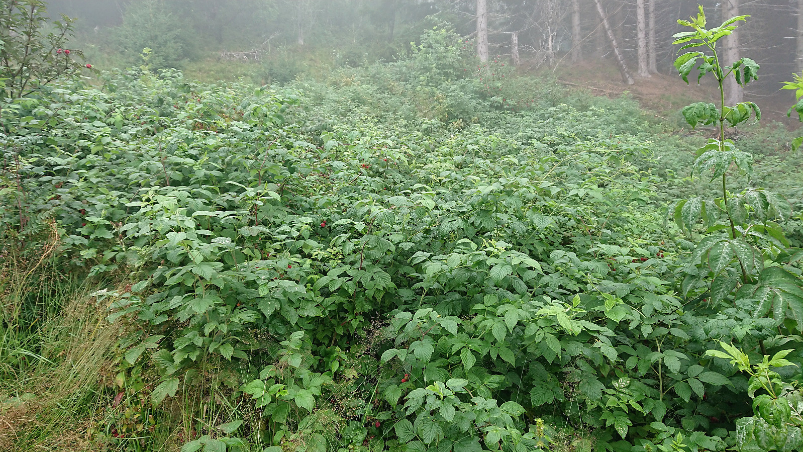
The positive surprise was the endless amounts of wild raspberries! Just before reaching Bjedlastølen I was also surprised by several cows appearing in the fog. None of them seemed to pay me any attention though. From Bjedlastølen I could also spot 2-3 horses in the distance and on the decent I came across numerus sheep.
Shortly after leaving Bjedlastølen a new sign appeared. Or rather two signs: Åberge 2.4 and 2.9 km. I chose >>>
Rain and fog meant that heading for a new summit would be a bit of a waste this evening. I therefore decided on a visit to Bjedlastølen instead. I started from Fjøra and from there walked along the roads to Bjella, where I easily located the marked trailhead. I then passed by multiple gates on the way up to Bjedlastølen. First on a tractor road and later on a rather wet trail.
The positive surprise was the endless amounts of wild raspberries! Just before reaching Bjedlastølen I was also surprised by several cows appearing in the fog. None of them seemed to pay me any attention though. From Bjedlastølen I could also spot 2-3 horses in the distance and on the decent I came across numerus sheep.
Shortly after leaving Bjedlastølen a new sign appeared. Or rather two signs: Åberge 2.4 and 2.9 km. I chose >>>
Lusaskard from Øvstedalen
- Date:
- 01.08.2018
- Characteristic:
- Hillwalk
- Duration:
- 4:05h
- Distance:
- 15.5km
 After our previous recent visit to Øvstedalen we had studied the map and located another potential parking lot further up the valley. This time we therefore paid the toll (30 kr for one day) just next to the lower parking lot and then continued northwest up Gardselvegen. At the first crossroads we went right and then through a gate before turning north up a relatively steep hill to arrive at the parking lot indicated on the map .
The parking lot provided a marked trailhead for Fjærlandsete (and more), clearly indicating that we were on the right track (unlike for our previous attempt). No signs for Lusaskard yet, but these would show up later. The trail was easy to follow, but did contain its fair share of wet areas until reaching Furesete.
Upon reaching Kalvavatnet I left the rest of my party behind for blueberry picking and continued on my own towards Lusaskard. Again the >>>
After our previous recent visit to Øvstedalen we had studied the map and located another potential parking lot further up the valley. This time we therefore paid the toll (30 kr for one day) just next to the lower parking lot and then continued northwest up Gardselvegen. At the first crossroads we went right and then through a gate before turning north up a relatively steep hill to arrive at the parking lot indicated on the map .
The parking lot provided a marked trailhead for Fjærlandsete (and more), clearly indicating that we were on the right track (unlike for our previous attempt). No signs for Lusaskard yet, but these would show up later. The trail was easy to follow, but did contain its fair share of wet areas until reaching Furesete.
Upon reaching Kalvavatnet I left the rest of my party behind for blueberry picking and continued on my own towards Lusaskard. Again the >>>
Storehaugen and Storehaugfjellet
- Date:
- 29.07.2018
- Characteristic:
- Hillwalk
- Duration:
- 5:27h
- Distance:
- 18.0km
 We parked at the small parking lot next to Flyplassvegen and followed the marked trail via Bjørkestølen , including a stop at Storehaugen on the way to Storehaugfjellet . Storehaugen provided spectacular views in all directions. Well worth a visit even though Storehaugfjellet is the slightly higher of the two.
After a break for lunch at Storehaugfjellet, it was decided to follow the gravel road southwest (and later east) down to the airport at Haukåsen and from there walk along the road back to the car. But while this did make the hike into a roundtrip, it cannot really be recommended, as it ends with a rather long and boring walk with limited views.
Probably better to either return the same way, or via the alternative route following the ridge back to the parking lot. An additional option would be to use two cars. Just make sure to not repeat the mistake of one family >>>
We parked at the small parking lot next to Flyplassvegen and followed the marked trail via Bjørkestølen , including a stop at Storehaugen on the way to Storehaugfjellet . Storehaugen provided spectacular views in all directions. Well worth a visit even though Storehaugfjellet is the slightly higher of the two.
After a break for lunch at Storehaugfjellet, it was decided to follow the gravel road southwest (and later east) down to the airport at Haukåsen and from there walk along the road back to the car. But while this did make the hike into a roundtrip, it cannot really be recommended, as it ends with a rather long and boring walk with limited views.
Probably better to either return the same way, or via the alternative route following the ridge back to the parking lot. An additional option would be to use two cars. Just make sure to not repeat the mistake of one family >>>
