Archiv - Nach Datum
Archiv - Nach Aktivität
-
Andere Tour (3)
- Kayaking (3)
-
Fahrradtour (111)
- Fahrradtour Straße (86)
- Fahrradtour gemischt (25)
-
Fahrzeugtour (9)
- Autotour (9)
-
Fußtour (1897)
- Bergtour (1120)
- Jogging (1)
- Spaziergang (60)
- Wanderung (716)
-
Skitour (116)
- Langlauf (47)
- Tourenskilauf (69)
Gesammelte Listen
-
Utvalgte topper og turmål i Bergen
(349/351)
 99%
99% -
Alle topper i Bergen
(393/400)
98%
-
Voss ≥ 100m pf.
(96/98)
97%
-
Opptur Hordaland
(144/159)
90%
-
Stasjoner på Bergensbanen
(33/40)
82%
-
Ulvik ≥ 100m pf.
(30/38)
78%
-
Hordaland ≥ 100m pf.
(624/863)
72%
-
Mjølfjell PF > 100m
(21/31)
67%
-
Jondal ≥ 100m pf.
(15/23)
65%
-
Dagsturhyttene i Vestland
(36/61)
59%
-
Sunnhordland PF >= 100m
(105/186)
56%
-
Hordaland: Hardanger PF>=100m
(196/359)
54%
-
DNT-hytter i Hordaland
(23/45)
51%
-
Kvinnherad ≥ 100m pf.
(40/79)
50%
-
Eidfjord ≥ 100m pf.
(13/42)
30%
-
Sogndal ≥ 100m pf.
(23/81)
28%
-
Gulen ≥ 100m pf.
(15/54)
27%
-
Vik i Sogn ≥ 100m pf.
(10/46)
21%
-
Sogn - Sør for Sognefjorden PF>=100m
(31/159)
19%
-
DNT-hytter i Sogn og Fjordane
(8/47)
17%

Hellen festning with Endre!
- Datum:
- 09.02.2025
- Tourcharakter:
- Spaziergang
- Tourlänge:
- 0:11h
- Entfernung:
- 0,4km
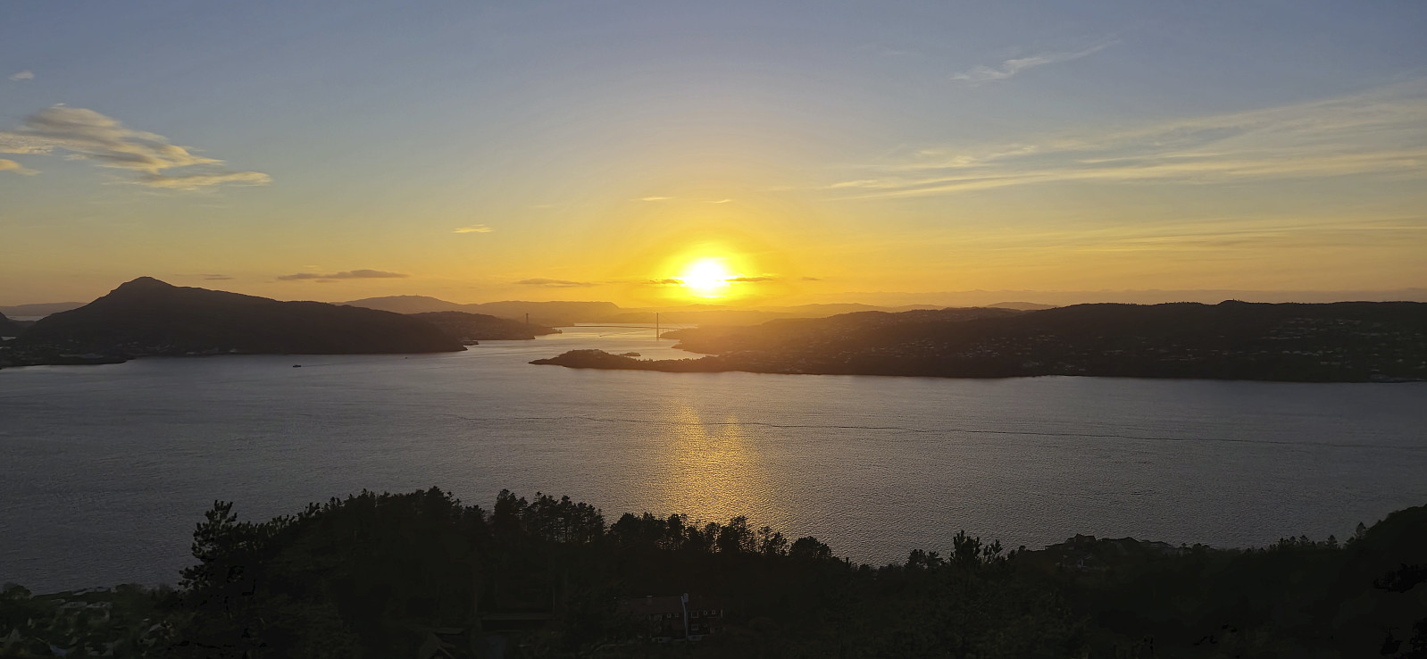
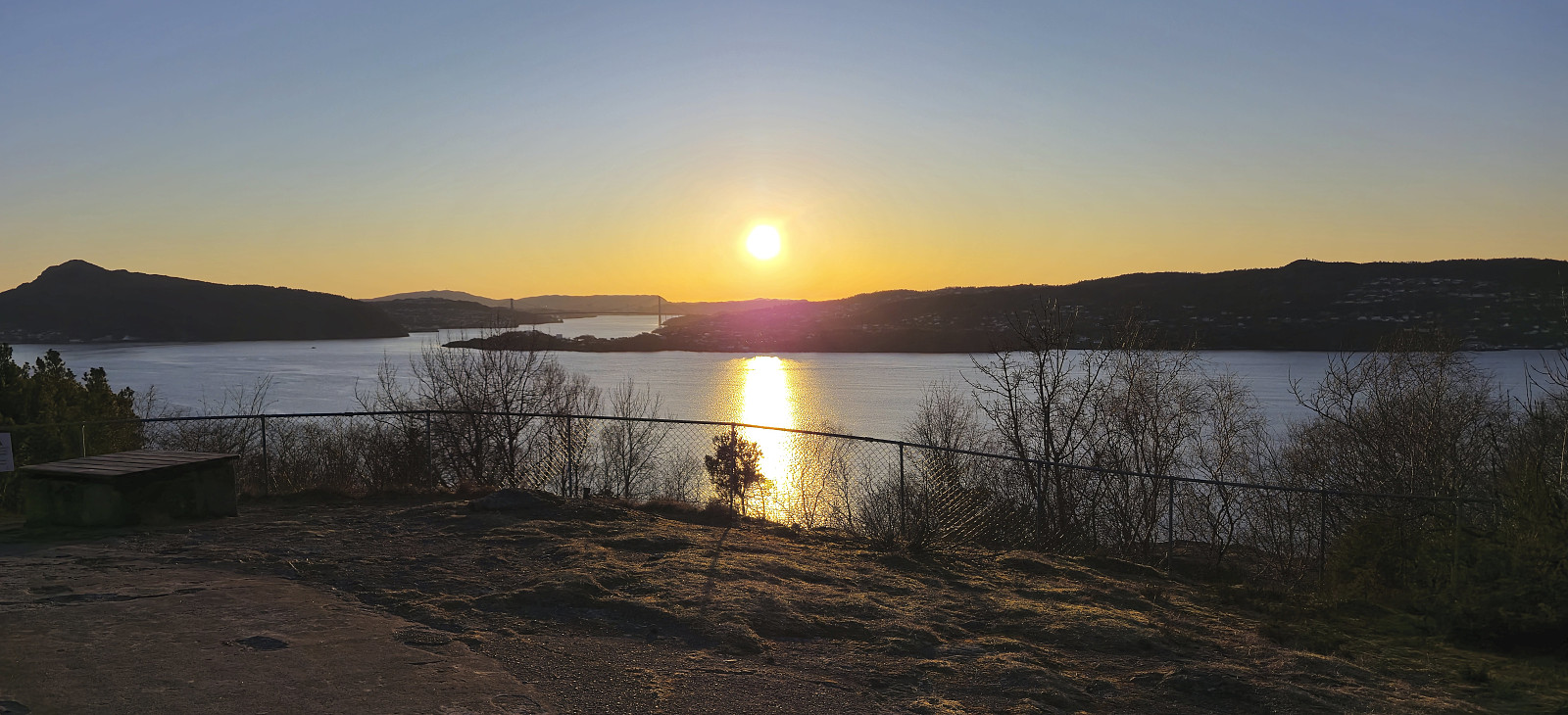 After our short skiing trip in Masfjorden , we, quite unusually for us, returned to Bergen while the sun was still shining. Endre therefore suggested that I perhaps could give him a guided tour of Hellen festning (after seeing my numerous "Across Hellen festning" trip reports here on Peakbook), and I was of course more than happy to oblige. We parked as close to Hellen festning as possible and completed the final short distance on foot. The guided tour was afterwards extended to also include a brief visit of my apartment just as the sun was setting. Takk for nok en strålende dag på tur, Endre!
Sør for Meinsperro
- Datum:
- 09.02.2025
- Tourcharakter:
- Tourenskilauf
- Tourlänge:
- 3:14h
- Entfernung:
- 7,6km
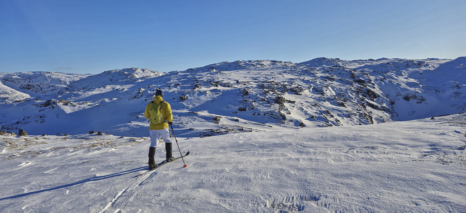 A short backcountry skiing trip with Endre where we started from the parking lot outside Stordalen Fjellstove and from there followed a marked trail towards Rusta (and Gygrebotnen). At first we had to carry the skis but at just below 700 meters we put them on and kept them on until the summit area at Sør for Meinsperro . The skiing conditions can best be described as highly variable but also with several quite nice sections.
We had initially considered continuing to Årsdalsryggen via Fjellvassbu but quickly concluded that this would take too long under the current conditions. After a couple of pictures we therefore returned more or less the same way but managed to keep the skis on for a bit longer than the point where we put them on during the ascent. Towards the end we also followed a wrong set of footprints but still easily found our way back to the parking lot.
A short backcountry skiing trip with Endre where we started from the parking lot outside Stordalen Fjellstove and from there followed a marked trail towards Rusta (and Gygrebotnen). At first we had to carry the skis but at just below 700 meters we put them on and kept them on until the summit area at Sør for Meinsperro . The skiing conditions can best be described as highly variable but also with several quite nice sections.
We had initially considered continuing to Årsdalsryggen via Fjellvassbu but quickly concluded that this would take too long under the current conditions. After a couple of pictures we therefore returned more or less the same way but managed to keep the skis on for a bit longer than the point where we put them on during the ascent. Towards the end we also followed a wrong set of footprints but still easily found our way back to the parking lot.
Hattråsen and Smørkisfjellet
- Datum:
- 08.02.2025
- Tourcharakter:
- Bergtour
- Tourlänge:
- 2:16h
- Entfernung:
- 8,7km
 A return to Kalandseidet to visit two recent additions to the Alle topper i Bergen list .
From the bus stop I followed the various roads to Hattråsdalen, only making a short detour to Styrshaugen, and then headed off-trail up the valley east of the summit of Hattråsen . Here I came across a trail marked with red and white plastic ribbons that took me almost to the summit.
But when the trail started descending south along the ridge, I instead headed off-trail to the summit which, despite a minor fight with the many juniper bushes, was reached without any real issues. The summit provided views to the south but slightly better views could be obtained from just south of the highest point.
I returned to the marked trail and proceeded to briefly follow it north in order to reconnect with the gravel road. But again the markers headed >>>
A return to Kalandseidet to visit two recent additions to the Alle topper i Bergen list .
From the bus stop I followed the various roads to Hattråsdalen, only making a short detour to Styrshaugen, and then headed off-trail up the valley east of the summit of Hattråsen . Here I came across a trail marked with red and white plastic ribbons that took me almost to the summit.
But when the trail started descending south along the ridge, I instead headed off-trail to the summit which, despite a minor fight with the many juniper bushes, was reached without any real issues. The summit provided views to the south but slightly better views could be obtained from just south of the highest point.
I returned to the marked trail and proceeded to briefly follow it north in order to reconnect with the gravel road. But again the markers headed >>>
Haukeland sykehus to Bryggen
- Datum:
- 07.02.2025
- Tourcharakter:
- Spaziergang
- Tourlänge:
- 1:23h
- Entfernung:
- 5,1km
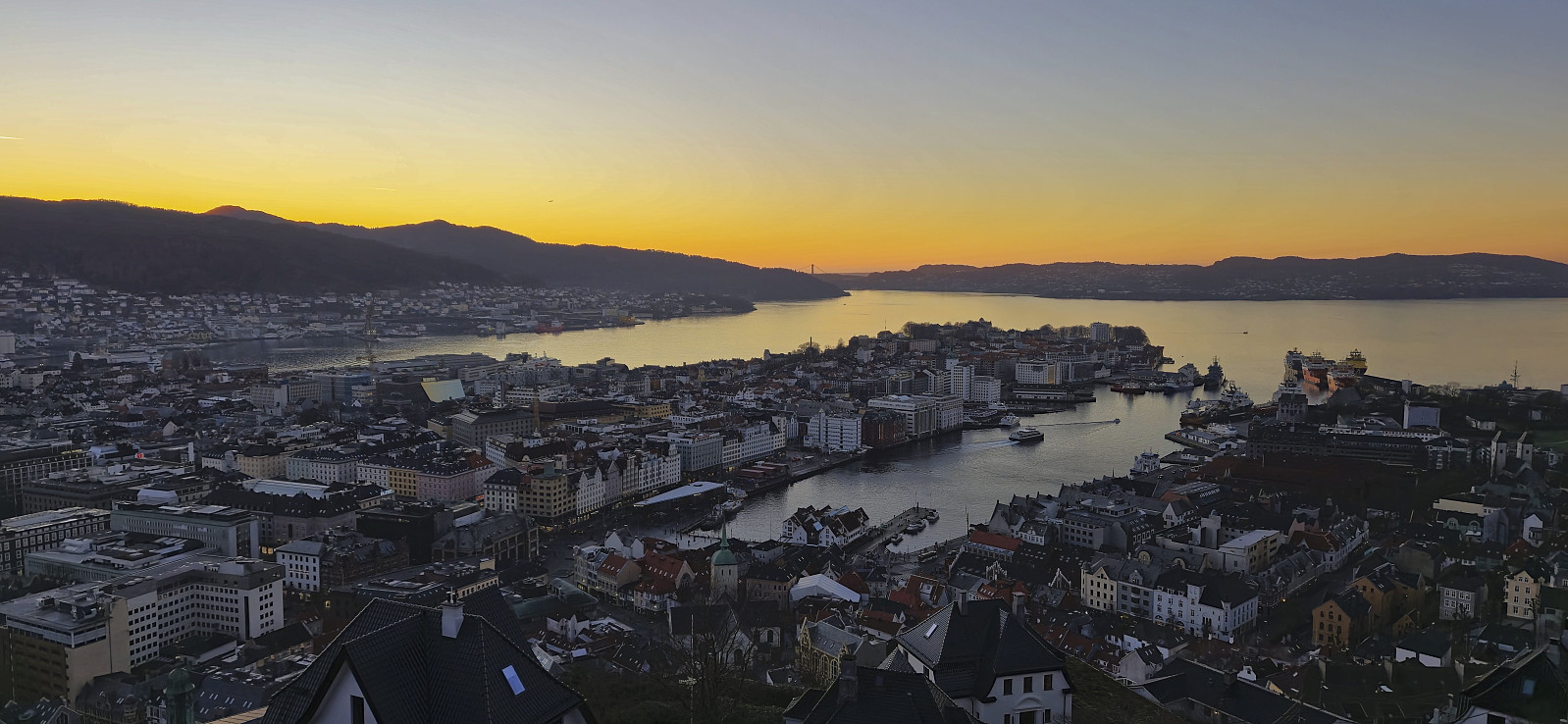 Short walk on the way home from work. Managed to convince two colleagues to join.
Ørneberget and Hellen festning
- Datum:
- 06.02.2025
- Tourcharakter:
- Bergtour
- Tourlänge:
- 0:57h
- Entfernung:
- 4,2km
 Short local hike to catch the sunset at Ørneberget .
Stendafjellet and Barkehelleren
- Datum:
- 02.02.2025
- Tourcharakter:
- Bergtour
- Tourlänge:
- 1:57h
- Entfernung:
- 7,4km
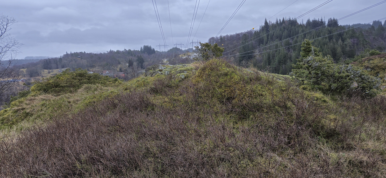 On a gray Sunday, and after a full day of hiking in Masfjorden the day before, I decided on a short hike to yet another minor peak on the Alle topper i Bergen list . I started by taking the bus to Lagunen from where I followed the roads up to Stendafjellet . Here I made a short revisit of the summit before returning to the gravel road and following it south and then north to Kandalskaret. Here I came across a trail marked with orange paint that led me almost all the way to summit of Barkehelleren , only requiring a minor detour.
The summit could have provided decent views but these were largely ruined by the numerous overhanging powerlines. I therefore did not stay long before returning to the trail and heading north for a brief visit of Nubben, just in case it at some point is also added to the Alle topper i Bergen list. Nubben was however even less interesting than Barkehelleren. >>>
On a gray Sunday, and after a full day of hiking in Masfjorden the day before, I decided on a short hike to yet another minor peak on the Alle topper i Bergen list . I started by taking the bus to Lagunen from where I followed the roads up to Stendafjellet . Here I made a short revisit of the summit before returning to the gravel road and following it south and then north to Kandalskaret. Here I came across a trail marked with orange paint that led me almost all the way to summit of Barkehelleren , only requiring a minor detour.
The summit could have provided decent views but these were largely ruined by the numerous overhanging powerlines. I therefore did not stay long before returning to the trail and heading north for a brief visit of Nubben, just in case it at some point is also added to the Alle topper i Bergen list. Nubben was however even less interesting than Barkehelleren. >>>
Klettane, again...
- Datum:
- 01.02.2025
- Tourcharakter:
- Bergtour
- Tourlänge:
- 1:08h
- Entfernung:
- 2,7km
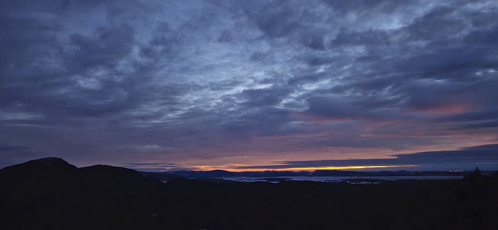 After our long hike to Storenova, Gulbrekkefjellet and Hisbotsnuken , Endre and I drove the short distance east to Kvamdalsvanet to take care of some unfinished business. It turned out that we at our previous visit of Klettane and not in fact visited the highest point, as this had since been moved from the western hill where the trig marker is located to a slightly higher hill around 150 meters to the east. As the day was darkening we therefore once more began the ascent up the tractor road to the wet area northeast of Klettane, but where we last time had proceeded off-trail to the summit, we now discovered a marked trail that greatly simplified the ascent.
Partly due to the limited light we managed to lose the marked trail before reaching the summit but found it again towards the end. It was now almost dark but we could enjoy the end of the sunset from the summit before >>>
After our long hike to Storenova, Gulbrekkefjellet and Hisbotsnuken , Endre and I drove the short distance east to Kvamdalsvanet to take care of some unfinished business. It turned out that we at our previous visit of Klettane and not in fact visited the highest point, as this had since been moved from the western hill where the trig marker is located to a slightly higher hill around 150 meters to the east. As the day was darkening we therefore once more began the ascent up the tractor road to the wet area northeast of Klettane, but where we last time had proceeded off-trail to the summit, we now discovered a marked trail that greatly simplified the ascent.
Partly due to the limited light we managed to lose the marked trail before reaching the summit but found it again towards the end. It was now almost dark but we could enjoy the end of the sunset from the summit before >>>
Storenova, Gulbrekkefjellet and Hisbotsnuken
- Datum:
- 01.02.2025
- Tourcharakter:
- Bergtour
- Tourlänge:
- 7:26h
- Entfernung:
- 18,6km
 Note: This hike includes several steep off-trail ascents and descents in rough terrain that may not be to everyone's liking. Please read the report carefully.
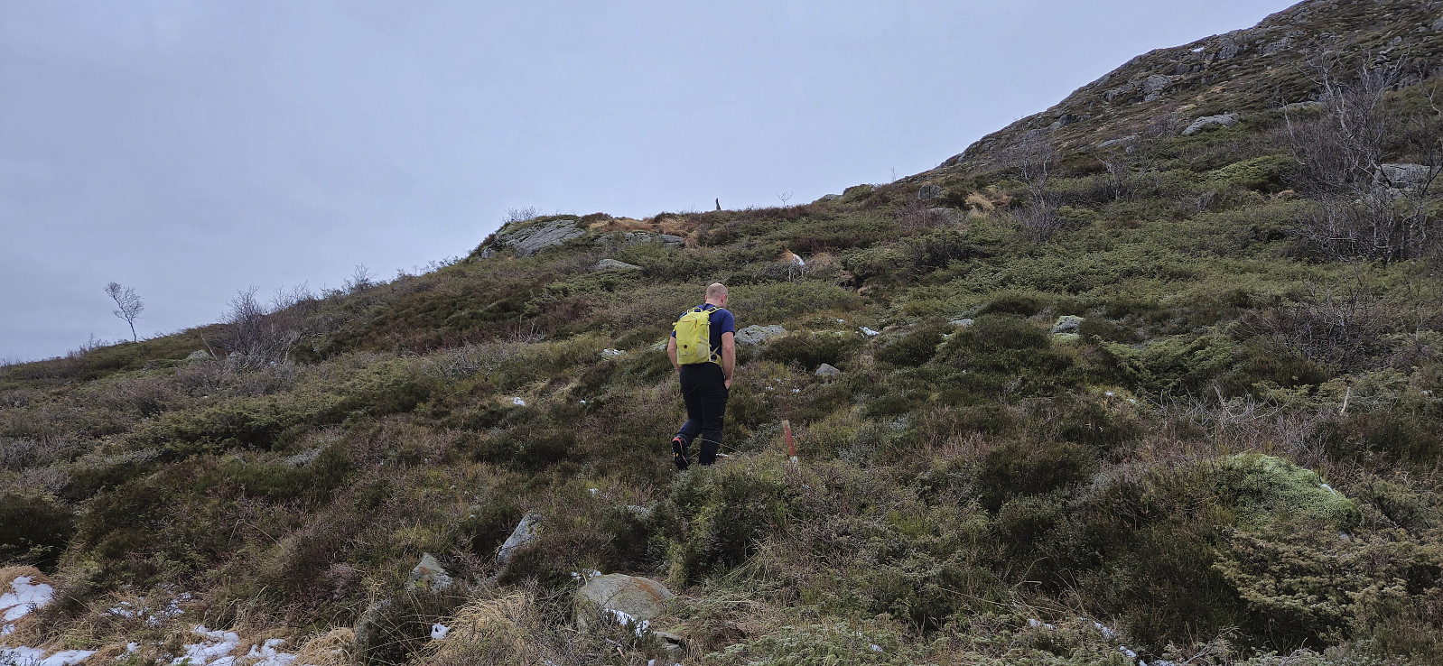
A return to Masfjorden with Endre and a plan for a roundtrip including ascents of Storanova , Gulbrekkefjellet and Hisbotsnuken . We ended up driving a bit later than planned from Bergen but thankfully still made the ferry at Masfjordnes, although with less than two minutes to spare. After the short drive from Duesund to Sleire we parked outside Sleire skulemuseum and walked the short distance west to the start of the gravel road heading northwest towards Hatleliåsen. This road later turned into a tractor road that we followed all the way to the top of the pass west of Storenova. Here we, to our surprise, found a marked trail that led us all the way to the large summit cairn.
Inspired by an external trip report by Arnt Flatmo , we >>>
Note: This hike includes several steep off-trail ascents and descents in rough terrain that may not be to everyone's liking. Please read the report carefully.
A return to Masfjorden with Endre and a plan for a roundtrip including ascents of Storanova , Gulbrekkefjellet and Hisbotsnuken . We ended up driving a bit later than planned from Bergen but thankfully still made the ferry at Masfjordnes, although with less than two minutes to spare. After the short drive from Duesund to Sleire we parked outside Sleire skulemuseum and walked the short distance west to the start of the gravel road heading northwest towards Hatleliåsen. This road later turned into a tractor road that we followed all the way to the top of the pass west of Storenova. Here we, to our surprise, found a marked trail that led us all the way to the large summit cairn.
Inspired by an external trip report by Arnt Flatmo , we >>>
