Archive - Date
Archive - Activity
-
Bike trip (111)
- Bike trip - mixed (25)
- Bike trip - road (86)
-
Drive (9)
- Car drive (9)
-
Other trip (3)
- Kayaking (3)
-
Ski trip (116)
- Backcountry skiing (69)
- Cross-country skiing (47)
- Trip by foot (1897)
Collected lists
-
Utvalgte topper og turmål i Bergen
(349/351)
 99%
99% -
Alle topper i Bergen
(393/400)
98%
-
Voss ≥ 100m pf.
(96/98)
97%
-
Opptur Hordaland
(144/159)
90%
-
Stasjoner på Bergensbanen
(33/40)
82%
-
Ulvik ≥ 100m pf.
(30/38)
78%
-
Hordaland ≥ 100m pf.
(624/863)
72%
-
Mjølfjell PF > 100m
(21/31)
67%
-
Jondal ≥ 100m pf.
(15/23)
65%
-
Dagsturhyttene i Vestland
(36/61)
59%
-
Sunnhordland PF >= 100m
(105/186)
56%
-
Hordaland: Hardanger PF>=100m
(196/359)
54%
-
DNT-hytter i Hordaland
(23/45)
51%
-
Kvinnherad ≥ 100m pf.
(40/79)
50%
-
Eidfjord ≥ 100m pf.
(13/42)
30%
-
Sogndal ≥ 100m pf.
(23/81)
28%
-
Gulen ≥ 100m pf.
(15/54)
27%
-
Vik i Sogn ≥ 100m pf.
(10/46)
21%
-
Sogn - Sør for Sognefjorden PF>=100m
(31/159)
19%
-
DNT-hytter i Sogn og Fjordane
(8/47)
17%

Roundtrip at Gullfjellet
- Date:
- 28.06.2017
- Characteristic:
- Hillwalk
- Duration:
- 7:22h
- Distance:
- 18.1km
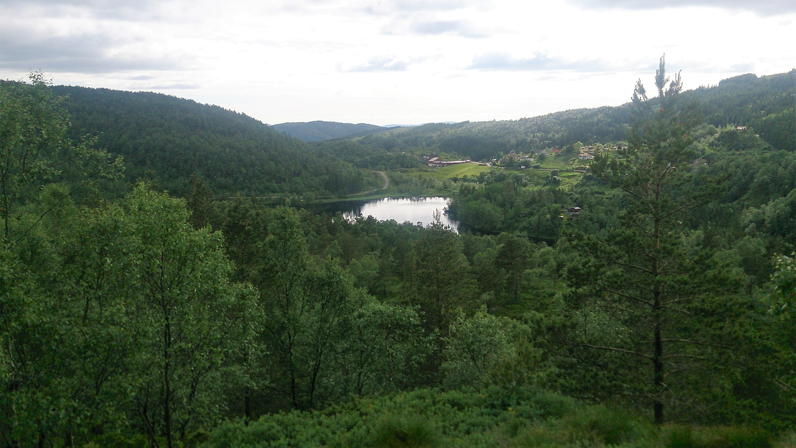
 From Osavatnet to Tjørnane
Starting from the parking lot at Osavatnet we followed the trail along the west and later north side of Svartavatnet, then up Svartavasslia to Tjørndalen, before arriving at Tjørnane. The trail was unmarked, but very nice and easy to follow.
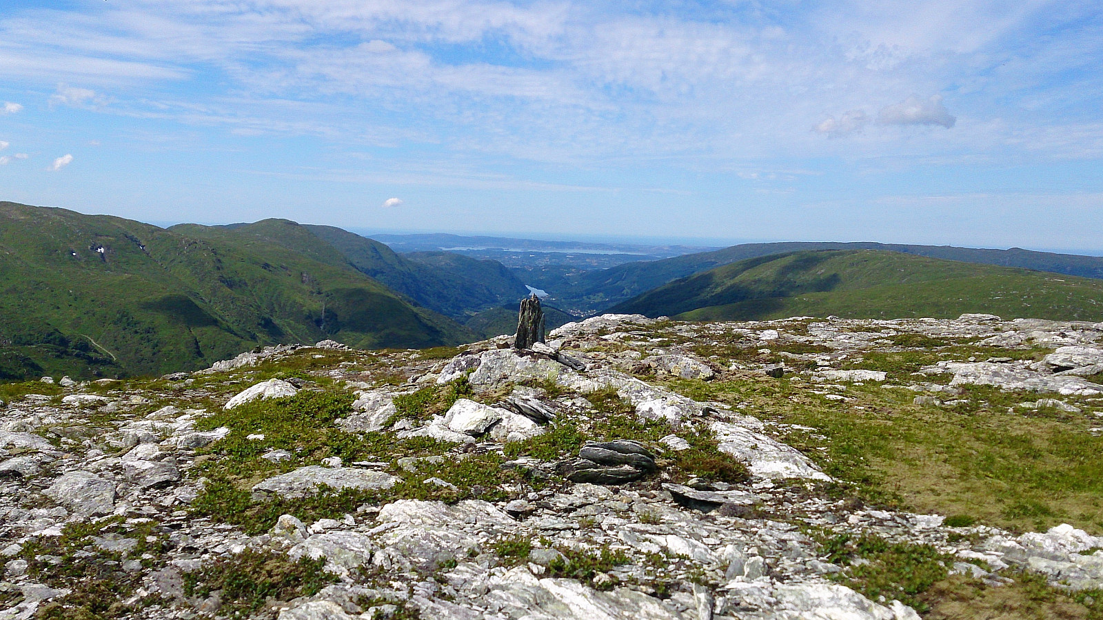
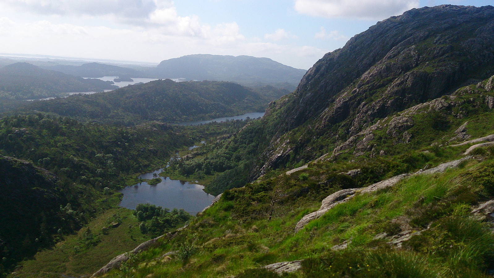
Litlagullfjellet
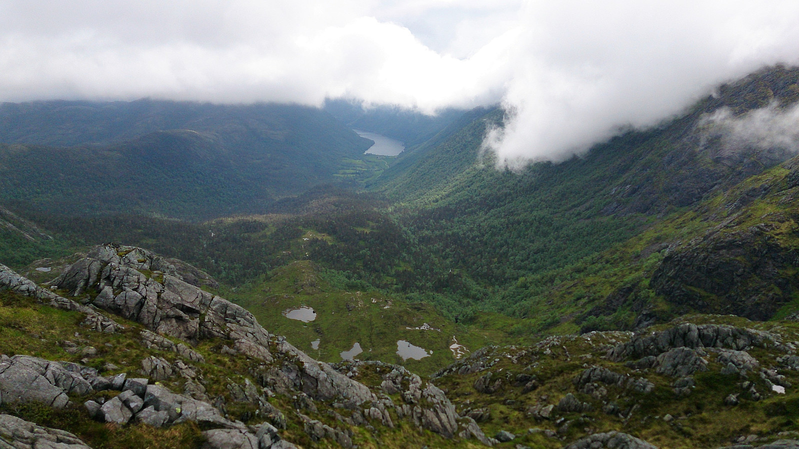
After arriving at Tjørnane, I made a quick detour to the summit of Litlagullfjellet . At first it seemed a bit difficult to ascend directly from the north. The trick was to utilize the stones sticking up out of the water on the Litlagullfjellet side of the lake (right next to where the stream from Tjørnane starts heading down to Tjørndalen). This takes you a couple of meters east, thus avoiding the steepest sections. The ascent was then much easier and only required some light climbing. The summit itself provided spectacular views in all directions >>>
From Osavatnet to Tjørnane
Starting from the parking lot at Osavatnet we followed the trail along the west and later north side of Svartavatnet, then up Svartavasslia to Tjørndalen, before arriving at Tjørnane. The trail was unmarked, but very nice and easy to follow.
Litlagullfjellet
After arriving at Tjørnane, I made a quick detour to the summit of Litlagullfjellet . At first it seemed a bit difficult to ascend directly from the north. The trick was to utilize the stones sticking up out of the water on the Litlagullfjellet side of the lake (right next to where the stream from Tjørnane starts heading down to Tjørndalen). This takes you a couple of meters east, thus avoiding the steepest sections. The ascent was then much easier and only required some light climbing. The summit itself provided spectacular views in all directions >>>
Pyttane from Straume terminal
- Date:
- 26.06.2017
- Characteristic:
- Hike
- Duration:
- 3:13h
- Distance:
- 13.7km
 A short afternoon hike that turned out a bit different than planned due to missing a connecting bus at Straume terminal. We therefore had to walk more than 4 km along the road to get to the planned start of the hike at Ekrhovda.
The summits of Pyttane provided excellent views as always, but strong winds resulted in a much shorter stay than planned. With plenty of time to spare we therefore ended up walking all the way back to Bildøybroen for the bus back to the city center. While the two walks along the road were better than expected, this part of the hike still cannot really be recommended.
A short afternoon hike that turned out a bit different than planned due to missing a connecting bus at Straume terminal. We therefore had to walk more than 4 km along the road to get to the planned start of the hike at Ekrhovda.
The summits of Pyttane provided excellent views as always, but strong winds resulted in a much shorter stay than planned. With plenty of time to spare we therefore ended up walking all the way back to Bildøybroen for the bus back to the city center. While the two walks along the road were better than expected, this part of the hike still cannot really be recommended.
Setliåsen from Søre Skulstad
- Date:
- 24.06.2017
- Characteristic:
- Hillwalk
- Duration:
- 0:33h
- Distance:
- 1.2km
 On the way back from our hike to Trengereidhotten we decided to take a quick detour to Setliåsen . From Trengereid we drove up to Søre Skulstad and parked at the final bend in the road before reaching Kråni.
(Note that there is really only room for one car here. An alternative parking location could perhaps be next to the small football field one passes around 800 meters earlier.)
The trailhead was very easy to locate and started directly from the road, and the quality was quite ok until reaching the cabin indicated on the map. Here the trail more or less disappeared, but we relocated it at just north of the ridge heading towards the summit. From there the trail was easy to follow, but very wet and muddy.
The summit provided limited views, mainly towards the roundabout at Trengereid. In summary, a very short hike to >>>
On the way back from our hike to Trengereidhotten we decided to take a quick detour to Setliåsen . From Trengereid we drove up to Søre Skulstad and parked at the final bend in the road before reaching Kråni.
(Note that there is really only room for one car here. An alternative parking location could perhaps be next to the small football field one passes around 800 meters earlier.)
The trailhead was very easy to locate and started directly from the road, and the quality was quite ok until reaching the cabin indicated on the map. Here the trail more or less disappeared, but we relocated it at just north of the ridge heading towards the summit. From there the trail was easy to follow, but very wet and muddy.
The summit provided limited views, mainly towards the roundabout at Trengereid. In summary, a very short hike to >>>
Trengereidhotten
- Date:
- 24.06.2017
- Characteristic:
- Hillwalk
- Duration:
- 3:06h
- Distance:
- 8.8km
 From the Gullbotn parking lot we followed the standard trail towards Gullfjellet , but before reaching the valley (that is also) called Gullbotn we started looking for a trail north towards Trengereidhotten . Such a trail was indicated on the map, but we failed to locate the trailhead. However, after a couple of minutes of walking a weak trail appeared.
We then followed this trail, without too much difficulty, all the way to the summit, with the exception of a section close to the summit where we lost the trail for a short time. Calling it a trail is perhaps a bit of an exaggeration though, as it was quite weak at times, and most of it was also very wet. However, the surrounding scenery was very nice and the summit itself provided excellent views in all directions!
We followed a similar route on the descent, but tried a different trail when >>>
From the Gullbotn parking lot we followed the standard trail towards Gullfjellet , but before reaching the valley (that is also) called Gullbotn we started looking for a trail north towards Trengereidhotten . Such a trail was indicated on the map, but we failed to locate the trailhead. However, after a couple of minutes of walking a weak trail appeared.
We then followed this trail, without too much difficulty, all the way to the summit, with the exception of a section close to the summit where we lost the trail for a short time. Calling it a trail is perhaps a bit of an exaggeration though, as it was quite weak at times, and most of it was also very wet. However, the surrounding scenery was very nice and the summit itself provided excellent views in all directions!
We followed a similar route on the descent, but tried a different trail when >>>
Lundåsane - from Frotveit to Totland
- Date:
- 21.06.2017
- Characteristic:
- Hillwalk
- Duration:
- 1:50h
- Distance:
- 5.9km
 Started by taking the bus to "Frotveit snuplass" and continuing north along Bontveitvegen to locate the old stone bridge required to cross the small river heading down to Frotveitvatnet. I then followed the trail east towards the cabin indicated on the map. Here the trail stopped and I had to make my own way.
Just as I made it over the first ridge, overlooking Kolhusbakkdalen, I saw a deer running north and disappearing into the woods. Sadly I did not get the time to take any pictures, but great to finally see one of the animals I had seen lots of traces of on previous hikes around Bergen.
I continued east, partially following several interconnected deer tracks, and quickly arrived at the highest point of Lundåsane , which had better views than expected. However, I was soon to realize that I >>>
Started by taking the bus to "Frotveit snuplass" and continuing north along Bontveitvegen to locate the old stone bridge required to cross the small river heading down to Frotveitvatnet. I then followed the trail east towards the cabin indicated on the map. Here the trail stopped and I had to make my own way.
Just as I made it over the first ridge, overlooking Kolhusbakkdalen, I saw a deer running north and disappearing into the woods. Sadly I did not get the time to take any pictures, but great to finally see one of the animals I had seen lots of traces of on previous hikes around Bergen.
I continued east, partially following several interconnected deer tracks, and quickly arrived at the highest point of Lundåsane , which had better views than expected. However, I was soon to realize that I >>>
Furehaugen
- Date:
- 18.06.2017
- Characteristic:
- Hillwalk
- Duration:
- 0:52h
- Distance:
- 5.2km
 Quick afternoon hike when attending a meeting at Solstrand. Started out walking, but ended up more or less running in order to make it back in time for the conference dinner. A combination of gravel/mud roads, concluded by a shortcut through very wet terrain to reach the summit, which had very limited views. The hike also included close encounters with several grazing animals, including horses and cows.
Gaustadfjellet, Borefjellet and Øyjordsfjellet
- Date:
- 16.06.2017
- Characteristic:
- Hillwalk
- Duration:
- 4:09h
- Distance:
- 10.6km
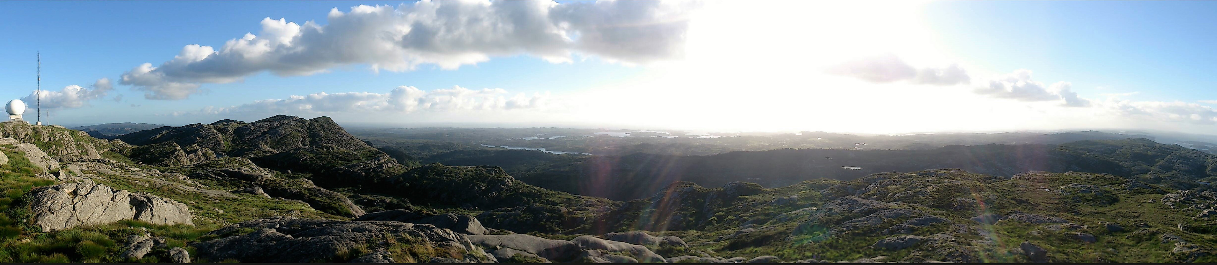
 Started from the small parking lot at Gaustad and followed a tractor road and soon trail along the ridge to the top of Gaustadfjellet . The trail was easy to follow, but did contain some rather wet areas. The summit provided excellent views in all directions!
From the summit we followed the trail north down to Ådlandsvegen, which we then followed west to Ådland where we started the ascent towards Borefjell . First along a gravel road, and then on a nice but steep trail. The trail did continue all the way to the summit, despite the map indicating otherwise. Borefjell also provided great views.
The final goal of the day was Øyjordsfjellet , and as a direct move west was not possible due to the steep cliffs, we instead followed the trail northwest. It quickly became clear that this trail was not heading towards Øyjordsfjellet though, >>>
Started from the small parking lot at Gaustad and followed a tractor road and soon trail along the ridge to the top of Gaustadfjellet . The trail was easy to follow, but did contain some rather wet areas. The summit provided excellent views in all directions!
From the summit we followed the trail north down to Ådlandsvegen, which we then followed west to Ådland where we started the ascent towards Borefjell . First along a gravel road, and then on a nice but steep trail. The trail did continue all the way to the summit, despite the map indicating otherwise. Borefjell also provided great views.
The final goal of the day was Øyjordsfjellet , and as a direct move west was not possible due to the steep cliffs, we instead followed the trail northwest. It quickly became clear that this trail was not heading towards Øyjordsfjellet though, >>>
Kolhusfjellet and Haggardsrinden
- Date:
- 14.06.2017
- Characteristic:
- Hillwalk
- Duration:
- 2:23h
- Distance:
- 5.7km
 Started by taking the bus to Øvre Totland and walking up to the nearby parking lot. The first goal of the day was Kolhusfjellet , so I followed the trail northwest to the small barn indicated on the map. There I continued north up the valley, first on a trail and soon along much weaker, most likely, deer tracks. At the first opening I turned west and headed for the summit. This initially required a bit of very light climbing, but the terrain soon turned into more of a plateau and from there it was straightforward to reach the summit.
Kolhusfjellet provided very nice views in all directions, but I did not stay long as the summit was also full of flies. So many that it actually was difficult to take any pictures without at least one of them being caught on camera! I tried moving south to the smaller hill containing the cairn , but most the flies >>>
Started by taking the bus to Øvre Totland and walking up to the nearby parking lot. The first goal of the day was Kolhusfjellet , so I followed the trail northwest to the small barn indicated on the map. There I continued north up the valley, first on a trail and soon along much weaker, most likely, deer tracks. At the first opening I turned west and headed for the summit. This initially required a bit of very light climbing, but the terrain soon turned into more of a plateau and from there it was straightforward to reach the summit.
Kolhusfjellet provided very nice views in all directions, but I did not stay long as the summit was also full of flies. So many that it actually was difficult to take any pictures without at least one of them being caught on camera! I tried moving south to the smaller hill containing the cairn , but most the flies >>>
Smøråskletten - from Valle to Lagunen
- Date:
- 12.06.2017
- Characteristic:
- Hike
- Duration:
- 1:33h
- Distance:
- 5.9km
 Short afternoon hike to cover a small summit that had been added to the "Opptur Bergen" list since my last visit to Smøråsfjellet.
Started by taking the bus to Valle and following the marked trail to Smøråsfjellet.
On my last visit the start of the trail was covered with ice. This time the ice had been replaced with water and mud, but the trail was equally poor. It quickly improved though and soon turned into a gravel road. I followed this gravel road towards Bjørnevatnet, with a very short detour to Vallastolen (and Vallastølen).
I did not find any trails to the summit of Smøråskletten , but reaching it was straightforward. Limited views from the summit, and only really worth a visit for those collecting the "Opptur Bergen" list. From the summit I continued west down to Apeltunvatnet and Lagunen >>>
Short afternoon hike to cover a small summit that had been added to the "Opptur Bergen" list since my last visit to Smøråsfjellet.
Started by taking the bus to Valle and following the marked trail to Smøråsfjellet.
On my last visit the start of the trail was covered with ice. This time the ice had been replaced with water and mud, but the trail was equally poor. It quickly improved though and soon turned into a gravel road. I followed this gravel road towards Bjørnevatnet, with a very short detour to Vallastolen (and Vallastølen).
I did not find any trails to the summit of Smøråskletten , but reaching it was straightforward. Limited views from the summit, and only really worth a visit for those collecting the "Opptur Bergen" list. From the summit I continued west down to Apeltunvatnet and Lagunen >>>
Sveningen, Søtefjellet, Sauskolten and Rindafjellet
- Date:
- 10.06.2017
- Characteristic:
- Hillwalk
- Duration:
- 8:10h
- Distance:
- 20.0km
 Started from the parking lot in Øvredalen and followed the marked trail towards Sveningen . It started raining as soon as we left the car, and in addition we were quickly surrounded by quite dense fog. But while the rain stopped an hour into the hike, the fog would follow us for almost all of the hike, dramatically reducing the expected views.
Despite the fog, the trail was easy to follow, and we soon made it to the summit of Sveningen. Here we waited a while for the fog to clear, but in the end we had to give up and continue towards the next target: Søtefjellet . We struggled a bit to locate the trail, the fog obviously not helping, but after finding the trail it was fairly easy to follow.
Shortly after leaving Sveningen, the fog cleared briefly and we got a glimpse of the views we were missing. For a moment we thought that perhaps the >>>
Started from the parking lot in Øvredalen and followed the marked trail towards Sveningen . It started raining as soon as we left the car, and in addition we were quickly surrounded by quite dense fog. But while the rain stopped an hour into the hike, the fog would follow us for almost all of the hike, dramatically reducing the expected views.
Despite the fog, the trail was easy to follow, and we soon made it to the summit of Sveningen. Here we waited a while for the fog to clear, but in the end we had to give up and continue towards the next target: Søtefjellet . We struggled a bit to locate the trail, the fog obviously not helping, but after finding the trail it was fairly easy to follow.
Shortly after leaving Sveningen, the fog cleared briefly and we got a glimpse of the views we were missing. For a moment we thought that perhaps the >>>
