Hellen festning (Peakbook vs. Norgeskart - Part 1) (04.10.2017)

| Start point | Lønborg (55m) |
|---|---|
| Endpoint | Lønborg (55m) |
| Characteristic | Hike |
| Duration | 0h 36min |
| Distance | 3.2km |
| Vertical meters | 109m |
| GPS |
|
| Ascents | Hellefjellet (135m) | 04.10.2017 18:37 |
|---|---|---|
| Visits of other PBEs | Hellen festning (131m) | 04.10.2017 18:37 |
Hellen festning (Peakbook vs. Norgeskart - Part 1)
Short hike to test the use of the Peakbook app for GPS tracking. Specifically, to compare the altitude measurements of the two apps.
For a comparison against a very similar hike using the Norgeskart app see: Hellen Festning.
Peakbook app settings:- geoid correction turned on
- tracking accuracy set to maximum
- movement recognition turned off
- update interval set to 2 seconds
- minimum distance between updates set to 2 meters
- height correction and smoothing of tracks turned on
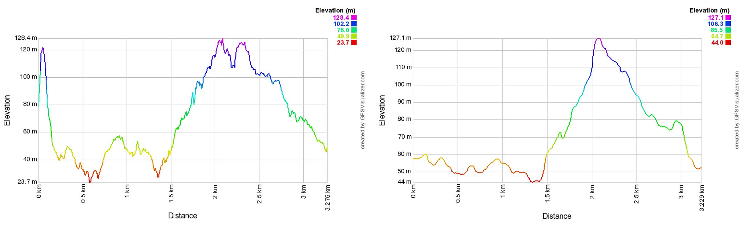
As a general observation, the results from the Peakbook app seems to be more accurate when it comes to altitude, resulting in a more correct measurement of the total number of vertical meters (261 for the Norgeskart app vs. 106 for the Peakbook app). However, the GPS tracking from the Norgeskart app has significantly more data points (1076 for the Norgeskart app vs. 338 for the Peakbook app). Perhaps increasing the update interval for the Norgeskart app will make the measurements more similar? Both apps are using the same GPS signal after all, meaning that with similar settings the results should be more or less the same?
Note also that there is a clear error in the altitude at the start of the hike tracked with the Norgeskart app (see image below), which it takes the GPS a bit of time to correct. Most likely due to not giving the GPS enough time to adjust before starting the tracking. This would reduce the total number of vertical meters for the Norgeskart app, but it would still be noticeably higher than for the Peakbook app.
Preliminary conclusion: More testing is needed. The next step will be to do the same hike and track with both apps at the same time. :)
Update (06.10.2017)
I discovered the possibility to make elevation profiles from GPX files via norgeskart.no. From what I understand this feature takes the coordinates from the GPX file and then uses the corresponding elevation from the map to calculate the altitude for each data point. This should reduce the issue of inaccurate height measurements from the GPS-app, although inaccuracies in the position will still impact the calculated height.
Here are the resulting elevation profiles after processing at norgeskart.no:
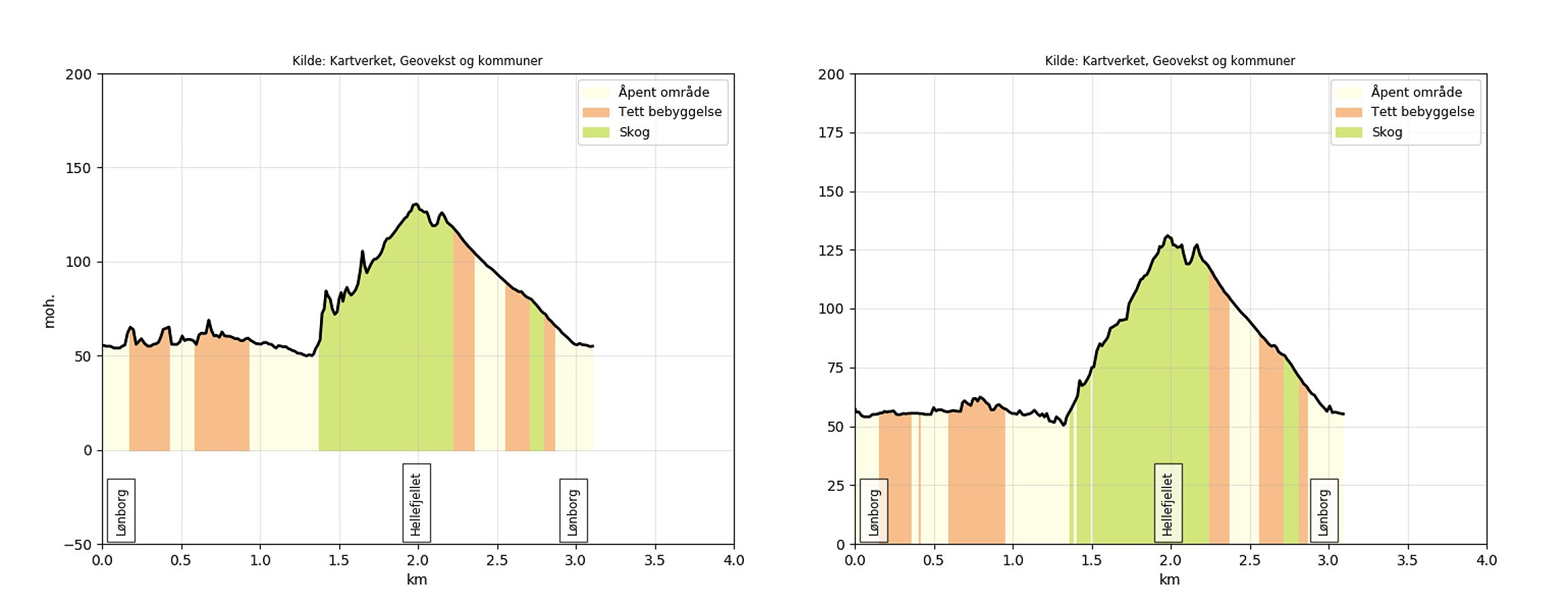
It is clear that the processing of mapping the coordinates to the underlying map makes the two profiles a lot more similar. The profile from the Norgeskart app is still more variable, which most likely can be explained by the larger number of data points which increases the chances of inaccurate coordinates.
Conclusion: Mapping the GPS coordinates to the underlying map clearly seems to improve the quality of the elevation profiles. Perhaps this feature is something PB should consider implementing as an option when importing data from GPX files?
Technical detail: Note that in order to load all the data from GPX files created by the Norgeskart app when using the elevation profile feature at norgeskart.no one has to manually edit the GPX file before loading it (which is not the case for data from the other sources I've tested). Specifically the intermediate </trkseg><trkseg> tags have to be removed, i.e. making all the <trkpt> elements belong to one <trkseg> element, as norgeskart.no seems to only load the first <trkseg> element in the file and ignores all the rest.
| Start date | 04.10.2017 18:37 (UTC+01:00 DST) |
| End date | 04.10.2017 19:10 (UTC+01:00 DST) |
| Total Time | 0h 33min |
| Moving Time | 0h 33min |
| Stopped Time | 0h 0min |
| Overall Average | 5.9km/h |
| Moving Average | 5.9km/h |
| Distance | 3.2km |
| Vertical meters | 108m |

User comments
Accuracy 2
Written by Chris 06.10.2017 02:36The truth is, GPS as we are used to use it is not bad but it's far from good. Especially phones have really bad receivers but they are convenient because we have them at hand at every time.
If one really wants accuracy with GPS we'd need advanced devices which can collect data from each satellite (not only the final result) and correction data from stationary GPS receivers.
If you aren't familiar with this already this might be a starting point if you are interested how this is working:
https://en.wikipedia.org/wiki/Differential_GPS
Accuracy
Written by Chris 06.10.2017 02:33More points don't mean necessarily more accuracy. More points simply mean more samples. This is useful when you want to describe a circle but if you describe a straight it just means more jittering and thus less accuracy. The same goes for elevation data. From my experience more samples mean less accuracy in elevantion data because GPS is really bad at elevations (phones are even worse than GPS devices) and much worse at keeping the elevation constant due to the jittering you always experience. This is where post processing comes in. What we do at peakbook is far from the best possible but it's not so bad from what I have observed in many many tracks.
There are also a lot of possibilities how to do it but in the end everything depends highly on the raw material. If you have good material the result will be more accurate if not it'll be less precise no matter which method you apply.
Re: Accuracy
Written by hbar 06.10.2017 13:10Thanks for the detailed response! I guess the question then becomes which update interval that is recommended to use in the Norgeskart app in order or make the data more comparable with the data from the PB app?
I understand that the post-processing would also be different, but at least with similar usage of the GPS the results from the two apps ought to become more similar?
Aw: Re: Accuracy
Written by Chris 07.10.2017 12:49If you track with both apps on the same phone at the same time you'll get the same raw information in both apps as they receive both their locations from the OS.
From the image you posted for the Norgeskart app it looks like there none or very limited postprocessing got applied.
Highest in PB-app means location every 7 meters and/or 5 seconds. Note that it isn't 100% guarateed to receive a location at those intervalls by the OS.
Flott sammenstilling av data
Written by knutsverre 05.10.2017 22:41Gjorde en sammenlikning av PB-appen med Garmin GPS i dag under en tur til Knappenfjellet idag. Ganske like data, men høydene på PB-appen stemmer ikke hos meg. Ser ut som om du har fått rett starthøyde fra PB-appen.
Re: Flott sammenstilling av da
Written by hbar 06.10.2017 12:59Når det gjelder starthøyde så har jeg også i Norgeskart-appen fått gale verdier. Ser for eksempel ofte negative starthøyder i sporingen (selv om GPSen har vært på i lengre tid før sporingen starter og viser rett høyde før sporing), som riktignok fort blir korrigert men medfører at jeg ofte manuelt må legge inn starthøyden i turrapporten.
Så dette viser nok mest kvaliteten på GPS-signalet fra mobilen enn en forskjell på de ulike appene som kan brukes.
Sv: Re: Flott sammenstilling a
Written by SturlaS 06.10.2017 15:07Kanskje norgeskart bruker kartreferansen til å "slå opp" i kartet sitt for å finne starthøyde? Deler av landet er jo dekt av 1m-koter og flere kommer til, så en nøyaktig GPS-referanse vil i slike tilfeller gi en relativt nøyaktig høyde. Problemet kan være at GPS-referansen ikke er så nøyaktig før du har flyttet litt på telefonen..
Høyden fra GPS-signalet er ikke veldig presis (som Chris forklarer over).
Re: Sv: Re: Flott sammenstilli
Written by hbar 06.10.2017 15:39Har også tenkt på at en løsning med å bruke kartreferansen til å finne høyden istedenfor å stole på høyden fra GPSen kunne være en mulighet, men har ikke klart å finne ut om dette er noe Norgeskart, eller andre apper, bruker. Eneste jeg fant var denne, som ikke ser ut til å støtte sporing, kun enkeltpunkter: https://data.norge.no/app/above-h%C3%B8yde-over-havet
Re: Sv: Re: Flott sammenstilli
Written by hbar 06.10.2017 16:49Oppdatering: Ser ut til at Norgeskart kun bruker kartreferansen for å finne høyden når man velger å opprette et "interessepunkt". Søk etter "Hent høyde for nye punkter" på følgende link for detaljer: http://norgeskart.wiki/nb/brukerveiledning/grunnleggende-funksjonalitet/
Denne funksjonaliteten er begrenset til 300 punkter per dag, og benyttes med andre ord derfor ikke ved sporing.
Men på norgeskart.no kan man har man funksjonen "Lag høydeprofil", som tar inn en gpx fil og gir ut en høydeprofil ved å mappe GPS-koordinatene til kartet. Har nå oppdatert turrapporten med en ny sammenligning av høydeprofilene.
Fortsatt ikke helt like (er jo tross alt to forskjellig GPS-sporinger), men mye nærmere hverandre. Profilen fra Norgeskart-appen har fortsatt mer variasjon, men skyldes nok at den har flere datapunkter og dermed større sjanse for feil i selve GPS-sporet.
Så da mangler det vel bare at PB implementerer mulighetene for en slik transformering ved opplastning
Re: Sv: Re: Flott sammenstilli
Written by hbar 30.10.2017 16:01Kom over et verktøy som kalkulerer høyde basert på GPS-koordinatene i GPX-filer: http://www.gpsvisualizer.com/elevation. Ser ut til å fungere bra. For turen min til Iseggene endres totalt antall høydemeter fra 1085 til 571, noe som virker mer korrekt: https://peakbook.org/hbar/tour/236784/Iseggene+from+Valestrand.html
Så da gjenstår det bare å gjøre tilsvarende rettelse på alle de andre turrapportene mine. :)