Arkiv - dato
Arkiv - aktivitet
-
Annen tur (1)
- Ekspedisjon (1)
-
Annen vintertur (9)
- Trugetur (9)
- Fottur (222)
-
Klatring (8)
- Alpin klatring (7)
- Miksklatring (1)
-
Skitur (48)
- Randonnée/Telemark (48)
-
Sykkeltur (2)
- Terrengsykling (1)

Til Skolmelia og Såta på truger
- Dato:
- 17.01.2026
- Turtype:
- Trugetur
- Turlengde:
- 6:01t
- Distanse:
- 10,3km
Fjelltur til Frænavarden med Sol
- Dato:
- 18.10.2025
- Turtype:
- Fjelltur
- Turlengde:
- 4:32t
- Distanse:
- 13,7km
Tur til Moldurfjellet i Ytre Sogn
- Dato:
- 14.10.2025
- Turtype:
- Fjelltur
- Turlengde:
- 3:22t
- Distanse:
- 9,6km
Fjelltur til Eggenibba med Dag
- Dato:
- 12.10.2025
- Turtype:
- Fjelltur
- Turlengde:
- 3:05t
- Distanse:
- 5,0km
Til Liafjellet med Sol
- Dato:
- 04.10.2025
- Turtype:
- Fjelltur
- Turlengde:
- 2:57t
- Distanse:
- 9,0km
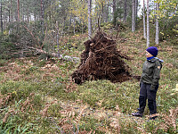 Denne dagen var det jeg og eldste datter som dro på tur sammen. Jeg hadde ikke vært på Liafjellet før, men eldste-sønnen, Dag, hadde fortalt at det var en fin og ikke så lang tur, og han hadde også nevnt at det gikk an å parkere på gamle-veien nedenfor Tøssesvingen, og stort sett følge Liafjellets vestrygg opp til topps. Det nevnte stedet der man kan parkere, er ikke synlig fra riksveien. Da riksveien ble utbedret tidlig på 2000-tallet, ble det anlagt en helt ny sving ca. 30 meter innenfor, og 8 høydemeter ovenfor den gamle Tøssesvingen, slik at veien ikke bare ble utbedret, men svingen også rettet ut en del. Den gamle veien ble imidlertid ikke fjernet, og hvis man tar til høyre like etter svingen (når man kommer kjørende i retning Sjøholt), så er det ikke så vanskelig >>>
Fottur til Englafjellet, Ulvanosa og Geitadalstinden
- Dato:
- 20.09.2025
- Turtype:
- Fjelltur
- Turlengde:
- 8:53t
- Distanse:
- 21,8km
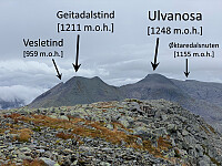 Jeg var på besøk hos venner i Uskedalen da jeg la ut på denne turen. Været var skyet, og ikke på noen måte det beste, men jeg var blitt lokket til disse traktene med at det skulle være så fine fjell her omkring, og da var det liksom ikke så aktuelt å ikke få seg en fjelltur i løpet av helgen. Vennene jeg besøkte bor omtrent akkurat der Eikedalselva kommer ned, og dermed var enkleste veien til fjells rett og slett å ta veien oppover Eikedalen. Dagens turmål var Englafjell [1200 m.o.h.]. Man kan også bestige dette fjellet ved å følge fjellryggen opp fra Uskedalen, men da måtte jeg enten starte i selve Uskedalen, ved gardsbruket Fet, eller så måtte jeg et eller annet sted krysse Eikedalselva, for å komme meg bort til ryggen.
Jeg fulgte grusveien oppover Eikedalselva så langt >>>
Til Myrsethornet og Manfjellet på Otrøya
- Dato:
- 23.08.2025
- Turlengde:
- 6:00t
- Distanse:
- 16,0km
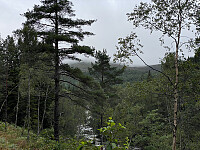 I forbindelse med at jeg forsøker å fylle opp lista over Romsdalstopper med primærfaktor > 100 meter, har jeg besteget toppene på Otrøya i tur og orden; og jeg manglet nå bare to av dem, nemlig Manfjellet [668 m.o.h.] og Myrsethornet [670 m.o.h.]. Jeg studerte forut for denne turen kartet ganske nøye, og så for meg to mulige ruter for å bestige disse to toppene. Alternativ nr. 1 var å starte turen på Beinset og følge fjellryggen derfra opp på Manfjellet, for så å ta seg over til Myrsethornet, og deretter følge en ny fjellrygg ned til Sundsbø. Det andre alternativet var å følge Nord-Heggdalen inn mot Heggdalsvatnet [255 m.o.h.], for derfra å gå opp på Myrsethornet, så videre bort på Manfjellet, for så å ta seg tilbake til Nord-Heggdalen. Det ble til at jeg valgte >>>
En kjapp klatretur opp på Gran Canarias høyeste punkt
- Dato:
- 16.08.2025
- Turlengde:
- 0:43t
- Distanse:
- 0,9km
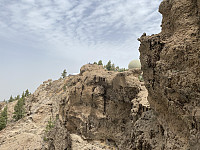 I motsetning til mange andre nordmenn, hadde min kone og jeg aldri vært på Gran Canaria, før vi tok denne turen. Det var ikke noen typisk pakketur, vi bestilte flyreiser, opphold, og leiebil helt separat. Det blir naturligvis litt mer kostbart når man gjør det på denne måten, men det ga oss friheten til å velge resort etter eget ønske, og leiebilen gjorde det mulig for oss å komme oss rundt på øya så mye vi bare ville.
Første målet denne dagen var Pico de las Nieves [1950 m.o.h.] og Morrón de la agujereada [1961 m.o.h.], begge omtrent midt på øya. Vi kjørte nordøstover fra Maspalomas langs motorvei GC-1 omtrent til der flyplassen Aeropuerto de Gran Canaria ligger, og tok så vestover langs GC-120. Denne veien følger man opp til landsbyen Cazadores, og derfra følger man >>>
På Romsdalshornet for tolvte gang
- Dato:
- 04.08.2025
- Turtype:
- Alpin klatring
- Turlengde:
- 3:42t
- Distanse:
- 4,7km
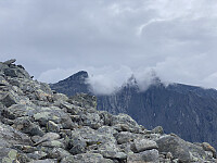 Romsdalshornet er med tiden blitt mitt favorittfjell nr. 1. Jeg var oppom der en tur i begynnelsen av juni, men hadde lyst på i hvert fall én tur til denne sesongen, og slik fikk jeg hug til å prøve meg på dette fjellet også denne sommerdagen. Det var riktig nok ikke sol fra skyfri himmel, men det fikk våge seg; tåka (bilde ##1-2) lå ikke tettere enn at jeg forventet at fjellet stort sett var tørt oppover.
Jeg parkerte øverst i Venjedalen, og la i vei, forbi Hornvatnet [760 m.o.h.], og derfra oppover fjellsida til jeg var oppe på eggen mellom Litlefjellet og Hornet. Herfra fulgte jeg stien oppover mot det såkalte Gapet, et lite skar som ligger akkurat der klatrepartiet på Nordryggen begynner. Herfra er det bratt og eksponert like opp til toppen. Kjenner man denne fjellveggen godt, >>>

