Archive - Date
Archive - Activity
- Bike trip (2)
-
Climbing (8)
- Alpine climbing (7)
- Mixed climbing (1)
-
Other trip (1)
- Expedition (1)
-
Other winter trip (10)
- Snowshoe trip (10)
-
Ski trip (49)
- Randonnée/Telemark (49)
-
Trip by foot (228)
- Alpine trip (57)
- Hike (69)
- Hillwalk (89)
- Jogging (11)


Collected lists
-
Romsdal ≥ 100m pf.
(134/301)
 44%
44% -
Sunnmøre ≥ 100m pf.
(78/531)
14%
-
Norges 1000 største fjell målt i primærfaktor
(52/1000)
5%

Evening Hike Up the Northwest Ridge of Mount Ulriken
- Date:
- 20.06.2016
- Characteristic:
- Hike
- Duration:
- 2:44h
- Distance:
- 9.8km
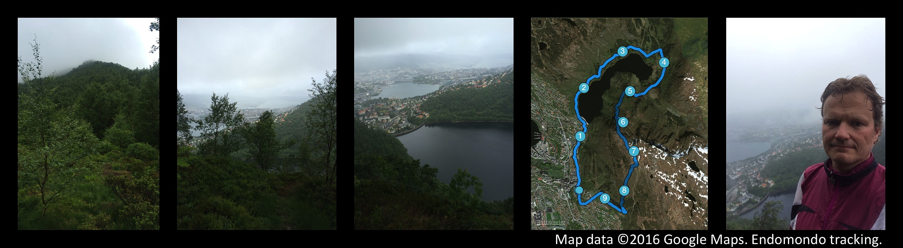 On this longest day of the year, I made this combined run and hike in the city of Bergen, Norway. I started out by running along Lake Alrekstadvatnet [commonly referred to as Svartediket, i.e. "The Black Dike"] in Ulriksdalen Valley. At the end of the valley I circumscribed the east end of the lake, passing the valleys of Våkendalen, Hardbakkedalen and Isdalen; and then came to the foot of the mountain ridge called Ulrikseggen. [The proper translation of "Ulrikseggen" is "The Mount Ulriken mountain ridge", though the Norwegian word "egg" in Ulrikseggen actually corresponds to the English word "edge"]. At the foot of The Mount Ulrik Ridge, there's some dense birch forrest, and there where multiple trails in the forrest, hence a little bit difficult >>>
Hiking to Mount Trolltind from Tomresetra with my Son Dag
- Date:
- 18.06.2016
- Characteristic:
- Hike
- Duration:
- 4:34h
- Distance:
- 10.4km
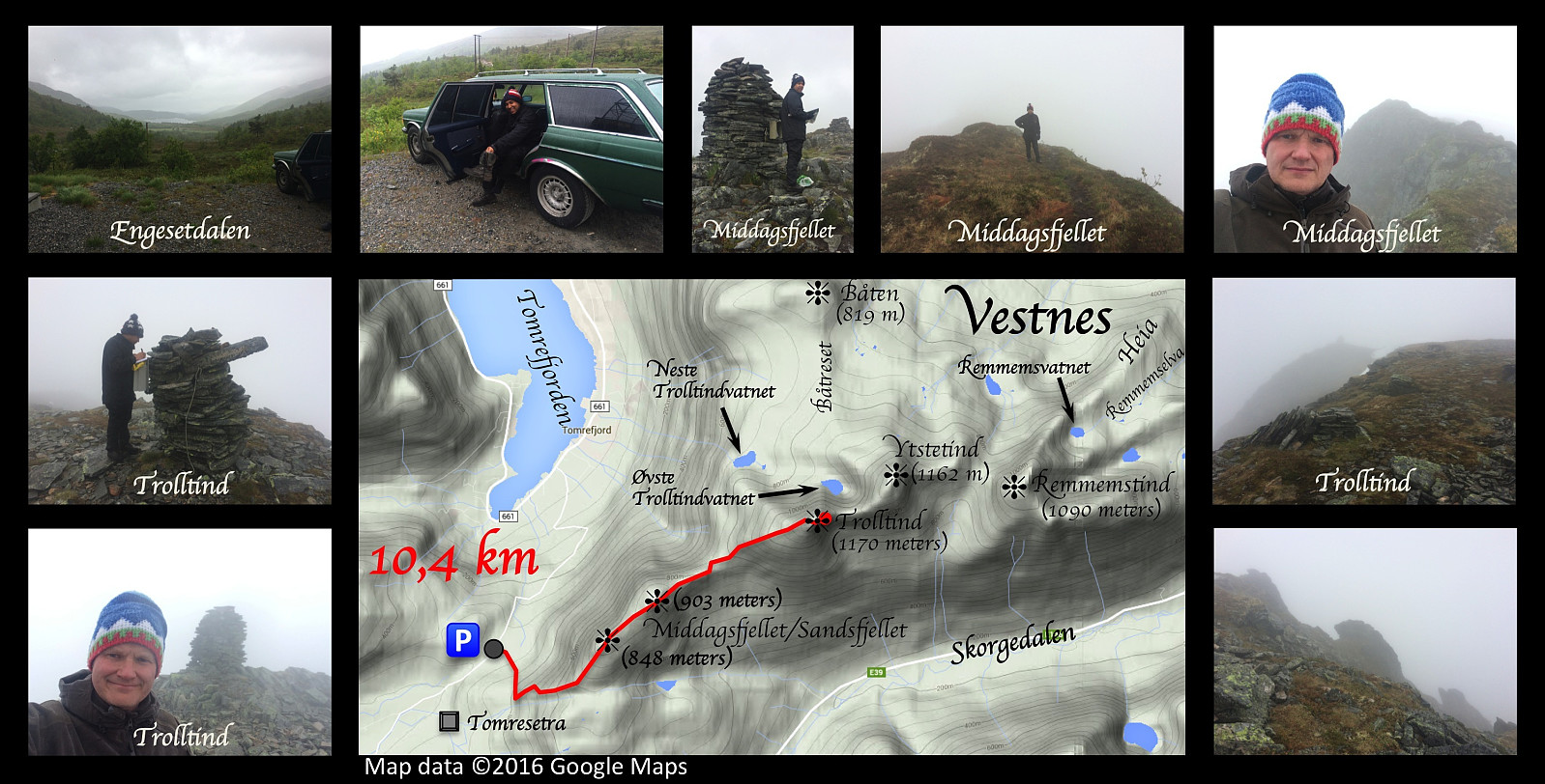 Mountain hiking to Brustind (1170 m.a.m.s.l.) with my son Dag on this day. We chose a different outset from what I did when I climbed this mountain on November 1st last year, allowing us to climb even the mountain Middagsfjellet on our way up. The literal meaning of the name "Middagsfjellet" is the "Mid-Day Mountain" or the "Noon Mountain", a name probably applied to the mountain because of its location just south of the village Tomra by the fjord Tomrefjord. At 12 o'clock the sun would be standing just above this particular mountain (for an observer in Tomrefjord); hence the inhabitants in Tomra used the mountain to mark out the time for noon back in the old days when common people didn't go around wearing watches.
This hike isn't too steep. The first part goes >>>
Mountain hiking to Brustind (1170 m.a.m.s.l.) with my son Dag on this day. We chose a different outset from what I did when I climbed this mountain on November 1st last year, allowing us to climb even the mountain Middagsfjellet on our way up. The literal meaning of the name "Middagsfjellet" is the "Mid-Day Mountain" or the "Noon Mountain", a name probably applied to the mountain because of its location just south of the village Tomra by the fjord Tomrefjord. At 12 o'clock the sun would be standing just above this particular mountain (for an observer in Tomrefjord); hence the inhabitants in Tomra used the mountain to mark out the time for noon back in the old days when common people didn't go around wearing watches.
This hike isn't too steep. The first part goes >>>
Combined run and hike the "rear way" up to Mount Ulriken
- Date:
- 16.06.2016
- Characteristic:
- Hike
- Duration:
- 2:24h
- Distance:
- 12.0km
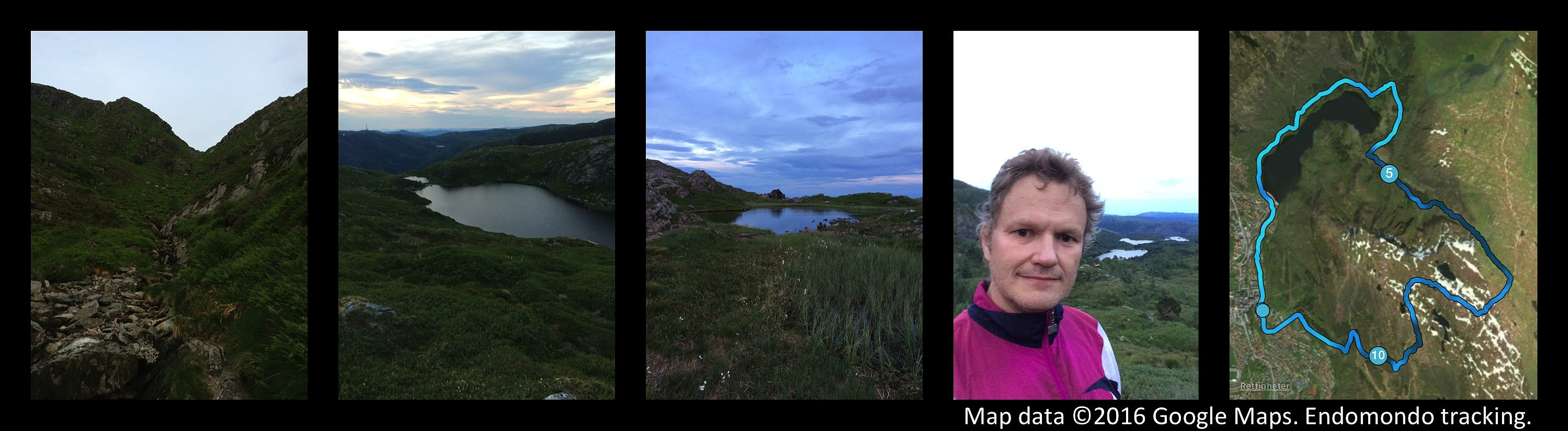 On this day I had a combined workout, i.e. I run along the road called Tarlebøveien in the Ulriksdalen Valley , and then hiked up a valley called Isdalen. Where the valley called Ulriksdalen ends, it actually divides into three separate valleys, that are called (from west to east) Våkendalen, Hardbakkedalen, and Isdalen ["dal" is the Norwegian word for "valley"]. In its upper part, Isdalen Valley is called Smalisdalen , as it narrows in a bit up there. So, I hiked up Isdalen and Smalisdalen up to the mountain plateau of which Mount Ulriken is a part. From the entrance to the plateau I ran alongside the southeast side of Mount Ulriken, and then followed a commonly used trail back down to the districts of Montana and Lægdene, where I'm renting an apartment in Bergen. (Back >>>
Til Ytsetind fra Flate
- Date:
- 11.06.2016
- Characteristic:
- Hillwalk
- Duration:
- 3:55h
- Distance:
- 12.5km
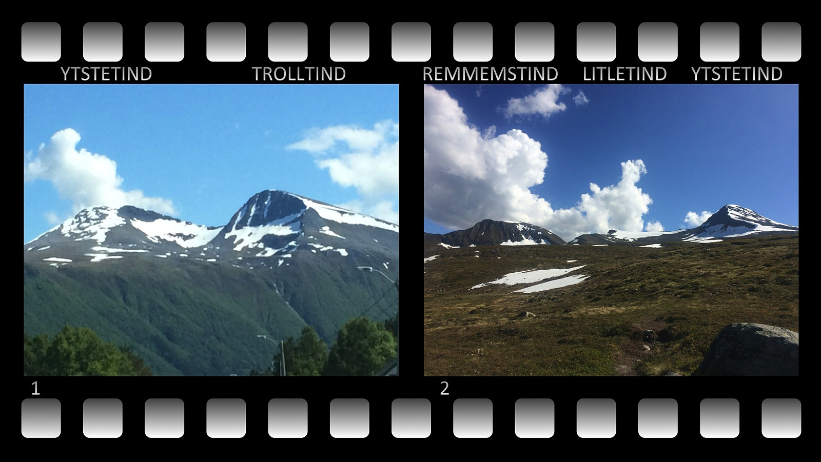 I 2015 besøkte jeg både Remmemstinden og Trolltinden i Vestnes kommune, men Ytstetinden hadde jeg enda ikke vært på, og dit hadde jeg lyst å gå. Denne lørdagen dro vi derfor avsted, jeg og eldste sønnen vår. Vi kjørte via Fiksdal og Tomrefjorden til Flatebygda, og fant fram til en parkeringsplass vi også tidligere hadde benyttet. Det var 20,- kroner å betale i bompenger for å komme opp til parkeringsplassen, og derfra la vi i vei oppover grusveien til Flateseter. Oppe ved Flatesetra er stien videre til Remmemstinden og Ytstetinden godt skiltet; dårligere med skilting er det når man kommer ut av skogen og opp på snaufjellet.
Ytstetind er forbundet med fjellet Båten med en rygg som kalles Båtreset . Vi siktet oss inn på foten av Ytstetind akkurat der fjellet går over i Båtreset. >>>
I 2015 besøkte jeg både Remmemstinden og Trolltinden i Vestnes kommune, men Ytstetinden hadde jeg enda ikke vært på, og dit hadde jeg lyst å gå. Denne lørdagen dro vi derfor avsted, jeg og eldste sønnen vår. Vi kjørte via Fiksdal og Tomrefjorden til Flatebygda, og fant fram til en parkeringsplass vi også tidligere hadde benyttet. Det var 20,- kroner å betale i bompenger for å komme opp til parkeringsplassen, og derfra la vi i vei oppover grusveien til Flateseter. Oppe ved Flatesetra er stien videre til Remmemstinden og Ytstetinden godt skiltet; dårligere med skilting er det når man kommer ut av skogen og opp på snaufjellet.
Ytstetind er forbundet med fjellet Båten med en rygg som kalles Båtreset . Vi siktet oss inn på foten av Ytstetind akkurat der fjellet går over i Båtreset. >>>
