Archivo - fecha
Archivo - actividad
- Ciclismo (2)
-
Escalada (8)
- Escalada alpino (7)
- Escalada mixta (1)
-
Excurción de esquí (49)
- Randonnée/Telemark (49)
-
Excurción de otro tipo (1)
- Expedicion (1)
- Excursión de invierno, otro tipo (10)
-
Senderismo (232)
- Excurción alpino (60)
- Running (11)
- Senderismo (69)
- Senderismo de montaña (90)


Listas obtenidas
-
Romsdal ≥ 100m pf.
(135/301)
 44%
44% -
Sunnmøre ≥ 100m pf.
(79/531)
14%
-
Norges 1000 største fjell målt i primærfaktor
(53/1000)
5%

Til Båten og Liahornet i vintervær
- Fecha:
- 14.11.2015
- Duración:
- 3:32h
- Distancia:
- 11.1km
 Denne dagen hadde vi egentlig tenkt oss opp på enten Trolltinden (1070 m.o.h.), men på grunn av været ble turen kortere og veldig annerledes fra det vi hadde tenkt. Vi parkerte på Flate, og fulgte seterveien opp til Flateseter slik vi også hadde gjort ved noen tidligere turer. Da vi var kommet ovenfor Flatesetra og klar av skogen, begynte det å snø ganske heftig, og etterhvert innså vi at det antagelig ikke var så trygt å begi seg opp hverken på Trolltind eller Ytstetind denne dagen. Men Båten måtte kunne la seg gjøre...
Med tanke på Trolltinden hadde vi siktet oss inn på Båtreset (se GPS-tracking) oppe ved foten av Ytstetind, og planen var å gå videre fra Båtreset ned til Nedste Trollvatnet, og så derfra opp på Trolltind. Etterhvert som vi klatret oppover mot Båtreset, >>>
Denne dagen hadde vi egentlig tenkt oss opp på enten Trolltinden (1070 m.o.h.), men på grunn av været ble turen kortere og veldig annerledes fra det vi hadde tenkt. Vi parkerte på Flate, og fulgte seterveien opp til Flateseter slik vi også hadde gjort ved noen tidligere turer. Da vi var kommet ovenfor Flatesetra og klar av skogen, begynte det å snø ganske heftig, og etterhvert innså vi at det antagelig ikke var så trygt å begi seg opp hverken på Trolltind eller Ytstetind denne dagen. Men Båten måtte kunne la seg gjøre...
Med tanke på Trolltinden hadde vi siktet oss inn på Båtreset (se GPS-tracking) oppe ved foten av Ytstetind, og planen var å gå videre fra Båtreset ned til Nedste Trollvatnet, og så derfra opp på Trolltind. Etterhvert som vi klatret oppover mot Båtreset, >>>
Across Mount Ulriken, Mount Rundemanen and Mount Blåmanen
- Fecha:
- 08.11.2015
- Tipo de excursión:
- Senderismo
- Duración:
- 6:43h
- Distancia:
- 23.1km
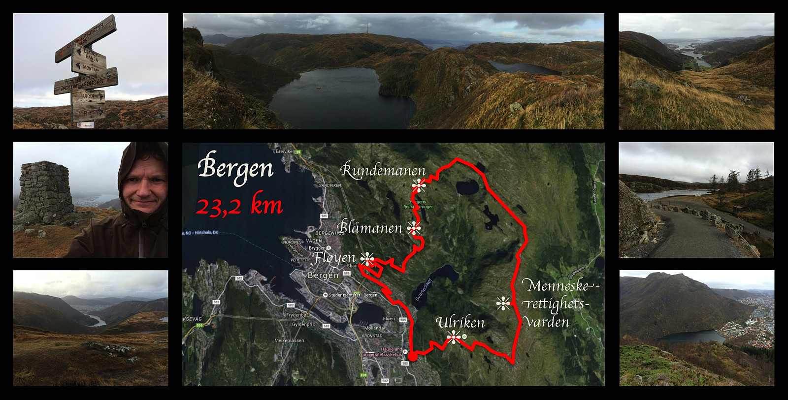 I've been working in the city of Bergen since September 2013, but I have not yet moved to Bergen. I usually go home (by plane) for the weekends unless I'm on call at the hospital where I'm working. During this particular week, however, my wife had come to Bergen to visit me instead, and we were therefore both in Bergen throughout the weekend. On Sunday I went for this 23 km long workout, where I climbed Mount Ulriken, and then followed a trail around the huge plateau that Ulriken is a part of, circumventing the valleys Isdalen, Hardbakkedalen and Våkendalen [The Norwegian word "dal" means valley]. The trail follows a mountain ridge that people in Bergen call Vidden . Finally, the trail takes you down into the pass that connects the valley of Våkendalen with the valley of Jordalen
Another Hike to Mount Ulriken
- Fecha:
- 07.11.2015
- Tipo de excursión:
- Senderismo
- Duración:
- 1:55h
- Distancia:
- 4.5km
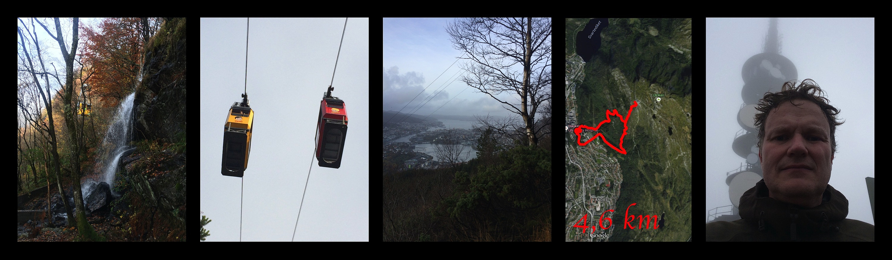 I've been working in the city of Bergen since 2013. I usually go home for the weekends, unless I'm on call. On this particular weekend I remained in Bergen, however, and so I decided to climb Mount Ulriken again to get some recreation after a busy week at work. There is a rather steep path through the forest beneath the cable car, which I followed up the mountain side. From about 400 m.a.m.s.l. there's suddenly no more forest, but the path continues up the mountain side, and then follows a little mountain ridge till you're almost on top of the mountain. The last 50 elevation meters before you reach the end station of the cable car is again a bit steep, but not in a manner that will cause any trouble for you if you're just a little bit experienced with mountain trekking. For the descent I followed >>>
