Archive - Date
Archive - Activity
- Bike trip (2)
-
Climbing (8)
- Alpine climbing (7)
- Mixed climbing (1)
-
Other trip (1)
- Expedition (1)
-
Other winter trip (10)
- Snowshoe trip (10)
-
Ski trip (49)
- Randonnée/Telemark (49)
-
Trip by foot (228)
- Alpine trip (57)
- Hike (69)
- Hillwalk (89)
- Jogging (11)


Collected lists
-
Romsdal ≥ 100m pf.
(134/301)
 44%
44% -
Sunnmøre ≥ 100m pf.
(78/531)
14%
-
Norges 1000 største fjell målt i primærfaktor
(52/1000)
5%

Another Hike to the "Big Horn" on Godøy Island
- Date:
- 26.09.2015
- Characteristic:
- Hike
- Duration:
- 3:48h
- Distance:
- 9.7km
 On this day I had another hike on the mountains of the island Godøy in Giske Municipality in Møre & Romsdal County in western Norway with my son Dag. We had a really nice hike; the pictures above speaks for themselves. The hike is pretty much identical to the one I made on May 2nd 2015. For a short tour description, see my short summary on that date, and for a map, open the GPS tracking! We parked at Hestevika Parking Lot, from where we followed the mountain path up to Lake Alnesvatnet, which is located 250 m.a.m.s.l. We next followed the mountain edge westwards to a ridge that extends northwards from Mount Storhornet, and then we just continued along this ridge up to the summit. Net, we descended the rather steep path on the west side of Storhornet, and climbed up Mount Lesten, thus >>>
Encircling the Southern Part of Mt. Sulafjellet.
- Date:
- 12.09.2015
- Characteristic:
- Hike
- Duration:
- 4:15h
- Distance:
- 13.1km
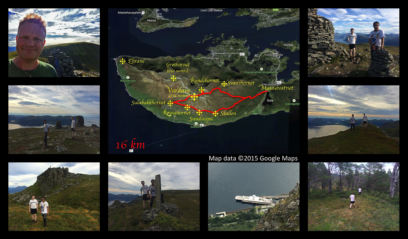 On this day I had another nice hiking trip on Mount Sulafjellet with my oldest son and one of his friends. This time we took a different route from what we've done on previous occasions; one that offers an awesome view in a southward direction. We set out from the parking lot at Mauseidvatnet as we've done before, and followed the gravel road through the forest past the cabin called Taustuhytta and up to the one called Rollonhytta . From there we continued along the mountain path that we had used before, up to the summit of the island, which is called Tverrfjellet or Vardane ; making sure though, to take a few minutes even to mount the peak called Rundehornet, so that I could tell people that I had been there also.
From Vardane we descended in southwest direction towards Sulabakkhornet, and then >>>
On this day I had another nice hiking trip on Mount Sulafjellet with my oldest son and one of his friends. This time we took a different route from what we've done on previous occasions; one that offers an awesome view in a southward direction. We set out from the parking lot at Mauseidvatnet as we've done before, and followed the gravel road through the forest past the cabin called Taustuhytta and up to the one called Rollonhytta . From there we continued along the mountain path that we had used before, up to the summit of the island, which is called Tverrfjellet or Vardane ; making sure though, to take a few minutes even to mount the peak called Rundehornet, so that I could tell people that I had been there also.
From Vardane we descended in southwest direction towards Sulabakkhornet, and then >>>
