Archive - Date
Archive - Activity
- Bike trip (2)
-
Climbing (8)
- Alpine climbing (7)
- Mixed climbing (1)
-
Other trip (1)
- Expedition (1)
-
Other winter trip (10)
- Snowshoe trip (10)
-
Ski trip (49)
- Randonnée/Telemark (49)
-
Trip by foot (234)
- Alpine trip (62)
- Hike (69)
- Hillwalk (90)
- Jogging (11)


Collected lists
-
Romsdal ≥ 100m pf.
(135/301)
 44%
44% -
Sunnmøre ≥ 100m pf.
(79/531)
14%
-
Norges 1000 største fjell målt i primærfaktor
(55/1000)
5%

To Eltrane, Far West on the Plateau of Mt. Sulafjellet
- Date:
- 29.08.2015
- Characteristic:
- Hike
- Duration:
- 7:20h
- Distance:
- 24.9km
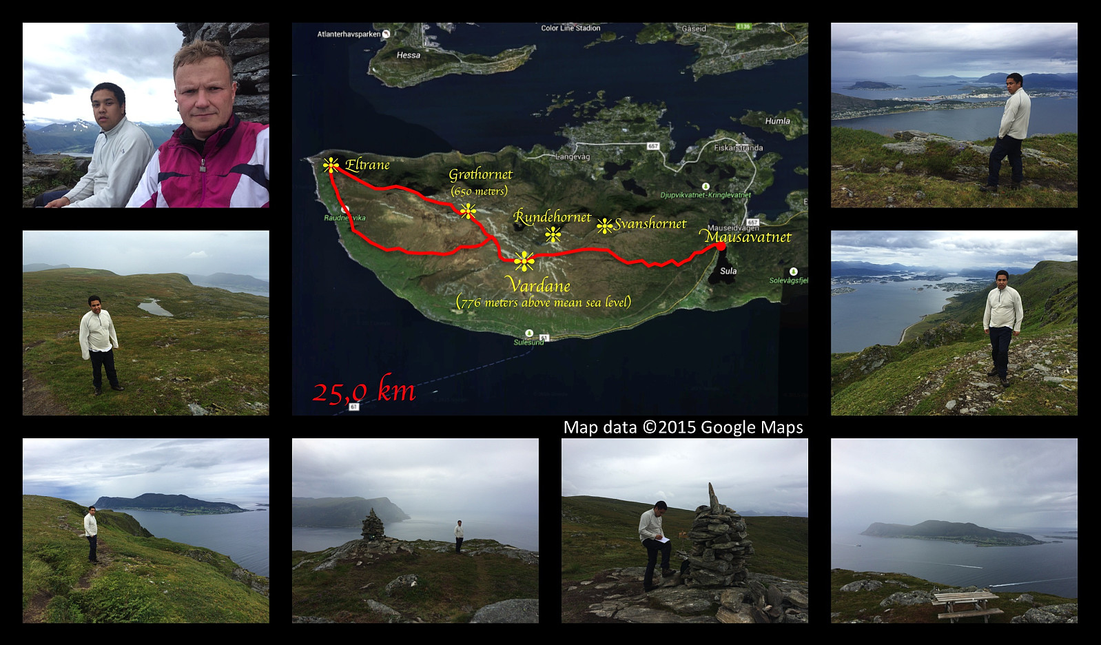 This weekend we had a really long hiking trip on Sulafjellet mountain. We started out from lake Mauseidvatnet, and went up to the highest point of the mountain as we've done on several previous occations; and from there we went on to the westmost part of Sula island, to a part of the mountain that is called Eltrane. To get there, we just followed a path along the nordthern edge of the mountain plateau that comprises most of the western part of the island. The path was nice, easy to spot, and not at all difficult to walk. We chose a different path for our return, however, as I had seen a track that was marked out on my hiking map. That track, however, proved to be overgrown by grass and heather, and it was very difficult to follow the path that had once been there. It seemed that this track >>>
Hiking to the mountains Vardfjell and Bjørnetua
- Date:
- 22.08.2015
- Characteristic:
- Alpine trip
- Duration:
- 6:02h
- Distance:
- 14.1km
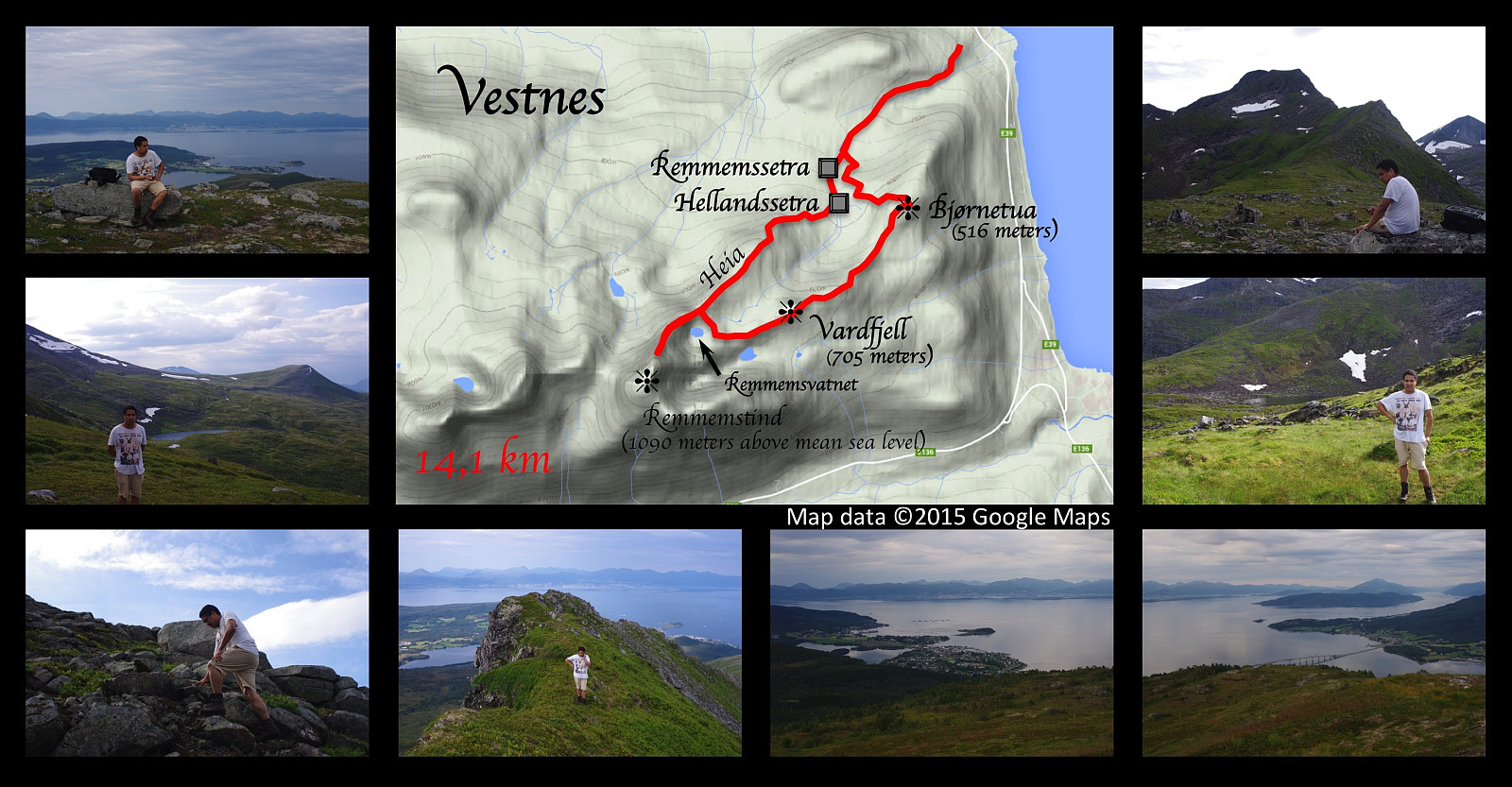 On this day Dag and I went to Vestnes, the village where my father grew up, and went hiking in some of the mountains of that area. We parked Dag’s car beside my grandfather’s old summer cowshed, which is still there; and started walking through the forest heading for the mountain. We reached the mountain peaks called Vardfjellet and Bjørnetua (705 and 516 meters above sea level, respectively), but the real summit of the area, called Remmemstind (1090 m.a.m.s.l.), we saved for another time; because that climb is really steep. To be honest, we actually did follow the northeast ridge of Mount Remmemstind up to about 1000 m.a.m.s.l. (Mount Remmemstind is 1090 m.a.m.s.l). At this point the ridge became too steep for us to climb since none of us had any real climbing experience at the time. >>>
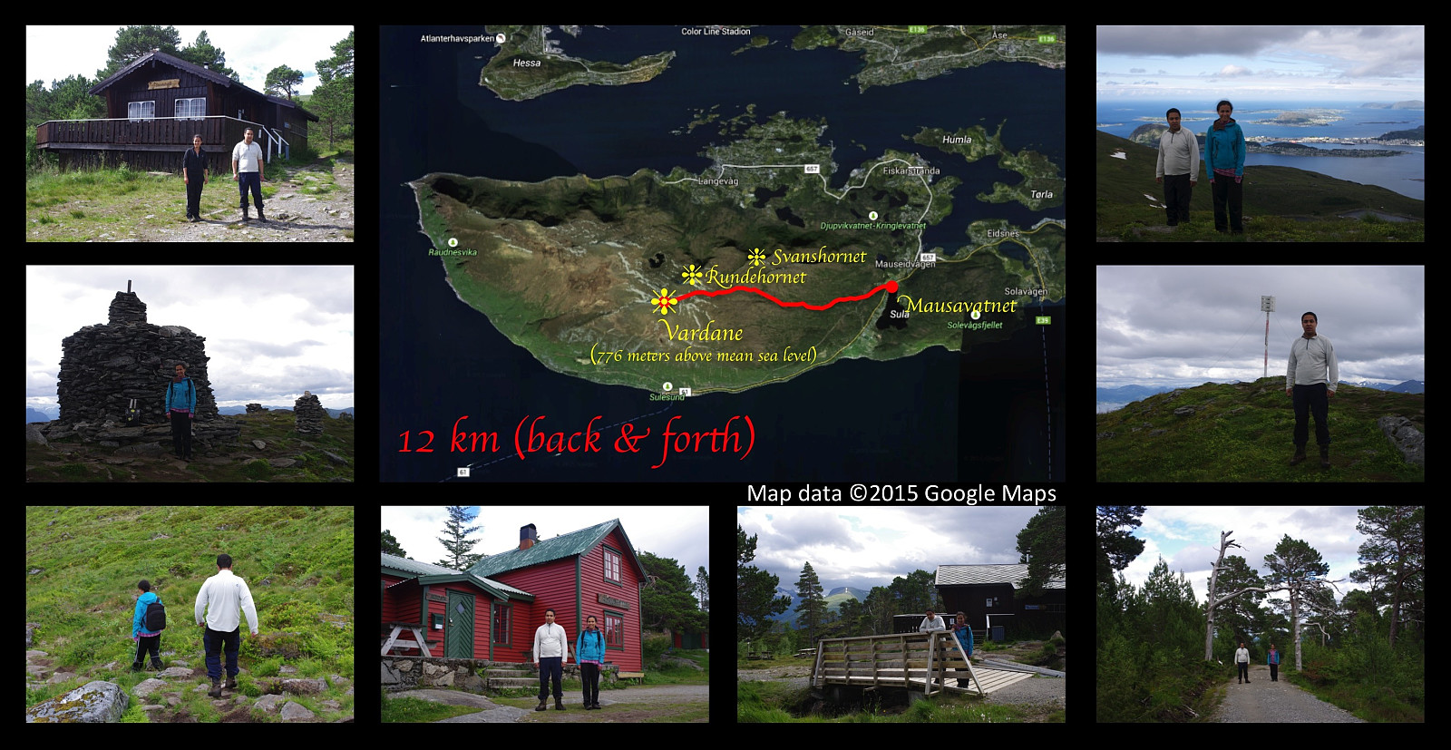
On Three Peaks of Mount Sulafjellet with my Son
- Date:
- 15.08.2015
- Characteristic:
- Hike
- Duration:
- 5:47h
- Distance:
- 16.9km
 I went for a cool trip on mount Sulafjellet along with my son Dag this afternoon. We started out from the parking place by the lake Mausavatnet as we've done on previous occasions, and walked past the well known mountain cabin Rollonhytta up to the mountain peak commonly reffered to as Vardane (776 meters above main sea level), though the real name is actually Tverrfjellet or just Sulafjellet from Sula, the name of the island on which the mountain is located [fjell = mountain]. We thereafter descended from Vardane as we headed towards another peak, Grøthornet, located 650 mamsl. From Grøthornet we descended quite a bit towards the village Langevåg, until we found a rather steep track that could take us up to the mountain peak called Svanshornet (552 mamsl). From Svanshornet we followed another >>>
Hiking Mount Sulafjellet with a son and a daughter.
- Date:
- 08.08.2015
- Characteristic:
- Hike
- Duration:
- 3:44h
- Distance:
- 12.0km
 I had on this day a really nice trip on the mountain Sulafjellet with my oldest son and my oldest daughter, aiming for the peak called Vardane. I also made the very same trip two months and two days earlier with my two sons and my cousin Savanna. On that day we had showers of hail and rain on the trip, and there was still a substantial amount of snow in the track. Even today we had just a very little bit of rain as we started on our descent back down from the mountain, but that didn't last for long; and the temperature was very different from what it was back in the beginning of june...
Hiking to "The Pulpit Rock" in Rogaland County
- Date:
- 03.08.2015
- Characteristic:
- Hike
- Duration:
- 1:18h
- Distance:
- 4.0km
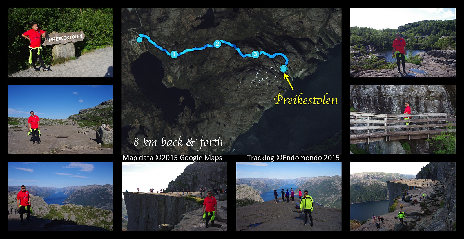 This afternoon I had a nice hike to the mountain plateau called The Pulpit Rock, in Norwegian Preikestolen. Weather was fabulous, it was actually so hot we needed to bring along a bottle of water each. It's a walk of about 4 km only (in each direction) from the parking area. Preikestolen is among the most famous tourist attractions in Norway, and has an estimated number of more than 200.000 visitors per year; hence a rather nice stone track has been made for the hikers, though it is, I have to say, a bit pebbled.
Hiking up Mount Ulriken in Bergen, Norway, with my son.
- Date:
- 02.08.2015
- Characteristic:
- Hillwalk
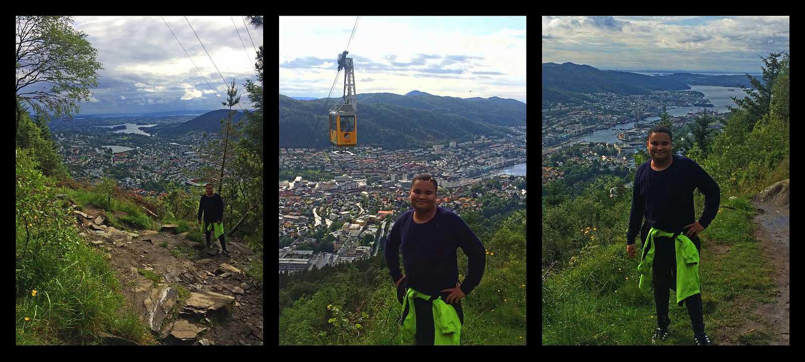 I went hiking on mount Ulriken in Bergen with my son Bror this afternoon. We had a really enjoyable trip, and weather was fairly nice most of the time, though we also had a shower of rain as we were heading back towards our new Bergen apartment. We climbed the mountain using a track just beneath the cable car that ascends the mountain. The lower part of the track goes through forest, and the upper part goes on bare mountain, with heather and moss as the only vegetation. We hiked up to the viewpoint where even the cable car takes the tourists. This isn't actually the highest point of this mountain massif, nor is it even the highest point of the part of the mountain that is known as Mount Ulriken, but it is the best viewpoint for an overview of the city, and it is the point that looks like it >>>
