Archive - Date
Archive - Activity
- Bike trip (2)
-
Climbing (8)
- Alpine climbing (7)
- Mixed climbing (1)
-
Other trip (1)
- Expedition (1)
-
Other winter trip (10)
- Snowshoe trip (10)
-
Ski trip (49)
- Randonnée/Telemark (49)
-
Trip by foot (234)
- Alpine trip (62)
- Hike (69)
- Hillwalk (90)
- Jogging (11)


Collected lists
-
Romsdal ≥ 100m pf.
(135/301)
 44%
44% -
Sunnmøre ≥ 100m pf.
(79/531)
14%
-
Norges 1000 største fjell målt i primærfaktor
(55/1000)
5%

Summiting Storhornet on Godøy Island twice in a day.
- Date:
- 20.06.2015
- Characteristic:
- Hillwalk
- Duration:
- 5:48h
- Distance:
- 17.6km
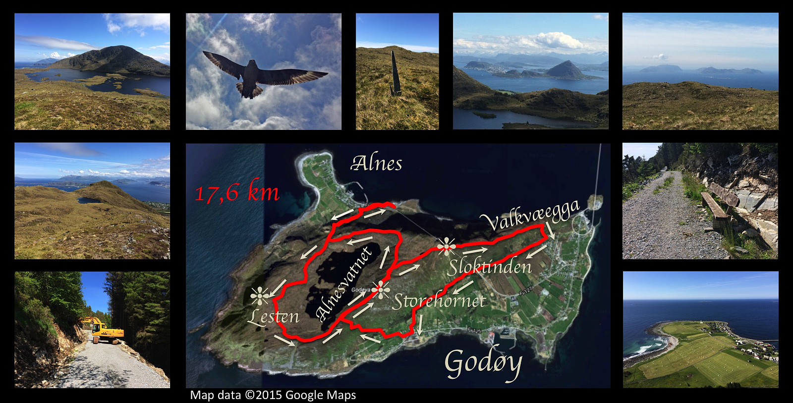 I had another nice hiking trip on the mountain of Godøy island this day. I started out from Alnes, and climbed up to the lake Alnesvatnet; then circumscribed the lake taking a track that I haven't used earlier. I had previously walked along the shore of the lake, and also over the mountain called Lesten, but this time I chose an in-between path about midway between the lake and the summit of Lesten, before ascending the final climb to the peak Storehornet, 497 meters above sea level. From Storehornet I went down the mountain ridge Valkvæegga to Valkvæ, and then westwards to Djuv on the south side of the mountain along a road under construction called Fjellfotveien (i.e. The Mountain Foot Road ). From Djuv I then climbed up to Storehornet a second time on this day, before finding my way down >>>
Round-trip on eastern part of the mountain of Godøy Island
- Date:
- 13.06.2015
- Characteristic:
- Hillwalk
- Duration:
- 4:43h
- Distance:
- 14.8km
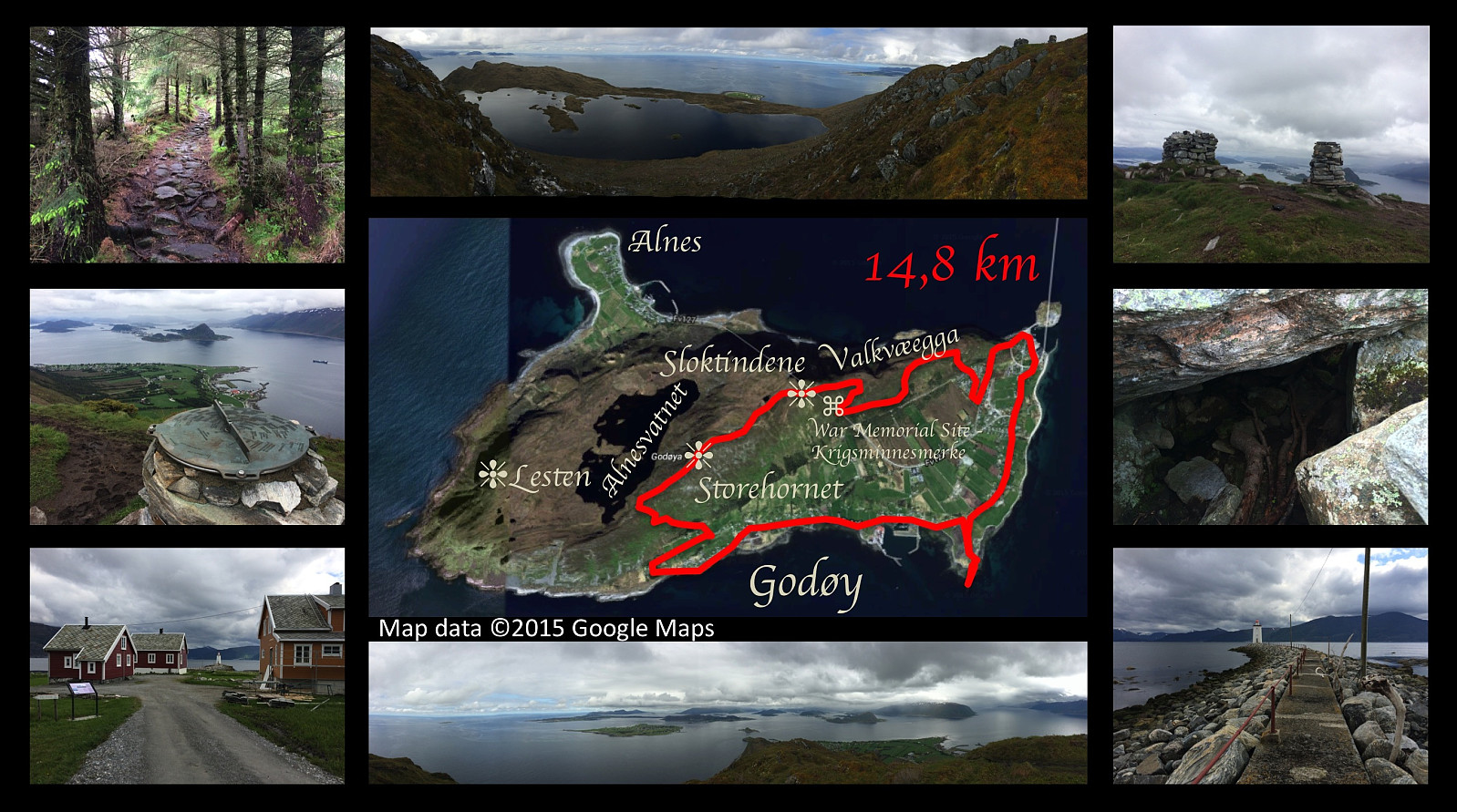 On this day I went for yet another hike on the mountain of the island Godøy, close to were we're living. This time I set out from a place called Djuv (or Juv) on the south side of the Island, and climbed towards the summit of the island, i.e. the peak called Storhornet. From Storhornet I took a somewhat peculiar way northeastwards, however, following first a little edge downwards to a viewpoint overlooking the southern and eastern parts of the island. From this spot I climbed back up to the pond called Lillevatnet, however, and then onto the peak called Sloktinden (there is actually about three peaks that are called Sloktindane [in plural form] by the locals, hence the singular form Sloktinden is something you're not likely to hear apart from here on Peakbook; anyway I climbed onto the easternmost >>>
Hiking Mount Sulafjellet with my cousin and my two sons.
- Date:
- 06.06.2015
- Characteristic:
- Hillwalk
- Duration:
- 6:27h
- Distance:
- 11.6km
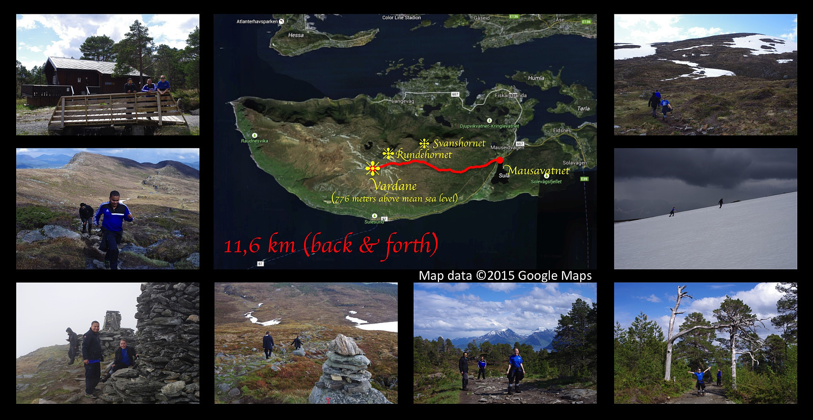 I went hiking on a very nice mountain trip on this day with my two sons Bror and Dag and my cousin Savanna . We set out from lake Mausavatnet, and climbed the mountain of the island Sula, located just south of Ålesund, up to its highest peak commonly called Vardane , 776 meters above mean sea level. The weather was nice with sunshine for most of our trip, but as we were approaching the summit, it changed within minutes to foggy, cold, rainy, and very windy; hence we were robbed of the nice view that we were anticipating to have at the peak of the mountain. I had planned to shoot a picture of Savanna and my boys with our home island of Vigra in the background, but that didn't work out... Being completly soaked by the rain, we couln't risk getting cold by waiting for the weather to improve, and >>>
