Archive - Date
Archive - Activity
- Bike trip (2)
-
Climbing (8)
- Alpine climbing (7)
- Mixed climbing (1)
-
Other trip (1)
- Expedition (1)
-
Other winter trip (10)
- Snowshoe trip (10)
-
Ski trip (49)
- Randonnée/Telemark (49)
-
Trip by foot (228)
- Alpine trip (57)
- Hike (69)
- Hillwalk (89)
- Jogging (11)


Collected lists
-
Romsdal ≥ 100m pf.
(134/301)
 44%
44% -
Sunnmøre ≥ 100m pf.
(78/531)
14%
-
Norges 1000 største fjell målt i primærfaktor
(52/1000)
5%

Encircling the western aspect of the Island Godøy
- Date:
- 24.05.2015
- Characteristic:
- Hike
- Duration:
- 4:47h
- Distance:
- 14.8km
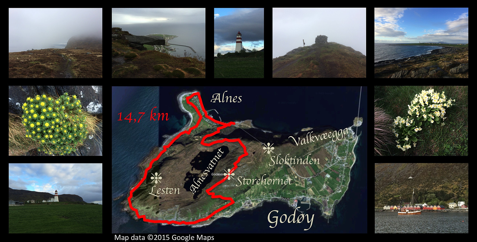 I had yet one hiking trip on the mountain of Godøy island this day. The weather was foggy and cold, and it was quite a wet experience; but I really needed to combust some calories after I attended the celebration of my mother's 70th anniversary the previous day. I climbed up from the promontory Alnes, up to the peak of Storhornet, then descended on the other side of the island, down to a place called Djuv. From there I followed the sea shore of the southern and western side of the island, back to Alnes. Due to the rough terrain, this part of the trip was definitely the hardest, despite the fact that the route mostly follows sea level. Upon arrival at Alnes, I followed the seashore around the promontory, and even stopped to shoot some photos of the picturesque lighthouse that is there. This >>>
A figure-of-8 hike on Godøy Island.
- Date:
- 16.05.2015
- Characteristic:
- Hillwalk
- Duration:
- 3:34h
- Distance:
- 11.1km
 On this nice day, I went once again hiking on the mountain of the island Godøy, taking a different route from what I had done before. As on previous trips I parked our car at Alnes, climbed up to lake Alnesvatnet, and crossed the island close to the shore of the lake; though I also took time to visit a little peninsula and a little island in the lake, before I started climbing up to the peak Storehornet. From the mountaintop, I descended along the mountainridge Valkvæegga for a distance, then took a track down to Godøy Primary School, and finally returned to my car at Alnes jogging through the tunnel. The tunnel runs from Støbakk on one side of the island, to Alnes on the other; and it runs just beneath the mountain peak called Sloktinden. It opened in December 2006, is about 1,5 km long; >>>
Hybrid-trip (bike and hike) to Mount Lyderhorn.
- Date:
- 14.05.2015
- Characteristic:
- Hike
- Duration:
- 1:46h
- Distance:
- 4.6km
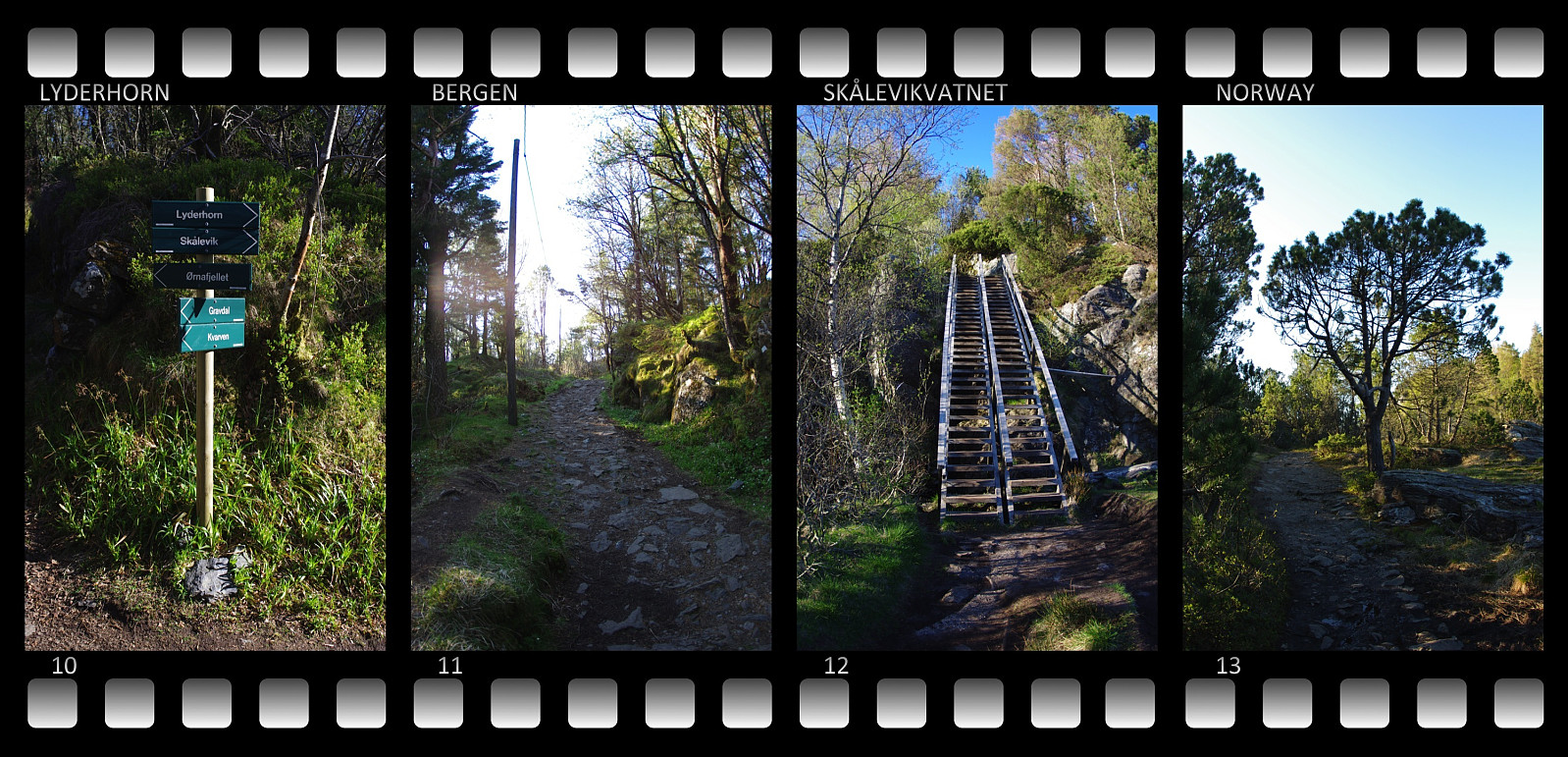 On this beautiful day in the month of May I had a splendid afternoon/evening trip up to the summit of mount Lyderhorn just west of the city of Bergen. I went by bicycle as far up as possible, to an altitude of about 212 meters above sea level (blue line on the image above); where I locked the bike to a fence and continued on foot (red line on the image). There is actually a narrow, but nice road up to a military installation at this altitude, quite nice for bicycling. A forest track then leads a few metres ahead to an escarpment, where some nice stairs have been built, that'll take you down to a lake or a pond called Skåleviksvatnet. From there a mountain track leads right to the summit of the mountain. The summit is located at an elevation of 396 meters. Had wonderful weather conditions, >>>
A larger round trip of the mountains of the Island Godøy.
- Date:
- 09.05.2015
- Characteristic:
- Hillwalk
- Duration:
- 3:55h
- Distance:
- 12.9km
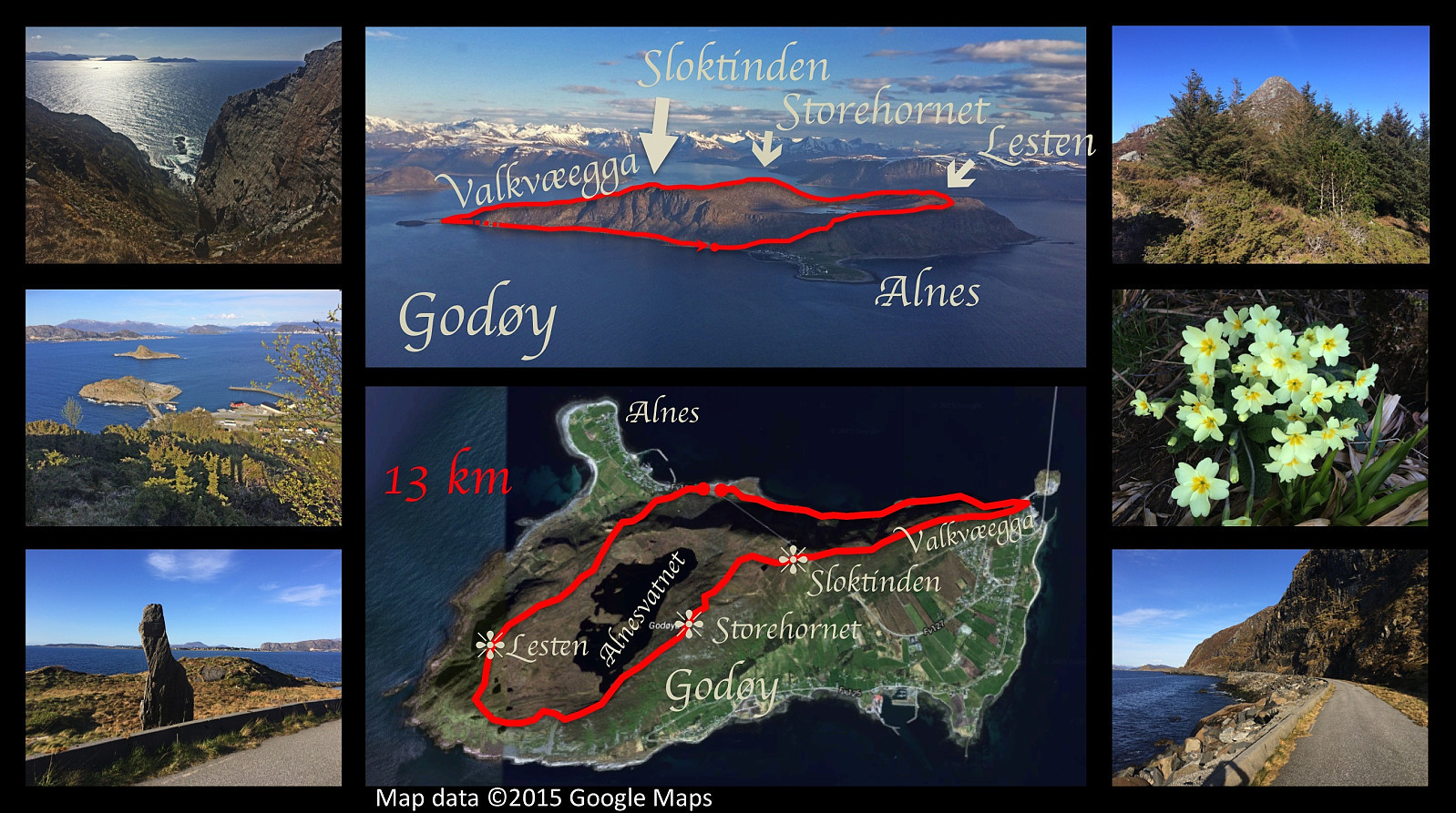 On this day we had extremely nice weather in the area, and so I had another really nice trip on the mountain of the island Godøy. I first climbed the rather steep climb from the headland/ness called Alnes up to Lake Alnesvatnet, located on a platau about 250 meters above mean sea level. Then a not-so-steep walk to the peak of mount Lesten (altitude 357 meters), from there almost down to the other end of Alnesvatnet, and directly onto a very steep climb up to the peak of Storehornet (497 meters), next onto the peak of Sloktinden (436 meters), and then all the way down to sea level again along the mountain ridge called Valkvæegga. I finally walked the old Alnes road back to Alnes where I had my car parked.
A round trip on the mountain of the Island Godøy.
- Date:
- 02.05.2015
- Characteristic:
- Hillwalk
- Duration:
- 3:32h
- Distance:
- 10.3km
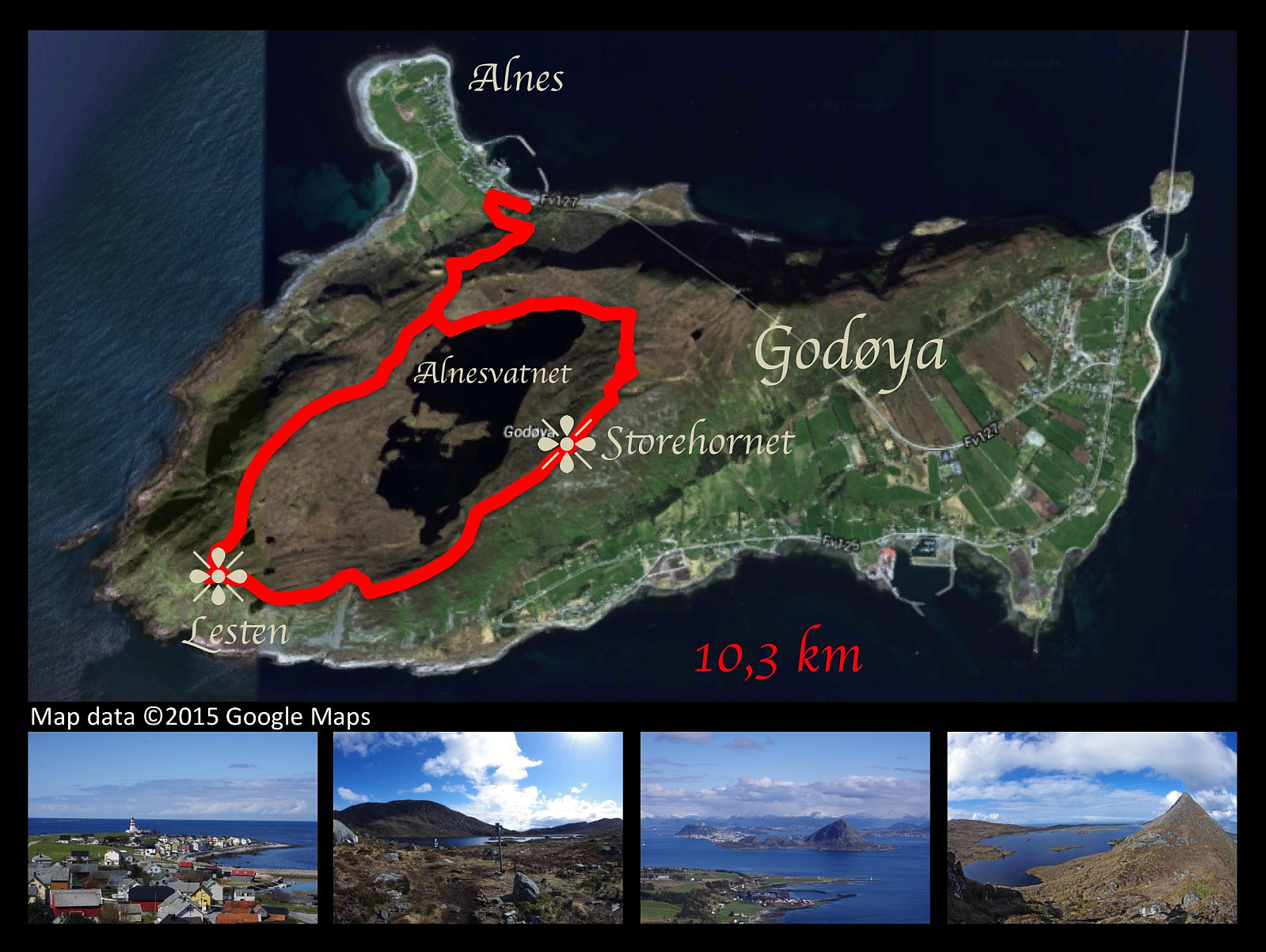 On this day I had a nice trip walking the mountains of Godøy Island. Weather was nice, and the scenenery was picturesque. The climb from the promontory of Alnes is rather steep to begin with, but you then reach a plateau at about 250 meters above mean sea level, on which is located a lake called Alnesvatnet. This lake is ideally located as a drinking water reservoir for the entire municipality of Giske, which is constituted of four inhabited islands along with a number of uninhabited islets. The lake is located substantially higher than any of the inhabited areas of the municipality, hence there's sufficient water pressure to reach all the houses in need of water. Once on the plateau, you walk along Alnesvatnet to its eastern end, and then you follow the track up a rather stony mountain edge >>>
