To Mount Slogen with my Two Daughters (30.07.2016)


| Start point | Øye (50m) |
|---|---|
| Endpoint | Øye (50m) |
| Characteristic | Alpine trip |
| Duration | 8h 03min |
| Distance | 8.8km |
| Vertical meters | 1,588m |
| GPS |
|
| Ascents | Slogen (1,564m) | 30.07.2016 |
|---|---|---|
| Visits of other PBEs | Slogen - p-plass (50m) | 30.07.2016 |
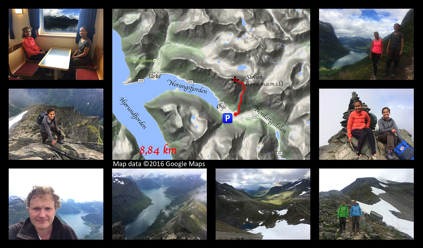
In order to get to Mount Slogen from where we live, you have to cross the fjord called Storfjorden [i.e. “The Large Fjord”], and so on this occasion I went by car with my two daughters to a place called Magerholm; from where we crossed the fjord by ferry, arriving at a headland called Ørsneset, not far from the village of Sykkylven. From Sykkylven we continued our drive to the village of Stranda, then on to the village of Hellesylt; and finally a few kilometres after we had passed Hellesylt, we took the road to the right, which took us down to a fjord called Nordangsfjorden, a side arm of the beautiful fjord of Hjørundfjorden.
We parked at a parking lot at a place called Øye, and immediately embarked upon our climb. The climb up Mount Slogen is quite steep all the way from the beginning to the summit, but the trail is readily visible, and quite well marked. The first part of it goes through birch forest, but gradually vegetation becomes scarcer; and after a transition zone with only grass, heather and moss, you eventually have only rocks with some scattered lichen on them in the upper part of the trek. The climb is about 4 and a half kilometer long, and the first three kilometers or so goes along a mountain ridge in a north-south direction (and you’re trekking in a northward direction along this ridge). This mountain ridge takes you right up to the edge of another, much larger, but not so steep ridge; and at this point the trail is joined by an alternative trail, a trail that you would’ve been using if you had decided to climb the mountain from Liadalen Valley. A lot of people actually choose to do just that, as by taking that route they avoid the steep climb from Øye up to this eastern ridge of Mount Slogen. The trail from a spot called Liasætra in a valley above the village of Stranda is more like a long walk, apart from the final 3 kilometers up to the summit of Mount Slogen, which is common to both routes. The trail from Liasætra to the summit of Mount Slogen is 9.3 kilometers or so, hence about twice as long as our trail; but a common thing to do if you opt for that route, is to go from Liasætra to a cabin called Patchellhytta, (a 6.3 km long trek with a climb of about 700 elevation meters), and then spend the night at this cabin, before you climb up to the summit of Mount Slogen the next morning.
As we reached this eastern ridge of Mount Slogen, we knew the trail up to the summit of the mountain was the one to the left; and that the one to the right was the one down to Patchellhytta Cabin. (The cabin is located at 818 m.a.m.s.l., whereas we were already at 1190 m.a.m.s.l.). The climb up the final ridge towards the summit was not as steep as the climb that we had endured till now; apart from the 50 final elevation meters before the summit, which are indeed quite steep. We had to walk on snow two or three places; snow that had still not melted away despite of the summer; but otherwise this part of the trail was uneventful. As we arrived at where the final steep climb towards the summit starts, we met a woman that was waiting for her family to return from the summit; she had encouraged her family to climb all the way up, while declining to do so herself, as she thought it was a bit too steep for her. I've also heard of people that have had to leave their dog waiting for them at this point, as the dog has refused to continue up to the summit from here. This depends on how used the dog is to such steep climbing, though, as I also know of people that have dogs that have joined them for even steeper climbs than this. Nevertheless, it gives you an idea as to how steep this latter part of the climb is; according to an inclination map that I have, the inclination of this steepest part of the trail is between 41 and 45°.
We reached the summit without any special events, and had a little to eat and drink before embarking upon our descent. As we started descending, it started raining a little; not enough to make us wet, but enough to make the stones and rocks slippery; and so at places we had to sit down, and slide carefully on our bums for a few meters, instead of climbing in a more normal fashion. We did get down without hurting ourselves, however, and the rest of our descent back down to the car was rather uneventful.

User comments