To Mount Urfjellet with my Son Dag (16.07.2016)


| Start point | Slyngstad (70m) |
|---|---|
| Endpoint | Slyngstad (70m) |
| Characteristic | Hike |
| Duration | 3h 25min |
| Distance | 10.7km |
| Vertical meters | 885m |
| GPS |
|
| Ascents | Urfjellet (840m) | 16.07.2016 |
|---|---|---|
| Visits of other PBEs | Slyngstad p-plass (70m) | 16.07.2016 13:21 |
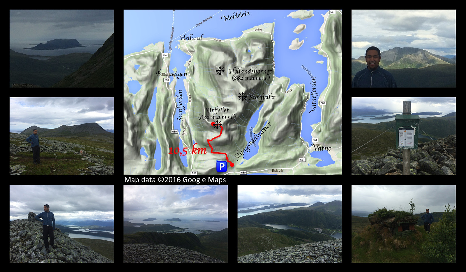
Just outside the little village of Slyngstad, you'll find an old road over Mount Remefjellet, and then down to the fjord called Samfjorden on the other side of the mountain (see map). This old road was once upon a time the main road to the village of Brattvåg. Later on, however, a new road was built, with a tunnel through the mountain; and the old road is now no longer being maintained, and it is now mainly used by tour walkers and mountain trekkers. Tour walkers are actually still using the entire length of the road to get from one side of the mountain to the other; whereas for the mountain trekkers about half of it has become the first leg of the trail up to Mount Urfjellet [839 m.a.m.s.l.] and Mount Storfjellet [950 m.a.m.s.l.].
My son and I parked our car at a little parking lot at Slyngstad, and started walking up the old mountain road. As there's no longer any maintenance work being done on the road, you cant drive along it by car, unless you have a 4WD with a good ground clearance. [And at one bend of the road, even a huge power pole has been erected in the middle of the road; so at that spot you may even need an ATV to get around that one]. Nevertheless, for a mountain trekker, the old road is still much better than most mountain trails: It might be more boring to walk along, for sure; but you move much more quickly along it, than what you do along most trails in the mountain.
The road is actually following a valley between Mount Urfjellet and the much lower Mount Øygardsheia [399 m.a.m.s.l.] just south of it. The road reaches its highest point of elevation at about 270 m.a.m.s.l., and as you're approaching that point, you have to be aware and look for the trail up to Mount Urfjellet on the right side of the road, so that you don't walk past it.
My son and I left the road at the appropriate spot, and followed the mentioned trail, which have been very well marked by red spots on stones along the route. The trail at first goes through a not very dense birch forest, and the birch trees even gradually become more scattered; until you're walking through a landscape with heather, moss and stones with lichen. As you get even higher up, the heather gradually disappears, and the landscape become more stony, until you only walk on stones with a little lichen. We soon reached the summit of the mountain, where we shot some photos, before embarking upon our return back down. It's especially in the upper part of the trail that the red dot marking is useful, as the trail itself becomes less visible when there's less vegetation.
This peak is sure not the highest one in this area, but it offers a marvelous view over nearby fjords, mountains, peninsulas and islands.

User comments