Two Trips to Mount Storehornet on Godøy Island (02.01.2021)

| Tourlänge | 2h 14min |
|---|---|
| Entfernung | 6,9km |
| Höhenmeter | 768m |
| GPS |
|
| Besteigungen | Storhornet (497m) | 02.01.2021 |
|---|---|---|
| Storhornet nordøst (477m) | 02.01.2021 16:06 |
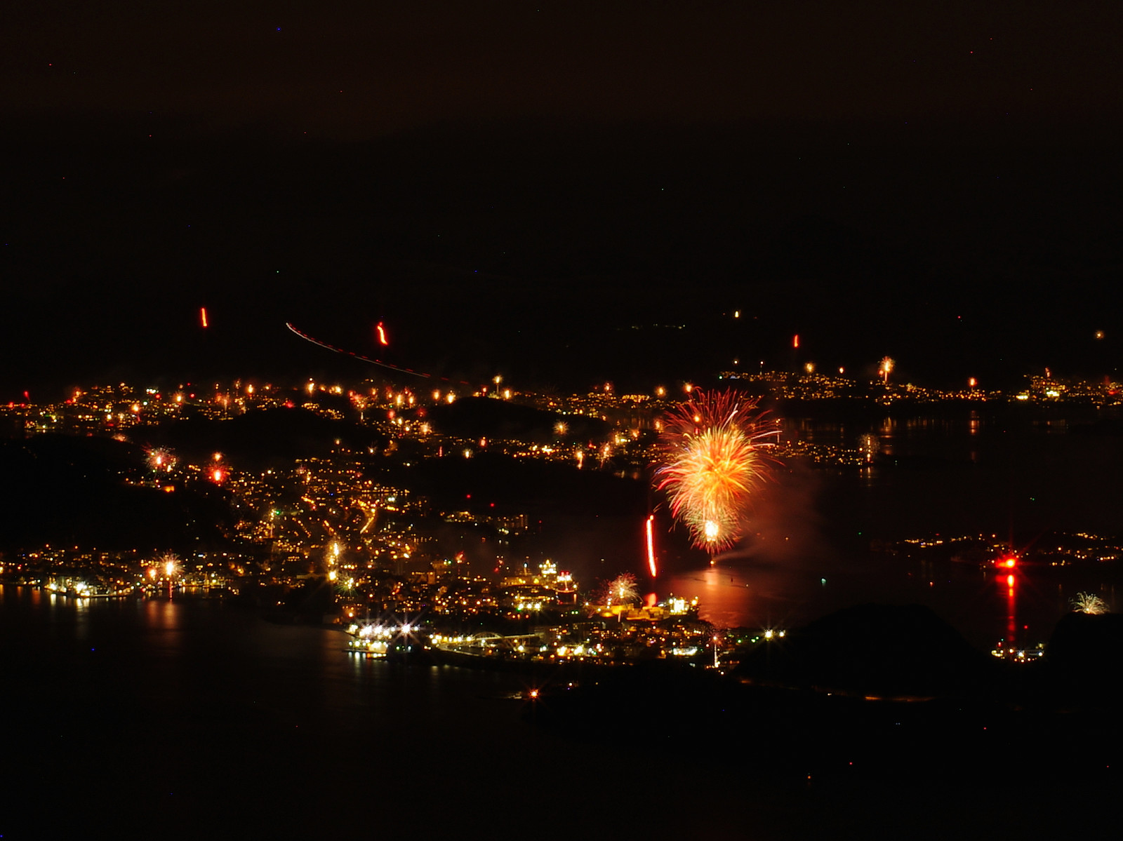
Mount Storehornet on Godøy Island is a mountain that I have frequently climbed. I usually don't publish my climbs of that mountain here on Peakbook, as I've climbed it so many times. I have, however, been having an idea of photographing the Norwegian costal town of Ålesund at the entrance to the Georgian New Year, as the people of this town usually have a spectacular firework at this time of the year. And so, in late evening of December 31st, I climbed the mountain again, this time carrying a backpack with a camera and some lenses, along with a tripod; planning to capture some long exposure photos up there. I sat out from the parking lot just outside the tunnel opening at the peninsula of Alnes shortly before 11 o'clock in the evening. Usually, an hour is plenty of time to climb the mountain, but with a heavy backpack, and some snow in the upper part of the mountain; I had to realize after a while, that I was running out of time if I wanted to reach the summit of the mountain before midnight. The mountain has a second peak, just northeast of the summit, however; and when you climb the route that I was following, you actually pass very close to this peak. And so, as I was just about to continue past the north east peak of mount Storehornet, it came to my mind that the view towards the town of Ålesund from this peak is actually even better than the view from the main peak. And, so, I just climbed the few meters up to this peak, rigged my tripod; and mounted my camera onto it. I shot 9 photographs while up there, all of them using an aperture opening of f22, and an exposure time of 30 seconds. Due to the wind, my camera was shaking a bit, and only one of the images turned out reasonably well. Moreover, an exposure time of 30" is a bit too short to get a lot of firework into the image; hence the photo (image #1) mainly became a photo of the official firework in the centre of the town. Had there been less moonlight, it would've been possible to make the exposure time even longer; allowing much more firework into the picture. Ålesund is a costal town with a lot of seafarers that have access to emergency flares, which they use as firework at new year's night; although that's not exactly legal. Nevertheless, 30 seconds is also the maximum exposure time on my old Pentax K5-IIs; so next time there's nice weather on new year's eve, I have to be better prepared, and have a wired remote control with me, as that would allow me to shoot images with exposure times of 5 or 10 minutes etc.
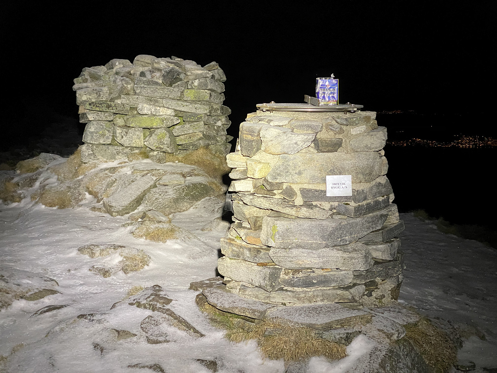
While I was standing on the northeast peak of Mount Storhornet shooting long exposure images, I suddenly heard and saw fireworks on the neighboring peak, i.e. the summit of Mount Storhornet. After a while the fireworks ceased, and I packed my camera back into the backpack, and attached the tripod onto the backside of the backpack; and then walked over to the summit of the mountain. When I arrived there I saw a burnt-out fireworks battery pack still standing on top of one of the two large cairns that have been built up there. Then suddenly I heard the voice of a women in the darkness a few meters from me wishing me "happy new year". While climbing the mountain, I had been thinking I was going to be alone on top of the mountain this evening, as most people tend to go partying on new year's eve; but there I was wrong: Just beneath the summit this young couple was still sitting in the lichen, admiring the remaining fireworks that could be seen from up there, though by now it was all quickly abating.
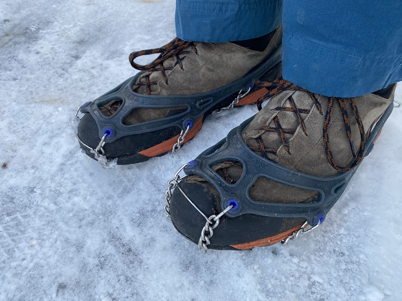
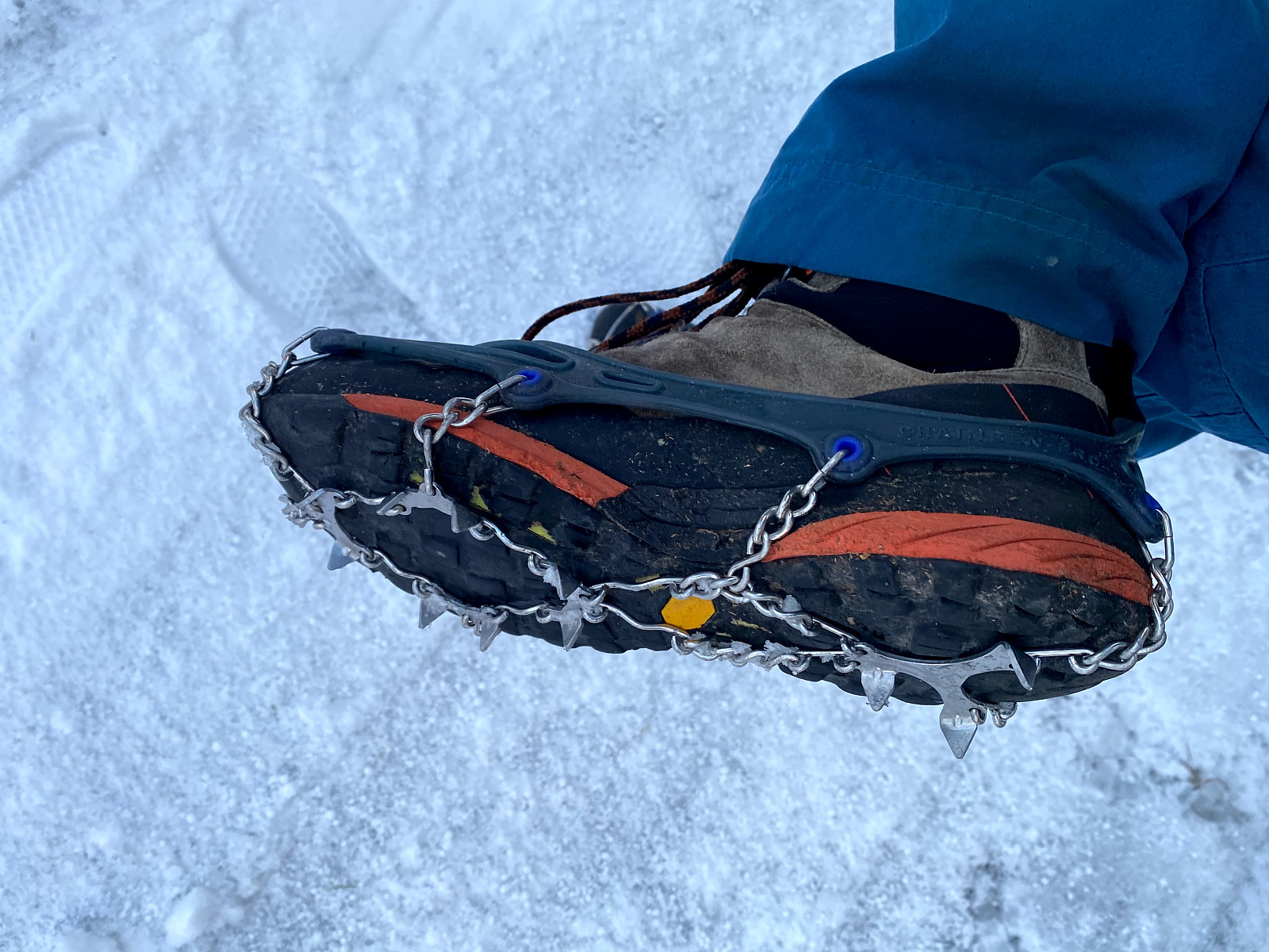
Before embarking upon my descent from the mountain, I put on a set of Snowline™ Crampons that I had just purchased (Images # 3 & 4), and that I wanted to test out. The ground had been bare and dry up to about 300 m.a.m.s.l.; but from there up to the summit, there had been snow about 5 cm deep, some of it hard packed, and here and there a bit icy. Climbing without slipping and falling wasn't that hard, but in conditions such as these it's usually more challenging to remain on both feet at the time of the descent, than at the time of the ascent. And the crampons didn't disappoint: I remained on my feet all throughout the descent of the upper part of the mountain. At 300 m.a.m.s.l., I was below the snow; and could remove the crampons. Two days later, i.e. on January 2nd, I climbed Mount Storhornet once more. By now there had been a new snowfall, and so there was snow all the way from the parking lot at 5 m.a.m.s.l. up to the summit of the mountain. So, here I had a new opportunity to to test out my crampons; and even on this day I was extremely satisfied with them: I could walk much faster that I usually have been able to on such a layer of snow, and especially so when descending from the mountain again. Moreover, on this day, I met some other mountain trekkers, who were heading back down from the mountain as I was climbing up; and you could readily see that they were struggling quite a bit on the slippery ice and snow; whereas with my crampons on I had no problems when I descended about an hour later.
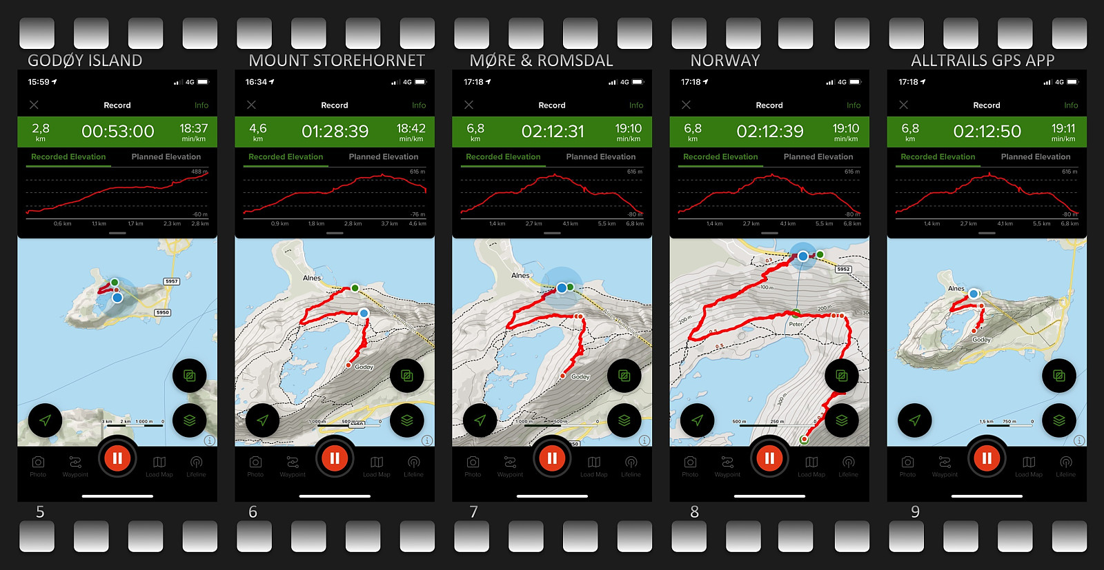
The new crampons wasn't the only thing I was trying out on this day, however; as I was also trying out a new gps app on my iPhone. The Endomondo App, which I had been using for year to track my trails, had been closed down on December 31st; and so I hadn't had any app to track my climb on new years eve with. [I could of course have used my Garmin inReach device, but I simply didn't think of bringing it with me]. Before my climb on January 2nd, I downloaded an app named Alltrails (Images ##5-9). I was of course only able to try out some basic features on such a short hike. Nevertheless, the app seems promising. A feature that I did enjoy was the possibility to keep an eye on the elevation of your trek, as this map has an elevation diagram above the track map (see upper part of the images ##5-9); a feature that I've been missing on the Endomondo app. So, until I have money to purchase a nice gps watch from Garmin, I'll probably use this Alltrails app for mountain trekking (whenever I don't have my inReach device with me), and maybe the Mapmyrun app for my jogging and running trips. Anyway, on this beautiful January day, I got up and down again from Mount Storhornet without any struggle, and I even shot some beautiful winter images with my cellphone during the hike (Images ## 10 & 11).
![Image #10: Lake Alnesvatnet [254 m.a.m.s.l.] in the twillight on January 2nd.](https://images1.peakbook.org/images/14939/Solan_20210105_5ff4ddb8107e3.jpg?p=xtralarge)


Benutzerkommentare