Hiking to Mount Blåskjerdingen with my Sister (02.07.2016)

| Start point | Vatnedalen (214m) |
|---|---|
| Endpoint | Vatnedalen (214m) |
| Characteristic | Hike |
| Duration | 5h 04min |
| Distance | 9.8km |
| Vertical meters | 1,567m |
| GPS |
|
| Ascents | Blåskjerdingen (1,069m) | 02.07.2016 |
|---|---|---|
| Søre Blåskjerdingen (1,061m) | 02.07.2016 | |
| Visits of other PBEs | Blåskjerdingen p-plass (214m) | 02.07.2016 |
My sister is living in another part of our beautiful country, but whenever she's visiting our part of the country, she frequently asks me to take her on some mountain trip. Now, I don't dare to take her on the steepest and most challenging climbs, so when she asks me for that, I say to her, just as when we were kids: "No, you're too young...!" Nevertheless, I considered that she would do quite well with Mount Blåskjærdingen, so on this day we agreed to go there. Now, Mount Blåskjerdingen has two summits, with a characteristic V-shaped cleft in between them; and this actually makes it quite easy to spot the mountain even from afar.
We parked our car at a parking lot in Vatnedalen Valley (see map). Her on Peakbook this parking lot has actually been named after the mountain, i.e. you'll find it as Blåskerdingen P-plass, and from there we started hiking. The trek up to the first, or southern summit is quite straight forward. You start out on a graveled forrest road, then you continue on a forrest trail, which takes you up the mountain side. As you gain altitude, the trees become scarce and the forrest comes to an end. You then follow a mountain ridge where the main vegetation is heather, lichen and moss; and for the last 200 elevation meters or so, there's only stones with a little lichen and moss on them.
The two summits of this mountain are 1061 m.a.m.s.l. and 1069 m.a.m.s.l., respectively. The names of the two peaks vary a little depending on who you ask. Here on Peakbook the north peak is called Blåskerdingen, and the south peak is called Blåskjerdingen Sør [sør=south]; but some of the locals living in the surrounding area actually reserve the name Blåskjerdingen for the north peak, and refer to the south peak as just Skjerdingen. The road sign down by the parking lot just reads Skjerdingen, without any specification as to which of the two peaks it refers.
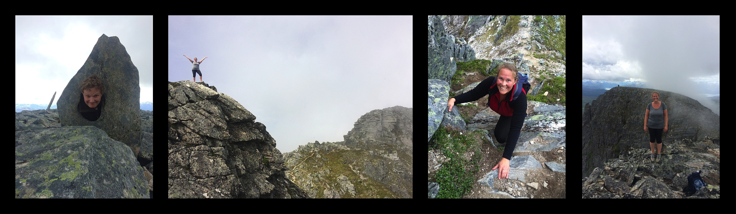
When you arrive at the plateau of the south peak of the mountain, you may encounter some funny slate-like stones with holes in them; just a few meters to the right of the trail (Image #1). From there, it's just a short distance to the huge cairn that have been built on this peak.
The cleft between the two summits of the mountain is about 35 meters deep with steep mountainsides leading into it. During the summer months climbing down into the cleft, and then up to the top of the north peak is feasible if you have some experience with trekking and light climbing in the mountains. During winter, however, that would be quite challenging. You might do it using crampons and an ice axe if you're experienced with the use of such equipment; but most people don't do that, and so when tour skiing to the top of this mountain, we're usually content with visiting the south peak [i.e. the one called Skjerdingen].
Anyway, since our current visit was in July, my sister and I continued into the cleft, and onto the north peak (Images ##3 & 4). Thereafter, we climbed back to the south peak, and hiked back down to the car along the same route as we had ascended.
It is also possible to descend in a northward direction from the north peak of the mountain. For a description of such a tour, you may go to my tour description at Hiking to Mount Skjerdingen and Two Beautiful Lakes.

User comments