Hiking to Mount Trolltind from Tomresetra with my Son Dag (18.06.2016)

| Start point | Tomresetra (300m) |
|---|---|
| Endpoint | Tomresetra (300m) |
| Characteristic | Hike |
| Duration | 4h 34min |
| Distance | 10.4km |
| Vertical meters | 1,599m |
| GPS |
|
| Ascents | Middagsfjellet (902m) | 18.06.2016 14:49 |
|---|---|---|
| Trolltinden (1,170m) | 18.06.2016 14:49 | |
| Visits of other PBEs | Seterveien p-plass (300m) | 18.06.2016 14:49 |
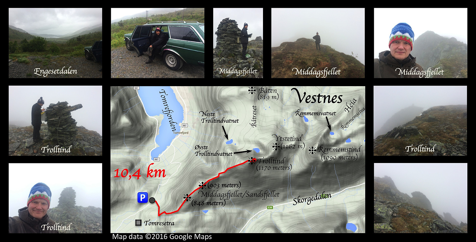
Mountain hiking to Brustind (1170 m.a.m.s.l.) with my son Dag on this day. We chose a different outset from what I did when I climbed this mountain on November 1st last year, allowing us to climb even the mountain Middagsfjellet on our way up. The literal meaning of the name "Middagsfjellet" is the "Mid-Day Mountain" or the "Noon Mountain", a name probably applied to the mountain because of its location just south of the village Tomra by the fjord Tomrefjord. At 12 o'clock the sun would be standing just above this particular mountain (for an observer in Tomrefjord); hence the inhabitants in Tomra used the mountain to mark out the time for noon back in the old days when common people didn't go around wearing watches.
This hike isn't too steep. The first part goes through birch forrest, but then the trees becomes more scarce, and thereafter heather, moss and lichen is the only vegetation. The trail across Mount Middagsfjellet is visible, and easy to follow all the way. Once you've embarked upon Mount Trolltind [i.e. The Troll's Peak], however, the route soon becomes stony, and the trail is more difficult to follow. In the top area there are two cairns; one marking the summit proper, and the other one located a little bit west of the summit. The mailbox with the book in which you may register your ascent is on the large, western cairn. There's a ravine between the two cairns that you don't want to fall into. In fair weather, as on this day, you may go all the way to the summit proper, whereas when it's icy and snowy, and maybe blowing, it is often wise to stop at the western cairn, which is the one at which you arrive first. Moreover, during winter a snow shelf may form, that may actually cover the ravine, so that you won't even know that you're waking upon thin air, so to say. According to what I've been told, they actually built the large cairn, and placed the book there, in order to prevent people from challenging destiny by going all the way to the second cairn when conditions weren't good.

User comments