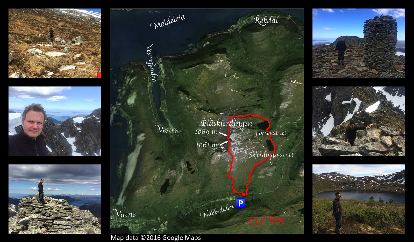
Upper left image: On our way up the south face of Mount Skjerdingen. Upper right image: My son Dag the cairn on the southern peak of Mount Skjerdingen (1061 m.a.m.s.l.), with the northern peak (i.e. the summit) in the background. Middle left image: Me on the southern peak, with the notch and the northern peak in the background. Middle image: Our gps-tracking on a Google Map satellite image. Middle right image: Climbing out of the notch unto the northern peak of Mount Skjerdingen. Lower left image: My son on the summit/northern peak of Mount Skjerdingen (1069 m.a.m.s.l.). Lower right image: Lake Forsevatnet.
On this occasion, my son Dag and I went hiking to the mountain Blåskjerdingen. This mountain has a deep cleft that runs right through the top of the it; giving it two separate summits and a quite characteristic appearance that makes it easy to spot, even from a pretty long distance. We parked our car in a nearby valley called Nakkedalen, and made our climb to the first summit of Blåskjerdingen, which has an altitude of 1061 m.a.m.s.l. From there you look straight across the deep cleft onto the other summit, not even 50 meters away from you, and with an elevation of 1069 m.a.m.s.l. [Note: The names Skjerdingen and Blåskjerdingen are used interchangeably by many, but the local population in the villages at the foot of the mountain tend to refer to the higher (northern) summit as Blåskjerdingen, and the lower (southern) summit as Skjerdingen]. The climb down the steep mountainside into the rather narrow rift, and then up again on the other side of it, was one of the most spectacular things I had ever done in mountain hiking up to that time. It’s difficult to describe the feeling that you have when standing on top of the higher of the two summits of the mountain, with a free view to a very large part the county of Møre & Romsdal. For the decent from the mountain we followed a mountain ridge that led in a northward direction, and then another ridge that took us eastwards, down into a hidden valley with a beautiful lake, and a really breath-taking waterfall. We encompassed the lake, and climbed up alongside the waterfall, then kept on along a second lake; before crossing a lovelyl heathland on our track back to the car.


Kommentarer