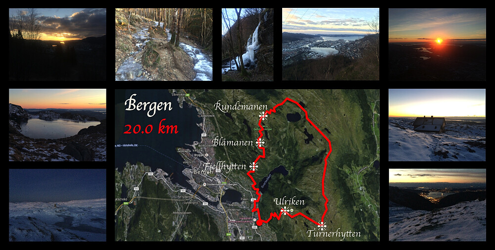
A 2nd Trip Across Mount Ulriken, Rundemanen and Blåbanen (06.01.2016)


| Start point | Haukelandsbakken (115m) |
|---|---|
| Endpoint | Haukelandsbakken (115m) |
| Characteristic | Hike |
| Duration | 6h 43min |
| Distance | 20.0km |
| Vertical meters | 1,190m |
| GPS |
|
| Ascents | Blåmanen Vest (552m) | 06.01.2016 14:26 |
|---|---|---|
| Søre Midtfjellet (452m) | 06.02.2016 | |
| Ulriken Vest (607m) | 06.02.2016 |
Whenever I'm going to be on call during the weekend at my work as a medical doctor and a cardiac surgeon at our hospital in Bergen, I have the advantage of having a day off on Wednesday prior to that weekend. This was such a Wednesday, and I had decided to make the most of it; and so I set out for a long trek. Having a hike like this is actually a very nice way to seek recreation prior to three days of being continuously on call.
Nature is actually quite beautiful upon the Bergen mountains. It was, however, a rather frozen landscape that met me in the mountains on this particular day. It was still beautiful, but it was beautiful inn a different way. I climbed Mount Ulriken as I've done on multiple occasions, and then from the west peak of Ulriken, I went south east, to a cabin called Turnerhytten [i.e. The Gymnasts' Cottage]. From this cottage, which is, as the name indicates, owned by Bergen's Gymnastics Association, you take directly north in order to head for Mount Rundemanen. About three kilometers after you've passed The Gymnasts' Cottage, you arrive at Borgeskaret, a narrow pass that was once used by post men on horse back to get from Bergen to Arna, which was the first leg on the long post route between Bergen and Oslo. When you're travelling perpendicular to the old post route, however, as I did on this day, the pass just becomes a 35 meter deep furrow that you have to descend into, and then climb out of, before you can continue. The route then takes a more north western direction along another mountain ridge, and it has been thoroughly marked by huge cairns all along the way, to prevent people from getting lost whenever the weather is foggy. On this day I had nice weather all along the route, however. As you approach a lake called Øvre Jordalsvatnet, there is a rather steep descent, as you're climbing down from about 580 m.a.m.s.l. to about 470 m.a.m.s.l. in just about half a kilometer. The trail continues along Øvre Jordalsvatnet for about half a kilometer, and then, after another half a kilometer, you need to take the trail to the left, if you want to continue onto Mount Rundemanen, as the trail that continues straight ahead will take you down into the valley called Jordalen. The trail next takes you around a mountain knoll called Ranen (498 m.a.m.s.l.), and after you've passed that knoll, you'll see the summit of Mount Rundemanen, unless the weather is pretty bad. At this point, you'll meet the mountain path coming from lake Tarlebøvannet and the valley Våkendalen, and this path has been prepared for bicycles and strollers etc., hence the last part of the way up to Mount Rundemanen is actually pretty nice. I continued across Mount Rundemanen (though I didn't actually bother to walk over to the highest point of Rundemanen, as that was a detour), and then I left the nice path to continue onto Mount Blåmanen, which is actually part of the same large mountain as mount Rundemanen (it has a vertical seperation from Mount Rundemanen of only about 40 meters), but which has traditionally been regarded as a separate mountain by the people living in Bergen. From Mount Blåmanen I descended southwards along a mountain ridge over a peak called Søre Midtfjellet, down to the dam called Svartediket in the valley Ulriksdal, and from there I continued back up to my Bergen apartment close to the hospital where I'm working.


User comments