Arkiv - dato
Arkiv - aktivitet
-
Annen vintertur (3)
- Trugetur (3)
- Fottur (137)
-
Kjøretur (1)
- Biltur (1)
-
Klatring (23)
- Alpin klatring (9)
- Sportsklatring (11)
- Via ferrata (2)
-
Skitur (62)
- Fjellskitur (3)
- Langrennstur (1)
- Randonnée/Telemark (58)


Lister jeg samler etter
-
Norges 1000 største fjell målt i primærfaktor
(45/1000)
 4%
4%

Favoritturer
Favorittopper


Roalden
- Dato:
- 10.09.2018
- Turtype:
- Fjelltur
- Turlengde:
- 3:30t
- Distanse:
- 6,8km
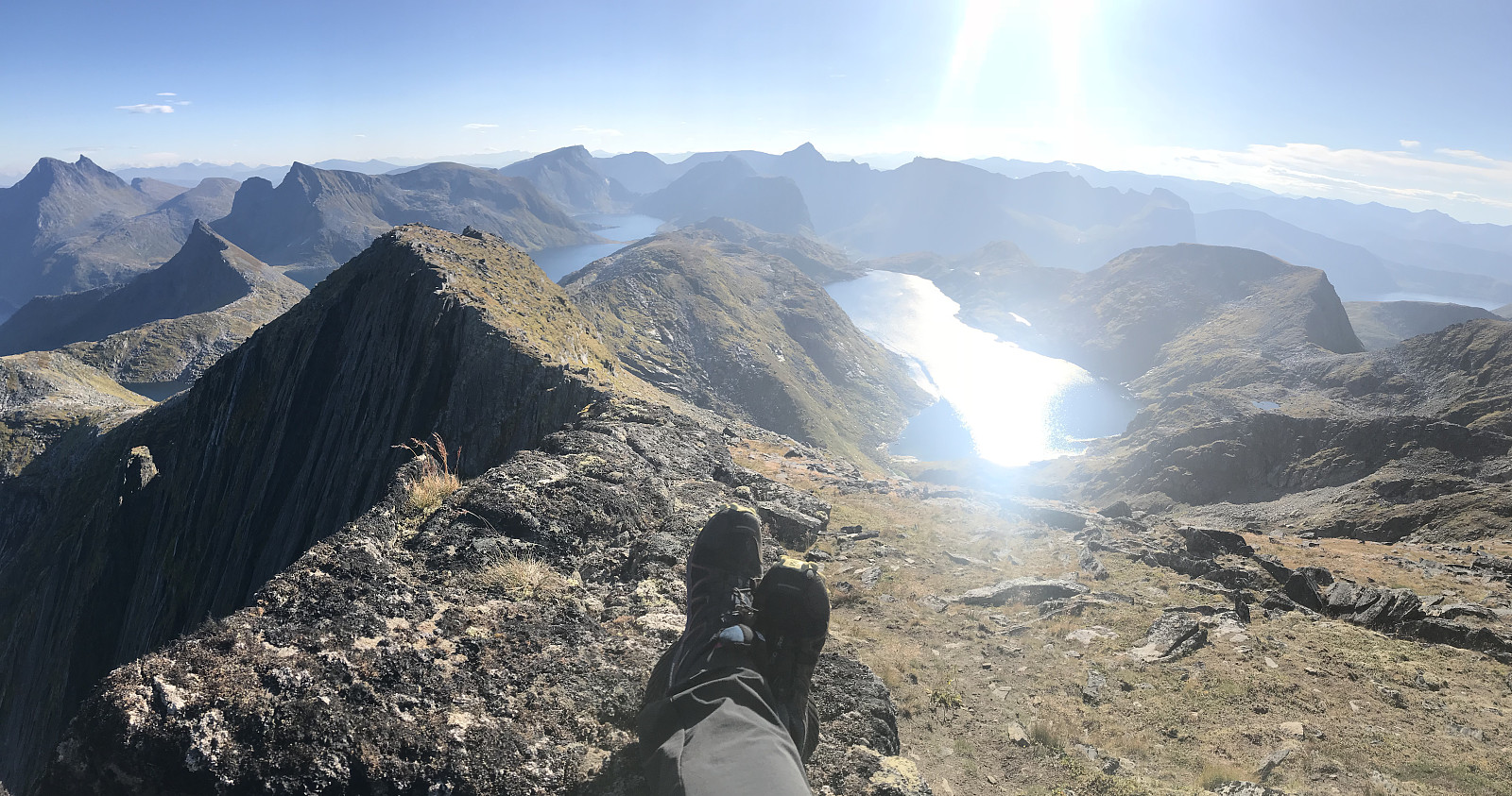 Amazing weather in Senja today meant a tough decision between Breidtinden and Roalden. Paal has already done Breidtinden and felt like trying something new so Roalden it was!
We parked by the side of the church/cemetery and followed a marked trail into the valley. A muddy start with quite a lot of swamp, the first 300m in elevation were pretty wet. But we were quickly up on a dry path and the views just got more and more breathtaking, I thought this hike was seriously stunning!!! The path was very, very well marked and easy to walk on. Vi koste oss masse :) takk for turen uglefisk (Paal Andre Lund)
Amazing weather in Senja today meant a tough decision between Breidtinden and Roalden. Paal has already done Breidtinden and felt like trying something new so Roalden it was!
We parked by the side of the church/cemetery and followed a marked trail into the valley. A muddy start with quite a lot of swamp, the first 300m in elevation were pretty wet. But we were quickly up on a dry path and the views just got more and more breathtaking, I thought this hike was seriously stunning!!! The path was very, very well marked and easy to walk on. Vi koste oss masse :) takk for turen uglefisk (Paal Andre Lund)
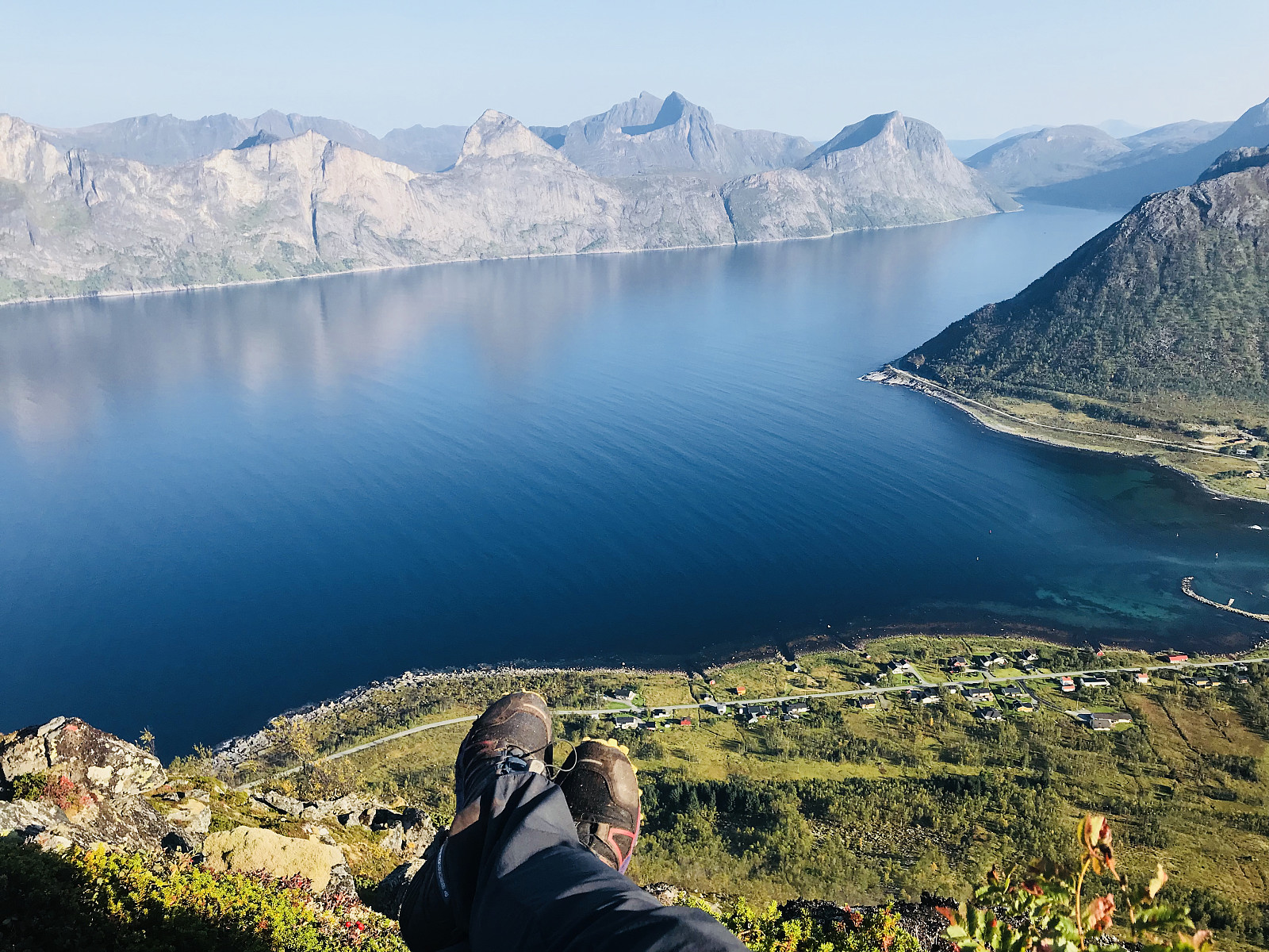
Knuten - for en camping plass!
- Dato:
- 09.09.2018
 Nordlys varsel var ganske bra i går og vi hadde lyst for å finne oss en sikkelig digg camping plass med tenker på bilder senere i natt. Fant noe nydelig gress mot toppen, dessverre var det ikke helt flat og vi sovet ikke 100%. Solnedgang, Nordlys og å stå opp i morges med kanon vær var helt utrolig!
Kyle
- Dato:
- 09.09.2018
- Turtype:
- Fottur
- Turlengde:
- 3:00t
- Distanse:
- 4,0km
 En ordentlig kose tur!
We had a few hours in the afternoon to kill and decided to take a stroll in the sunshine. We parked right between Senjahoppen and Mefjordvær and followed a marked path to the left of the road. We gained height pretty quickly and the views were absolutely stunning the whole way!! The path was great to walk on and we relaxed for about an hour in the sunshine at the top.
We don’t have any GPS tracking or information because my watch died and Paal forgot to turn his off, but we used around 45m to the top and the trail is 1.9km up.
En ordentlig kose tur!
We had a few hours in the afternoon to kill and decided to take a stroll in the sunshine. We parked right between Senjahoppen and Mefjordvær and followed a marked path to the left of the road. We gained height pretty quickly and the views were absolutely stunning the whole way!! The path was great to walk on and we relaxed for about an hour in the sunshine at the top.
We don’t have any GPS tracking or information because my watch died and Paal forgot to turn his off, but we used around 45m to the top and the trail is 1.9km up.
Store Blåmann
- Dato:
- 06.09.2018
- Turtype:
- Fjelltur
 A muddy start to the trail, but soon we hit the rocks and scrambling and my shoes dried out. Was difficult to follow the path over the rocks, so pretty often we walked off course and ended up pulling ourselves over much bigger rocks than we should have. It got easier to stay on course when we started noticing the green markers about 300m from the top (I think). Was a great, fun hike, takk for turen uglefisk (Paal Andre Lund)

