Archiv - Nach Datum
Archiv - Nach Aktivität
-
Andere Tour (1)
- Kayaking (1)
-
Andere Wintertour (4)
- Schneeschuhtour (4)
-
Fahrradtour (137)
- Fahrradtour Straße (9)
- Fahrradtour gemischt (51)
-
Fußtour (740)
- Bergtour (363)
- Jogging (18)
- Spaziergang (89)
- Wanderung (270)
-
Skitour (4)
- Tourenskilauf (4)
Archiv - Nach Geografie
Peakbookfreunde


Gesammelte Listen
-
Bergen ≥ 50m pf. og ≥ 100 m.o.h.
(87/89)
 97%
97% -
Most dominating tops of the Bergen peninsula
(68/75)
90%
-
Utvalgte topper og turmål i Bergen
(316/350)
90%
-
Alle topper i Bergen
(357/398)
89%
-
Opptur Bergen
(100/113)
88%
-
De syv fjell rundt Bergen
(6/7)
85%
-
Sund ≥ 50m pf.
(14/18)
77%
-
Os ≥ 50m pf.
(25/34)
73%
-
Søyler (fastmerker) i Bergen
(68/100)
68%
-
Fjell ≥ 50m pf.
(21/32)
65%

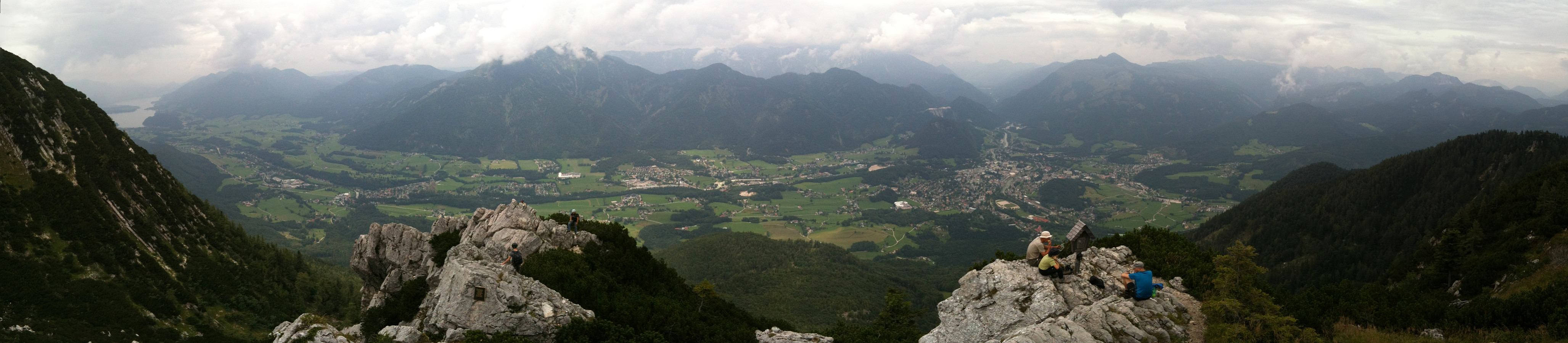
Schober & Frauenkopf
- Datum:
- 09.07.2015
- Tourcharakter:
- Bergtour
- Tourlänge:
- 1:45h
- Entfernung:
- 3,6km
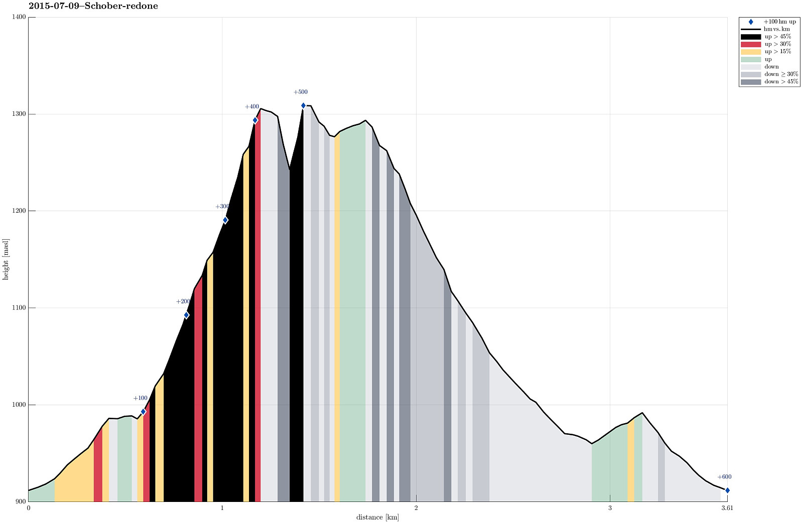 We parked right next to Forsthaus Wartenfels and ascended to the ruin Wartenfels that towers above the Forsthaus (only a few minutes up). From there, it is a quick ascent up to Schober, from where one enjoyes exceptional views in all directions. The matter of fact that Schober is kind of the northernmost (somehow) higher mountain frees extended views in many directions! From there, we connected to Frauenkopf, which is only a few steps away from Schober. From there, one gets back to Forsthaus Wartenfels via a good-to-walk path, mostly through the forest underneath Schober. In total, this hike is short and rewarding. At a few places, there are steel ropes that help to ascend/descend and at some very few places you have to watch you step, when getting up, down, or around. With a little >>>
Grosser & Kleiner Sonnstein
- Datum:
- 06.07.2015
- Tourcharakter:
- Bergtour
- Tourlänge:
- 3:00h
- Entfernung:
- 5,5km
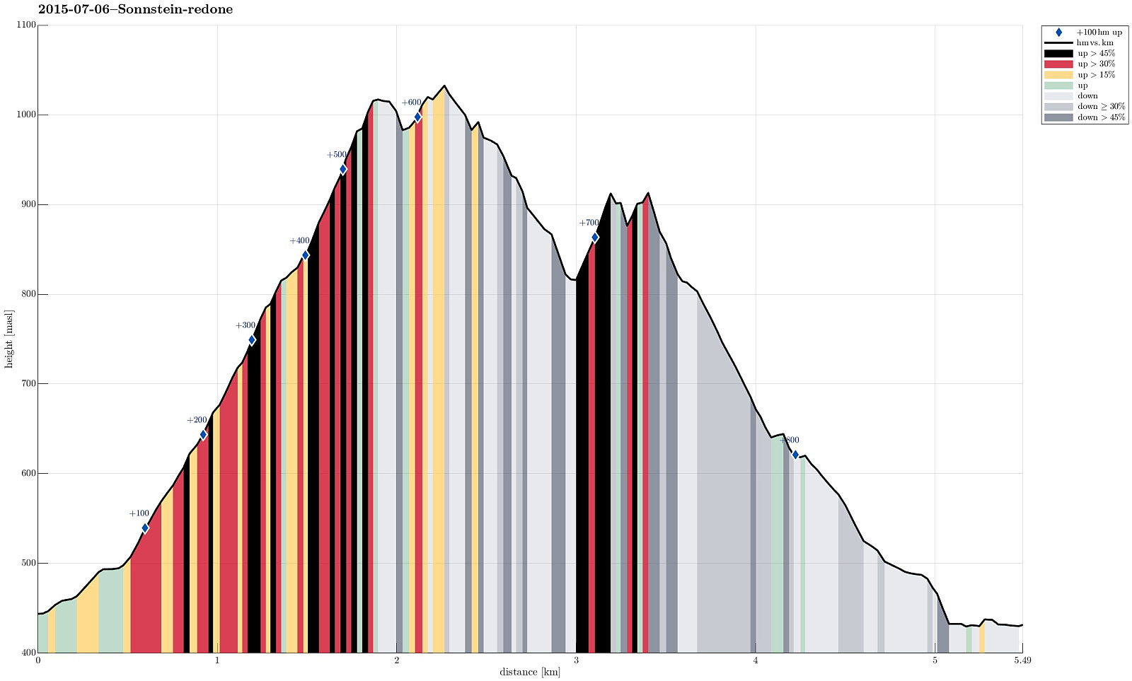 We started with two cars, leaving one a small parking spot south of Traunkirchen (if you drive from north, for ex., Gmunden, in the driection of Bad Ischl, then you first cut short Traunkirchen through a tunnel -- shortly afterwards you pass through a very short new tunnel and then the parking spot is on the right). Then we drove further, with the other car, towards Ebensee. As soon as we entered Ebensee, even before crossing the Traun, we turned right at the first opportunity (onto Hauptstrasse). After only a short distance -- basically at the first regular option to turn right, again -- we turned right (onto Langbarthstrasse). From there, we turn right again, into Kirchengasse -- this turn is not obvious (the turn is very sharp and Kirchengasse is very narrow). Right next to the church >>>
Traunstein
- Datum:
- 08.08.2014
- Tourcharakter:
- Bergtour
- Tourlänge:
- 6:00h
- Entfernung:
- 14,5km
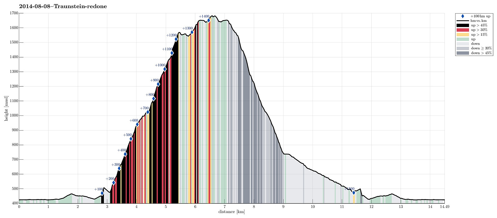 Starting from Traunsee (~450m, southeast from Gmunden), up the Naturfreundesteig (climbing trail, category A/B), we first reached Traunsteinhaus (1575m, still quite new after a recent upgrading). It took a bit more than 2 hours, but easily this could be more, depending on the climbing conditions -- it's more than 1000m up a substantially steep climbing path! Then, we connected to Gmundner Hütte (1660m), another impressive house on top of this prominent mountain! The actual top, Traunstein (1691m) is then quite near and easy to reach. Down we took the trail towards Mair Alm, which is very steep, but good to go. All in all, including an extended break on Gmundner Hütte, this was about 6+ hours of hiking. Very rewarding!
Selected photos are available as Google photo album .
Starting from Traunsee (~450m, southeast from Gmunden), up the Naturfreundesteig (climbing trail, category A/B), we first reached Traunsteinhaus (1575m, still quite new after a recent upgrading). It took a bit more than 2 hours, but easily this could be more, depending on the climbing conditions -- it's more than 1000m up a substantially steep climbing path! Then, we connected to Gmundner Hütte (1660m), another impressive house on top of this prominent mountain! The actual top, Traunstein (1691m) is then quite near and easy to reach. Down we took the trail towards Mair Alm, which is very steep, but good to go. All in all, including an extended break on Gmundner Hütte, this was about 6+ hours of hiking. Very rewarding!
Selected photos are available as Google photo album .
Katrin
- Datum:
- 07.08.2014
- Tourcharakter:
- Bergtour
- Tourlänge:
- 3:00h
- Entfernung:
- 6,6km
 Up from Bad Ischl (where the cable car starts, at 470m, via Bildweg) to Katrinalm (1413m), which is a nice, steep hike up (about 1000m up) and then -- after some nice rest with served food and drinks -- quickly up to Katrin-Kreuz (1542m) and Elferkogel (1601m). Down, then, very comfortably with the cable car. :-)
Hochleckenhaus (Höllengebirge)
- Datum:
- 06.08.2014
- Tourcharakter:
- Bergtour
- Tourlänge:
- 4:00h
- Entfernung:
- 12,1km
 Starting from Taferlklaussee (763m), we first ascended to Hochleckenhaus (1574m) via a well-marked path (note: the start is somehow unclear -- mostly due to many other small trails near and around Taferlklausssee). After a nice and refreshing rest at Hochleckenhaus -- yes, with served food and drinks! :-) -- we descended towards Steinbach am Attersee (via Geissalm and Stieg -- the 2nd option for hiking to Steinbach), which offers terrific views -- not at the least to Attersee! The path down from Höllengebirge is (partially) steep and it's hundreds of meters straight down next to the path in selected places (you better are not afraid of heights there). All in all, a great hike! :-)
Selected photos are available as a Google photo album .
Starting from Taferlklaussee (763m), we first ascended to Hochleckenhaus (1574m) via a well-marked path (note: the start is somehow unclear -- mostly due to many other small trails near and around Taferlklausssee). After a nice and refreshing rest at Hochleckenhaus -- yes, with served food and drinks! :-) -- we descended towards Steinbach am Attersee (via Geissalm and Stieg -- the 2nd option for hiking to Steinbach), which offers terrific views -- not at the least to Attersee! The path down from Höllengebirge is (partially) steep and it's hundreds of meters straight down next to the path in selected places (you better are not afraid of heights there). All in all, a great hike! :-)
Selected photos are available as a Google photo album .
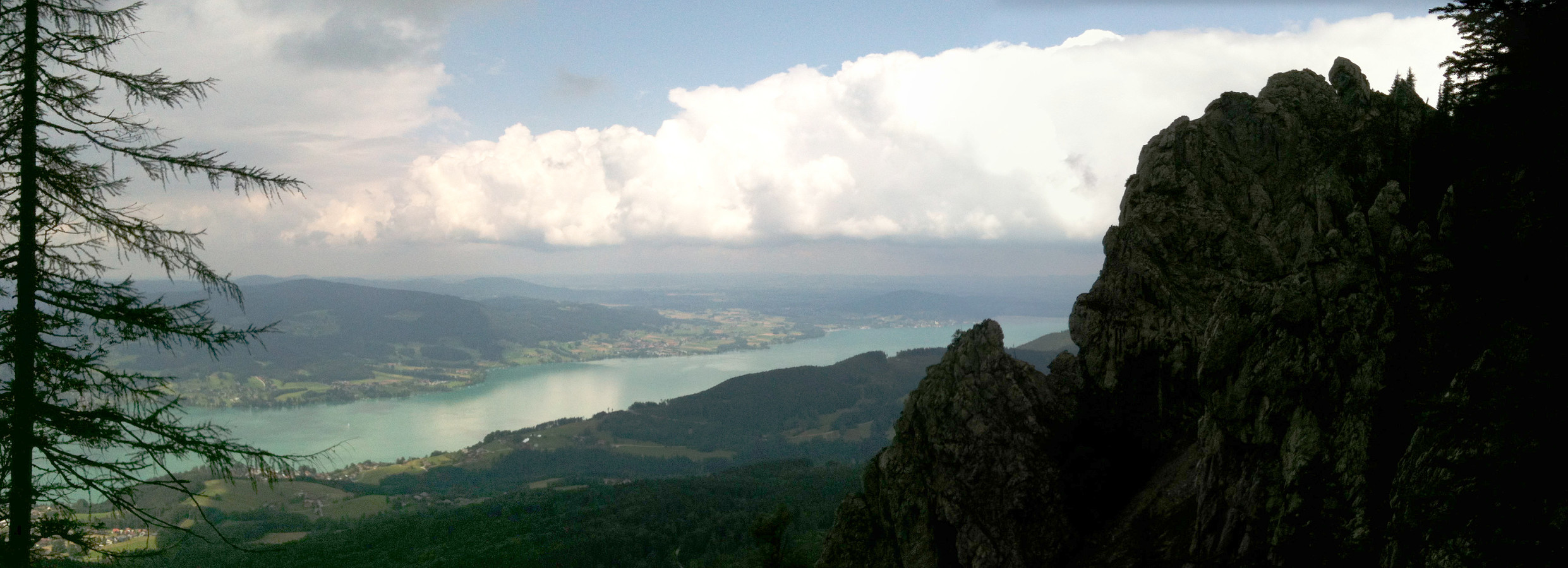
From Schafberg down to St. Wolfgang
- Datum:
- 06.07.2005
- Tourcharakter:
- Wanderung
- Tourlänge:
- 6:00h
- Entfernung:
- 10,5km
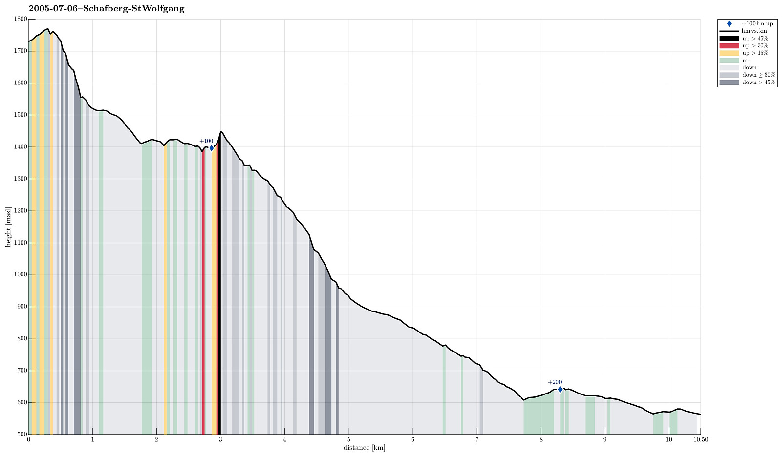 We first took the mountain rail up to the top of Schafberg with the plan to walk down from there to St. Wolfgang. From the top, we then descended first towards the nearby Himmelspforte (in northwestern direction). There, we then started the real descent, which indeed is quite steep on the northern side of Schafberg, at least in the beginning. We followed the Himmelspfortenweg downwards, passing by Suissensee, and rounding another ridge to get to Mittersee, a nice little lake underneath the majestic Schafberg. From there, we continued further along this path, getting very close to Mönichsee, before we eventually got (back) to the southwestern side of Schafberg, heading down towards St. Wolfgang. We quickly arrived at the Auerriesenweg, which we then followed down until we basically were >>>
