Archive - Date
Archive - Activity
-
Bike trip (137)
- Bike trip - mixed (51)
- Bike trip - road (9)
-
Other trip (1)
- Kayaking (1)
-
Other winter trip (4)
- Snowshoe trip (4)
- Ski trip (4)
- Trip by foot (740)
Archive - Geography
Peakbook-Friends


Collected lists
-
Bergen ≥ 50m pf. og ≥ 100 m.o.h.
(87/89)
 97%
97% -
Most dominating tops of the Bergen peninsula
(68/75)
90%
-
Utvalgte topper og turmål i Bergen
(316/350)
90%
-
Alle topper i Bergen
(357/398)
89%
-
Opptur Bergen
(100/113)
88%
-
De syv fjell rundt Bergen
(6/7)
85%
-
Sund ≥ 50m pf.
(14/18)
77%
-
Os ≥ 50m pf.
(25/34)
73%
-
Søyler (fastmerker) i Bergen
(68/100)
68%
-
Fjell ≥ 50m pf.
(21/32)
65%

Jurefethaugen and Vikåsen
- Date:
- 27.10.2024
- Characteristic:
- Hike
- Duration:
- 2:00h
- Distance:
- 4.9km
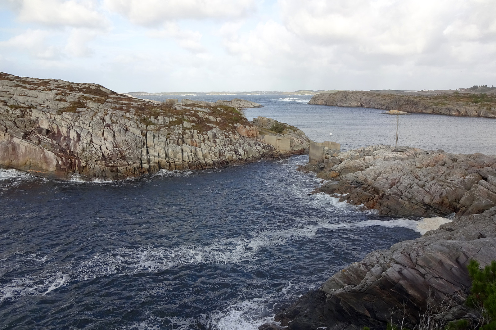 The main idea was to use a window between some predicted rain showers and to go and have a look at the place, where some 40 years ago two wave power stations were built at Kalvøyna in Øygarden. To make this at least somewhat a hike, also, we parked near Balsvågen right next to Turøyvegen. From there, our first goal was to step up to Jurefethaugen (or Gjugrefethaugen or ...). This worked out without difficulties (we only needed to walk around a rather wet spot between the street and the hill). Close to the top, we passed a really impressive stone wall. From Jurefethaugen, we aimed at Lykleneset a bit further north. The idea was to see if we could make it there via the wild west-side of this peninsula. This worked well, but it should be noted that progress is not necessarily possible >>>
Langaneset from Vadmyra
- Date:
- 26.10.2024
- Characteristic:
- Hike
- Duration:
- 2:00h
- Distance:
- 5.4km
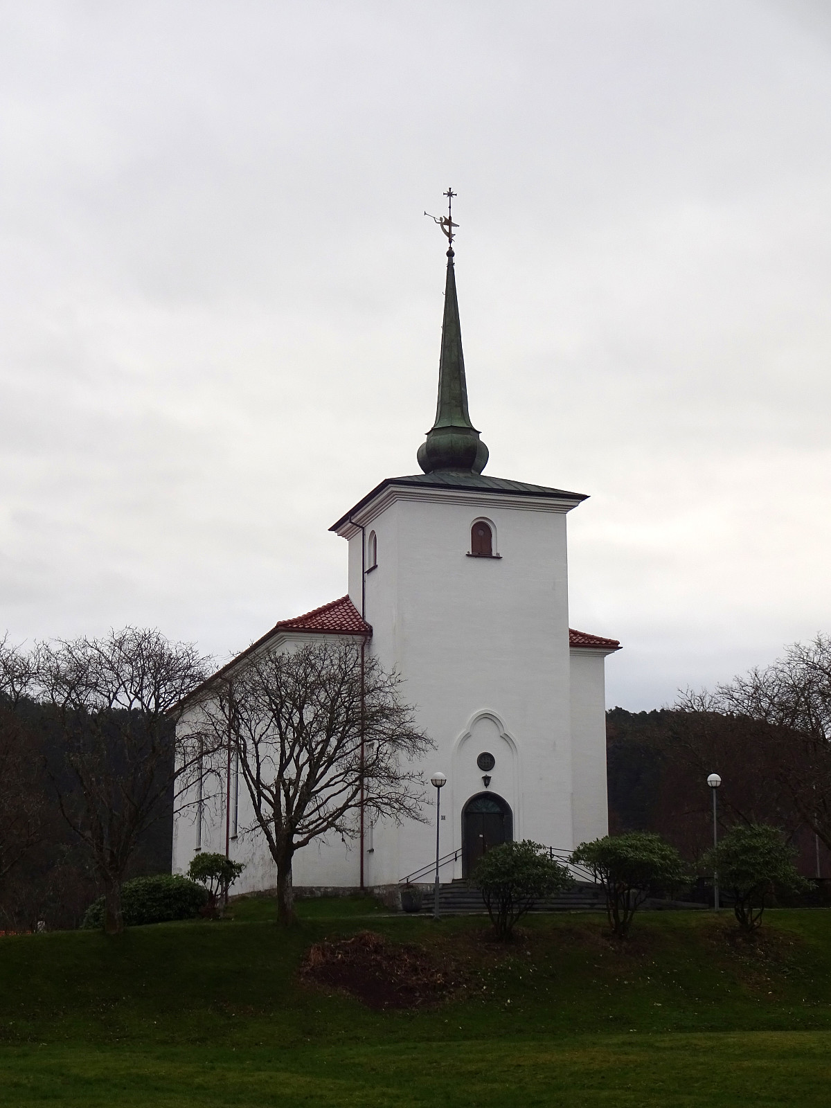 Not much to write. Stretching my legs a little, taking a look at Loddefjord kirke (and also at Frasmers Møllestein). Then exploring Langaneset in Storavatnet. More rain was expected, but we take it with less, also, I think! :-)
Selected photos are available as Google photo album .
See also the related FB-page Hiking around Bergen, Norway .
Not much to write. Stretching my legs a little, taking a look at Loddefjord kirke (and also at Frasmers Møllestein). Then exploring Langaneset in Storavatnet. More rain was expected, but we take it with less, also, I think! :-)
Selected photos are available as Google photo album .
See also the related FB-page Hiking around Bergen, Norway .
Storenuvarden and more
- Date:
- 19.10.2024
- Characteristic:
- Bike trip - mixed
- Duration:
- 6:30h
- Distance:
- 70.6km
 Given the nice autumn weather, I made a plan to cycle around Vidden and explore some minor hills along the way. I started by cycling around Nordåsvatnet (in its north), continuing to Paradis. From there, I took the road through Sanddalen to get to the main axis towards Arna from Nesttun. It started in Sanddalen that I understood that this trip will be special, given a chain that had become quite slippery, already -- the relatively steep part upwards on Sandbrekkevegen I already had to push the bike... My first exploration goal of the day was to bike out Hardangervegen right next to the train tracks on the other, southeastern side of Midtunelva. This works, but the path (or better "path") is not really prepared and biking there with a street bike, for example, is not reasonable. >>>
Bike-hiking hills near Drotningsvik
- Date:
- 06.10.2024
- Characteristic:
- Bike trip - mixed
- Duration:
- 4:00h
- Distance:
- 32.9km
 Given the medium-nice weather -- certainly good enough, though! -- I decided to make another bike-hiking trip: this time into the direction of Drotningsvik, where I knew of a couple of hills that I had not visited so far. I started by cycling into the direction of Olsvik, passing by Loddefjord on my way. In the northwest of Harafjellet, I then left my bike behind for the first time, making my way up to Storhaugen. Given the houses that have been built right up to the "top" of Storhaugen, one does not really get any nature feeling up there. The views, however, are quite fine. Next, I aimed at Godvikaskjenet, approaching it from the northeast. Godvikveien leads up there quite steeply and I left my bike behind "half way up" that road. Once closer to the "top", >>>
Short round at Varden
- Date:
- 05.10.2024
- Characteristic:
- Walk
- Duration:
- 0:45h
- Distance:
- 2.4km
 Despite the rain, some fresh air was needed, and thus I made a short round at Varden. Good to get out for a short while! :-)
See also the related FB-page Hiking around Bergen, Norway .
Despite the rain, some fresh air was needed, and thus I made a short round at Varden. Good to get out for a short while! :-)
See also the related FB-page Hiking around Bergen, Norway .
Knappen
- Date:
- 29.09.2024
- Characteristic:
- Walk
- Duration:
- 0:45h
- Distance:
- 4.7km
 Instead of doing something larger and longer, we "ended up" making a short excursion to Knappen, only. Short, but nice! :-)
See also the related FB-page Hiking around Bergen, Norway .
Petter Bjørstad has a useful page about Knappen .
Web page UT.no from the Norwegian Trekking Association recommends another hike to Knappen .
Instead of doing something larger and longer, we "ended up" making a short excursion to Knappen, only. Short, but nice! :-)
See also the related FB-page Hiking around Bergen, Norway .
Petter Bjørstad has a useful page about Knappen .
Web page UT.no from the Norwegian Trekking Association recommends another hike to Knappen .
Bike-hiking Landåsfjellet and more
- Date:
- 01.09.2024
- Characteristic:
- Bike trip - mixed
- Duration:
- 4:00h
- Distance:
- 37.5km
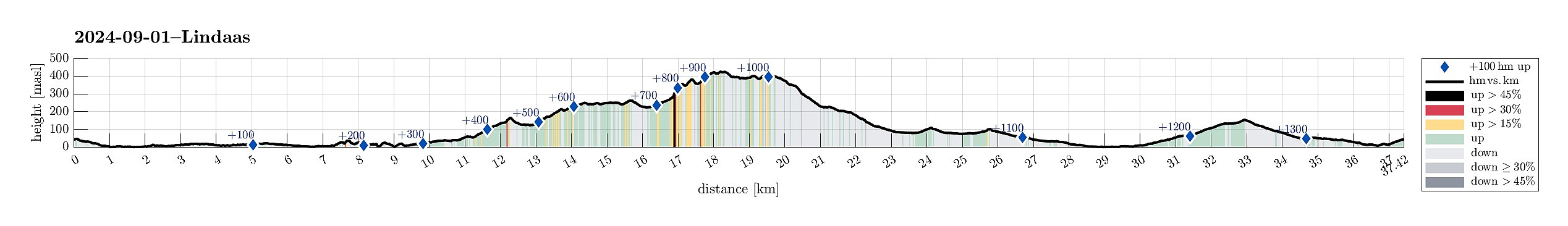 Somehow, I thought that this Sunday was the day for visiting Nattlandsfjellet and checking out the view-point right above the tunnel of Nye Sædalsveien. I got onto my eBike and biked around the south of Bønes, following the north shore of Nordåsvatnet. This brought me to Gamlehaugen, where I decided to interrupt my bike-trip for a short exploration of the area around the King's house. My first goal there was to get up to the small hill in the southeast of the mansion. I first thought that there would be a way to get there "directly", just to find that this little hill has some rather steep cliff on its west-side -- not high, but high enough to be an obstacle. Walking around, however, brought me to a path that -- while apparently not much used -- lead me easily and conveniently >>>
Bike-hiking Milde and Hordnesskogen
- Date:
- 31.08.2024
- Characteristic:
- Bike trip - mixed
- Duration:
- 5:00h
- Distance:
- 48.6km
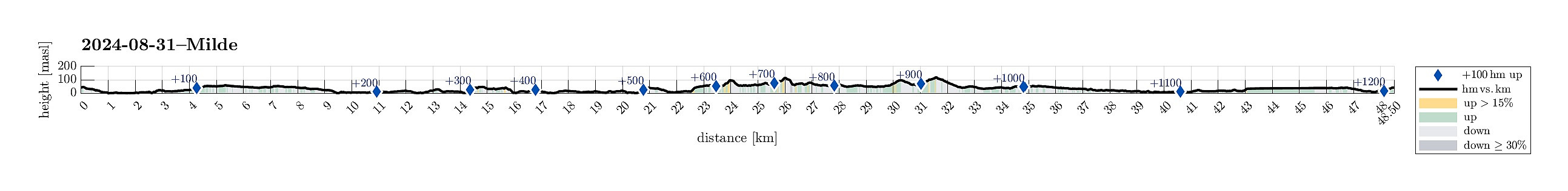 With a nice Saturday at my hand (and foot), I decided to explore the southwest of Milde. I thus mounted my eBike and cycled southwards, passing by Straume and biking along Ytrebygdsvegen, then continuing into the direction of Hjellestad/Milde. While biking by the Arboretet at Milde, one of the spokes on one wheel snapped -- not good. I still continued further southwards, aiming at Skipanesvegen in the south of Mildevatnet. Near Steingardsvikane, I left my bike behind and continued to do a short hike. I first walked along a trail that leads over to Okshammarsvika from Steingardsvikane. At the first nice bay, north of Steingardsvikane, I then found a trail that suggested to bring me up to Slettåsen. While this trail was easy to follow, first, it became less clear near the "top" >>>
Evening Ormhelleren
- Date:
- 28.08.2024
- Characteristic:
- Walk
- Duration:
- 1:30h
- Distance:
- 2.5km
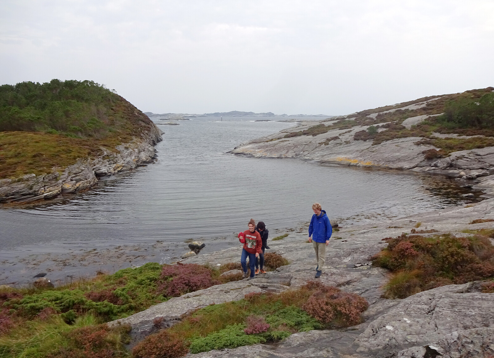 Given a likely rain-free evening, we headed out to Ormhelleren in the south of Rongøyna in Øygarden. We first explored the area around Hesthaugen before then testing the waters in the bay southeast of Hesthaugen. On the way back, an attempt to cross over Rongaloftet failed due to a lack of time, the trail leading towards the east (instead of the north), and the absence of a willingness for some evening bush war...
Selected photos are available as Google photo album .
See also the related FB-page Hiking around Bergen, Norway .
Given a likely rain-free evening, we headed out to Ormhelleren in the south of Rongøyna in Øygarden. We first explored the area around Hesthaugen before then testing the waters in the bay southeast of Hesthaugen. On the way back, an attempt to cross over Rongaloftet failed due to a lack of time, the trail leading towards the east (instead of the north), and the absence of a willingness for some evening bush war...
Selected photos are available as Google photo album .
See also the related FB-page Hiking around Bergen, Norway .
Wet Arboretet
- Date:
- 24.08.2024
- Characteristic:
- Walk
- Duration:
- 3:00h
- Distance:
- 3.7km
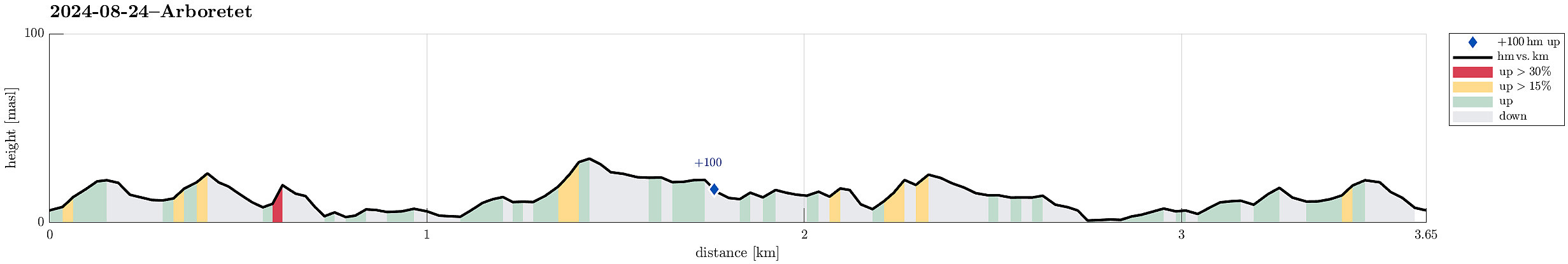 Despite the rather wet weather forecast, we still embarked on a visit to Arboretet in Milde. It was nice (and [very] wet). :-)
Selected photos are available as Google photo album .
See also the related FB-page Hiking around Bergen, Norway .
Despite the rather wet weather forecast, we still embarked on a visit to Arboretet in Milde. It was nice (and [very] wet). :-)
Selected photos are available as Google photo album .
See also the related FB-page Hiking around Bergen, Norway .
