Archive - Date
Archive - Activity
-
Bike trip (137)
- Bike trip - mixed (51)
- Bike trip - road (9)
-
Other trip (1)
- Kayaking (1)
-
Other winter trip (4)
- Snowshoe trip (4)
- Ski trip (4)
- Trip by foot (740)
Archive - Geography
Peakbook-Friends


Collected lists
-
Bergen ≥ 50m pf. og ≥ 100 m.o.h.
(87/89)
 97%
97% -
Most dominating tops of the Bergen peninsula
(68/75)
90%
-
Utvalgte topper og turmål i Bergen
(316/350)
90%
-
Alle topper i Bergen
(357/398)
89%
-
Opptur Bergen
(100/113)
88%
-
De syv fjell rundt Bergen
(6/7)
85%
-
Sund ≥ 50m pf.
(14/18)
77%
-
Os ≥ 50m pf.
(25/34)
73%
-
Søyler (fastmerker) i Bergen
(68/100)
68%
-
Fjell ≥ 50m pf.
(21/32)
65%

Schober & Frauenkopf
- Date:
- 09.07.2015
- Characteristic:
- Hillwalk
- Duration:
- 1:45h
- Distance:
- 3.6km
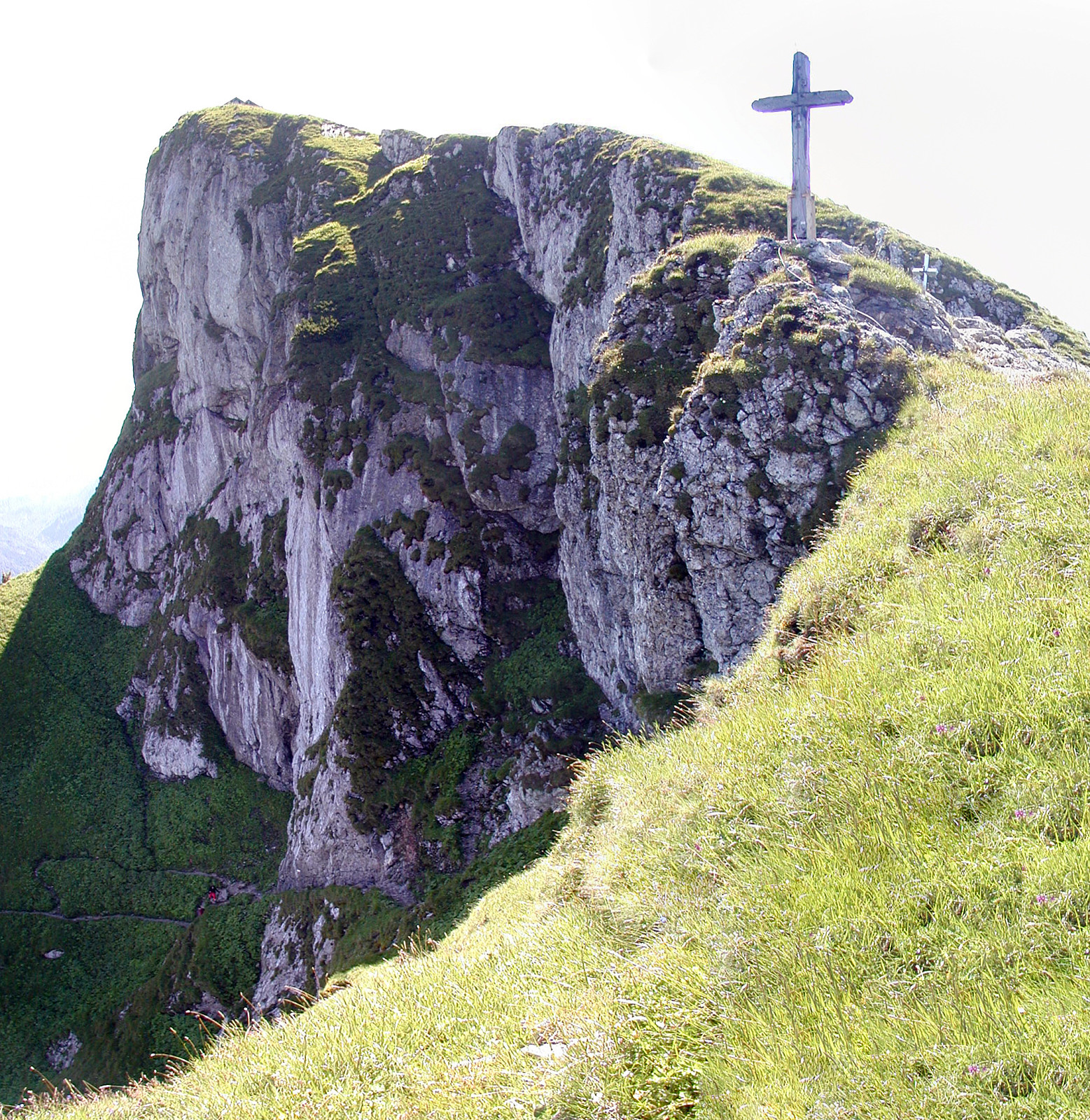
 We parked right next to Forsthaus Wartenfels and ascended to the ruin Wartenfels that towers above the Forsthaus (only a few minutes up). From there, it is a quick ascent up to Schober, from where one enjoyes exceptional views in all directions. The matter of fact that Schober is kind of the northernmost (somehow) higher mountain frees extended views in many directions! From there, we connected to Frauenkopf, which is only a few steps away from Schober. From there, one gets back to Forsthaus Wartenfels via a good-to-walk path, mostly through the forest underneath Schober. In total, this hike is short and rewarding. At a few places, there are steel ropes that help to ascend/descend and at some very few places you have to watch you step, when getting up, down, or around. With a little >>>
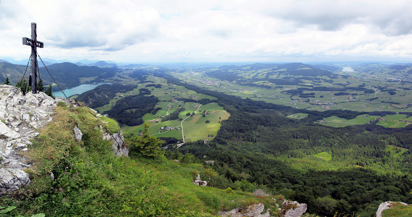
Katrin
- Date:
- 07.08.2014
- Characteristic:
- Hillwalk
- Duration:
- 3:00h
- Distance:
- 6.6km
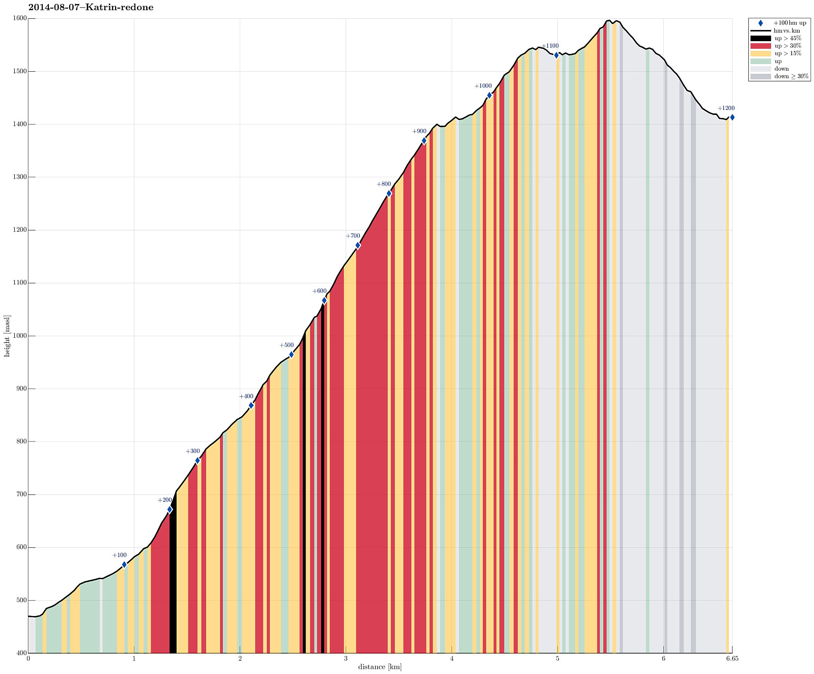 Up from Bad Ischl (where the cable car starts, at 470m, via Bildweg) to Katrinalm (1413m), which is a nice, steep hike up (about 1000m up) and then -- after some nice rest with served food and drinks -- quickly up to Katrin-Kreuz (1542m) and Elferkogel (1601m). Down, then, very comfortably with the cable car. :-)
From Schafberg down to St. Wolfgang
- Date:
- 06.07.2005
- Characteristic:
- Hike
- Duration:
- 6:00h
- Distance:
- 10.5km
 We first took the mountain rail up to the top of Schafberg with the plan to walk down from there to St. Wolfgang. From the top, we then descended first towards the nearby Himmelspforte (in northwestern direction). There, we then started the real descent, which indeed is quite steep on the northern side of Schafberg, at least in the beginning. We followed the Himmelspfortenweg downwards, passing by Suissensee, and rounding another ridge to get to Mittersee, a nice little lake underneath the majestic Schafberg. From there, we continued further along this path, getting very close to Mönichsee, before we eventually got (back) to the southwestern side of Schafberg, heading down towards St. Wolfgang. We quickly arrived at the Auerriesenweg, which we then followed down until we basically were >>>
Biking across the Alps 2.4: Taxenbach-Salzburg
- Date:
- 15.08.1997
- Characteristic:
- Bike trip
- Duration:
- 9:00h
- Distance:
- 97.3km
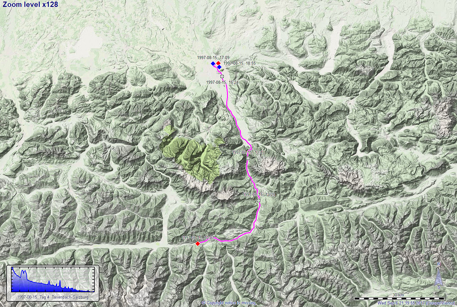 The fourth and last day of this multi-day bike trip across the Alps should bring us to Salzburg, where we had planned to take the train back to Wien. All in all, this was then more like a transport stretch at the end of this trip, even though we came by majestic mountain scenes also on this day (seen from the bottom of the valley, though). Following the Salzach, basically, we first headed eastwards, before turning more and more northwards, into the direction of Salzburg. After about 100km of cycling (and about 8 hours), we arrived in Salzburg, concluding this bike-trip across the Alps in a very satisfied mood!
More details about the entire bike-trip are available via a separate web page .
Route details about four longer bike rides in/near the Alps are summarized on a separate web page .
See also the related FB-page Hiking around Bergen, Norway .
The fourth and last day of this multi-day bike trip across the Alps should bring us to Salzburg, where we had planned to take the train back to Wien. All in all, this was then more like a transport stretch at the end of this trip, even though we came by majestic mountain scenes also on this day (seen from the bottom of the valley, though). Following the Salzach, basically, we first headed eastwards, before turning more and more northwards, into the direction of Salzburg. After about 100km of cycling (and about 8 hours), we arrived in Salzburg, concluding this bike-trip across the Alps in a very satisfied mood!
More details about the entire bike-trip are available via a separate web page .
Route details about four longer bike rides in/near the Alps are summarized on a separate web page .
See also the related FB-page Hiking around Bergen, Norway .
Biking across the Alps 2.3: Döllach-Taxenbach
- Date:
- 14.08.1997
- Characteristic:
- Bike trip
- Duration:
- 11:30h
- Distance:
- 68.3km
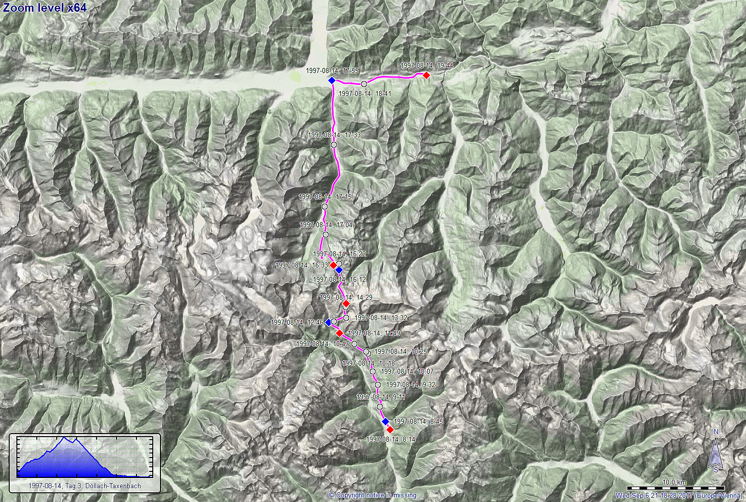 The third day of this multi-day bike trip across the Alps should be our big day, cycling the Glockner Hochalpenstrasse up to about 2500mosl! We started from Döllach and decided to take the Apriacher Höhenstrasse (on the eastern side of the valley and quite high up as compared to the lowest points in the valley, even though this meant to cut short a stretch through Heiligenblut, almost a must-see on this trip. Cycling high above the deep Möll-valley, however, provided us with great views already early in the morning and we enjoyed it already then very much! :-) After about 12km of cycling (and about +500hm up), we connected back to the main street, there coming up from Heiligenblut lying further west and down in the valley. With this, we were on this magnificent mountain road, the Glockner >>>
Biking from Salzburg to Wien 1: Salzburg-Steinbach
- Date:
- 12.08.1996
- Characteristic:
- Bike trip
- Duration:
- 6:00h
- Distance:
- 101.6km
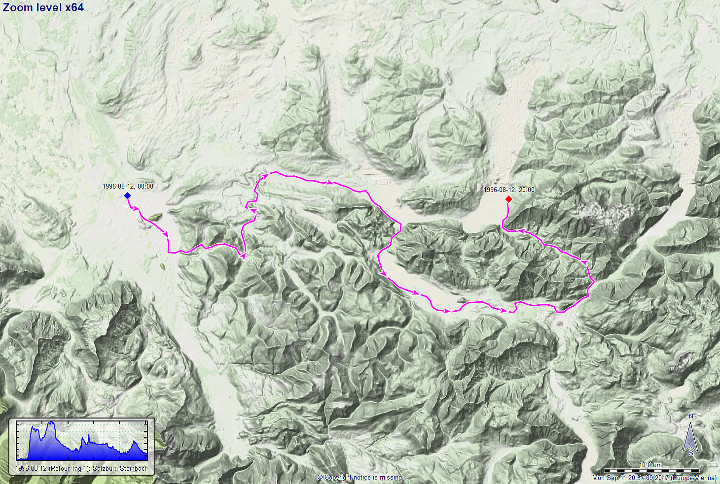 After some nice time in Salzburg, I then started my bike-trip home (from Salzburg to Wien). On the first day, I "just" made it to Attersee, but enjoyed a few extra-turns to see some more places in the particularly nice Salzkammergut, east of Salzburg. After about 115km of cycling, I then came to Steinbach am Attersee, where I stayed for two more days to enjoy the lake and its surrounding a bit further.
More details about the entire bike-trip are available via a separate web page .
Route details about four longer bike rides in/near the Alps are summarized on a separate web page .
See also the related FB-page Hiking around Bergen, Norway .
After some nice time in Salzburg, I then started my bike-trip home (from Salzburg to Wien). On the first day, I "just" made it to Attersee, but enjoyed a few extra-turns to see some more places in the particularly nice Salzkammergut, east of Salzburg. After about 115km of cycling, I then came to Steinbach am Attersee, where I stayed for two more days to enjoy the lake and its surrounding a bit further.
More details about the entire bike-trip are available via a separate web page .
Route details about four longer bike rides in/near the Alps are summarized on a separate web page .
See also the related FB-page Hiking around Bergen, Norway .
Biking across the Alps 1.2: Winkl-Krakaudorf
- Date:
- 03.08.1995
- Characteristic:
- Bike trip
- Duration:
- 13:15h
- Distance:
- 90.2km
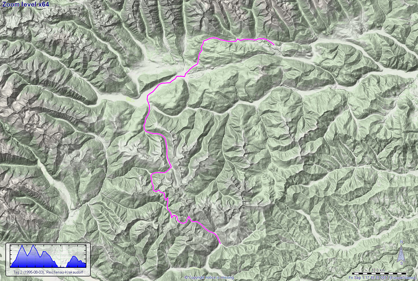 We started day 2 of this biking tour across the alps in Winkl near Ebene Reichenau with the goal to traverse the Nockberge first. We thus started on the Nockalmstrasse along the Stangenbach, heading for our first major pass on this tour, Schiesstlscharte (2025mosl). About two hours after starting our day, we eventually arrived at the pass, truly happy in all regards (beautiful nature, great views, and arriving at the pass after a strenuous ride). The next goal was then another nice pass in the Nockberge, not far from Schiesstlscharte, but with a significant "dive" into the Loebengraben in between (500 height meters down and then up again). After another two hours, we then arrived at this other pass, Steigerhöhe, at 2030mosl. All in all, we enjoyed the Nockberge a great lot, >>>
