Arkiv - dato
Arkiv - aktivitet
-
Annen tur (1)
- Kajakkpadling (1)
-
Annen vintertur (4)
- Trugetur (4)
- Fottur (740)
-
Skitur (4)
- Fjellskitur (4)
-
Sykkeltur (137)
- Blandet sykling (51)
- Gatesykling (9)
Arkiv - Etter geografi
"Peakbookvenner"


Lister jeg samler etter
-
Bergen ≥ 50m pf. og ≥ 100 m.o.h.
(87/89)
 97%
97% -
Most dominating tops of the Bergen peninsula
(68/75)
90%
-
Utvalgte topper og turmål i Bergen
(316/350)
90%
-
Alle topper i Bergen
(357/398)
89%
-
Opptur Bergen
(100/113)
88%
-
De syv fjell rundt Bergen
(6/7)
85%
-
Sund ≥ 50m pf.
(14/18)
77%
-
Os ≥ 50m pf.
(25/34)
73%
-
Søyler (fastmerker) i Bergen
(68/100)
68%
-
Fjell ≥ 50m pf.
(21/32)
65%

Großglockner from Ködnitztal
- Dato:
- 17.07.2016
- Turtype:
- Fjelltur
- Turlengde:
- 12:00t
- Distanse:
- 15,7km
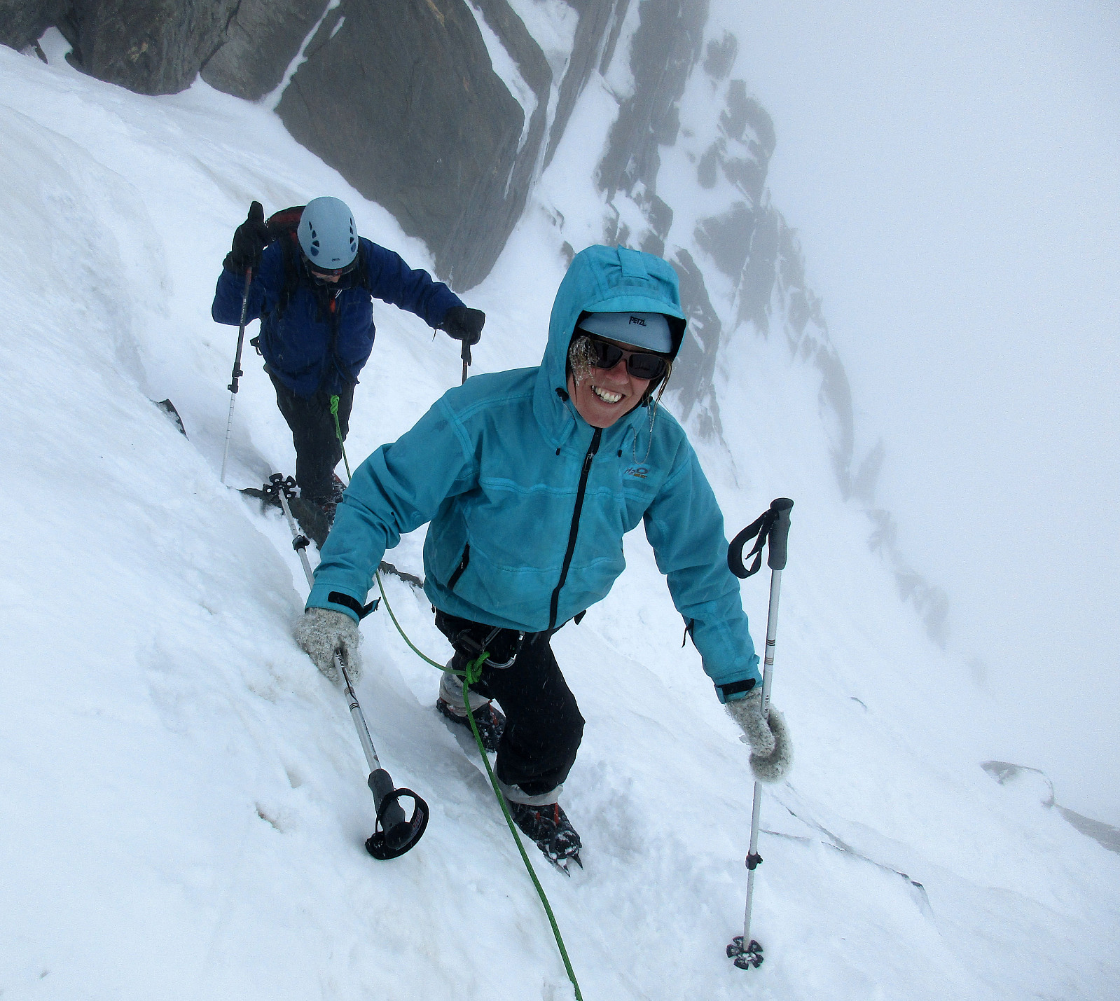 We started from Lucknerhaus, where a nice guy drove us up to Lucknerhuette (in order to give us an easy start into this hike)! From Lucknerhuette, we did a relaxed walk up to the Fanatscharte (and Stuedlhuette, there). On Stuedlhuette, we met our guide (from the Kalser Bergfuehrer) and discussed the weather (it really did not look promising, both in terms of rain/snow and also wind). After some thinking, we decided to still make an attempt, at least up to Adlersruhe (and Erzherzog-Johann-Huette, there). We started (into the freezing rain) and followed the "Normalweg", which leads around Schere, first, before then ascending on the upper-left side of Koednitzkees, before crossing over (to the east), leaving the glacier there, and continuing as a moderately easy climibing stretch >>>
Biking across the Alps 2.3: Döllach-Taxenbach
- Dato:
- 14.08.1997
- Turtype:
- Sykkeltur
- Turlengde:
- 11:30t
- Distanse:
- 68,3km
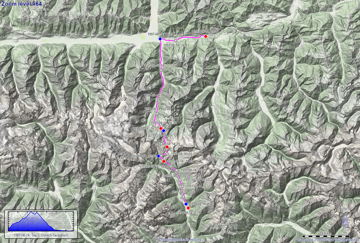 The third day of this multi-day bike trip across the Alps should be our big day, cycling the Glockner Hochalpenstrasse up to about 2500mosl! We started from Döllach and decided to take the Apriacher Höhenstrasse (on the eastern side of the valley and quite high up as compared to the lowest points in the valley, even though this meant to cut short a stretch through Heiligenblut, almost a must-see on this trip. Cycling high above the deep Möll-valley, however, provided us with great views already early in the morning and we enjoyed it already then very much! :-) After about 12km of cycling (and about +500hm up), we connected back to the main street, there coming up from Heiligenblut lying further west and down in the valley. With this, we were on this magnificent mountain road, the Glockner >>>
Biking across the Alps 2.2: Hermagor-Döllach
- Dato:
- 13.08.1997
- Turtype:
- Sykkeltur
- Turlengde:
- 10:00t
- Distanse:
- 94,3km
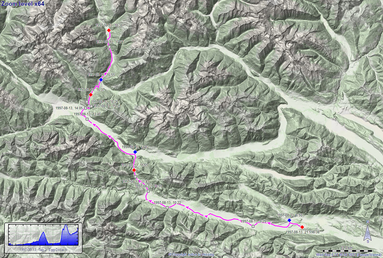 The second day of this multi-day bike trip across the Alps brought us close to the big goal, the Glockner Hochalpenstrasse. First, however, we continued through the Gail-valley for about 40km until we came to Kötschach-Mauthen, where the valley stops to be wide and comparably flat. This was the point, where we wanted to cross over to the Drau-valley (in the north of the Gail-valley). Thus, we traversed the Gailbergsattel, i.e., the first major pass on this trip (almost 1000mosl). Once in the Drau-valley, we continued in western (northwestern) direction, getting closer to Lienz quickly. Before actually getting to Lienz, however, we made a turn to the north, leaving the Drau-valley again and crossing over the second major pass on this day, i.e., Iselsberg (about 1200mosl), to the Möll-valley. >>>
Biking across the Alps 2.1: Villach-Hermagor
- Dato:
- 12.08.1997
- Turtype:
- Sykkeltur
- Turlengde:
- 3:15t
- Distanse:
- 50,7km
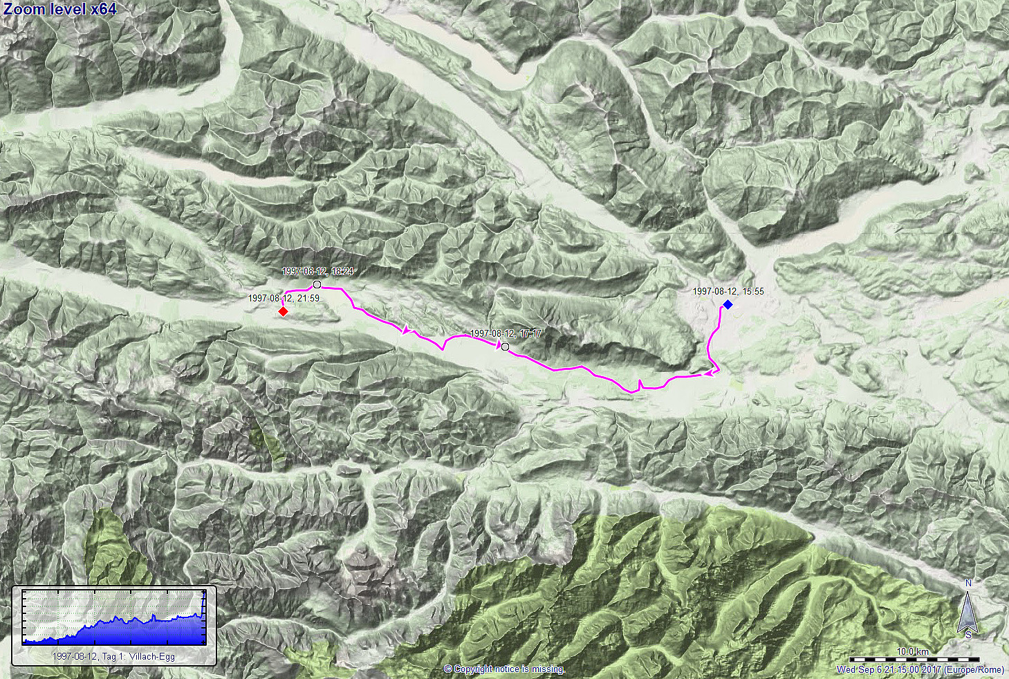 The plan of this multi-day bike trip was to cross the Alps, once again, from the south to the north, passing over the Glockner Hochalpenstrasse, which brings travelers up to 2500mosl! To start, we took the train from Wien to Villach, where we got onto our bikes at about 4pm in the afternoon. As a consequence of the comparably late start into this day 1, we only made a relatively short stretch on this day (about 65km). Surrounding the Dobratsch near Villach in its east and south, we entered the Gail-valley, which we then cycled westwards into the direction of Hermagor. After a little more than 3 hours of cycling, and passing by Pressegger See close to the end, we arrived in Egg, not far from Hermagor, where we stopped for the night.
More details about the entire bike-trip are available via >>>
The plan of this multi-day bike trip was to cross the Alps, once again, from the south to the north, passing over the Glockner Hochalpenstrasse, which brings travelers up to 2500mosl! To start, we took the train from Wien to Villach, where we got onto our bikes at about 4pm in the afternoon. As a consequence of the comparably late start into this day 1, we only made a relatively short stretch on this day (about 65km). Surrounding the Dobratsch near Villach in its east and south, we entered the Gail-valley, which we then cycled westwards into the direction of Hermagor. After a little more than 3 hours of cycling, and passing by Pressegger See close to the end, we arrived in Egg, not far from Hermagor, where we stopped for the night.
More details about the entire bike-trip are available via >>>
Biking across the Alps 1.2: Winkl-Krakaudorf
- Dato:
- 03.08.1995
- Turtype:
- Sykkeltur
- Turlengde:
- 13:15t
- Distanse:
- 90,2km
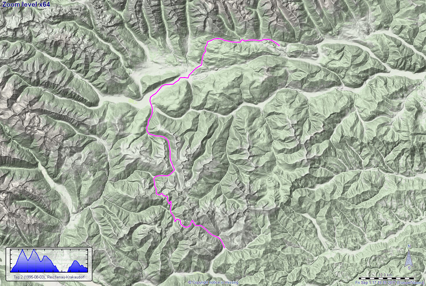 We started day 2 of this biking tour across the alps in Winkl near Ebene Reichenau with the goal to traverse the Nockberge first. We thus started on the Nockalmstrasse along the Stangenbach, heading for our first major pass on this tour, Schiesstlscharte (2025mosl). About two hours after starting our day, we eventually arrived at the pass, truly happy in all regards (beautiful nature, great views, and arriving at the pass after a strenuous ride). The next goal was then another nice pass in the Nockberge, not far from Schiesstlscharte, but with a significant "dive" into the Loebengraben in between (500 height meters down and then up again). After another two hours, we then arrived at this other pass, Steigerhöhe, at 2030mosl. All in all, we enjoyed the Nockberge a great lot, >>>
Biking across the Alps 1.1: Friesach-Winkl
- Dato:
- 02.08.1995
- Turtype:
- Sykkeltur
- Turlengde:
- 8:00t
- Distanse:
- 74,7km
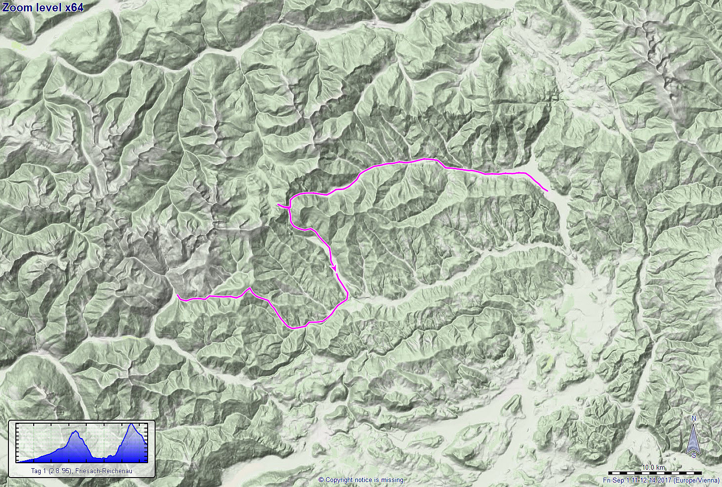 After having taken the train from Wien towards the south/southwest, we started cycling in Friesach. We quickly came into the Metnitz-valley, which we followed upwards in western direction. At the very end of the valley, we included a small detour (up to Flattnitz at 1400mosl), before we rushed down, now in southern direction, into the Glödnitz-valley. For a short stretch, we followed then the Gurk-valley, before changing into northwestern direction (Sirnitz). From there, we then started our ascent to the next pass on this tour, i.e., Hochrindl at 1580mosl. On the other, western side, then, we quickly descended into the Gurk-valley (again) and ended our first day tour in the vicinity of Ebene Reichenau.
More details about the entire bike-trip are available via a separate web page .
Route details about four >>>
After having taken the train from Wien towards the south/southwest, we started cycling in Friesach. We quickly came into the Metnitz-valley, which we followed upwards in western direction. At the very end of the valley, we included a small detour (up to Flattnitz at 1400mosl), before we rushed down, now in southern direction, into the Glödnitz-valley. For a short stretch, we followed then the Gurk-valley, before changing into northwestern direction (Sirnitz). From there, we then started our ascent to the next pass on this tour, i.e., Hochrindl at 1580mosl. On the other, western side, then, we quickly descended into the Gurk-valley (again) and ended our first day tour in the vicinity of Ebene Reichenau.
More details about the entire bike-trip are available via a separate web page .
Route details about four >>>
