Archiv - Nach Datum
Archiv - Nach Aktivität
-
Andere Tour (1)
- Kayaking (1)
-
Andere Wintertour (4)
- Schneeschuhtour (4)
-
Fahrradtour (137)
- Fahrradtour Straße (9)
- Fahrradtour gemischt (51)
-
Fußtour (740)
- Bergtour (363)
- Jogging (18)
- Spaziergang (89)
- Wanderung (270)
-
Skitour (4)
- Tourenskilauf (4)
Archiv - Nach Geografie
Peakbookfreunde


Gesammelte Listen
-
Bergen ≥ 50m pf. og ≥ 100 m.o.h.
(87/89)
 97%
97% -
Most dominating tops of the Bergen peninsula
(68/75)
90%
-
Utvalgte topper og turmål i Bergen
(316/350)
90%
-
Alle topper i Bergen
(357/398)
89%
-
Opptur Bergen
(100/113)
88%
-
De syv fjell rundt Bergen
(6/7)
85%
-
Sund ≥ 50m pf.
(14/18)
77%
-
Os ≥ 50m pf.
(25/34)
73%
-
Søyler (fastmerker) i Bergen
(68/100)
68%
-
Fjell ≥ 50m pf.
(21/32)
65%

A nice day in Wien
- Datum:
- 01.05.2026
- Tourcharakter:
- Fahrradtour gemischt
- Tourlänge:
- 2:00h
- Entfernung:
- 9,3km
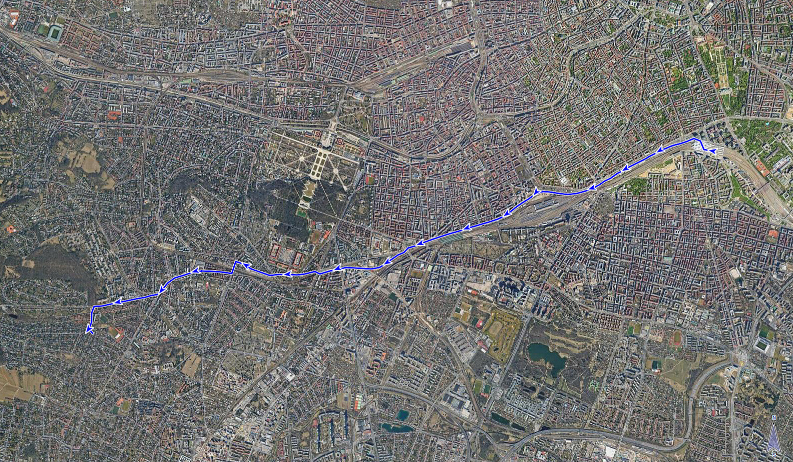
 We used this nice day to first bike to Karlsplatz, where we visited Albertina Modern and the KAWS exhibition there. Thereafter, we crossed through the first district of Vienna, also enjoying the world's best icecream at Tuchlauben, before then biking along Donaukanal to get back. Very nice! :-)
See also the related FB-page Hiking around Bergen, Norway .
We used this nice day to first bike to Karlsplatz, where we visited Albertina Modern and the KAWS exhibition there. Thereafter, we crossed through the first district of Vienna, also enjoying the world's best icecream at Tuchlauben, before then biking along Donaukanal to get back. Very nice! :-)
See also the related FB-page Hiking around Bergen, Norway .
Through Wien from Hauptbahnhof
- Datum:
- 29.04.2026
- Tourcharakter:
- Fahrradtour Straße
- Tourlänge:
- 0:45h
- Entfernung:
- 9,4km
 After first biking from Smolenice to Marchegg and then taking a train to Vienna, I still had to cover some 10km in Vienna. This worked as planned and there's nothing special to report about the route.
See also the related FB-page Hiking around Bergen, Norway .
After first biking from Smolenice to Marchegg and then taking a train to Vienna, I still had to cover some 10km in Vienna. This worked as planned and there's nothing special to report about the route.
See also the related FB-page Hiking around Bergen, Norway .
Through Wien to Donaukanal
- Datum:
- 26.04.2026
- Tourcharakter:
- Fahrradtour Straße
- Tourlänge:
- 1:00h
- Entfernung:
- 13,2km
 Main goal for this day was to get from Vienna to Smolenice (partly by boat, partly by bike). To first get to the boat (TwinCityLiner) in Vienna, I needed to bridge some 13km by bike in the early morning, first. Nothing special about the bike-route, though, to report.
Selected photos are available as Google photo album .
The TwinCityLiner is an interesting alternative option to get from Vienna to Bratislava (or the other way around).
Main goal for this day was to get from Vienna to Smolenice (partly by boat, partly by bike). To first get to the boat (TwinCityLiner) in Vienna, I needed to bridge some 13km by bike in the early morning, first. Nothing special about the bike-route, though, to report.
Selected photos are available as Google photo album .
The TwinCityLiner is an interesting alternative option to get from Vienna to Bratislava (or the other way around).
Wotruba Church and Hörndlwald
- Datum:
- 25.04.2026
- Tourcharakter:
- Fahrradtour gemischt
- Tourlänge:
- 2:00h
- Entfernung:
- 11,5km
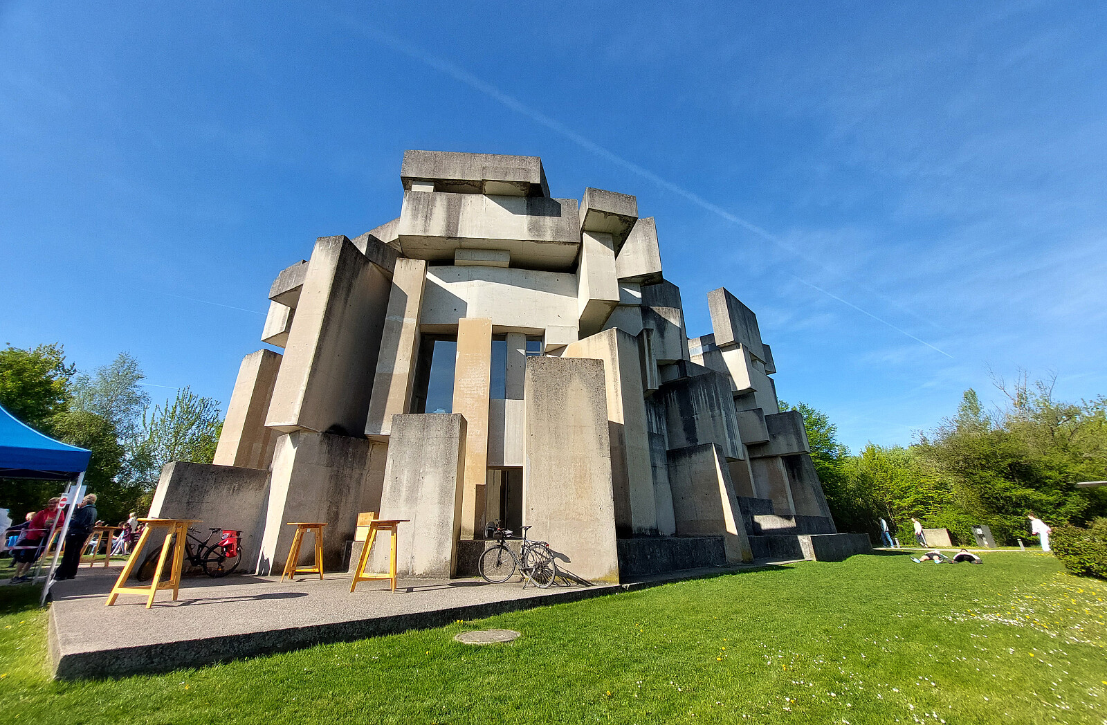 Just a short bike-ride to visit the Wotruba Church in the southwest of Vienna, followed by a nice (short) walk through Hörndlwald.
Selected photos are available as Google photo album .
There's a useful page about the Wotruba Church on Wikipedia .
Just a short bike-ride to visit the Wotruba Church in the southwest of Vienna, followed by a nice (short) walk through Hörndlwald.
Selected photos are available as Google photo album .
There's a useful page about the Wotruba Church on Wikipedia .
Donaupark, first, and then towards Mauer
- Datum:
- 06.11.2025
- Tourcharakter:
- Fahrradtour gemischt
- Tourlänge:
- 12:00h
- Entfernung:
- 40,3km
 I first biked to Austria Center Vienna for the conference, which I attended during these days. During the lunch break, I made a nice stroll through Donaupark right next to the conference center to catch some fresh air and some late autumn sun. After returning to Wien Landstrasse after the conference, my second goal of the day was to visit the southwest of Vienna. To get there, I biked via Margareten and along Edelsinnstrasse, before crossing over the railtracks for good to continue into the direction of Mauer. On my way back, I followed a similar route, just not descending into Margareten, again, but cycling along Wiedener Hauptstrasse instead.
Selected photos are available as Google photo album .
See also the related FB-page Hiking around Bergen, Norway .
I first biked to Austria Center Vienna for the conference, which I attended during these days. During the lunch break, I made a nice stroll through Donaupark right next to the conference center to catch some fresh air and some late autumn sun. After returning to Wien Landstrasse after the conference, my second goal of the day was to visit the southwest of Vienna. To get there, I biked via Margareten and along Edelsinnstrasse, before crossing over the railtracks for good to continue into the direction of Mauer. On my way back, I followed a similar route, just not descending into Margareten, again, but cycling along Wiedener Hauptstrasse instead.
Selected photos are available as Google photo album .
See also the related FB-page Hiking around Bergen, Norway .
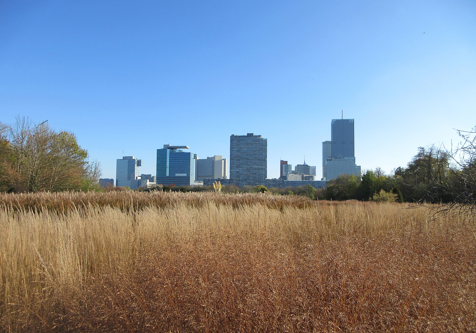
Bike excursion to Lobau
- Datum:
- 01.11.2025
- Tourcharakter:
- Fahrradtour gemischt
- Tourlänge:
- 2:30h
- Entfernung:
- 34,8km
 To refresh myself a little (before the next work session), I took the bike and made a quite excursion into Lobau, in the southeast of Vienna. I first biked into Prater and then over the Praterbrücke onto the Donauinsel, where I headed further towards Lobau in southeastern direction. After biking through Ölhafen Lobau, I eventually arrived at the nature reserve of Lobau. There, I explored a few paths, enjoying silence and nice nature. To get back, I took a different route, crossing over the Donau at the power station at Freudenau. This then brought me also to the rather peculiar Pagode right next to the Danube.
Selected photos are available as Google photo album .
See also the related FB-page Hiking around Bergen, Norway .
To refresh myself a little (before the next work session), I took the bike and made a quite excursion into Lobau, in the southeast of Vienna. I first biked into Prater and then over the Praterbrücke onto the Donauinsel, where I headed further towards Lobau in southeastern direction. After biking through Ölhafen Lobau, I eventually arrived at the nature reserve of Lobau. There, I explored a few paths, enjoying silence and nice nature. To get back, I took a different route, crossing over the Donau at the power station at Freudenau. This then brought me also to the rather peculiar Pagode right next to the Danube.
Selected photos are available as Google photo album .
See also the related FB-page Hiking around Bergen, Norway .
Jubiläumswarte and Mahnmal für die Opfer vom Spiegelgrund
- Datum:
- 25.10.2025
- Tourcharakter:
- Fahrradtour gemischt
- Tourlänge:
- 3:00h
- Entfernung:
- 32,8km
 I used my bike to visit the northwest of Vienna, biking first there, before eventually making a round to/from Jubiläumswarte on foot. One the way back, I then passed by the Mahnmal für die Opfer vom Spiegelgrund (memorial commemorating the victims at Spiegelgrund) at night, seeing the 772 steles lit for the first time. Clearly, it is very moving to visit this memorial at night!
Selected photos are available as Google photo album .
See also the related FB-page Hiking around Bergen, Norway .
Several other sites, including one at geschichtewiki.wien.gv.at and the one at gedenkstaettesteinhof.at remind of the grim history of Steinhof.
I used my bike to visit the northwest of Vienna, biking first there, before eventually making a round to/from Jubiläumswarte on foot. One the way back, I then passed by the Mahnmal für die Opfer vom Spiegelgrund (memorial commemorating the victims at Spiegelgrund) at night, seeing the 772 steles lit for the first time. Clearly, it is very moving to visit this memorial at night!
Selected photos are available as Google photo album .
See also the related FB-page Hiking around Bergen, Norway .
Several other sites, including one at geschichtewiki.wien.gv.at and the one at gedenkstaettesteinhof.at remind of the grim history of Steinhof.
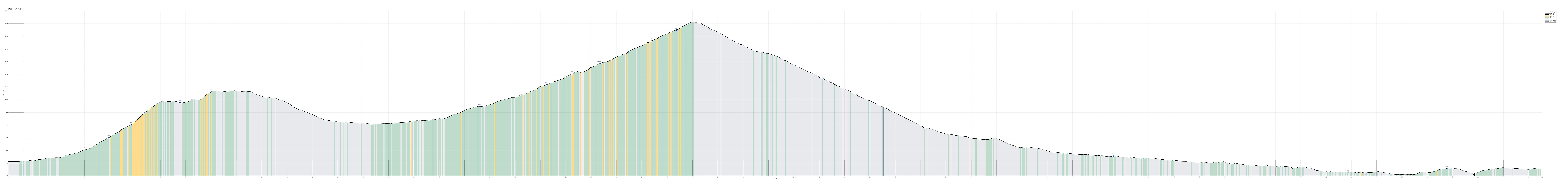
Back to Austria via Sella Nevea (from Moggio)
- Datum:
- 22.10.2025
- Tourcharakter:
- Fahrradtour
- Tourlänge:
- 7:30h
- Entfernung:
- 75,3km
 The plan for the fourth (and last) day of our four-days bike ride through the Julian Alps was to bike back to Austria from Moggio. Again, we started relatively early in Moggio to have enough time for the roughly 75km back (including the Selle Nevea mountain pass). This time, we were updated enough to understand that parallel to the main road (SS13) through the valley of Fiume Fella one can find the Alpe-Adri cycling path, which is using an abandoned train line! Using this cycling path, we nicely made it to Chiusaforte without any road stress! :-) Also, we could enjoy some nice sights along the way, including Ponte Peraria and several tall waterfalls. In Chiusaforte, we then said "Good bye!" to the cycling path and entered Val Raccolana towards Sella Nevea further in the east. While it was not raining, the clouds were >>>
From Erlendorf to Bovec via Wurzenpaß and Vršič
- Datum:
- 19.10.2025
- Tourcharakter:
- Fahrradtour
- Tourlänge:
- 7:00h
- Entfernung:
- 60,5km
 On the first (first real) day of our four-days bike ride through the Julian Alps , we aimed at biking from Erlendorf to Bovec over Wurzenpaß and Vršič. Starting at about 8h30 in the morning in Erlendorf, we headed for the street that leads up to Wurzenpaß immediately. After only about half a kilometer, it became clear that cycling up to Wurzenpaß would be harder than originally anticipated (the rather naive, initial idea was that Wurzenpaß would serve as a quick and not-too-hard warm-up exercise before going for the real pass over Vršič). Even though it was "only" about 500 height meters up from Erlendorf, the challenge was in the slopes, which topped out at about 18% (very steep for cycling indeed)! On Wurzenpaß, we stopped to look at an old tank right next to the road, which reminds visitors of WWII and the time >>>
Erlendorf-Arnoldstein and back
- Datum:
- 18.10.2025
- Tourcharakter:
- Fahrradtour
- Tourlänge:
- 2:00h
- Entfernung:
- 13,8km
 On the eve of our four-days bike ride through the Julian Alps , we arrived rather late in Erlendorf. To fill up some energy, not at the least for the coming day, we cycled over to Arnoldstein for some nice dinner. This short evening ride also served well as a test of the rental bike, which one of us had to use for these days.
See also the related FB-page Hiking around Bergen, Norway .
See also another page about this four-(five-)days bike trip .
On the eve of our four-days bike ride through the Julian Alps , we arrived rather late in Erlendorf. To fill up some energy, not at the least for the coming day, we cycled over to Arnoldstein for some nice dinner. This short evening ride also served well as a test of the rental bike, which one of us had to use for these days.
See also the related FB-page Hiking around Bergen, Norway .
See also another page about this four-(five-)days bike trip .
