Archiv - Nach Datum
Archiv - Nach Aktivität
-
Andere Tour (1)
- Kayaking (1)
-
Andere Wintertour (4)
- Schneeschuhtour (4)
-
Fahrradtour (137)
- Fahrradtour Straße (9)
- Fahrradtour gemischt (51)
-
Fußtour (740)
- Bergtour (363)
- Jogging (18)
- Spaziergang (89)
- Wanderung (270)
-
Skitour (4)
- Tourenskilauf (4)
Archiv - Nach Geografie
Peakbookfreunde


Gesammelte Listen
-
Bergen ≥ 50m pf. og ≥ 100 m.o.h.
(87/89)
 97%
97% -
Most dominating tops of the Bergen peninsula
(68/75)
90%
-
Utvalgte topper og turmål i Bergen
(316/350)
90%
-
Alle topper i Bergen
(357/398)
89%
-
Opptur Bergen
(100/113)
88%
-
De syv fjell rundt Bergen
(6/7)
85%
-
Sund ≥ 50m pf.
(14/18)
77%
-
Os ≥ 50m pf.
(25/34)
73%
-
Søyler (fastmerker) i Bergen
(68/100)
68%
-
Fjell ≥ 50m pf.
(21/32)
65%

Exploring the north of Maria Island
- Datum:
- 09.11.2023
- Tourcharakter:
- Fahrradtour gemischt
- Tourlänge:
- 6:00h
- Entfernung:
- 38,3km
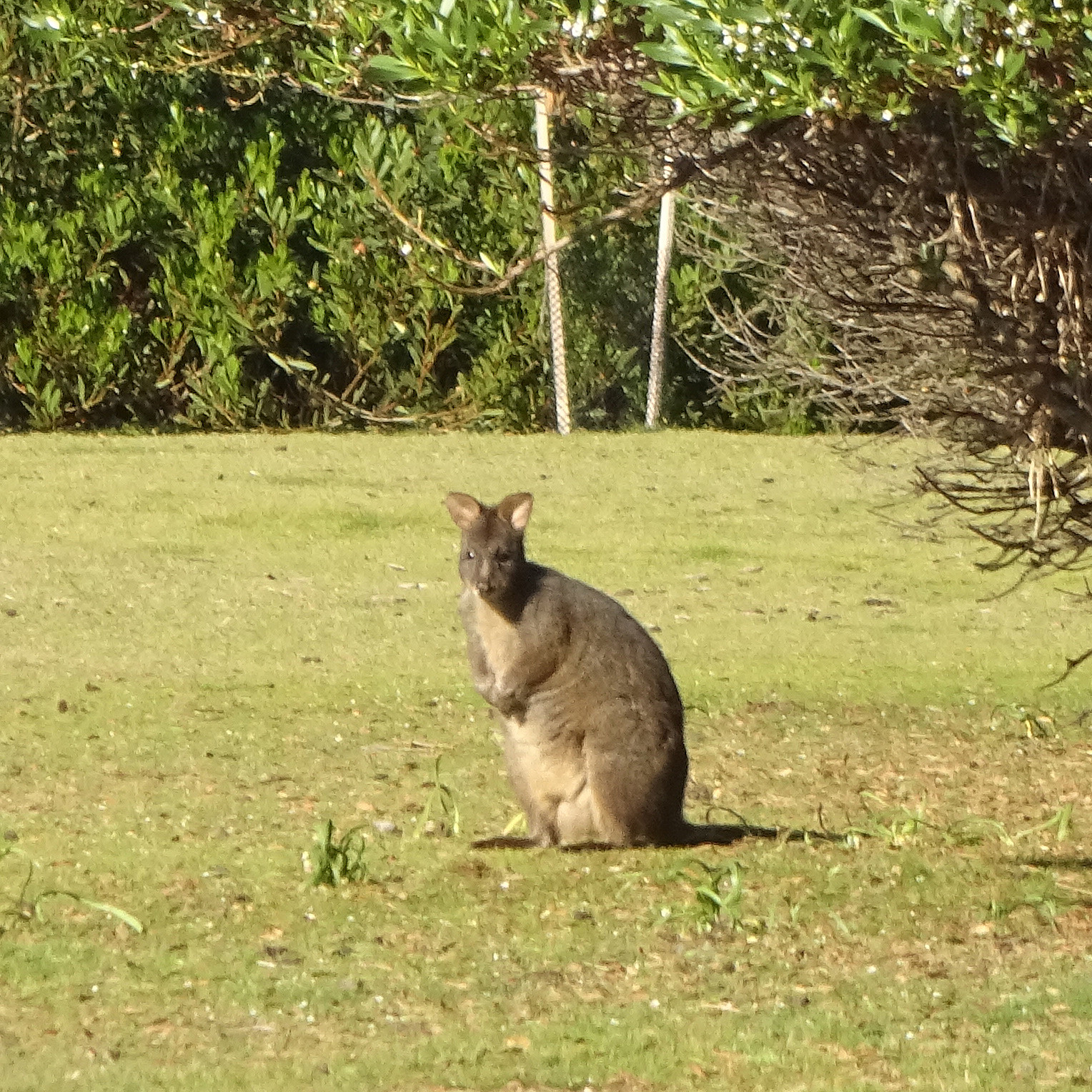
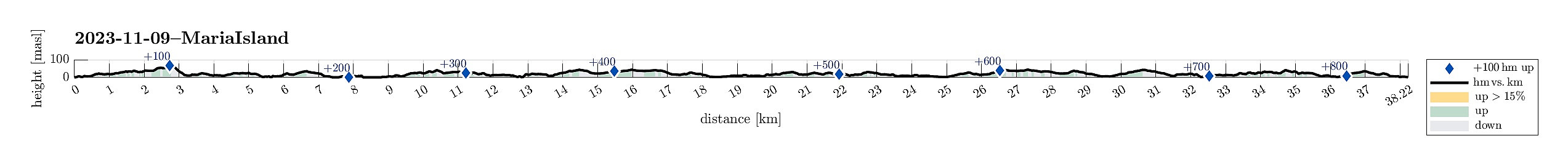 With one more day "to go", we decided to also include a trip to Maria Island, even though it not really was en route to Hobart. We stayed overnight in Triabunna, just a walking distance from the ferry quay. The next morning, we took the first ferry to Maria Island. Even though we had not booked any bikes in advance, we still hoped that we could get two bikes for the day anyway. Thus, after a mandatory short introduction to Maria Island, right after our arrival, we first headed for the bike rental in Darlington. Luckily, they weren't yet out of bikes, renting two of them out to us. :-) And this indeed was very nice -- Maria Island has quite a bit to offer and if one only has one day, then bridging distances between sights is definitely much more convenient per bike. After making >>>
Cape Raoul
- Datum:
- 07.11.2023
- Tourcharakter:
- Wanderung
- Tourlänge:
- 5:00h
- Entfernung:
- 17,9km
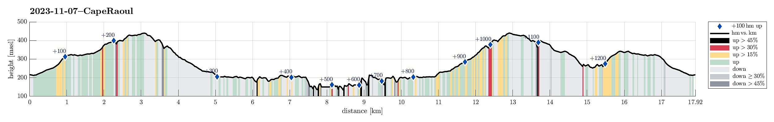 Plan two of our visit to the Tasman Peninsula was to hike out to Cape Raoul. We thus "switched over" from Fortescue Bay to Nubeena in the west of Port Arthur, and following the signs towards Cape Raoul from there, parking right next to the trail head, at about the end of the road, south of Stormlea. The very well marked trail to Cape Raoul leads first (gently) up (through the forest) to a nice vista point, Cape Raoul Lookout, high above the tall western cliffs of Mount Raoul. From there, it's then southwards (parallel to the cliffs) into the direction of Cape Raoul. We again had luck with the weather and enjoyed walking out there very much. Before actually getting to the southern-most tip of Cape Raoul, we passed by a particularly nice place ("The Gap"), where one (a) >>>
Cape Hauy
- Datum:
- 06.11.2023
- Tourcharakter:
- Wanderung
- Tourlänge:
- 3:30h
- Entfernung:
- 10,9km
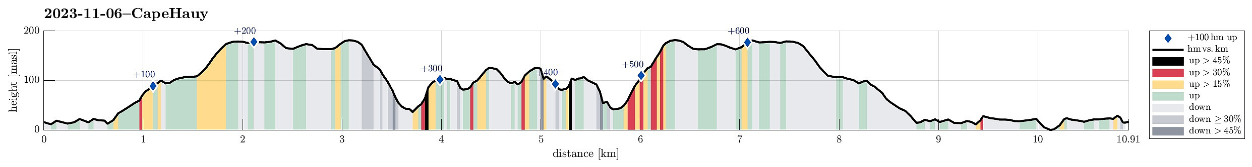 When doing the rough overall-planning of our trip through Tasmania, we had put down two major goals: the "Wild West" of Tasmania as well as the south-east (with either Bruny Island and/or the Tasman Peninsula). While changing over from the west to the southeast, we then decided to focus on the Tasman Peninsula (instead of trying too much in only a few days). Connecting to the Tasman Peninsula was easy and straight-forward from Hobart. We had seen that one can do several, also multiple days long hikes there, so we had to choose. First, we thought that we could explore Cape Hauy, starting from Fortescue Bay. To get there, we had to navigate a several kilometers long forest road (on gravel). While this was not 100% pleasant, it still was fully OK and we arrived in Fortescue Bay >>>
Short walk to Donaghys Hill
- Datum:
- 05.11.2023
- Tourcharakter:
- Bergtour
- Tourlänge:
- 1:00h
- Entfernung:
- 2,2km
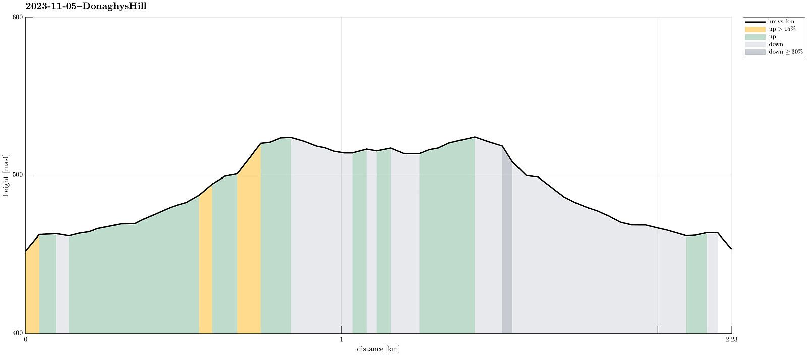 While we thought that we not really had sufficient time for an extended hike, this day, we still wished to see at least something along our drive through the Central Highlands. To do so, we followed a sign that suggested a short walk to Donaghys Hill in order to appreciate some nice views from its top. Parking right next to the highway, we first walked along a forest road, before turning right and into the forest along a regular trail. Not for the first time, and not for the last time in Tasmania, neither, we got very impressed by the very tall trees (and the jungle underneath them). Not far along this trail, we then stepped out of the forest and up onto Donaghys Hill. And indeed, it is true that this little hill offers surprisingly nice views, to the far (for ex., to Frenchmans Cap) as >>>
Unplanned Mount Owen
- Datum:
- 04.11.2023
- Tourcharakter:
- Wanderung
- Tourlänge:
- 3:00h
- Entfernung:
- 11,3km
 We had used most of the day to participate in a boat cruise on Macquarie Harbour (from Strahan), seeing the feared entry point (Hells Gates), the Gordon river (on the far, southeastern end of Macquarie Harbour) and the jungle around it, as well as Sarah Island (with all its dark history as a penal station). After all of this, we had no more plan than just driving a bit into the direction of the Central Highlands. Driving out of Strahan, we first headed towards Queenstown, which is strongly characterized by previous and current mining operations. This place did not appear inviting to us at all and we continued further eastwards (up the Lyell Highway Pass, first). As soon as we got close to the highest point on that saddle, we read a sign that hinted upon the opportunity to see a nice waterfall >>>
Visiting Montezuma Falls in the jungle
- Datum:
- 03.11.2023
- Tourcharakter:
- Spaziergang
- Tourlänge:
- 2:30h
- Entfernung:
- 9,5km
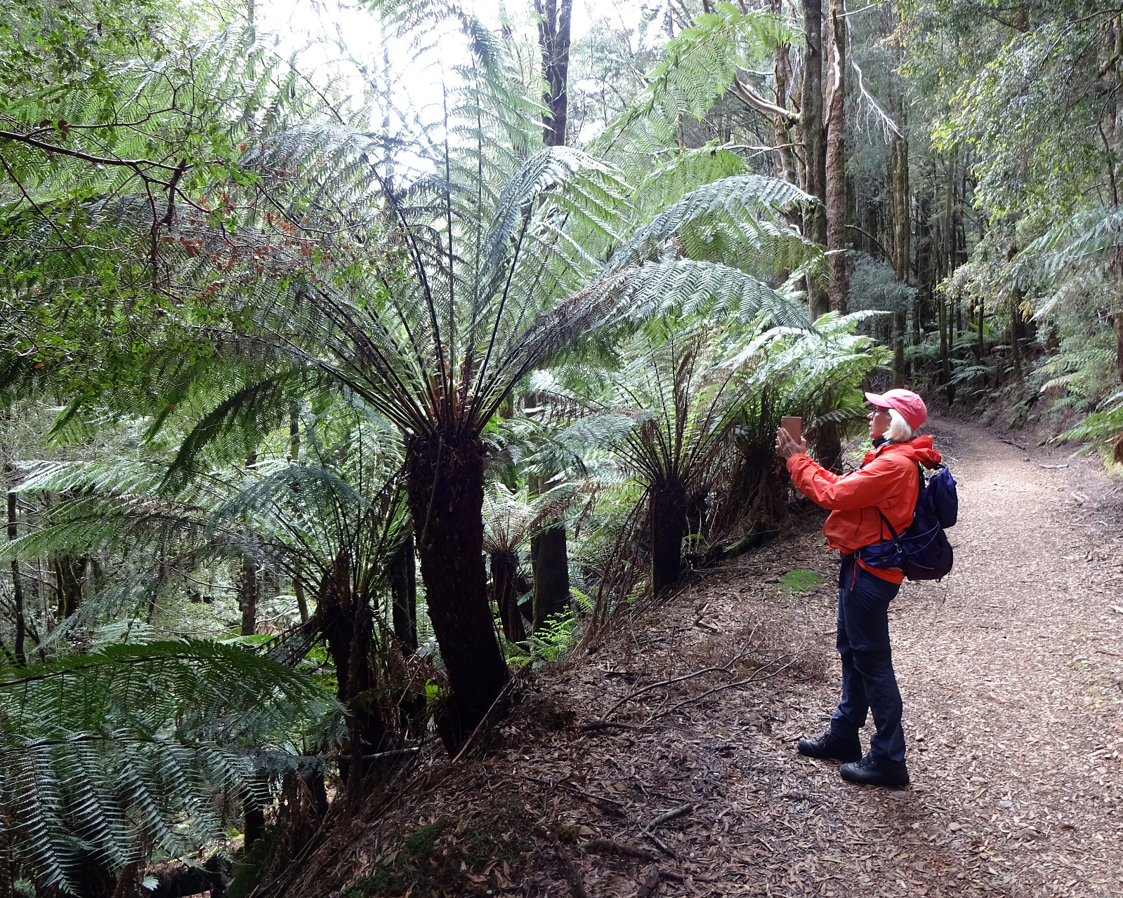 After our very nice hike up to Cradle Mountain on the day before, we headed further towards the west of Tasmania, driving (mostly) in southwestern direction. After first driving through large Eucalyptus forests, we then arrived in an impressive rain forest / jungle. Our main plan for the day, besides driving towards the west coast of Tasmania, was to do a hike into the jungle at Montezuma Falls. Leaving the main highway A10 near Rosebery, we used a minor road to get to the starting point of the Trail (where we also found a good spot to park). The trail to Montezuma Falls comes with an interesting bit of history, actually. It follows the route of an early-day railway that pioneers had built into the jungle to help with some mining activity in this area. Even though the topography of this area is definitely challenging (up >>>
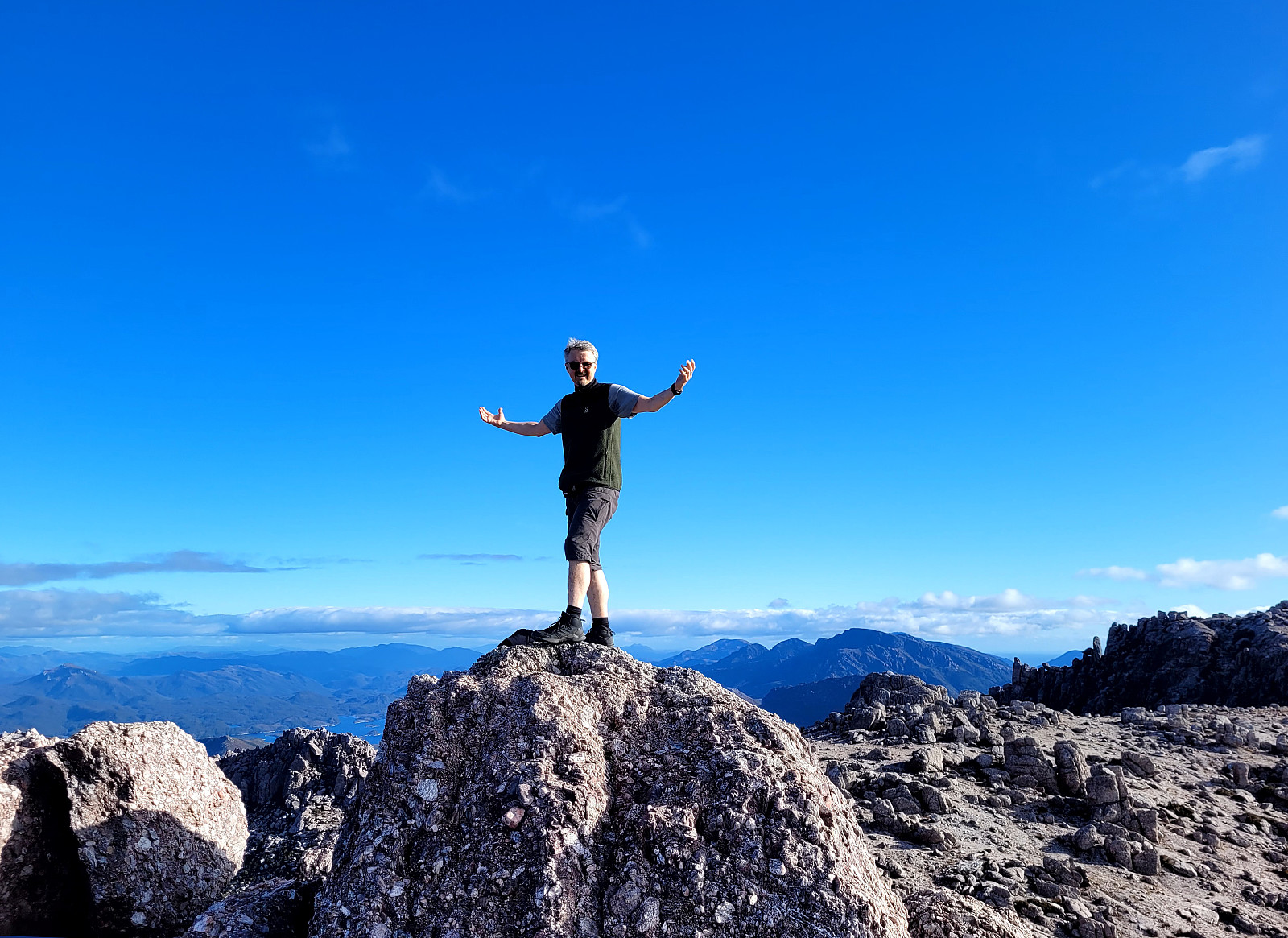
Cradle Mountain in lovely weather
- Datum:
- 02.11.2023
- Tourcharakter:
- Wanderung
- Tourlänge:
- 6:30h
- Entfernung:
- 13,1km
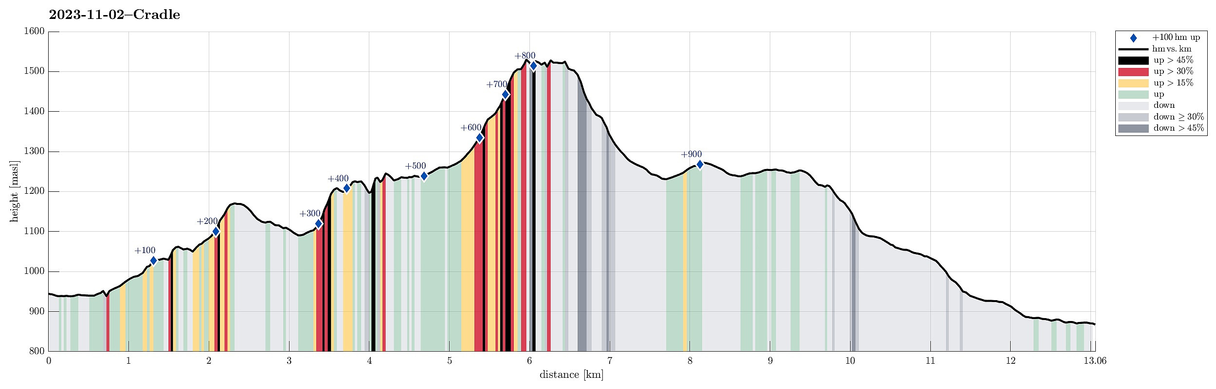 We started the day at the Cradle Mountain Visitor Centre at 4057 Cradle Mountain Road from where we took a shuttle bus up to the end of the road at Dove Lake. There, we first enjoyed beautiful views across the still lake, reflecting Cradle Mountain from behind and its surrounding landscape. We then started our hike on the east-side of Dove Lake, briefly checking out Glacier Rock, before then using the slightly minor trail up to Hansons Peak (Lake Rodway Track). Already this part was very nice, with views both across Dove Lake (to the west) as well as eastwards (once up on the ridge). From Hansons Peak, we then crossed over to the Face Track, which brought us, between Cradle Mountain in the south and Dove Lake in the north, to the west-side of Cradle Mountain. There, we connected to the >>>
Nice round through the Rocky Cape National Park
- Datum:
- 01.11.2023
- Tourcharakter:
- Wanderung
- Tourlänge:
- 6:00h
- Entfernung:
- 17,3km
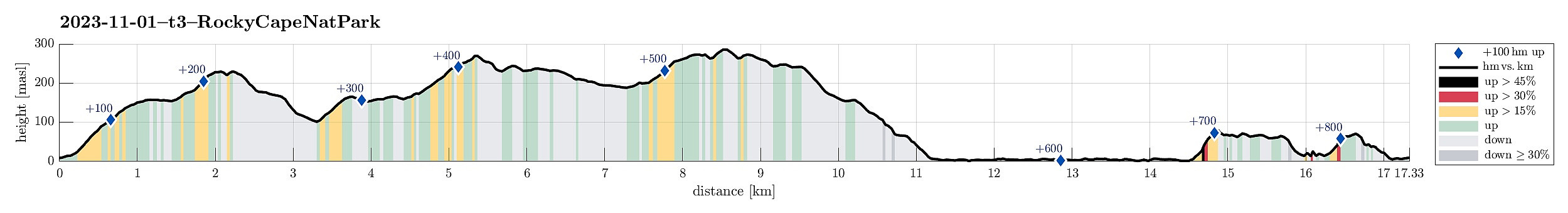 After a nice morning in Devonport, we decided to use the beautiful weather for a hike through Rocky Cape National Park. To get there, we followed the Bass Highway along the norther coast (in western, northwestern direction). In the area of Boat Harbour, we turned right and onto road C232 to Sisters Beach. In Sisters Beach, we oriented us towards the Boat Ramp (at the very northwestern end of Sisters Beach). There, we also found a good place to park the car. Since we had planned for a round through the Rocky Cape National Park, starting along the Inland route (over the hills), we aimed at the trailhead a few meters southwest of the parking place. After a few moments of searching this trailhead, we nicely located it along one of the sideroads. From there, it was then easy to follow the >>>
Mersey Bluff in Devonport
- Datum:
- 01.11.2023
- Tourcharakter:
- Spaziergang
- Tourlänge:
- 1:00h
- Entfernung:
- 1,5km
 Devonport had already welcomed us nicely and we decided to give it one more chance to shine! :-) Instead of heading out of town immediately, we first drove to the north of Devonport, where we thought to see the Mersey Bluff Lighthouse. Mersey Bluff and the beach right next to it did not disappoint us -- in fact, this area is really nice and clearly worth a short visit! :-) You can even shower yourself after swimming in the Bass Strait next to Mersey Bluff! Really nice! :-)
Selected photos are available as Google photo album .
See also the related FB-page Hiking around Bergen, Norway .
Devonport had already welcomed us nicely and we decided to give it one more chance to shine! :-) Instead of heading out of town immediately, we first drove to the north of Devonport, where we thought to see the Mersey Bluff Lighthouse. Mersey Bluff and the beach right next to it did not disappoint us -- in fact, this area is really nice and clearly worth a short visit! :-) You can even shower yourself after swimming in the Bass Strait next to Mersey Bluff! Really nice! :-)
Selected photos are available as Google photo album .
See also the related FB-page Hiking around Bergen, Norway .
Downtown Devonport
- Datum:
- 01.11.2023
- Tourcharakter:
- Spaziergang
- Tourlänge:
- 1:00h
- Entfernung:
- 2,3km
 After the whole night at the ferry from Geelong to Devonport, we wished to first get some fresh air (before driving on). We thus changed from East Devonport to West Devonport and made a nice stroll through down town Devonport, also enjoying a nice coffee for a breakfast! :-)
Selected photos are available as Google photo album .
See also the related FB-page Hiking around Bergen, Norway .
After the whole night at the ferry from Geelong to Devonport, we wished to first get some fresh air (before driving on). We thus changed from East Devonport to West Devonport and made a nice stroll through down town Devonport, also enjoying a nice coffee for a breakfast! :-)
Selected photos are available as Google photo album .
See also the related FB-page Hiking around Bergen, Norway .
