Archiv - Nach Datum
Archiv - Nach Aktivität
-
Andere Tour (1)
- Kayaking (1)
-
Andere Wintertour (4)
- Schneeschuhtour (4)
-
Fahrradtour (137)
- Fahrradtour Straße (9)
- Fahrradtour gemischt (51)
-
Fußtour (740)
- Bergtour (363)
- Jogging (18)
- Spaziergang (89)
- Wanderung (270)
-
Skitour (4)
- Tourenskilauf (4)
Archiv - Nach Geografie
Peakbookfreunde


Gesammelte Listen
-
Bergen ≥ 50m pf. og ≥ 100 m.o.h.
(87/89)
 97%
97% -
Most dominating tops of the Bergen peninsula
(68/75)
90%
-
Utvalgte topper og turmål i Bergen
(316/350)
90%
-
Alle topper i Bergen
(357/398)
89%
-
Opptur Bergen
(100/113)
88%
-
De syv fjell rundt Bergen
(6/7)
85%
-
Sund ≥ 50m pf.
(14/18)
77%
-
Os ≥ 50m pf.
(25/34)
73%
-
Søyler (fastmerker) i Bergen
(68/100)
68%
-
Fjell ≥ 50m pf.
(21/32)
65%

Okslevarden
- Datum:
- 01.08.2020
- Tourcharakter:
- Wanderung
- Tourlänge:
- 6:00h
- Entfernung:
- 9,7km
 When staying over night in Haugsvær, we were recommended to ascend to Gråsida from Indre Haugsdal. So that's what we did then! :-) We drove road E39 "back" south (into the direction of Bergen) and turned right in Matre (to leave E39 before entering Masfjordtunnelen). This brought us onto the old road and following it we entered Indre Haugsdal from Haugsdalvågen. Driving up this nice valley, we came by three particular hills (in the middle of the valley), which possibly gave the valley its name. Near Kjetland we crossed the river on an old stone bridge, turning right (into the direction of Storemyr) right after the bridge. Since we did not see any particular good parking opportunity next to this narrow road, we drove all the way to Storemyr and asked there. Luckily, we were >>>
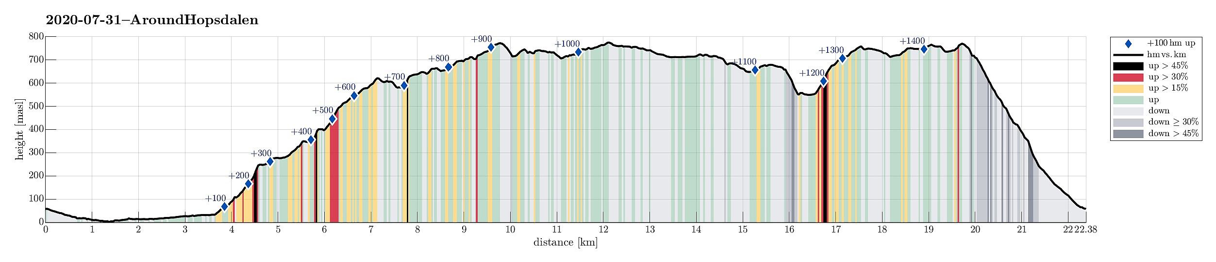
Around Hopsdalen
- Datum:
- 31.07.2020
- Tourcharakter:
- Wanderung
- Tourlänge:
- 8:30h
- Entfernung:
- 22,4km
 We drove along road E39 from Bergen northwards (into the direction of Masfjorden). After driving down through the long Masfjordtunnelen and passing through Matre at the very end of Matresfjorden, we crossed over to Haugsvær "behind" Nonklettfjellet. Before the main road (E39) disappears into another tunnel, we turned left in Haugsvær and parked right there.
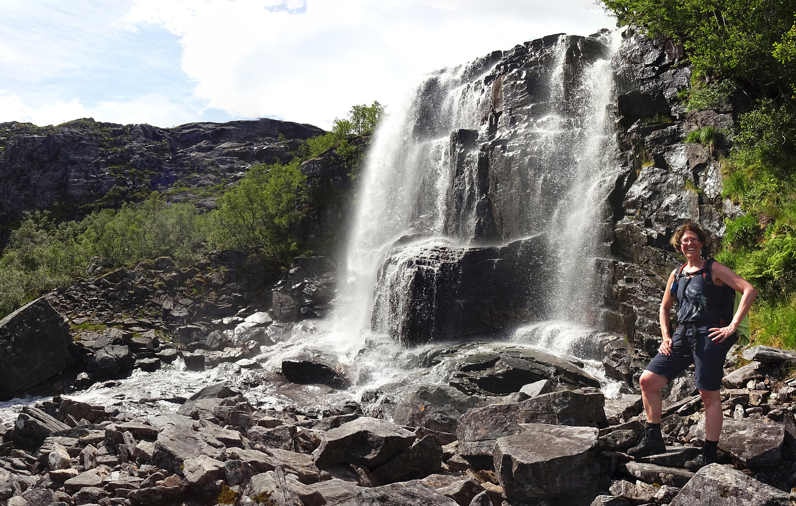
Our (slightly ambitious) plan for the afternoon was to go around Hopsdalen (from Høgfjellet via Grønefjellet to Gavlen, and back via Rustefjellet). Considering the steep sides of Hopsdalen, we had looked at the map regarding a possible place for getting up to the top of the surrounding mountains. Near Indre Skjerjehogen, on the north side of Haugsværfjorden, we had thought that it should be possible to reach saddle Sygnegga >>>
We drove along road E39 from Bergen northwards (into the direction of Masfjorden). After driving down through the long Masfjordtunnelen and passing through Matre at the very end of Matresfjorden, we crossed over to Haugsvær "behind" Nonklettfjellet. Before the main road (E39) disappears into another tunnel, we turned left in Haugsvær and parked right there.
Our (slightly ambitious) plan for the afternoon was to go around Hopsdalen (from Høgfjellet via Grønefjellet to Gavlen, and back via Rustefjellet). Considering the steep sides of Hopsdalen, we had looked at the map regarding a possible place for getting up to the top of the surrounding mountains. Near Indre Skjerjehogen, on the north side of Haugsværfjorden, we had thought that it should be possible to reach saddle Sygnegga >>>
