Archive - Date
Archive - Activity
-
Bike trip (137)
- Bike trip - mixed (51)
- Bike trip - road (9)
-
Other trip (1)
- Kayaking (1)
-
Other winter trip (4)
- Snowshoe trip (4)
- Ski trip (4)
- Trip by foot (740)
Archive - Geography
Peakbook-Friends


Collected lists
-
Bergen ≥ 50m pf. og ≥ 100 m.o.h.
(87/89)
 97%
97% -
Most dominating tops of the Bergen peninsula
(68/75)
90%
-
Utvalgte topper og turmål i Bergen
(316/350)
90%
-
Alle topper i Bergen
(357/398)
89%
-
Opptur Bergen
(100/113)
88%
-
De syv fjell rundt Bergen
(6/7)
85%
-
Sund ≥ 50m pf.
(14/18)
77%
-
Os ≥ 50m pf.
(25/34)
73%
-
Søyler (fastmerker) i Bergen
(68/100)
68%
-
Fjell ≥ 50m pf.
(21/32)
65%

Sauafjellet via Heiane from Rolsvåg
- Date:
- 05.04.2025
- Characteristic:
- Hike
- Duration:
- 5:45h
- Distance:
- 13.2km
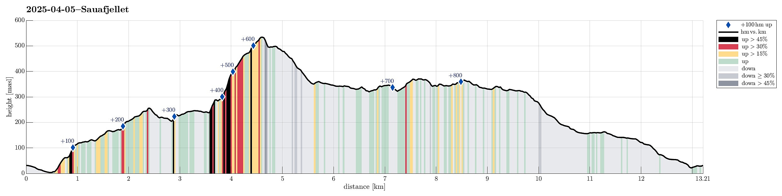 The idea was to visit Sauafjellet (from Rolsvåg). We parked near Vågasanden, right next to Solbjørgsvegen. The plan was to first hike to Heiane, in the southeast of Sauafjellet, before then connecting to the northeastern ridge of Sauafjellet. On the map, it had looked promising to start near Furneset (off trail) and then hike northwards up to Heiane. After getting around house 759 (and a dog that seemed moderately excited), we then made quick and nice progress upwards. Almost straight northwards, we soon found ourselves on Heiane, enjoying views already in all directions. As we had remembered from last time, a bit of careful navigation is recommended north of Heiane (the terrain is a bit rugged and several small lakes are around there, too). We still found a good traverse without >>>
Burlifjellet and Skorafjellet
- Date:
- 19.05.2024
- Characteristic:
- Hike
- Duration:
- 5:00h
- Distance:
- 11.1km
 Driving north from Fusa, into the direction of Samnanger, we passed through Eikelandsosen, first, continuing further northwards along road 48. At Sævell, right after passing by Sævellavatnet, we turned right onto Sævellvegen. Near Høgehaugen, we paid a bit of road-toll in order to continue along Sævellvegen. Driving carefully (Sævellvegen is not paved further inwards), we arrived at Kjøpmannavadet shortly after. There, right next to the bridge, we parked at the side of the road. Crossing over the bridge southwards, we started our hike along a forest road that leads to Breivatnet just a little down the road. There, one crosses over Breielva right next to a small cabin right at Breivatnet. A marked trail then leads up to Helane and from there further towards the lower end of Lisetredalen. >>>
Bergens lengste bakke, one of the classics near Bergen!
- Date:
- 09.09.2023
- Characteristic:
- Hike
- Duration:
- 5:15h
- Distance:
- 12.8km
 For a while, already, we had discussed that it absolutely was high time, again, for one of the nice classics in the vicinity of Bergen: up to Sydpolen from Brekkedalen! Since the weather seemed to hold throughout the day, we were quick to choose this hike for the day! :-) Driving into Hausdalen from E39 (south of Bergen), we aimed at the parking place at the very end of the road (basically where Brekkedalen splits off from Hausdalen). Hoping that we would not be too late to also find a free spot for our car, we then were relieved to actually find the parking place "only" half full (at about 11h). We quickly got started, heading into Brekkedalen along the gravel road. As soon as we approached Sandane, we also could look up to Sydpolen, already (always an impressive sight). Continuing >>>
Gråfjellet via Solbjørgfjellet from Rolsvåg
- Date:
- 05.03.2023
- Characteristic:
- Hike
- Duration:
- 6:00h
- Distance:
- 14.2km
 Expecting a nice day, we made a plan for a hike that would not lead us up into all too much snow. Having seen that Botnahytto (in the southwest of Rolsvåg, north of Os) was registered as war memorial, also, we decided to explore this area, including Gråfjellet in the east of Øvredalsvatnet. We had seen that others had taken the forest road from Rolsvåg (passing Rolsvågvatnet, also called Storavatnet, in its north) to get into the valley with Langavatnet and Botnavatnet. Motivated to make this a round, instead, we decided to start our hike in the south of Rolsvågvatnet, aiming for Solbjørgfjellet first. We parked very near to Rolsvågvatnet (on the east of it) and stepped into the terrain south of Rolsvågvatnet more or less "at once". The ground was still quite a bit frozen, >>>
Gullfjelltoppen via Glamregjelet
- Date:
- 19.11.2022
- Characteristic:
- Hike
- Duration:
- 4:30h
- Distance:
- 11.8km
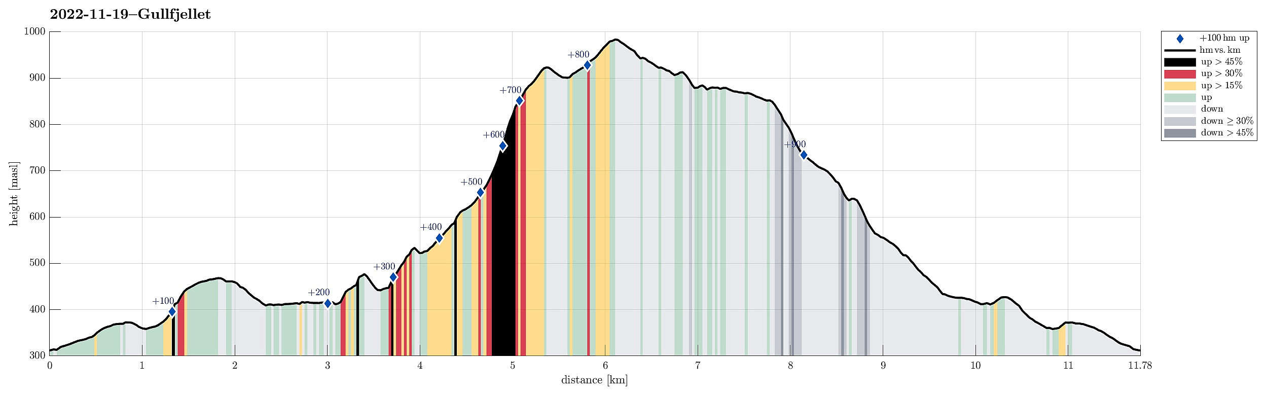 We expected a day with nice weather and decided to use it well. For a while, we had considered to ascend to Gullfjelltoppen via Glamregjelet, i.e., the valley in the northwest of Gullfjelltoppen. Assuming that the condition for exploring this route would be OK, we decided to try it. We started driving up Gullfjellsvegen to park at the parking place next to Osavatnet. From there, we first walked along the gravel road that leads up to the dam of Svartavatnet. Instead of following the "main road", which leads further up to Redningshytten, we took the convenient stairs up on the northern side of the dam, arriving close to the water level of Svartavatnet in the south of Svartavassrinden. While one of the two of us continued "horizontally", following the northwestern shore >>>
Sveningen via Åsen from Brekkedalen
- Date:
- 12.09.2021
- Characteristic:
- Hike
- Duration:
- 6:30h
- Distance:
- 13.2km
 The weather forecast has been promising (very promising), even in the morning, so what could go wrong? :-)
Considering the expected day full of sunshine and pleasant hiking temperatures, we aimed at something slightly "bigger" and since we had not visited Sveningen recently, we planned a nice hike over this mountain! To make this a bit more interesting, we decided to include an ascent that we had not tried before (and of which we also could not find any other report from others), i.e., up to Åsen, first, from the north, and then over the northernmost part of the Sveningen massif (in eastwards direction, kind of "parallel" to Brekkedalen in the north of it). To get started, we drove into Hausdalen (from E39, south of Bergen) and all the way into it (until the parking >>>
The weather forecast has been promising (very promising), even in the morning, so what could go wrong? :-)
Considering the expected day full of sunshine and pleasant hiking temperatures, we aimed at something slightly "bigger" and since we had not visited Sveningen recently, we planned a nice hike over this mountain! To make this a bit more interesting, we decided to include an ascent that we had not tried before (and of which we also could not find any other report from others), i.e., up to Åsen, first, from the north, and then over the northernmost part of the Sveningen massif (in eastwards direction, kind of "parallel" to Brekkedalen in the north of it). To get started, we drove into Hausdalen (from E39, south of Bergen) and all the way into it (until the parking >>>
Holdhusfjellet from Raunekleiva
- Date:
- 24.04.2021
- Characteristic:
- Hike
- Duration:
- 5:00h
- Distance:
- 11.4km
 The plan was to hike Holdhusfjellet from the south. To do so, we took the car into the east of Bergen, driving along E16 first. At Trengereid, we changed to road #7, driving towards Samnanger (via Gullbotn). After passing by Gullbotn, but before getting all the way down to Samnanger (just east of Hisdalen), we parked right next to the recycling area at Raunekleiva (we expected to come down there, following the prominent trail that leads to Raudvatnet from there). From there, we first walked along the old road back along Samnangervegen in westward direction. Walking by Leitet and Hisdalen, we approached the steep southeastern slopes of Holdhusfjellet. Ahead of time, we had discussed about how to actually ascend to Holdhusfjellet. One idea was to ascend to Akselskaret, first, and from >>>
Gullfjelltoppen via Gulltjørna and Storegga
- Date:
- 18.10.2020
- Characteristic:
- Hike
- Duration:
- 6:00h
- Distance:
- 13.8km
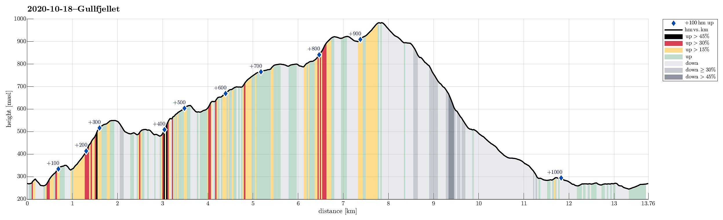 We looked forward to a cold but sunny autumn Sunday and thus planned a hike "with high expectations"! :-) While we had earlier hiked quite a bit "here and there" in the Gullfjellet area, we not yet had traversed Storegga (in the north of Gullfjelltoppen). Thus we had a plan! :-) To make this hike a nice round, we aimed to start at the saddle between Trengereiddalen and Gullbotn, then traverse (without a trail) to Gulltjørna, before then ascending Gråfjellet and from there Storegga. After that, our plan was to hike down the major trail between Gullfjelltoppen and Gullbotn.
We left Bergen to the East, following E16 from Arna until the roundabout near Trengereid, where we turned right (in southern direction). We then drove up Trengereiddalen until we came to the saddle >>>
We looked forward to a cold but sunny autumn Sunday and thus planned a hike "with high expectations"! :-) While we had earlier hiked quite a bit "here and there" in the Gullfjellet area, we not yet had traversed Storegga (in the north of Gullfjelltoppen). Thus we had a plan! :-) To make this hike a nice round, we aimed to start at the saddle between Trengereiddalen and Gullbotn, then traverse (without a trail) to Gulltjørna, before then ascending Gråfjellet and from there Storegga. After that, our plan was to hike down the major trail between Gullfjelltoppen and Gullbotn.
We left Bergen to the East, following E16 from Arna until the roundabout near Trengereid, where we turned right (in southern direction). We then drove up Trengereiddalen until we came to the saddle >>>
Krånipa, Raudnipa, and Hananipa (from Gullbotn)
- Date:
- 19.09.2020
- Characteristic:
- Hike
- Duration:
- 7:30h
- Distance:
- 17.7km
 After a quite rainy period, we looked forward to a weekend with some nice weather. After weighing several hiking ideas against each other, we settled on a slightly longer hike over three Nipa-mountains in the East of Gullbotn. Driving along E16 from Arna, we turned right and up towards Gullbotn near Trengereid. Once above the saddle, we left the road at Gullbotn and parked right there (quite a number of parking places there). According to our plan (Krånipa first), we first headed in northern direction to get around Øyjordsvatnet. Almost exactly where Teinelva enters Øyjordsvatnet, we used a convenient bridge for pedestrians to get over to the other, eastern side. There, we turned left, again, to head for a small valley that runs south-north in the west of Skåpet. While passing by >>>
Kofta (and Gullfjellet) from Nordbø
- Date:
- 20.06.2020
- Characteristic:
- Hike
- Duration:
- 6:00h
- Distance:
- 12.6km
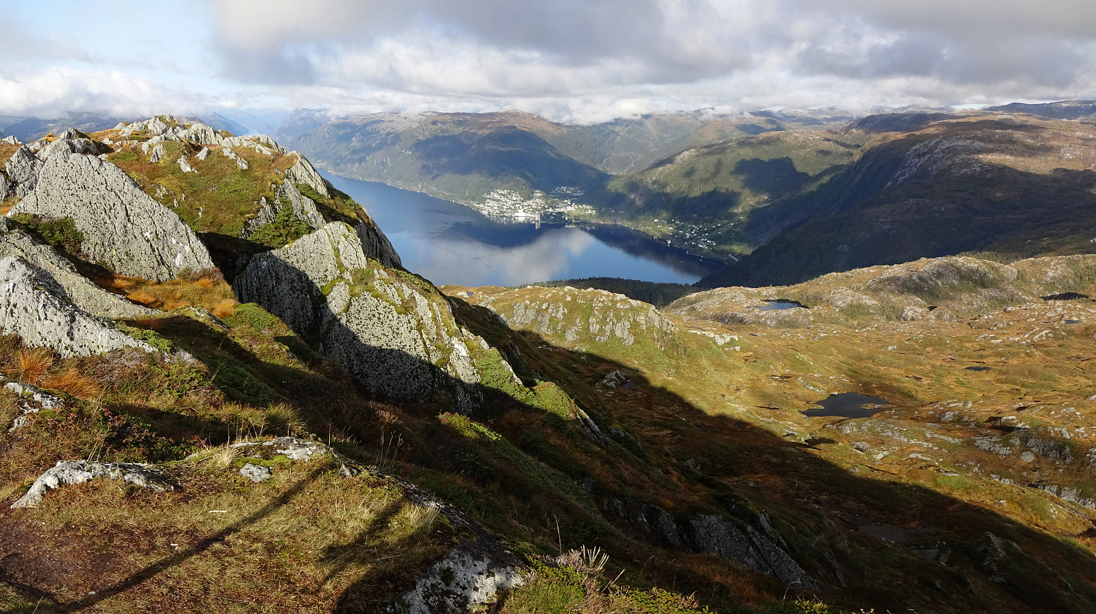
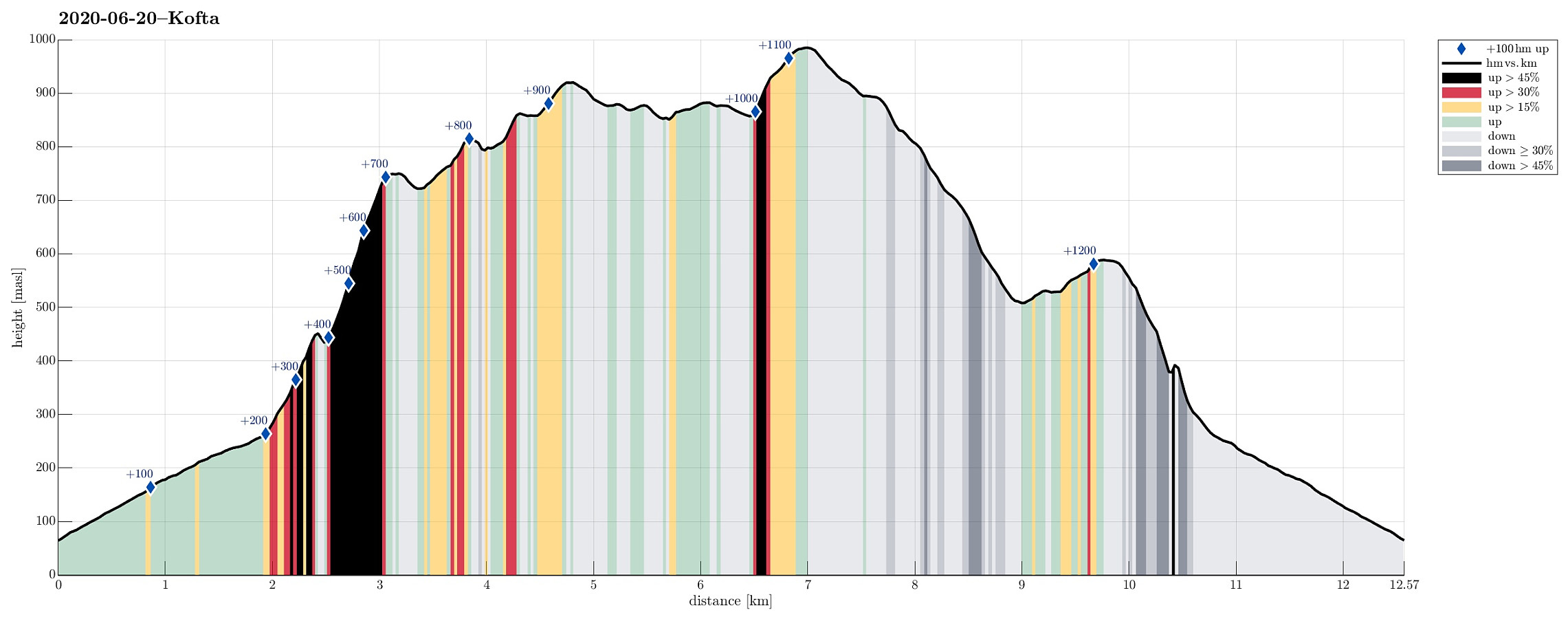 For at least two years, already, we had (occasionally) considered this hike: Kofta from Nordbøbotnen. After a relaxing morning, and knowing that the days are (very) long at this time of the year, we decided to go and do it. We drove from Bergen (via E16 first, then across Gullbotn) and left road #7 right after Hisdalstunnelen (to the right), where it leads on into the direction of Osøyro. Driving down road #137 for only a short stretch, we came to Nordbø, where we turned right (again), now in northern direction. From there, we continued for just about 850m, or so, until we had passed the last house. There, before entering the forest, we parked next to the road. We first walked along the forest road (the same road that we had come in with the car further down) up to about 200mosl (only >>>
