Archive - Date
Archive - Activity
-
Bike trip (137)
- Bike trip - mixed (51)
- Bike trip - road (9)
-
Other trip (1)
- Kayaking (1)
-
Other winter trip (4)
- Snowshoe trip (4)
- Ski trip (4)
- Trip by foot (740)
Archive - Geography
Peakbook-Friends


Collected lists
-
Bergen ≥ 50m pf. og ≥ 100 m.o.h.
(87/89)
 97%
97% -
Most dominating tops of the Bergen peninsula
(68/75)
90%
-
Utvalgte topper og turmål i Bergen
(316/350)
90%
-
Alle topper i Bergen
(357/398)
89%
-
Opptur Bergen
(100/113)
88%
-
De syv fjell rundt Bergen
(6/7)
85%
-
Sund ≥ 50m pf.
(14/18)
77%
-
Os ≥ 50m pf.
(25/34)
73%
-
Søyler (fastmerker) i Bergen
(68/100)
68%
-
Fjell ≥ 50m pf.
(21/32)
65%

Gjønakvitingen from Gjøn (via Selfjellet)
- Date:
- 17.08.2025
- Characteristic:
- Hike
- Duration:
- 8:00h
- Distance:
- 13.5km
 The weather was promising and so we thought this would be a good day to hike up to Gjønakvitingen from Gjøn. From Bergen, we drove towards the East, first along E16, then road #49, before taking road #48 to Eikelandsosen. From there, it was not too far, continuing into eastern direction, before we changed to a narrow road at Holdhus. This way, we drove around the south end of Gjønavatnet in order to get to Gjønavegen, which brought us to Gjøn. At about noon-time, we then started our hike (with enough time on such a nice, long summer Sunday). The one, small "twist", which we had cooked up, when studying the map at home, was to include Selfjellet (via an ascent on the western side of Skarvaelva), before eventually taking the "main trail" down (south of Sauaskorfjellet). >>>
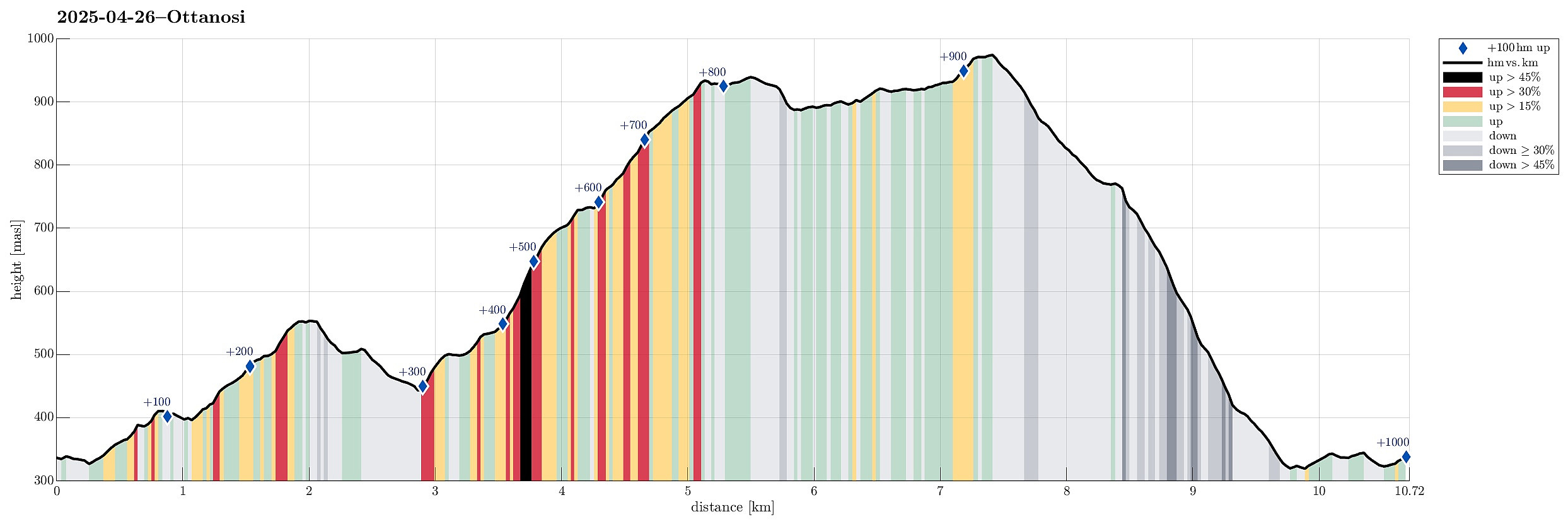
Heihillerhornet, Kjerringafjellet, and Ottanosi
- Date:
- 26.04.2025
- Characteristic:
- Hike
- Duration:
- 5:30h
- Distance:
- 10.7km
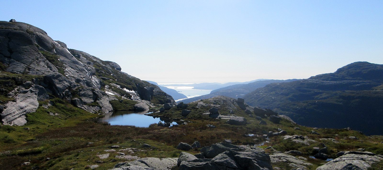
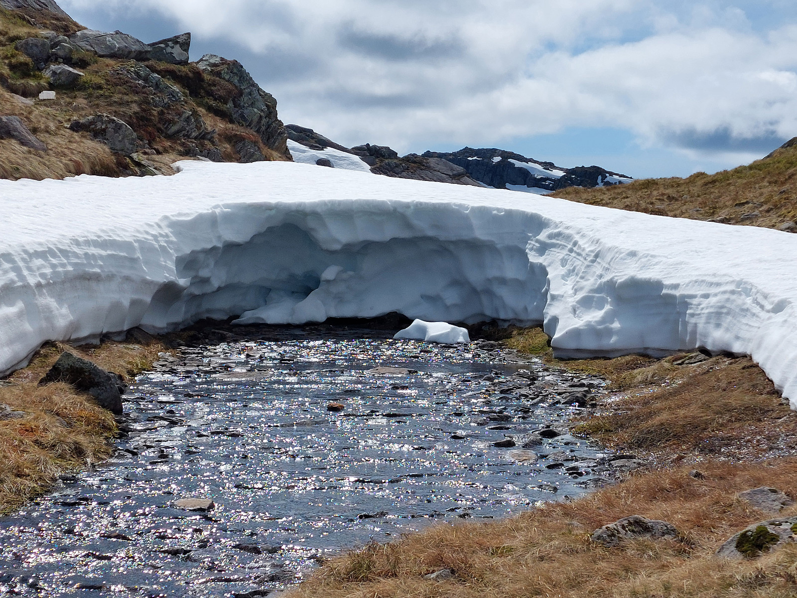
 We expected nice weather and thus planned for a nice hike! :-) We took the ferry from Hatvik near Os in the south of Bergen to Venjaneset in Fusa. From there, we first drove to Eikelandsosen and then to Holdhus, where we left road 48 to get up to the parking place at Heihillervegen (one pays some road fee for driving up there: NOK 75 plus about the same amount "on top" for "lagring og oppslag" as well as for "fakturagebyr"). Our first goal was to hike up to Heihillerhornet and so we "retreated" from the parking place a short stretch along the road to the place, where the trail starts (there's a sign, also). After first finding the trail head, we still managed to get off the trail within only meters from the road! :-) Instead of heading further eastwards, >>>
Burlifjellet and Skorafjellet
- Date:
- 19.05.2024
- Characteristic:
- Hike
- Duration:
- 5:00h
- Distance:
- 11.1km
 Driving north from Fusa, into the direction of Samnanger, we passed through Eikelandsosen, first, continuing further northwards along road 48. At Sævell, right after passing by Sævellavatnet, we turned right onto Sævellvegen. Near Høgehaugen, we paid a bit of road-toll in order to continue along Sævellvegen. Driving carefully (Sævellvegen is not paved further inwards), we arrived at Kjøpmannavadet shortly after. There, right next to the bridge, we parked at the side of the road. Crossing over the bridge southwards, we started our hike along a forest road that leads to Breivatnet just a little down the road. There, one crosses over Breielva right next to a small cabin right at Breivatnet. A marked trail then leads up to Helane and from there further towards the lower end of Lisetredalen. >>>
Kletten from Strandvik
- Date:
- 18.05.2024
- Characteristic:
- Walk
- Duration:
- 0:30h
- Distance:
- 2.2km
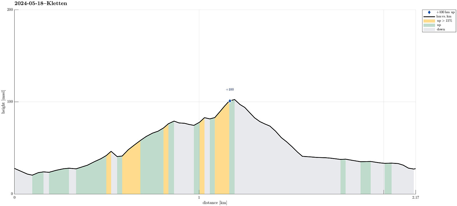 The evening was nice and with plenty of daylight still to use it was just fine with a short round up to Kletten before calling it a day. :-) The plan was to approach Kletten from the east (from Strandvik) and doing so was (almost) straight-forward. Only once, at the very end of Strandvikvegen at house 529, a bit of back-tracking was needed to reconnect with the trail (that is starting a bit further north). Then, instead of going up to Kletten at once, I first surrounded Kletten via Klettaltanen in its south, before eventually ascending to Kletten (then from its west). After crossing over Kletten, I then descended northwards to Strandvikvegen, which I then followed back to Strandvik. Quite nice that one can see Melderskin and Englafjellet from Kletten! :-)
Selected photos are available >>>
The evening was nice and with plenty of daylight still to use it was just fine with a short round up to Kletten before calling it a day. :-) The plan was to approach Kletten from the east (from Strandvik) and doing so was (almost) straight-forward. Only once, at the very end of Strandvikvegen at house 529, a bit of back-tracking was needed to reconnect with the trail (that is starting a bit further north). Then, instead of going up to Kletten at once, I first surrounded Kletten via Klettaltanen in its south, before eventually ascending to Kletten (then from its west). After crossing over Kletten, I then descended northwards to Strandvikvegen, which I then followed back to Strandvik. Quite nice that one can see Melderskin and Englafjellet from Kletten! :-)
Selected photos are available >>>
Fusafjellet from Strandvik
- Date:
- 18.05.2024
- Characteristic:
- Hike
- Duration:
- 6:00h
- Distance:
- 16.5km
 Given a very nice (and warm!) day, we aimed at hiking Fusafjellet from the south, starting in Strandvik. We first headed into the valley between Fusafjellet in the northeast and Bogafjellet in the west, where Vikaelva comes down. At about 80 masl, in the northeast of Nyland, the valley opens up a little and we left the main gravel road, stepping "directly north", aiming at the little saddle in the east of the small hill that "sits" there in the middle of the valley. The plan was to continue further upwards (into the direction of Langnuen) from there, but before we did that we first explored this little hills for a few minutes, enjoying some nice views southwards from it. We then followed a forest road that ascends the relatively steep southwestern side of Langnuen. >>>
Tåkenuten and Kråkenos
- Date:
- 23.05.2020
- Characteristic:
- Hike
- Duration:
- 6:15h
- Distance:
- 13.4km
 Weighing the weather forecast with our wish to make a nice hike, we ended up with Kråkenos as our hiking goal. While this mountain is also well accessible from its eastern side (from Bru near Strandebarm at Hardangerfjorden), we decided to approach it from its western side, i.e., from Øvre Hålandsdalen. To get there, we drove from Bergen first along E16 into the direction of Voss, then along road 49 into the direction of Kvamskogen, before then continuing along road 48 to Eikelandsosen and from there further towards Holdhus a few kilometers in the east of Eikelandsosen. Near Holdhus one needs to take a sharp turn to the left (north) onto an old and narrow road that leads into Øvre Hålandsdalen (after first passing between Gjønavatnet in the north and Skogseidvatnet in the south). >>>
Skarsnuten, Vardafjellet, Grytefjellet, and Belgjaråsen
- Date:
- 30.04.2019
- Characteristic:
- Hillwalk
- Duration:
- 5:45h
- Distance:
- 14.8km
 After a meeting at Solstrand Bad & Hotel, we decided to do a hike in nearby Fuse before heading back to Bergen. From Hattvik, we thus took the ferry over to Venjaneset and drove from there further along road 552 towards Eikelandsosen. There we took to the left (onto road 48 and into the direction of Samnanger) and continued on it for a few kilometers (until we had come through Moshovdatunnelen). Right after the tunnel, we turned right (onto Hafskorvegen) and parked soon after (very near to the bridge that we had just passed over after the tunnel).
Our first hiking goal was Skarsnuten, a little top "in the valley", south of Hafskorvatnet. It was nice that we could see the top from the very start of the hike, also. We first followed the little road that leads up to Hafskorvatnet, >>>
After a meeting at Solstrand Bad & Hotel, we decided to do a hike in nearby Fuse before heading back to Bergen. From Hattvik, we thus took the ferry over to Venjaneset and drove from there further along road 552 towards Eikelandsosen. There we took to the left (onto road 48 and into the direction of Samnanger) and continued on it for a few kilometers (until we had come through Moshovdatunnelen). Right after the tunnel, we turned right (onto Hafskorvegen) and parked soon after (very near to the bridge that we had just passed over after the tunnel).
Our first hiking goal was Skarsnuten, a little top "in the valley", south of Hafskorvatnet. It was nice that we could see the top from the very start of the hike, also. We first followed the little road that leads up to Hafskorvatnet, >>>
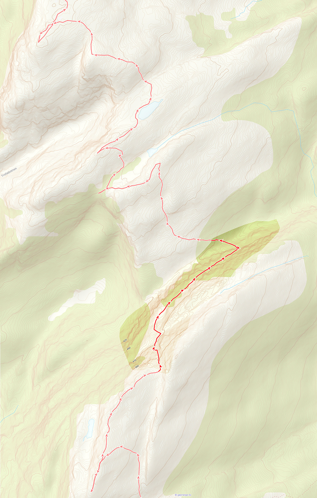
Bogafjellet from Reinsvegen
- Date:
- 18.11.2018
- Characteristic:
- Hillwalk
- Duration:
- 3:45h
- Distance:
- 11.3km
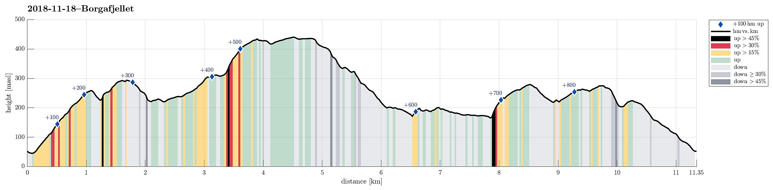 Even though the weather, with very low hanging clouds, did not look all to promising for a hike somewhere higher up, I still decided to give it a try and headed south and towards Fusa (via Osøyro, then taking the ferry from Hatvik to Senjaneset). Even on the ferry across Fusafjorden I wondered, whether it was that good an idea at all (the impression which the sun made, breaking through the low-hanging clouds, however, was definitely worth the view!). After arriving in Fusa, I quickly turned right from the main road and followed road 122 towards Strandvik (via Vinnes). Before actually getting to the "center" of Strandvik, I turned left and headed towards Reinsvegen. Passing by Kvåle, I drove up the valley until a spot near Snøhaugen. From there, I had planned to hike a round >>>
Tveitakvitingen from Tveita
- Date:
- 09.10.2016
- Characteristic:
- Hillwalk
- Duration:
- 7:00h
- Distance:
- 16.4km
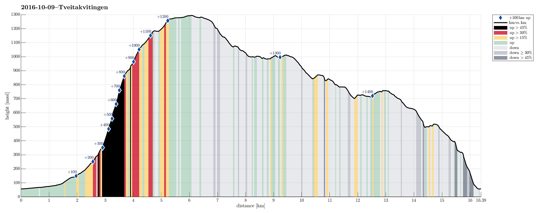 We took E16 from Bergen to Trengereid, then following road number 7 to Samnanger, before changing over to road number 48 right after Hagaåstunnelen. We passed through Eikelandsosen and continued to Holdhus, where we changed to a small road, which would lead us into the Tveita valley. Once there, we continued almost all the way in and parked near Bratthus, close to Indre Tveita. From there, we walked the rest of the road into the end of this nice valley, passing the last farm at Brekka soon after. The way continues into Tveitaskaret, where it becomes steep very soon (but easy to hike---mostly, because a gravel road has been constructed---probably to help maintaining a small power station that was opened in Tveitaskaret in 2009). At the end of the gravel road, one can further ascend through >>>
Fusafjellet
- Date:
- 30.08.2015
- Characteristic:
- Hillwalk
- Duration:
- 6:30h
- Distance:
- 17.4km
 We took the ferry from Hattvik to Venjaneset and continued -- only a little less than 3km -- to Fusa. We parked the car right next to the street, where it crosses Sagelva and where a sign points towards the old postal path (gamle postveien) -- not at the least as also recommended by the page about Storehorga and Langenuen on WestCoastPeaks.com . We first went up a simple street called Øpstad (on the eastern side of Sagelva), which connects directly to a useful forest road, leading up the valley. At about 125mosl, we came to a road fork, continuing on the left, further up. At about 300mosl, another trail fork opens up for different alternatives -- we turned left, again, following the most direct route up to Fusafjellet (from there). Ascending a little further from there, we left the tree line below us and started to enjoy the many nice views that >>>
