Archiv - Nach Datum
Archiv - Nach Aktivität
-
Andere Tour (1)
- Kayaking (1)
-
Andere Wintertour (4)
- Schneeschuhtour (4)
-
Fahrradtour (137)
- Fahrradtour Straße (9)
- Fahrradtour gemischt (51)
-
Fußtour (740)
- Bergtour (363)
- Jogging (18)
- Spaziergang (89)
- Wanderung (270)
-
Skitour (4)
- Tourenskilauf (4)
Archiv - Nach Geografie
Peakbookfreunde


Gesammelte Listen
-
Bergen ≥ 50m pf. og ≥ 100 m.o.h.
(87/89)
 97%
97% -
Most dominating tops of the Bergen peninsula
(68/75)
90%
-
Utvalgte topper og turmål i Bergen
(316/350)
90%
-
Alle topper i Bergen
(357/398)
89%
-
Opptur Bergen
(100/113)
88%
-
De syv fjell rundt Bergen
(6/7)
85%
-
Sund ≥ 50m pf.
(14/18)
77%
-
Os ≥ 50m pf.
(25/34)
73%
-
Søyler (fastmerker) i Bergen
(68/100)
68%
-
Fjell ≥ 50m pf.
(21/32)
65%

Kongsfjellet via Kongskleivo
- Datum:
- 23.07.2020
- Tourcharakter:
- Bergtour
- Tourlänge:
- 1:30h
- Entfernung:
- 3,8km
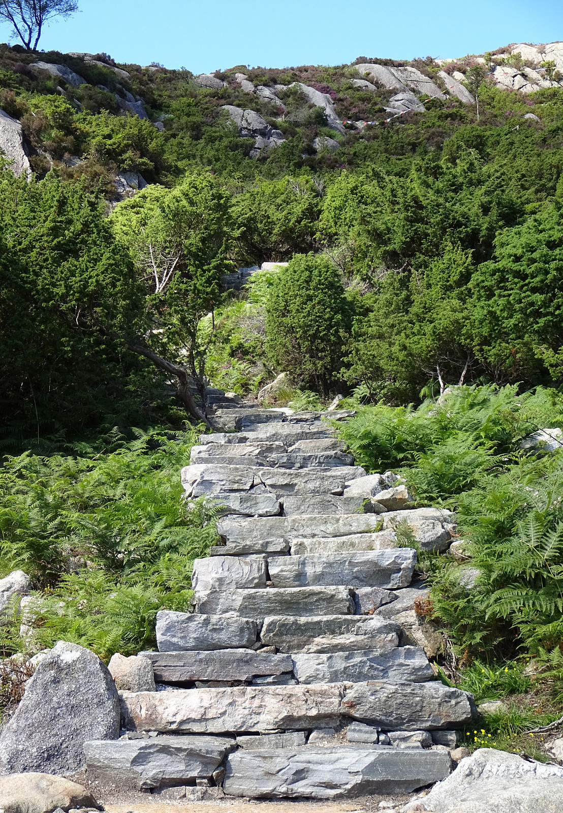 Before returning from Austevoll, we decided to include Kongsfjellet near Bekkjarvik. Passing by Bekkarvik church, we headed toward the starting point of Kongskleivo, i.e., the newly layed stone path up to Kongsfjellet. After first rounding Taushaugen in its east and south, we started with stepping up the big stone steps, ascending to the "top" of Taushaugen before continuing to Kongsfjellet. At Kongsfjellet, we enjoyed some nice views in all directions (mostly across Bekkjarvik and southwards). We then walked a bit across the ridge of Kongsfjellet before hurrying down the stone steps, again, in order to secure a relaxed drive back to the ferry in Hufthammar. All in all, Kongskleivo is, yes, impressive due to the big stones, while then, also, kind of boring. The views from Kongsfjellet, >>>
Vinnesvatnet and Veten
- Datum:
- 22.07.2020
- Tourcharakter:
- Bergtour
- Tourlänge:
- 2:00h
- Entfernung:
- 5,5km
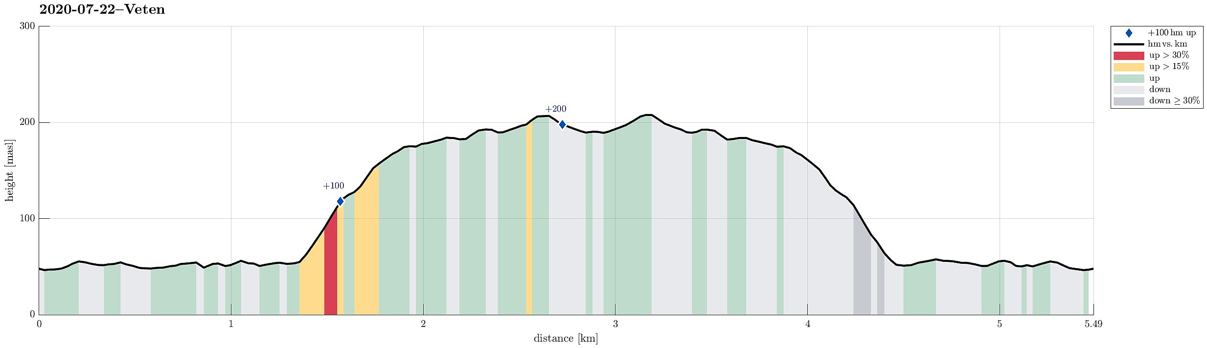 We took the ferry from Krokeide to Hufthammar and continued southwards from there, following the road into the direction of Husavik (road 546). After passing Husavik, we approached Vinnes, making a spontaneous decision to visit Vinnesvatnet from there. We parked near Hoppensprett kindergarten and started walking along a gravel path that leads very nicely around Vinnesvatnet. On the western side of Vinnesvatnet, we also visited the little island in Vinnesvatnet, walking across a nice little hanging bridge. At the northern end of Vinnesvatnet, where the gravel path deviates a bit from the lake, we started following a trail leading to Veten. After first ascending significantly, we then had a pleasant walk over the heights in the southeast of Veten. Eventually, we came to Veten, enjoying >>>
Loddo and Skaftafjellet
- Datum:
- 06.10.2018
- Tourcharakter:
- Bergtour
- Tourlänge:
- 4:30h
- Entfernung:
- 15,2km
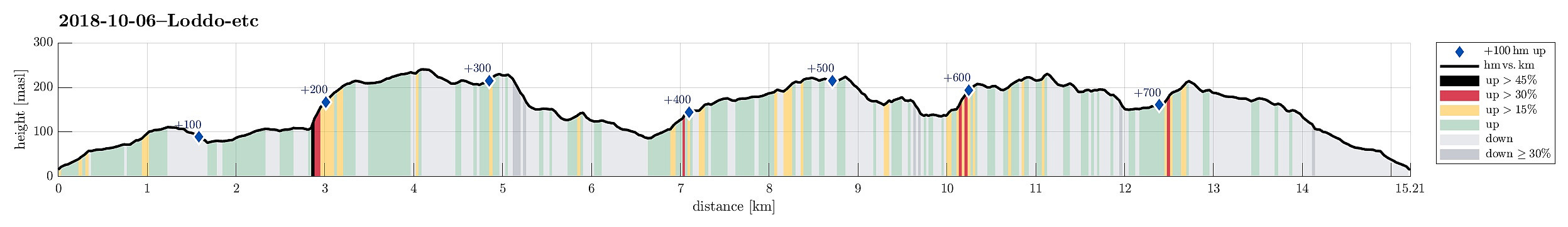 We took the ferry from Krokeide to Hufthammar and drove than along Huftarøy (road 154). Right next to Åkyllaren, there is a well-marked parking place for those, who wish to hike up to Loddo. We followed the main track (in southeastern direction) until we found a sign leading us on a separate track, heading north. Later, it turned out that we had left the main track too early and thus were a little bit too far west (as compared to the "red" track up to Loddo). Near Hestatjørna, we also managed to misinterpret another sign, which would have lead us back to the "red" track and up to Loddo. Instead, we followed the path further north, wondering more and more, where we had ended up! :-) After a while, we found another sign, which promised us a connection to the "blue" >>>
Skjenestølen
- Datum:
- 05.04.2015
- Tourcharakter:
- Spaziergang
- Tourlänge:
- 1:00h
- Entfernung:
- 2,3km
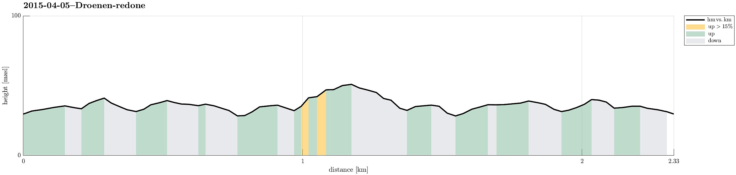 Starting from the last bus stop on Drønen, we walked along the island until we reached Skjenestølen, the highest spot on Drønen -- a short walk, but nice to get out and have some fresh air! :-)
