Arkiv - dato
Arkiv - aktivitet
-
Annen tur (1)
- Kajakkpadling (1)
-
Annen vintertur (4)
- Trugetur (4)
- Fottur (740)
-
Skitur (4)
- Fjellskitur (4)
-
Sykkeltur (137)
- Blandet sykling (51)
- Gatesykling (9)
Arkiv - Etter geografi
"Peakbookvenner"


Lister jeg samler etter
-
Bergen ≥ 50m pf. og ≥ 100 m.o.h.
(87/89)
 97%
97% -
Most dominating tops of the Bergen peninsula
(68/75)
90%
-
Utvalgte topper og turmål i Bergen
(316/350)
90%
-
Alle topper i Bergen
(357/398)
89%
-
Opptur Bergen
(100/113)
88%
-
De syv fjell rundt Bergen
(6/7)
85%
-
Sund ≥ 50m pf.
(14/18)
77%
-
Os ≥ 50m pf.
(25/34)
73%
-
Søyler (fastmerker) i Bergen
(68/100)
68%
-
Fjell ≥ 50m pf.
(21/32)
65%

Byrkjefjellet, Iendefjellet, and Skeisheia
- Dato:
- 02.08.2025
- Turtype:
- Fottur
- Turlengde:
- 7:00t
- Distanse:
- 16,5km
 We expected "one last nice day before the rain" and thus aimed at one more nice hike! :-) Without much hesitation, we agreed to make a hike to Iendefjellet, north of Kvamskogen. We took the car from Bergen to Kvamskogen and parked at the southern end of Tryglakleiv, right next to the "main road" across Kvamskogen (road #49). We then started to hike up road Tryglakleiv, aiming at the heights in the southwest of Tryglakleivtjørnane. All of this is easy to find and from "up there" (a bit below 600 masl), the real ascent towards Byrkjefjellet starts (then mostly in northern direction). Following a proper trail, we completed the (partially steep) ascent relatively quickly. It was, however, very hot and we recognized and respected the roughly 600 height meters >>>
Kjerringafjellet
- Dato:
- 03.10.2020
- Turtype:
- Fottur
- Turlengde:
- 4:30t
- Distanse:
- 10,8km
 We drove from Bergen to Bergsdalen (via Dale) and parked right where the road through Bergsdalen crosses from Vaksdal district to Voss district. On the southwestern side of the road, we stepped off the parking lot and on to a trail that leads into the direction of Øvretjørni, leading through a field of cabins there. Surrounding Øvretjørni in its northwest, the trail then turns more into a southward direction, aiming for the saddle between Magneknolten and Kjerringafjellet. Once in the west of Magneknolten, the trail surrounds Rjupehaugane in their south until it brings one into a small valley that extens upwards to Hardingskaret in its northwest. Before actually getting there (Hardingskaret), one turns left, again, and towards Kjerringafjellet. A steadily ascending slope leads up to >>>
Nessteinen from Mundheim
- Dato:
- 25.07.2020
- Turtype:
- Fottur
- Turlengde:
- 5:00t
- Distanse:
- 8,4km
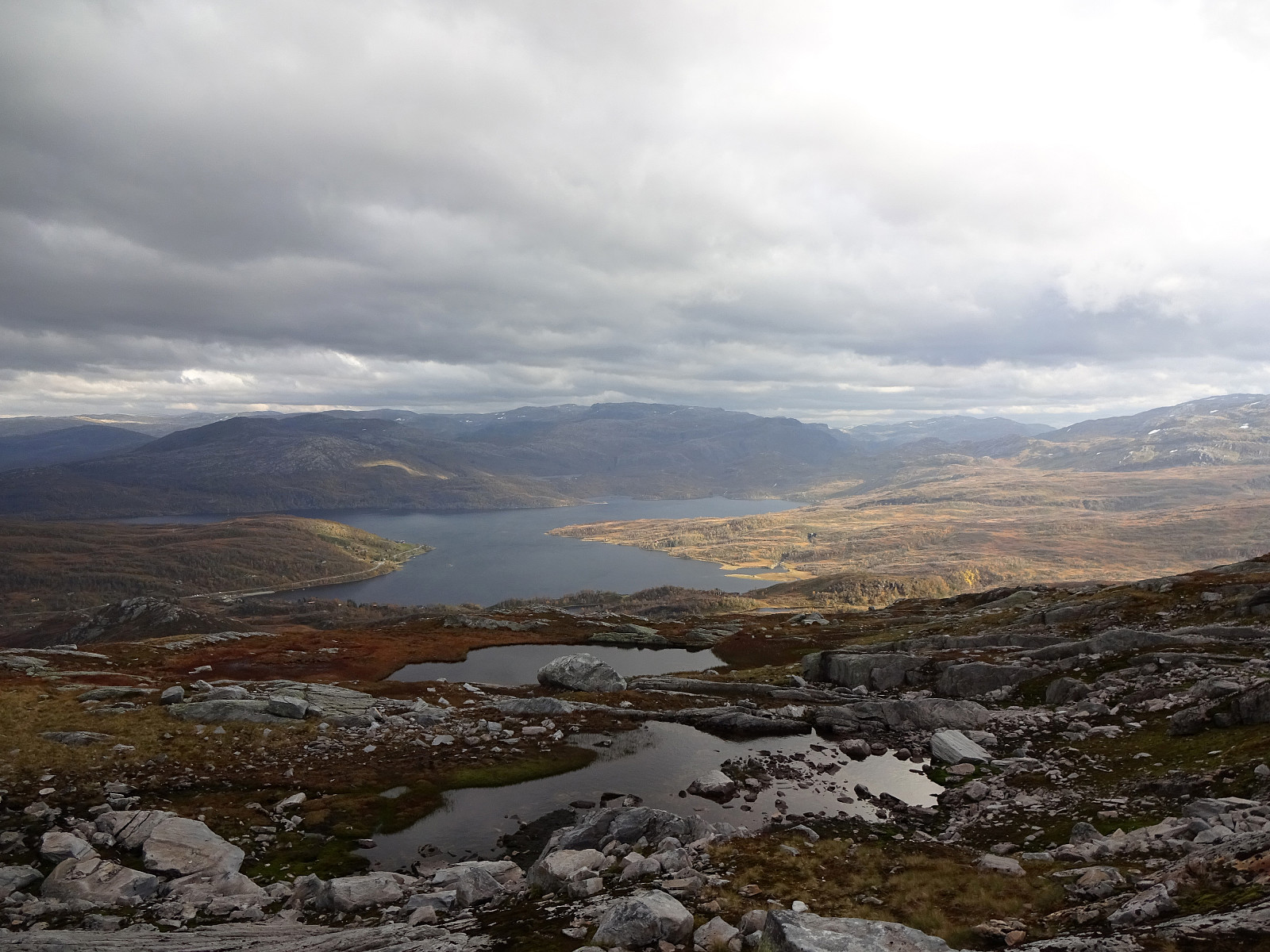
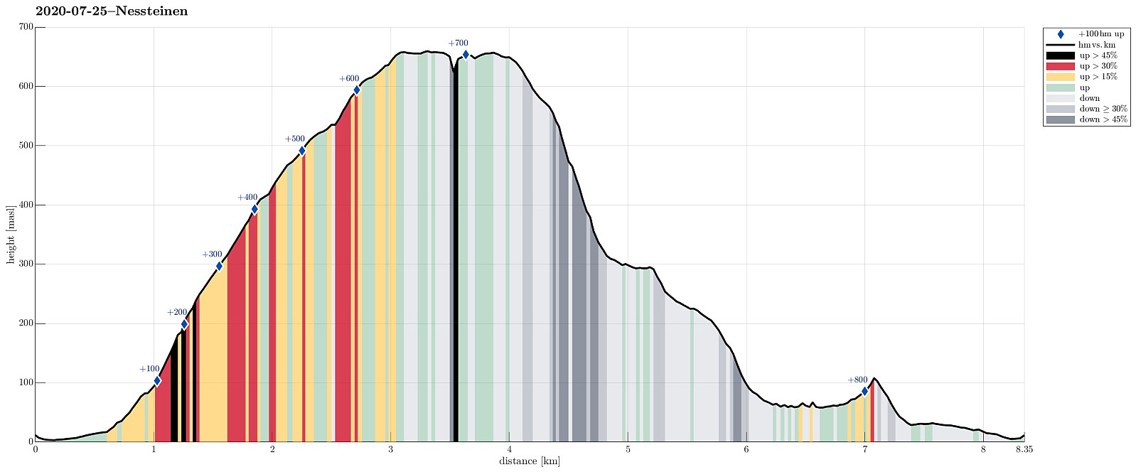 Having been "in the area", we decided to include a hike up to Nessteinen (or Steinen), expecting some nice views over Hardangerfjorden from up there. Another reason for choosing something not more extensive was the expectation of an overcast day with somewhat unstable weather. We drove the very nice road 49 from Norheimsund southwards (first around Visoldo to Strandebarm and then further southwards along Daurmålsegga to Mundheim). In Mundheim, we parked and started our hike first for a few meters northwards along road 48. At Oppheim, we crossed Storelva and walked up a simple field road to about 50mosl, where the field road meets the forest. From there, we continued along an not really used forest road, leading diagonally upwards (in eastern direction). At about 75mosl, however, >>>
Skrott and Breidablik from Fitjadalen
- Dato:
- 24.07.2020
- Turtype:
- Fottur
- Turlengde:
- 5:30t
- Distanse:
- 12,5km
 Expecting a nice summer day, we headed into the direction of Hardanger. Our plan was to ascend to Skrott, starting from Fitjadalen. After first driving to Øystese, via Kvamskogen, we turned into a northwards direction in Øystese, ascending east of Øysteseelva towards Fitjadalsvatnet. After rounding Fitjadalsvatnet on its eastern side, we parked at Fitjadalen and started hiking along the nicely marked trail leading up to Breidablik via Håsete and Vindskjersleitet. One first walks a bit "kind of" level until crossing Kjølo, coming down from Smørdalen, before then starting a significant ascent into the direction of Håsete. All in all, there isn't too much interesting to write about this trail, rather than that it's straight-forward to follow. At Håsete, we deviated for >>>
Tåkenuten and Kråkenos
- Dato:
- 23.05.2020
- Turtype:
- Fottur
- Turlengde:
- 6:15t
- Distanse:
- 13,4km
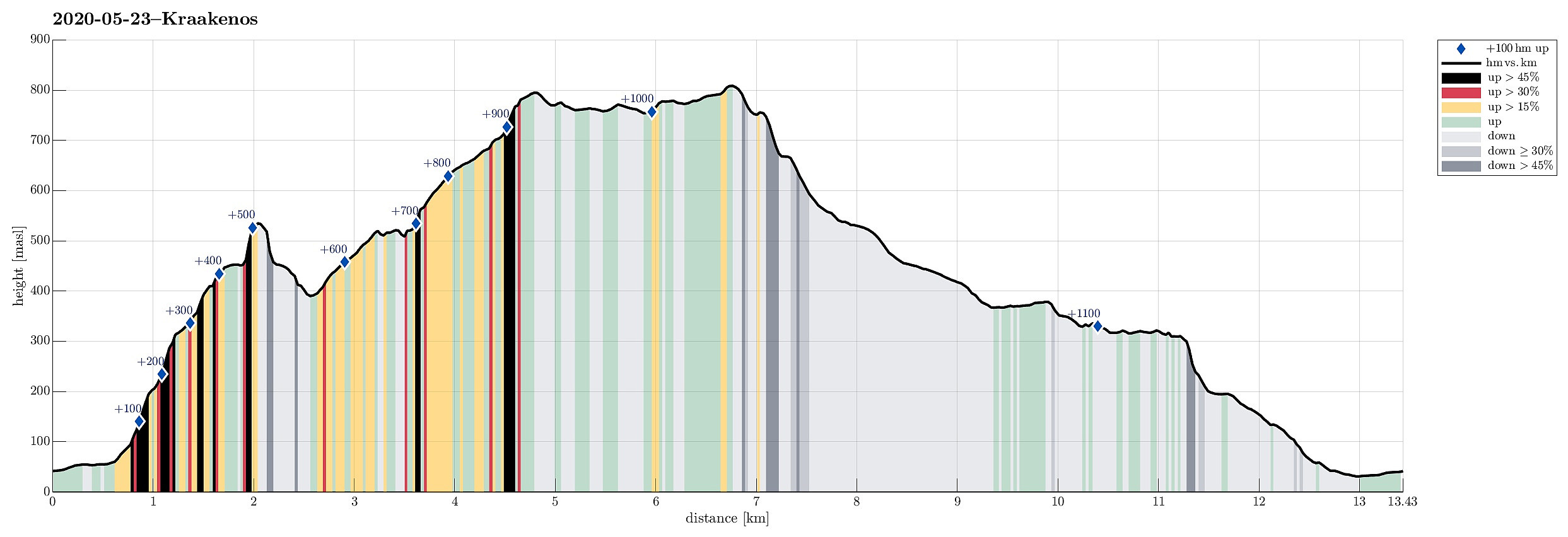 Weighing the weather forecast with our wish to make a nice hike, we ended up with Kråkenos as our hiking goal. While this mountain is also well accessible from its eastern side (from Bru near Strandebarm at Hardangerfjorden), we decided to approach it from its western side, i.e., from Øvre Hålandsdalen. To get there, we drove from Bergen first along E16 into the direction of Voss, then along road 49 into the direction of Kvamskogen, before then continuing along road 48 to Eikelandsosen and from there further towards Holdhus a few kilometers in the east of Eikelandsosen. Near Holdhus one needs to take a sharp turn to the left (north) onto an old and narrow road that leads into Øvre Hålandsdalen (after first passing between Gjønavatnet in the north and Skogseidvatnet in the south). >>>
Tveitakvitingen from Tveita
- Dato:
- 09.10.2016
- Turtype:
- Fjelltur
- Turlengde:
- 7:00t
- Distanse:
- 16,4km
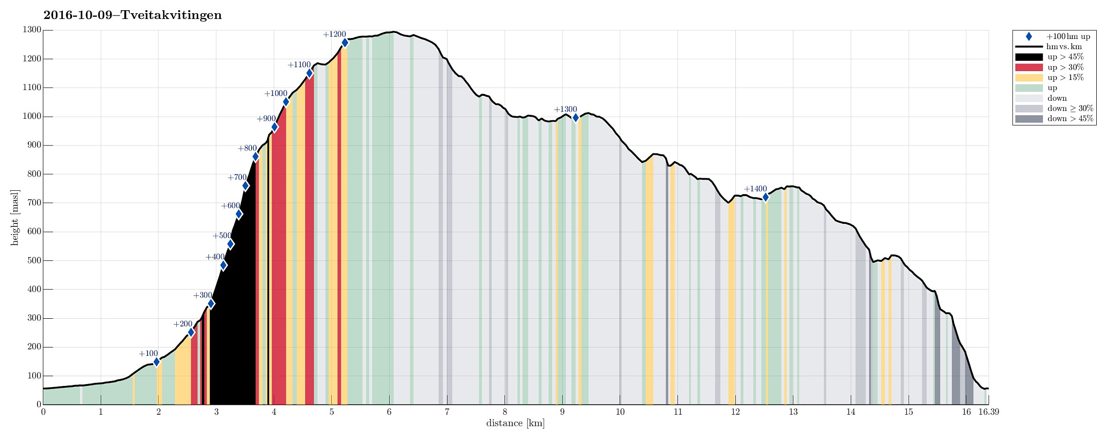 We took E16 from Bergen to Trengereid, then following road number 7 to Samnanger, before changing over to road number 48 right after Hagaåstunnelen. We passed through Eikelandsosen and continued to Holdhus, where we changed to a small road, which would lead us into the Tveita valley. Once there, we continued almost all the way in and parked near Bratthus, close to Indre Tveita. From there, we walked the rest of the road into the end of this nice valley, passing the last farm at Brekka soon after. The way continues into Tveitaskaret, where it becomes steep very soon (but easy to hike---mostly, because a gravel road has been constructed---probably to help maintaining a small power station that was opened in Tveitaskaret in 2009). At the end of the gravel road, one can further ascend through >>>
Tørviknuten and Visoldo
- Dato:
- 04.09.2016
- Turtype:
- Fjelltur
- Turlengde:
- 6:30t
- Distanse:
- 17,6km
 We took FV7 from Bergen towards Hardanger and turned right in Nordheimsund, following road 49 from there. We passed Tørvikbygd and when we had Eidesvatnet to our left, we entered a very small and narrow road, leading up to Åse. We parked a few meters above the farm and started to walk along a forrest road that extends further up from there. As we got higher on this forrest road, we started to pay attention to where a suitable path would take off (to the left and up). When passed Åsstølen (on the right), we started to be particularly curious, but still no inviting opportunity appeared on our left-hand side. Eventually, we decided to walk all the forrest road up (and over a small saddle right west of Hågeli), leading towards a place, where they obivously deal with some sheep, or the >>>
Oksen
- Dato:
- 15.05.2016
- Turtype:
- Fjelltur
- Turlengde:
- 5:00t
- Distanse:
- 9,3km
 We drove the beautiful road no. 7 into Hardangerfjorden. At Granvin, we connected to the road that comes down from Voss, turning right (into the direction of the new Hardanger-bridge and Ulvik, etc.). We passed the long tunnel (about 8 km), continued towards Ulvik (not up to the bridge) and turned right into a small road right after the tunnel (this place is not completely obvious and paying a little extra attention right after the tunnel helps). From there, we drove (in a way back ) all the way out to the tip of the peninsula on which Oksen is the last mountain. The end of the road (and the starting point for hiking) is Tjoflot. There, one can drive a bit up (passing the farms there) and find a parking spot right after entering the forrest. From there (at about 230 meters over the sea >>>
