Archiv - Nach Datum
Archiv - Nach Aktivität
-
Andere Tour (1)
- Kayaking (1)
-
Andere Wintertour (4)
- Schneeschuhtour (4)
-
Fahrradtour (137)
- Fahrradtour Straße (9)
- Fahrradtour gemischt (51)
-
Fußtour (740)
- Bergtour (363)
- Jogging (18)
- Spaziergang (89)
- Wanderung (270)
-
Skitour (4)
- Tourenskilauf (4)
Archiv - Nach Geografie
Peakbookfreunde


Gesammelte Listen
-
Bergen ≥ 50m pf. og ≥ 100 m.o.h.
(87/89)
 97%
97% -
Most dominating tops of the Bergen peninsula
(68/75)
90%
-
Utvalgte topper og turmål i Bergen
(316/350)
90%
-
Alle topper i Bergen
(357/398)
89%
-
Opptur Bergen
(100/113)
88%
-
De syv fjell rundt Bergen
(6/7)
85%
-
Sund ≥ 50m pf.
(14/18)
77%
-
Os ≥ 50m pf.
(25/34)
73%
-
Søyler (fastmerker) i Bergen
(68/100)
68%
-
Fjell ≥ 50m pf.
(21/32)
65%

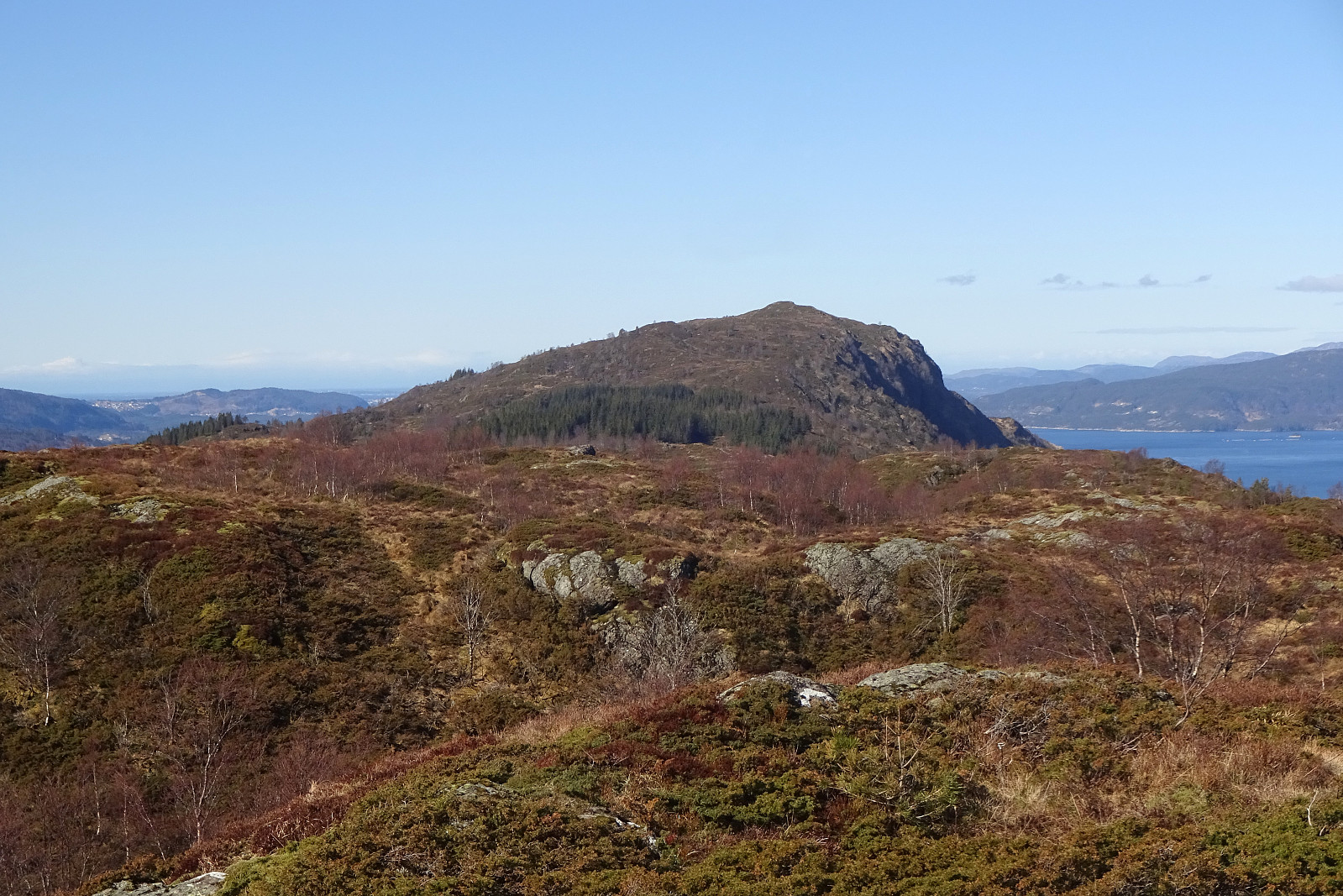
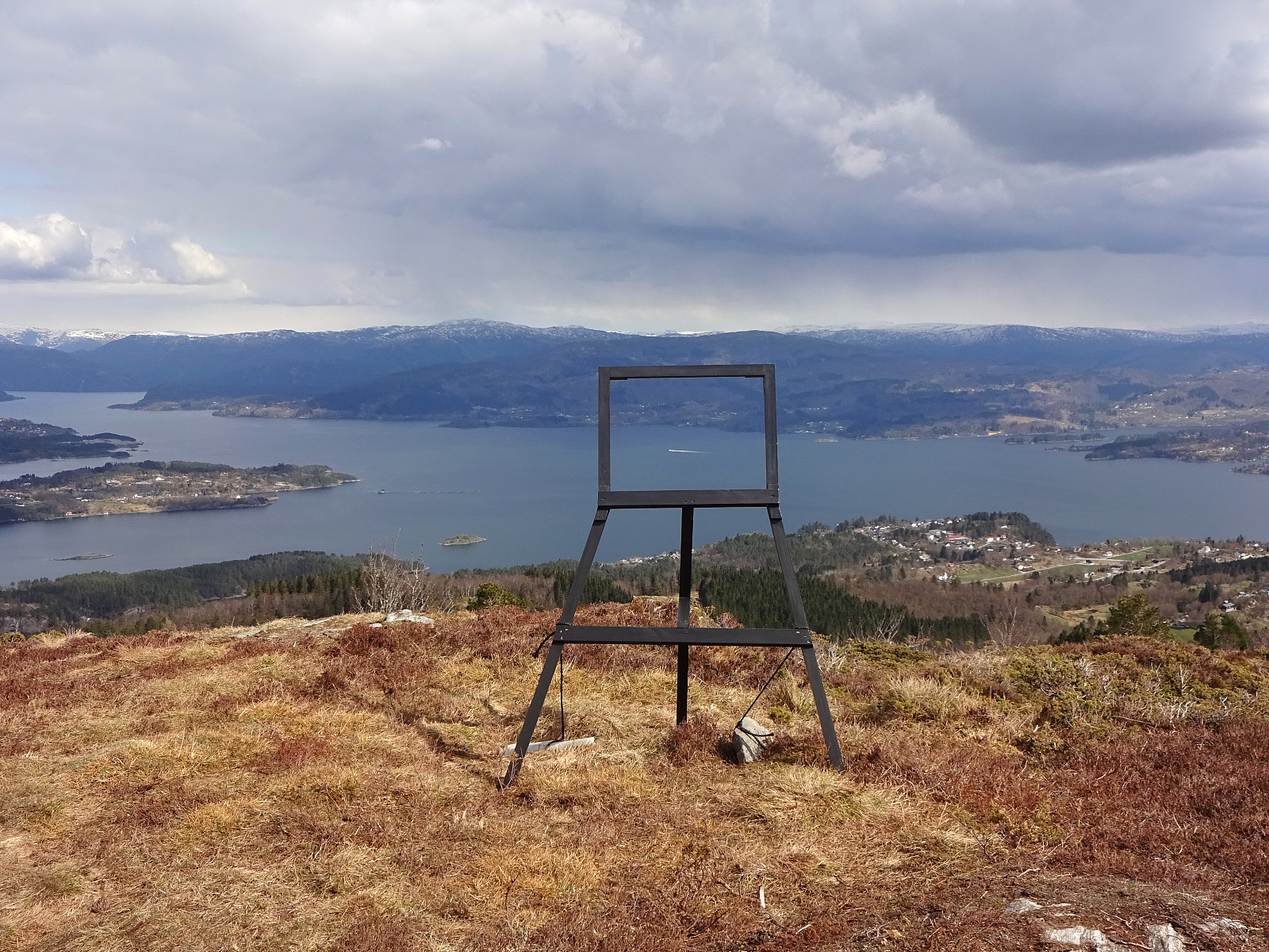
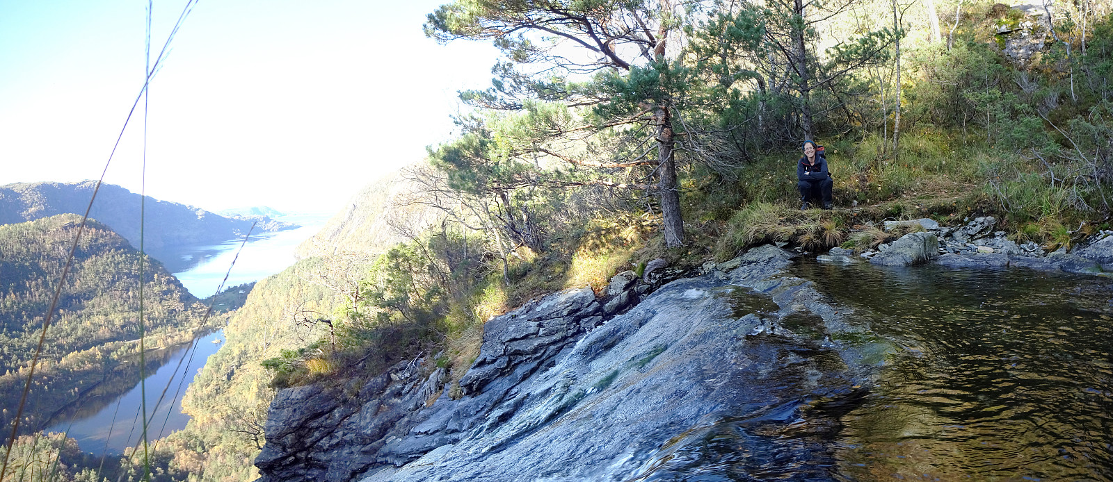
Vassberget, Kvamsfjellet, and Tveitavarden
- Datum:
- 28.02.2026
- Tourcharakter:
- Wanderung
- Tourlänge:
- 4:00h
- Entfernung:
- 10,0km
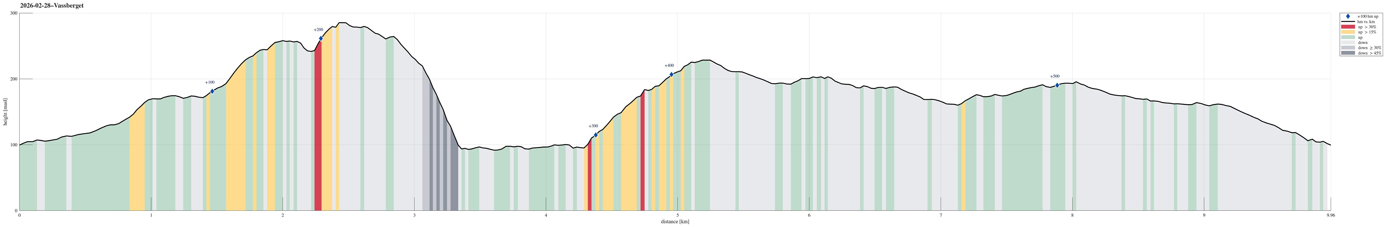 We expected a nice day and wished to make a nice, moderate hike with a chance to catch some sun, also. After first looking at Tveitavarden, Kvamsfjellet, and Vassberget, north of Knarvik, we then found a description of a hike over these hills, but in reverse order, providing additional motivation to explore this part of Alver. After driving there from Bergen, we parked right next to Lindåsvegen, where Årdalen comes down from the northwest. Walking up Årdalen, we then found the trail head for Vassberget, which is nicely marked with a sign. Following this trail, we quickly made it up the ridge in the southwest of Kråkstidalen, but instead of crossing over this valley (as the main trail does), we continued further northwards on the ridge (into the direction of Litlevassberget). At times and with some phantasy, >>>
Djupedalseggene and Vindeggene from Ostereidet
- Datum:
- 24.03.2024
- Tourcharakter:
- Wanderung
- Tourlänge:
- 5:00h
- Entfernung:
- 16,4km
 We took the car from Bergen, first following E39 via Knarvik. From Osterfjordvegen, we then took a small road to Ostereidet, where we parked next to the local school. We started our hike up to Hovåsen, following first some forest roads and then a trail along the southeastern ridge of Hovåsen. From there, we then crossed over to the gravel road that leads up to Storset (via Bruarinden). After then walking up this gravel road to the end of the road at Storset, we then followed a marker that directed us to a small ridge in the south of Storsettjørna (and west of Vardhaugen). Crossing over this ridge (in northwestern direction) and stepping over the small stream that comes down from Storsettjørna (in southwestern direction), we ended up on the trail up to Vindeggene (this trail is not >>>
Gladihaug and Krossane from Votno
- Datum:
- 01.05.2021
- Tourcharakter:
- Wanderung
- Tourlänge:
- 4:00h
- Entfernung:
- 13,5km
 For a while, we had contemplated to hike Gladihaug one day. This morning, we decided to finally do it! :-) We took the car to the north of Bergen, driving along E39 towards Knarvik. Once there, we turned left in Knarvik and continued along road 57 (into the direction of Mongstad in the north of Knarvik). After driving through Espelandstunnelen and Herlandstunnelen on Lindåsvegen, we parked right next to the road (where one also could drive off to Seim only a bit further in the north). We then started our hike towards Gladihaug by walking into Votno, approaching the significant ridge of Hellefjellet from its north. As soon as we found ourselves on this ridge (in the south of Votno), we also had found a simple trail that was easy to follow. At about 250mosl, this trail even got "upgraded" >>>
Austlendingen
- Datum:
- 11.10.2020
- Tourcharakter:
- Wanderung
- Tourlänge:
- 4:30h
- Entfernung:
- 8,7km
 We left Bergen on E39 towards the north (Knarvik) and continued further on E39 in northeastern direction (north of Osterfjorden) after having past Knarvik. Right before we would have entered the long Eikefettunnelen, we turned left (onto road 570) and parked only meters after leaving road E39. Our main goal of the day was Austlendingen and we had thought to start along the main trail there, which starts just meters west of the entry to Eikefettunnelen (on the southern side of road E39). Our plan, as prepared at home, was to attempt a round (off trail up, on the main trail down), but when we came to the trail head, we encoutered a pretty bold sign informing everyone about the ongoing hunting period and that hikers should stay on marked trails. After a little bit of consideration, we decided >>>
Husdalsfjellet via Husdalen from Kanalen
- Datum:
- 13.04.2019
- Tourcharakter:
- Bergtour
- Tourlänge:
- 5:00h
- Entfernung:
- 13,3km
 We took the E39 to the north of Bergen, crossing over to Knarvik over Nordhordlandsbrua. We then continued along E39 (in the direction of Førde) along the northern side of Osterfjorden. Right after Bjørsviktunnelen, we turned right at the second opportunity (marked towards Molvik there). Note that this exit comes almost immediately after the one to Bjørsviki, so it's good to keep your eyes open right after leaving the tunnel! :-) We then followed Molvikavegen for only a very short stretch until we crossed over the little bridge over Kanalen. Right after the bridge, we found a little place on the left, where we could park for a while. Just meters above the parking, a private road to Husdalen leaves to the northeast (left), locked behind a bar. We hiked along this road then, in the >>>
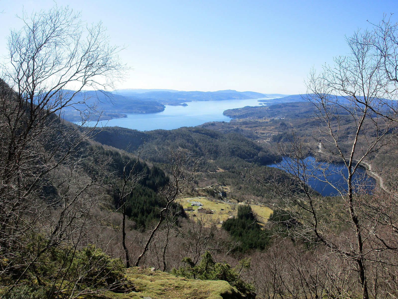
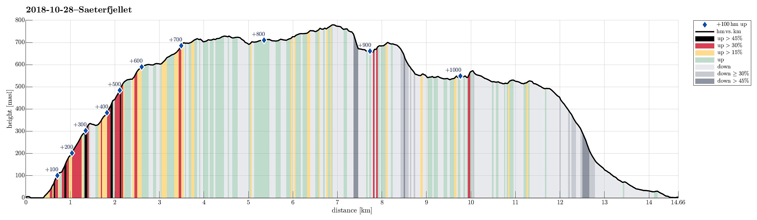
Sæterfjellet on a wonderful winter day
- Datum:
- 28.10.2018
- Tourcharakter:
- Bergtour
- Tourlänge:
- 7:00h
- Entfernung:
- 14,7km
 We drove from Bergen northwards on E39, continuing further in the direction of Førde after Knarvik. Right before entering Eikefettunnelen, we left E39 and continued on road 570 in northern direction. After coming by Dyrdalen, we soon reached Kjekallevågen and bridge over it. Right afterwards, on Borgaholmane, we parked and started our hike.
To start, we first crossed the bridge again (now per pedes and in southern direction) and headed towards Langeneset. At exactly the point, where the bridge ends, we left the road and started our ascent to Såta, stepping up a long ridge (south of Rasmusdalen), leading up to Gamlesetra, etc. The first check-point along this route is a point at about 115mosl, where the power line, which comes southwards across Kjekallevågen, makes a turn so that it >>>
We drove from Bergen northwards on E39, continuing further in the direction of Førde after Knarvik. Right before entering Eikefettunnelen, we left E39 and continued on road 570 in northern direction. After coming by Dyrdalen, we soon reached Kjekallevågen and bridge over it. Right afterwards, on Borgaholmane, we parked and started our hike.
To start, we first crossed the bridge again (now per pedes and in southern direction) and headed towards Langeneset. At exactly the point, where the bridge ends, we left the road and started our ascent to Såta, stepping up a long ridge (south of Rasmusdalen), leading up to Gamlesetra, etc. The first check-point along this route is a point at about 115mosl, where the power line, which comes southwards across Kjekallevågen, makes a turn so that it >>>
