Arkiv - dato
Arkiv - aktivitet
-
Annen tur (1)
- Kajakkpadling (1)
-
Annen vintertur (4)
- Trugetur (4)
- Fottur (740)
-
Skitur (4)
- Fjellskitur (4)
-
Sykkeltur (137)
- Blandet sykling (51)
- Gatesykling (9)
Arkiv - Etter geografi
"Peakbookvenner"


Lister jeg samler etter
-
Bergen ≥ 50m pf. og ≥ 100 m.o.h.
(87/89)
 97%
97% -
Most dominating tops of the Bergen peninsula
(68/75)
90%
-
Utvalgte topper og turmål i Bergen
(316/350)
90%
-
Alle topper i Bergen
(357/398)
89%
-
Opptur Bergen
(100/113)
88%
-
De syv fjell rundt Bergen
(6/7)
85%
-
Sund ≥ 50m pf.
(14/18)
77%
-
Os ≥ 50m pf.
(25/34)
73%
-
Søyler (fastmerker) i Bergen
(68/100)
68%
-
Fjell ≥ 50m pf.
(21/32)
65%

Skiing Bildøybakken
- Dato:
- 14.02.2026
- Turtype:
- Fjellskitur
- Turlengde:
- 2:00t
- Distanse:
- 5,2km
 With new snow outside, we decided to take our skies and head towards Bildøybakken for an excursion into the snow. We parked at the lower end of the road which leads up to the dam of Bildøyvatnet, then following this road up to the dam. From there, we then ascended to Bildøyfjellet. Then, we continued across the heights of Bildøybakken (southwards to Vardafjellet). We then decided to connect to the southern end of Bildøyvatnet in order to cross it (on skies) south-to-north. This worked just fine and it did not take us all to long before we were back where we had started the afternoon.
Selected photos are available as Google photo album .
See also the related FB-page Hiking around Bergen, Norway .
With new snow outside, we decided to take our skies and head towards Bildøybakken for an excursion into the snow. We parked at the lower end of the road which leads up to the dam of Bildøyvatnet, then following this road up to the dam. From there, we then ascended to Bildøyfjellet. Then, we continued across the heights of Bildøybakken (southwards to Vardafjellet). We then decided to connect to the southern end of Bildøyvatnet in order to cross it (on skies) south-to-north. This worked just fine and it did not take us all to long before we were back where we had started the afternoon.
Selected photos are available as Google photo album .
See also the related FB-page Hiking around Bergen, Norway .
Liatårnet from Fjellavegen via Fjellasåta
- Dato:
- 12.10.2025
- Turtype:
- Fottur
- Turlengde:
- 4:00t
- Distanse:
- 7,4km
 We parked south of Fjell along Søre Fjellavegen and started our hike by aiming at Fjellasåta via Rindane. Basically at the saddle, where Søre Fjellavegen starts to descend again towards the south, we found a very basic trail (or something like that), which brought us well up and onto Rindane (towards the east). Even though this trail (or "trail") was not always immediately obvious, we still made it quickly and easily to Fjellasåta (Kannikahaugen). From there, and instead of following the north-south oriented trail across Fjellasåta, we proceeded further eastwards (towards the southern end of Gyravatnet). When down at Festningsvegen, we did not have to search long before we found a little opening in the thick valley forest. This opening connected to a simple "trail" >>>
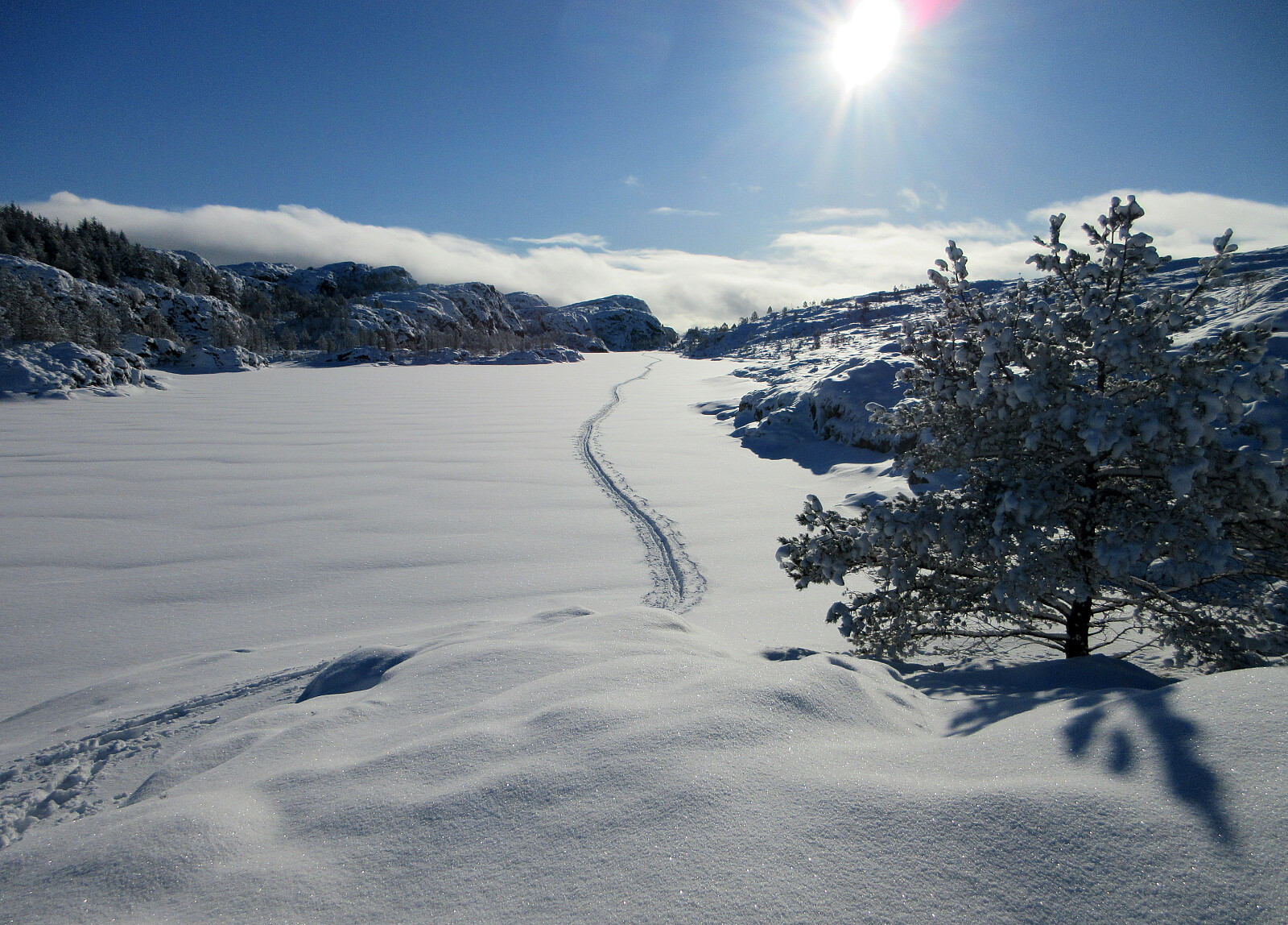
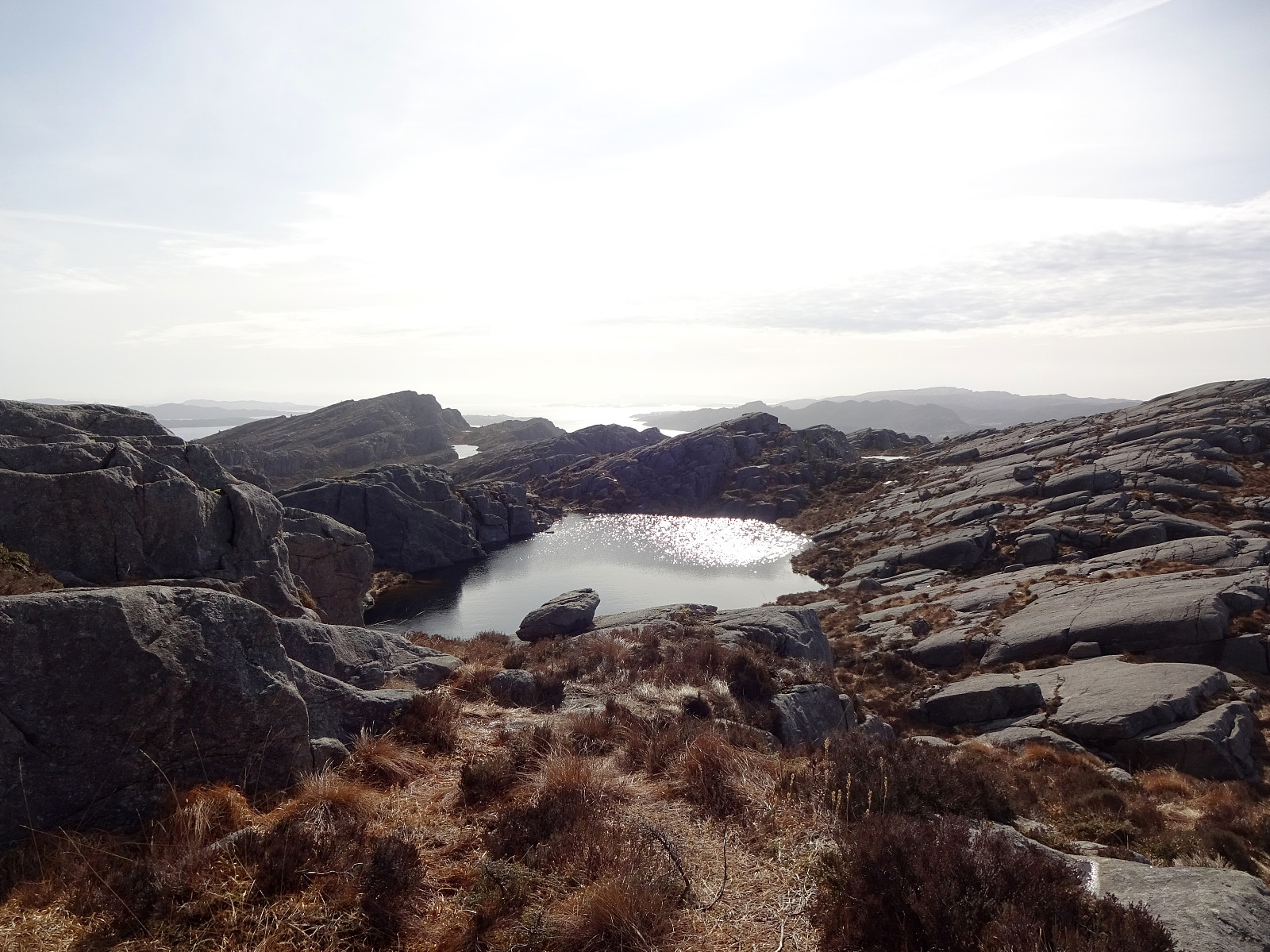
Kannikahaugen from Bildøybakken
- Dato:
- 15.02.2025
- Turtype:
- Fottur
- Turlengde:
- 5:00t
- Distanse:
- 12,0km
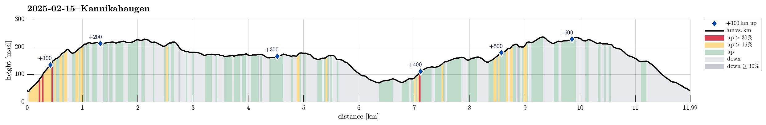 With a really nice weather forecast, we just wished to use the good weather for a nice walk. The idea was to start at Bildøyfjellet, north of Liatårnet on Sotra, and then hike a (squished) round from there (without any plan to actually ascend to Pyttane nor Liatårnet). We parked right next to Bildøybakken, not far from the corner, where one can also drive to Liaskjeret. Instead of using the access road towards the dam of Bildøyvatnet, we aimed at Bildøyfjellet directly (and without a trail). Given the below freezing temperatures, we found the conditions just right for such an off-trail ascent. Within not too long, we then arrived at Bildøykletten (and at the trail, there). We then followed the trail southwards (via Steinane and Vardafjellet). Before descending to Fjellfestningen, >>>
Kyrkjenibben etc.
- Dato:
- 23.12.2024
- Turtype:
- Fottur
- Turlengde:
- 3:00t
- Distanse:
- 8,4km
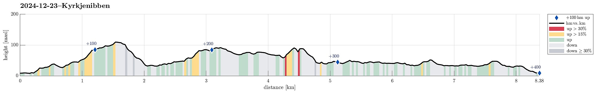 We expected the higher tops to be covered with clouds and thus decided to instead head towards the coast for a simple hike. We knew that one should be able to find a historic connection between Morland and Fjell, kyrkjevegen, which apparently was used by the people of Morland to get to the church in Fjell previously. We started near the church in Fjell and followed kyrkjevegen until we came to the south end of Eidesvatnet. Instead of following kyrkjevegen further northwards from there, we had already decided that we wished to include a detour to Gardafjellet a bit further west. Following a trail around Kvernhaugen (around the south of Liavatnet) brought us to the trail up to Gardafjellet (in northwestern direction). At Gardafjellet we enjoyed some nice views, before continuing -- then >>>
Sauafjellet and Spjeldsfjellet
- Dato:
- 25.03.2024
- Turtype:
- Fottur
- Turlengde:
- 3:30t
- Distanse:
- 9,9km
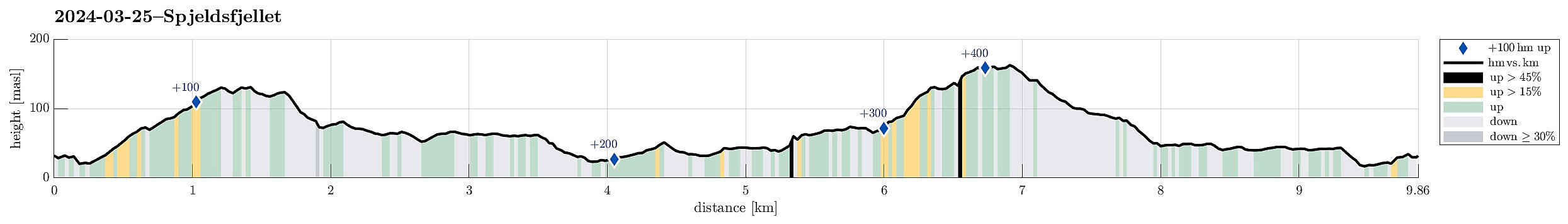 We started at Fjæreide and first went up Sauafjellet. From there, we then reconnected with the trail to Kårtveit north of Sauafjellet (descending Sauafjellet northwards without a trail was just fine; only the last few meters were a bit so that one had to find a way of where to go). We then followed the trail into the direction of Kårtveit, passing by Vardavatnet along the way. At Kårtveit, we wished to continue on another trail (to Spjeldsfjellet, a bit further north). We did not see a more straight-forward way then to first step out and onto road 5242, then follow this road northwards for some 200-300 meters, before then turning right and onto the planned trail, again. To pass by Urafjellet in its north (as planned), we needed to find the right "turn left" where also the >>>
Ørnafjellet and Austre Høghaugen
- Dato:
- 17.02.2024
- Turtype:
- Fottur
- Turlengde:
- 3:30t
- Distanse:
- 7,9km
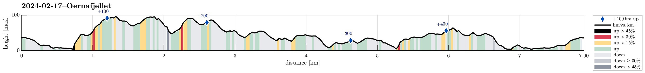 We expected some nice sun and decided to enjoy the day with an exploration of a part of Sotra that we had not visited before. We drove the car to Sotra and there to Fjell. South of Fjell, along Søre Fjellavegen and right next to Gardstjørna, we parked next to the road and started our hike, walking down a simple road towards Fjellspollen. Still on this road, we conveniently crossed over the waters, that spring down from Bosvatnet to Litlepollen, using the road-bridge. Studying the map at home had suggested that starting our ascent up to Ørnafjellet would be possible right from the road in the north of Litlepollen. Once there, however, we saw that the hill-side appeared a bit steeper than originally expected. Still, we could make it up to the heights in the north of Litlepollen without >>>
Pyttane in windy weather
- Dato:
- 03.02.2024
- Turtype:
- Fjelltur
- Turlengde:
- 1:30t
- Distanse:
- 6,7km
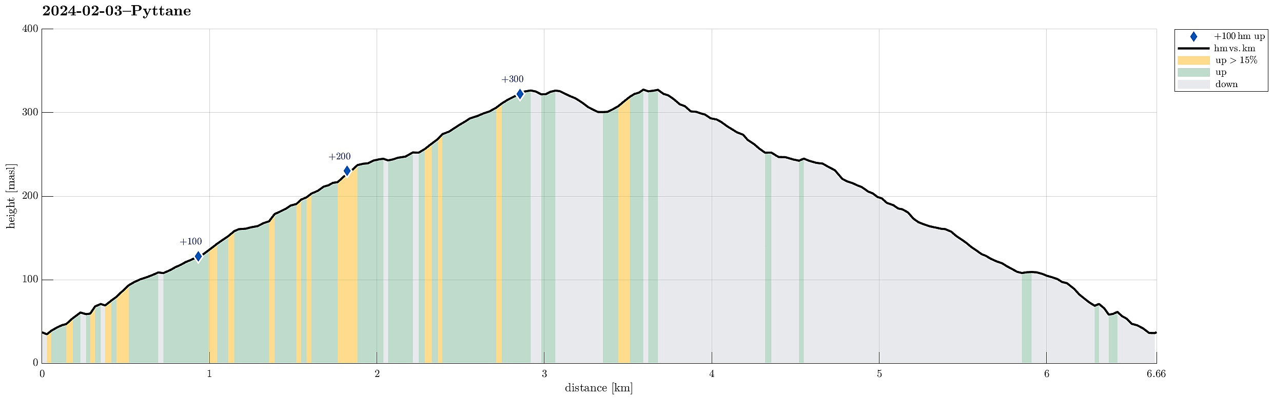 With quite a bit of weather outside, we decided to "just" go up and down Pyttane on Sotra. We took the car to Ekrhovdvegen in the very east of Sotra and parked near Nordre Stølen, where the service road up to Pyttane starts. We then walked up to the radar stations, experiencing significant weather on the top (strong winds, some precipitation). While it was nice to get out into the fresh air, we still did not feel like staying up there "in the elements" for any prolonged time, thus walking back down more or less immediately, again. All in all, this walk up to Pyttane is always nice (and easy), lending itself well to getting some fresh air without an all-too-long trip.
Selected photos are available as Google photo album .
See also the related FB-page Hiking around Bergen, Norway .
Web page WestCoastPeaks.com provides useful information about Liatårnet
and also Petter Bjørstad has a >>>
With quite a bit of weather outside, we decided to "just" go up and down Pyttane on Sotra. We took the car to Ekrhovdvegen in the very east of Sotra and parked near Nordre Stølen, where the service road up to Pyttane starts. We then walked up to the radar stations, experiencing significant weather on the top (strong winds, some precipitation). While it was nice to get out into the fresh air, we still did not feel like staying up there "in the elements" for any prolonged time, thus walking back down more or less immediately, again. All in all, this walk up to Pyttane is always nice (and easy), lending itself well to getting some fresh air without an all-too-long trip.
Selected photos are available as Google photo album .
See also the related FB-page Hiking around Bergen, Norway .
Web page WestCoastPeaks.com provides useful information about Liatårnet
and also Petter Bjørstad has a >>>
Liatårnet from Liaskjeret
- Dato:
- 11.08.2023
- Turtype:
- Fottur
- Turlengde:
- 4:30t
- Distanse:
- 9,1km
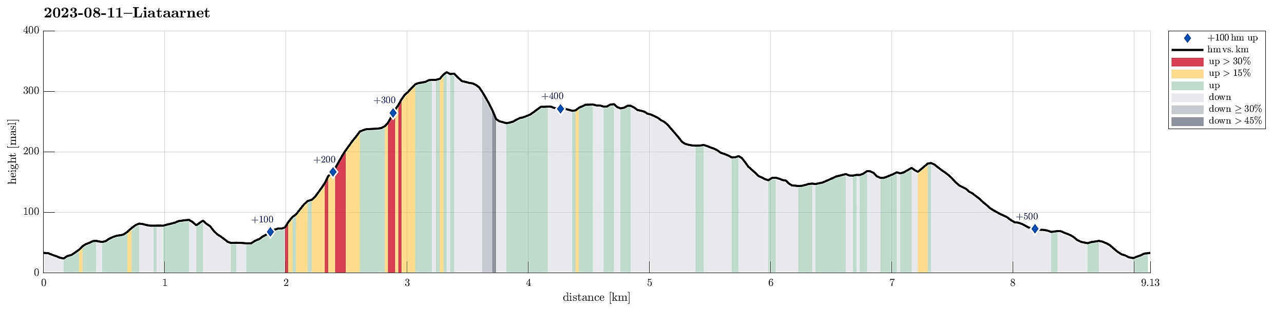 We took the car from Bergen towards the west, crossing over Sotrabrua. In the west of Bildøya, we turned south (onto Døsjevegen), driving to Liaskjeret in the east of Liatårnet. From Liaskjærshallen, we then started our hike with our first goal being the trail that leads up to Liatårnet from Hølo. To get there, we had the choice between walking along Liaskjervegen for a good stretch and the alternative of following a simple trail above (in the west) of the houses. Choosing the latter, we first walked up Elvabakkvegen to get to the nearest trail head near house #11. A few hundred meters further west (and up a little), we then turned right (northwards), aiming for Skoradalen via a simple trail. West of Skogsbrekko, however, we did not really find a good way to continue further to >>>
Liatårnet and Haganesfjellet from Liaskjeret
- Dato:
- 23.04.2022
- Turtype:
- Fottur
- Turlengde:
- 3:30t
- Distanse:
- 8,8km
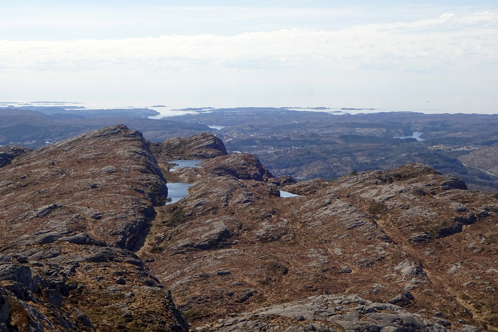 Liatårnet and Haganesfjellet from Liaskjeret. We parked next to Liaskjershallen in the southeast of Liatårnet on Sotra and walked first back (northwards) along Liaskjervegen until we found the spot where one can ascend to Dansarhaugen (just a few steps above the last houses on the hillside up to Liatårnet). We then crossed Skoradalen, mostly in northern direction, before we changed course after crossing over Bukkhelleren into a more northwestern direction, ascending rather straight up towards Liatårnet. Once on Liatårnet, we started our traverse across the heights south of Liatårnet, mostly in southern direction. South of Høgafjellet, we then came to Kattatjørna. This time, we passed by this lake on its eastern side, also stepping over Kattafjellet. It then was just straight southwards, >>>
Høgafjellet and Haganesfjellet from Buabrekko
- Dato:
- 26.03.2022
- Turtype:
- Fottur
- Turlengde:
- 3:00t
- Distanse:
- 8,6km
 Høgafjellet and Haganesfjellet from Buabrekko. We parked near Tellnesvegen and walked down Buabrekko, crossing over the stream down from Kvernavatnet where it enters Pollen at its very northern end. On the other, eastern side, a trail leads up to the northern end of Ravnafjellet. Originally, we had planned to find a minor trail that should have forked off somewhere half way up in northeastern direction. Since we had not found this trail, we quickly found ourselves at the northern end of Ravnafjellet. There, we left the trail and continued through some relatively wet terrain northwards. Basically right west of Varden, we then found a good spot for ascending to the "next level", north of Vedatåna. There, we then also connected to a trail that circles Varden in its west. After >>>
