Archive - Date
Archive - Activity
-
Bike trip (137)
- Bike trip - mixed (51)
- Bike trip - road (9)
-
Other trip (1)
- Kayaking (1)
-
Other winter trip (4)
- Snowshoe trip (4)
- Ski trip (4)
- Trip by foot (740)
Archive - Geography
Peakbook-Friends


Collected lists
-
Bergen ≥ 50m pf. og ≥ 100 m.o.h.
(87/89)
 97%
97% -
Most dominating tops of the Bergen peninsula
(68/75)
90%
-
Utvalgte topper og turmål i Bergen
(316/350)
90%
-
Alle topper i Bergen
(357/398)
89%
-
Opptur Bergen
(100/113)
88%
-
De syv fjell rundt Bergen
(6/7)
85%
-
Sund ≥ 50m pf.
(14/18)
77%
-
Os ≥ 50m pf.
(25/34)
73%
-
Søyler (fastmerker) i Bergen
(68/100)
68%
-
Fjell ≥ 50m pf.
(21/32)
65%

Stendafjellet at about sunset
- Date:
- 17.11.2018
- Characteristic:
- Hillwalk
- Duration:
- 1:00h
- Distance:
- 3.4km
 Even though it was already a bit late (for November in Bergen), there still was a chance for a short hike. From the little parking place near the previous train station at Stend (a bit north of Fana), I headed directly into the forest (in northern direction), not following the gravel road that also starts from there (a bit further east). After only a few steps, I got to a little pond (seemingly hold back by a little dam) and chose to surround it on its western side. In order to get further up, I crossed a little saddle north of the pond and ascended through the forest in northeastern direction, following one of apparently several possible routes. Once a bit further up, the terrain flattened out (a bit) and I continued in northern direction, heading towards Stendaåsen. After reaching the >>>
Løvstakken for some fresh air
- Date:
- 04.11.2018
- Characteristic:
- Hillwalk
- Duration:
- 1:00h
- Distance:
- 3.1km
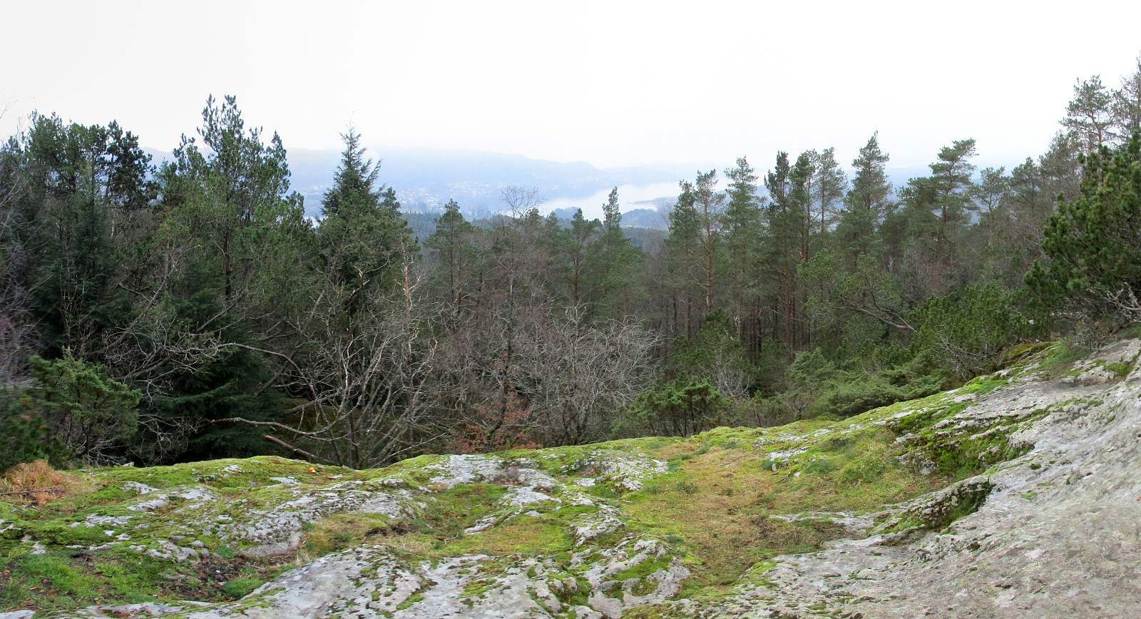
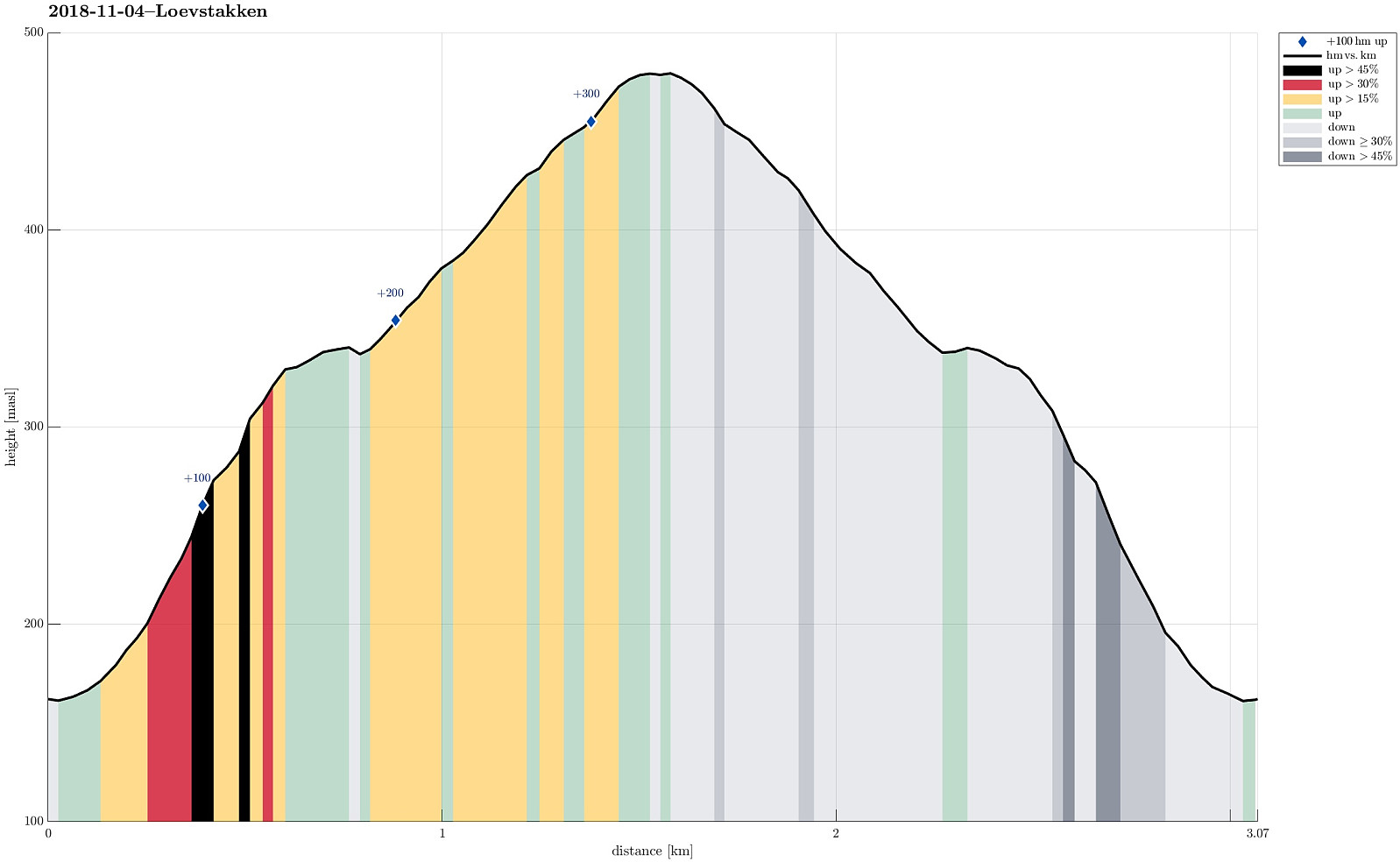 Due to a lack of more time, we this time "only" made a quick hike up Løvstakken. We parked right next to Litlavatnet in Fyllingsdalen and ascended via the main path to Løvstakken from there (first towards Ravnefjellet, then around and up to Løvstakken). After a short stop at the top (in strong winds!), we returned along the same path. Always good to at least get a bit of fresh air! :-)
Selected photos are available as Google photo album .
See also the related FB-page Hiking around Bergen, Norway .
Web page WestCoastPeaks.com provides useful information about Løvstakken .
Due to a lack of more time, we this time "only" made a quick hike up Løvstakken. We parked right next to Litlavatnet in Fyllingsdalen and ascended via the main path to Løvstakken from there (first towards Ravnefjellet, then around and up to Løvstakken). After a short stop at the top (in strong winds!), we returned along the same path. Always good to at least get a bit of fresh air! :-)
Selected photos are available as Google photo album .
See also the related FB-page Hiking around Bergen, Norway .
Web page WestCoastPeaks.com provides useful information about Løvstakken .
Vemånen, Hovden, etc.
- Date:
- 30.09.2018
- Characteristic:
- Hillwalk
- Duration:
- 2:30h
- Distance:
- 7.4km
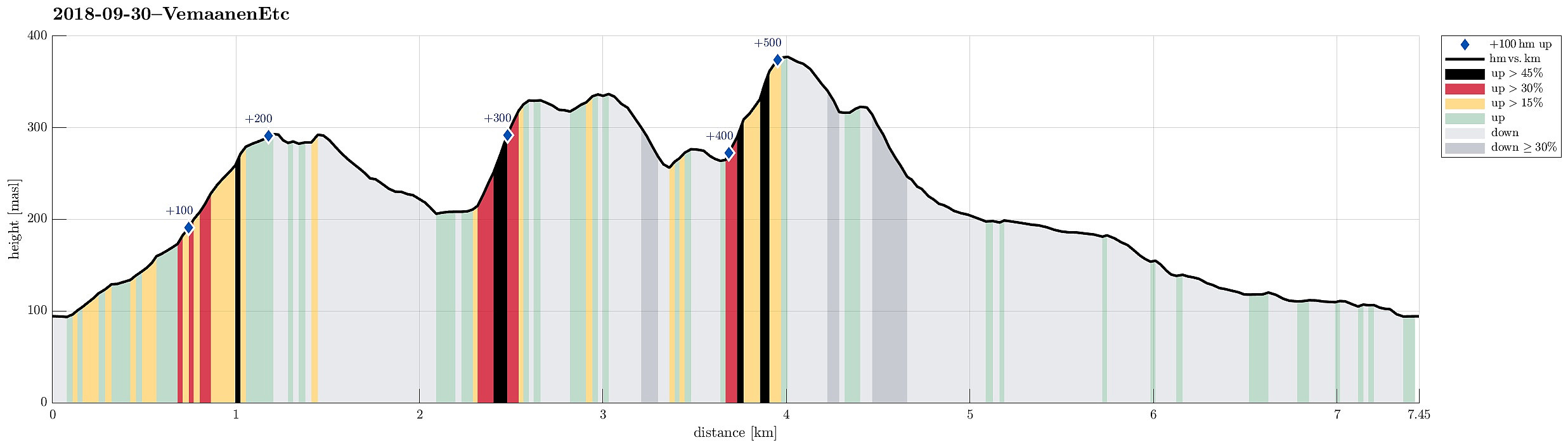 On this day with a "mixed" weather prediction, we decided to do a smaller hike, still trying something new. We parked near the Unneland Kultur og Aktivitetshus at Unnelandsvegen 253, 5268 Haukeland, and walked from there.
Immediately after crossing the bridge over the stream that comes down from Seterdalen (as well as from Rambjørgsgjelet), heading towards Haukelandsvatnet (at Nesvika), we found the path to Vemånen (first passing by Rodalshaugen). This is a very easy to find and nice to walk path, following the ridge (mostly in northern direction) up to Vemånen. Near the top of Vemånen, one gets out of the forest and can enjoy some nice views, in particular over Haukeland and Haukelandsvatnet. The best viewpoint, however, is not at the "top" of Vemånen, but a few >>>
On this day with a "mixed" weather prediction, we decided to do a smaller hike, still trying something new. We parked near the Unneland Kultur og Aktivitetshus at Unnelandsvegen 253, 5268 Haukeland, and walked from there.
Immediately after crossing the bridge over the stream that comes down from Seterdalen (as well as from Rambjørgsgjelet), heading towards Haukelandsvatnet (at Nesvika), we found the path to Vemånen (first passing by Rodalshaugen). This is a very easy to find and nice to walk path, following the ridge (mostly in northern direction) up to Vemånen. Near the top of Vemånen, one gets out of the forest and can enjoy some nice views, in particular over Haukeland and Haukelandsvatnet. The best viewpoint, however, is not at the "top" of Vemånen, but a few >>>
Via Purkedalsgjelet to Kofta etc.
- Date:
- 02.09.2018
- Characteristic:
- Hillwalk
- Duration:
- 7:45h
- Distance:
- 18.2km
 This hike, and in particular the part through Purkedalsgjelet up to Kofta, was one that asked for a careful preparation. It's recommended that you study the circumstances carefully and choose also the weather conditions appropriately. In order to enjoy this hike, you should (a) be at least somewhat experienced with hiking in the mountains around Bergen, in particular also without a path (finding your way, etc.) and (b) choose a dry day on which you can expect that there would not be too much water coming down Purkedalsgjelet (I'd rather not go this hike when snow is melting on Gullfjellet, or after some heavy rain). Take care (and enjoy)! :-)
We parked along the road from Os to Samnanger (#137), which passes Gullfjellet on its eastern (generally very steep) side. Actually, we first missed >>>
This hike, and in particular the part through Purkedalsgjelet up to Kofta, was one that asked for a careful preparation. It's recommended that you study the circumstances carefully and choose also the weather conditions appropriately. In order to enjoy this hike, you should (a) be at least somewhat experienced with hiking in the mountains around Bergen, in particular also without a path (finding your way, etc.) and (b) choose a dry day on which you can expect that there would not be too much water coming down Purkedalsgjelet (I'd rather not go this hike when snow is melting on Gullfjellet, or after some heavy rain). Take care (and enjoy)! :-)
We parked along the road from Os to Samnanger (#137), which passes Gullfjellet on its eastern (generally very steep) side. Actually, we first missed >>>
To Raudlifjellet and back via Hatlelia
- Date:
- 12.08.2018
- Characteristic:
- Hillwalk
- Duration:
- 5:00h
- Distance:
- 10.0km
 We had the (kind of ambitious) plan to walk a round over Nordhordlandskulten, descending to the south from it (even though it was unclear from the consulted maps, whether this should be reasonably doable, given the also quite steep side of the mountain there). To have the car at the right side of the mountain, we parked along Gåssandvegen near a place called Haukeland. The first task was to find the path, which would lead northover in order to bring us to a place from which it would be reasonable to cross over to the main path up to Nordhordlandskulten (the standard approach is from Tømmernes, a little further north). After a little bit of searching, we quickly found the track which leads northwards into Vetlaleitet (a quite nice little valley, in fact!). We then also found the tractor >>>
Slettegga and Nobbane
- Date:
- 11.08.2018
- Characteristic:
- Hillwalk
- Duration:
- 3:00h
- Distance:
- 8.6km
 We parked at the Bontveit saddle (where the street crosses over to Hausdalen). From there, we first followed a gravel road that leads northwards. At about 360mosl, we continued along the road, which leads relatively steeply up to Langemyrskaret on the left. Once up there, we continued along the road first, before then following a path, which leads up to Rambjørgvatnet. From there, we started our real ascent to Slettegga, going in northeastern direction. Getting higher, we enjoyed some dramatically looking views into the direction of Arna (the weather was not all sunny). From the top of Slettegga, we first continued along a path, leading into the direction of Austefjellet. Soon after, however, we left the path to cross over to Nobbane, right next to Slettegga and a little lower in altitude. >>>
Up Stoltzekleiven and back via Fløyen
- Date:
- 06.08.2018
- Characteristic:
- Hillwalk
- Duration:
- 2:30h
- Distance:
- 8.5km
 We took the bus to Sandviken and ascended through some (very) small roads up to Fjellveien in order to get to the start of Stoltzekleiven. A little bit of rain helped to cool us down, while ascending to Sandviksfløyen. From Sandvikspilen it is always a nice view over Bergen! When continuing from there, we could not resist a short dive into Storevatnet, before proceeding towards Fløyen. We took Tippetue (via Vindeggen) down to Bergen, before catching a bus in Olav Kyrres gate. Always a challenge to "run" up Stoltzekleiven as fast as possible! :-)
Selected photos are available as Google photo album .
See also the related FB-page Hiking around Bergen, Norway .
The hiking portal UT.no describes a similar hike .
We took the bus to Sandviken and ascended through some (very) small roads up to Fjellveien in order to get to the start of Stoltzekleiven. A little bit of rain helped to cool us down, while ascending to Sandviksfløyen. From Sandvikspilen it is always a nice view over Bergen! When continuing from there, we could not resist a short dive into Storevatnet, before proceeding towards Fløyen. We took Tippetue (via Vindeggen) down to Bergen, before catching a bus in Olav Kyrres gate. Always a challenge to "run" up Stoltzekleiven as fast as possible! :-)
Selected photos are available as Google photo album .
See also the related FB-page Hiking around Bergen, Norway .
The hiking portal UT.no describes a similar hike .
After-flight hike to Knappen
- Date:
- 05.08.2018
- Characteristic:
- Hillwalk
- Duration:
- 2:00h
- Distance:
- 4.8km
 To stretch our legs a little bit, we decided to make a quick hike over Knappen, ignoring the fact that it rained (more or less). We started from Varden, went first towards Gjeddevatnet, before we went down to Bjørgeveien and from there further to Sandeidbrotet. From there, we continued via a nice path, leading first up to Eldtona, before from there connecting to Såta, the highest point in Knappen (not very high, after all). After enjoying a bit of a view of Grimstadfjorden, we descended to the southern end of Knappetjørna. Before returning back to Varden via Vassteigen, we dived for a short swim into Knappetjørna. All in all, even though the weather was suboptimal, this was a refreshing excursion at the end of the day.
See also the related FB-page Hiking around Bergen, Norway .
Petter Bjørstad has a useful page about Knappen .
To stretch our legs a little bit, we decided to make a quick hike over Knappen, ignoring the fact that it rained (more or less). We started from Varden, went first towards Gjeddevatnet, before we went down to Bjørgeveien and from there further to Sandeidbrotet. From there, we continued via a nice path, leading first up to Eldtona, before from there connecting to Såta, the highest point in Knappen (not very high, after all). After enjoying a bit of a view of Grimstadfjorden, we descended to the southern end of Knappetjørna. Before returning back to Varden via Vassteigen, we dived for a short swim into Knappetjørna. All in all, even though the weather was suboptimal, this was a refreshing excursion at the end of the day.
See also the related FB-page Hiking around Bergen, Norway .
Petter Bjørstad has a useful page about Knappen .
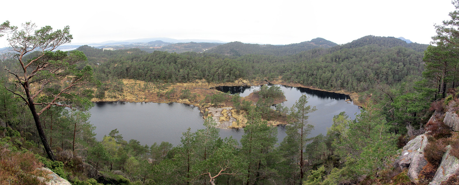
Short hike along the northwestern side of Sælenvatnet
- Date:
- 06.05.2018
- Characteristic:
- Hike
- Duration:
- 0:30h
- Distance:
- 2.3km
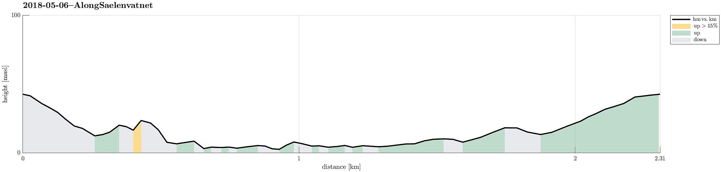 Starting from Varden, this was "only" a short hike along the northwestern side of Sælenvatnet.
Selected photos are available as Google photo album .
See also the related FB-page Hiking around Bergen, Norway .
Starting from Varden, this was "only" a short hike along the northwestern side of Sælenvatnet.
Selected photos are available as Google photo album .
See also the related FB-page Hiking around Bergen, Norway .
Short hike into Kanadaskogen
- Date:
- 05.05.2018
- Characteristic:
- Hillwalk
- Duration:
- 1:00h
- Distance:
- 4.8km
 Starting from Varden in the south of Fyllingsdalen, this was "just" a short and quick hike into Kanadaskogen and around Stora Krokatjørna.
See also the related FB-page Hiking around Bergen, Norway .
Starting from Varden in the south of Fyllingsdalen, this was "just" a short and quick hike into Kanadaskogen and around Stora Krokatjørna.
See also the related FB-page Hiking around Bergen, Norway .
