Archiv - Nach Datum
Archiv - Nach Aktivität
-
Andere Tour (1)
- Kayaking (1)
-
Andere Wintertour (4)
- Schneeschuhtour (4)
-
Fahrradtour (137)
- Fahrradtour Straße (9)
- Fahrradtour gemischt (51)
-
Fußtour (740)
- Bergtour (363)
- Jogging (18)
- Spaziergang (89)
- Wanderung (270)
-
Skitour (4)
- Tourenskilauf (4)
Archiv - Nach Geografie
Peakbookfreunde


Gesammelte Listen
-
Bergen ≥ 50m pf. og ≥ 100 m.o.h.
(87/89)
 97%
97% -
Most dominating tops of the Bergen peninsula
(68/75)
90%
-
Utvalgte topper og turmål i Bergen
(316/350)
90%
-
Alle topper i Bergen
(357/398)
89%
-
Opptur Bergen
(100/113)
88%
-
De syv fjell rundt Bergen
(6/7)
85%
-
Sund ≥ 50m pf.
(14/18)
77%
-
Os ≥ 50m pf.
(25/34)
73%
-
Søyler (fastmerker) i Bergen
(68/100)
68%
-
Fjell ≥ 50m pf.
(21/32)
65%

Biking detour in Fyllingsdalen
- Datum:
- 16.09.2023
- Tourcharakter:
- Fahrradtour
- Tourlänge:
- 1:00h
- Entfernung:
- 12,1km
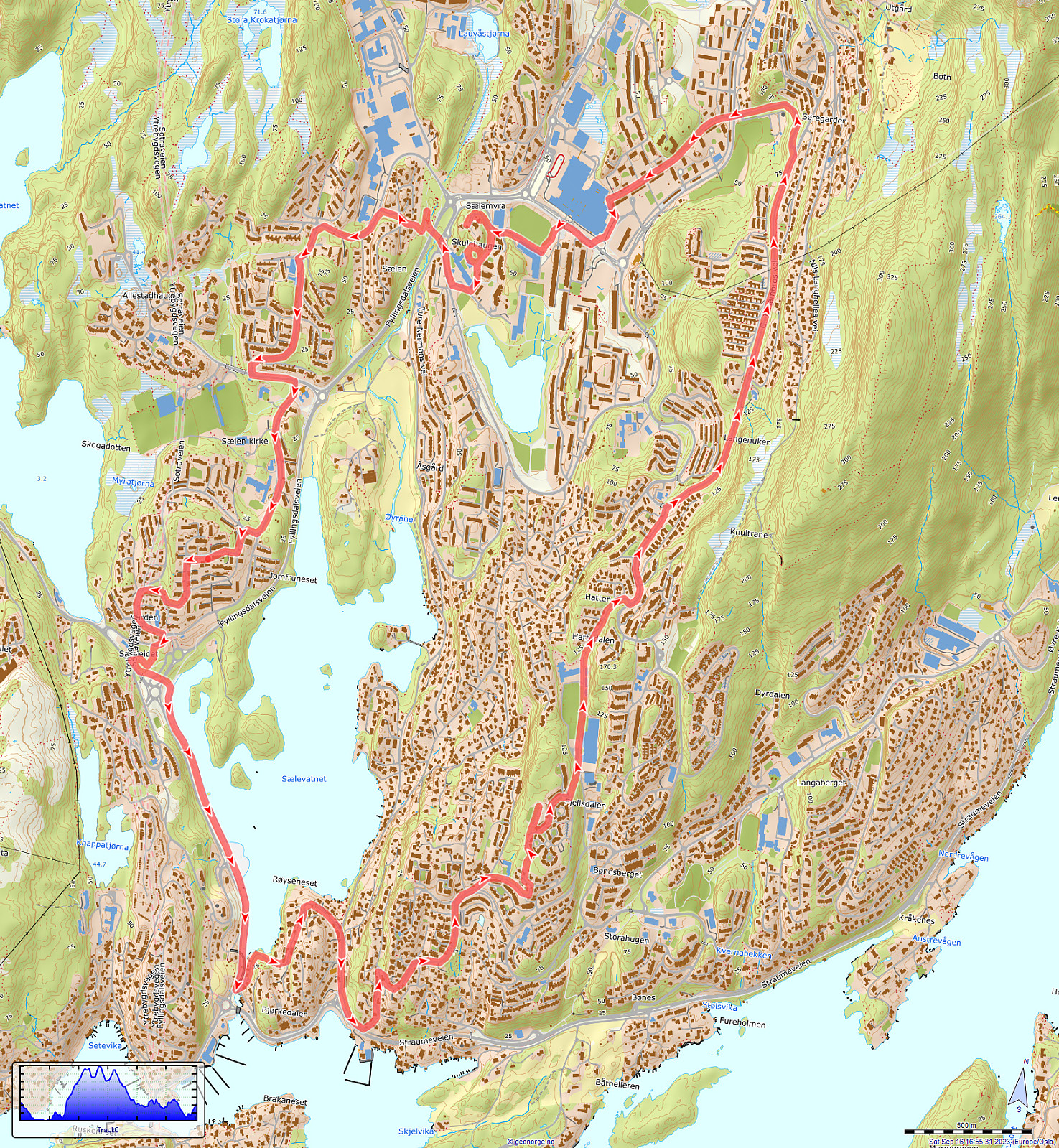 While en route to a local supermarket for some shopping, I decided to bike a little detour. First, I surrounded Sælevatnet in its south. I then took the steep way up to Bønes/Fjellsdalen. I then cycled around Lyshovden in its northeast. After passing by Oasen, I decided to make a brief exploration of Skulehaugen -- kind of strange to passing by this little hill (almost) every day, but never actually making it up to its "top". After that, it was mostly to the shop and then back home -- so not so much to write, today...
See also the related FB-page Hiking around Bergen, Norway .
While en route to a local supermarket for some shopping, I decided to bike a little detour. First, I surrounded Sælevatnet in its south. I then took the steep way up to Bønes/Fjellsdalen. I then cycled around Lyshovden in its northeast. After passing by Oasen, I decided to make a brief exploration of Skulehaugen -- kind of strange to passing by this little hill (almost) every day, but never actually making it up to its "top". After that, it was mostly to the shop and then back home -- so not so much to write, today...
See also the related FB-page Hiking around Bergen, Norway .
Bergens lengste bakke, one of the classics near Bergen!
- Datum:
- 09.09.2023
- Tourcharakter:
- Wanderung
- Tourlänge:
- 5:15h
- Entfernung:
- 12,8km
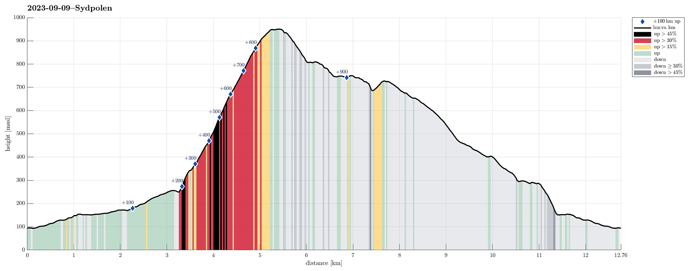 For a while, already, we had discussed that it absolutely was high time, again, for one of the nice classics in the vicinity of Bergen: up to Sydpolen from Brekkedalen! Since the weather seemed to hold throughout the day, we were quick to choose this hike for the day! :-) Driving into Hausdalen from E39 (south of Bergen), we aimed at the parking place at the very end of the road (basically where Brekkedalen splits off from Hausdalen). Hoping that we would not be too late to also find a free spot for our car, we then were relieved to actually find the parking place "only" half full (at about 11h). We quickly got started, heading into Brekkedalen along the gravel road. As soon as we approached Sandane, we also could look up to Sydpolen, already (always an impressive sight). Continuing >>>
Accidental Stemhaugen
- Datum:
- 26.08.2023
- Tourcharakter:
- Fahrradtour gemischt
- Tourlänge:
- 2:00h
- Entfernung:
- 20,2km
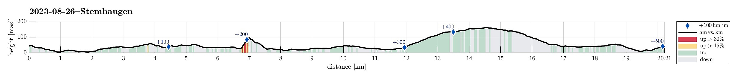 The primary goal of this trip was to just do a bit of shopping! :-) Once on my bike, however, I immediately thought that making a short detour, first, would be good. I thus started along Bjørgeveien and headed northwards towards Bjørndalen. South / southeast of Lyderhorn, I then connected to Liavatnet. As I came towards the northern end of Liavatnet, I thought that this was maybe my chance to include a short visit to Stemhaugen! :-) North of the dam that holds back Liavatnet, I thus left my bike behind and found my way (rather "way") up to Stemhaugen via its northern ridge (no trail, steep, but not difficult). I then crossed over the top of Stemhaugen, enjoying some nice views down to Liavatnet and over to Lyderhorn. On my way down (still in southern direction), I made it >>>
Liatårnet from Liaskjeret
- Datum:
- 11.08.2023
- Tourcharakter:
- Wanderung
- Tourlänge:
- 4:30h
- Entfernung:
- 9,1km
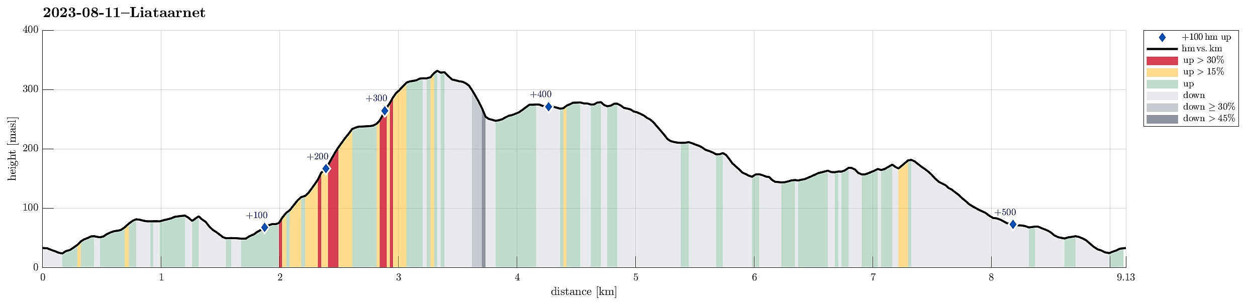 We took the car from Bergen towards the west, crossing over Sotrabrua. In the west of Bildøya, we turned south (onto Døsjevegen), driving to Liaskjeret in the east of Liatårnet. From Liaskjærshallen, we then started our hike with our first goal being the trail that leads up to Liatårnet from Hølo. To get there, we had the choice between walking along Liaskjervegen for a good stretch and the alternative of following a simple trail above (in the west) of the houses. Choosing the latter, we first walked up Elvabakkvegen to get to the nearest trail head near house #11. A few hundred meters further west (and up a little), we then turned right (northwards), aiming for Skoradalen via a simple trail. West of Skogsbrekko, however, we did not really find a good way to continue further to >>>
Møsnuken from Heggeland and Gjemdalsskaret
- Datum:
- 06.08.2023
- Tourcharakter:
- Wanderung
- Tourlänge:
- 3:00h
- Entfernung:
- 7,9km
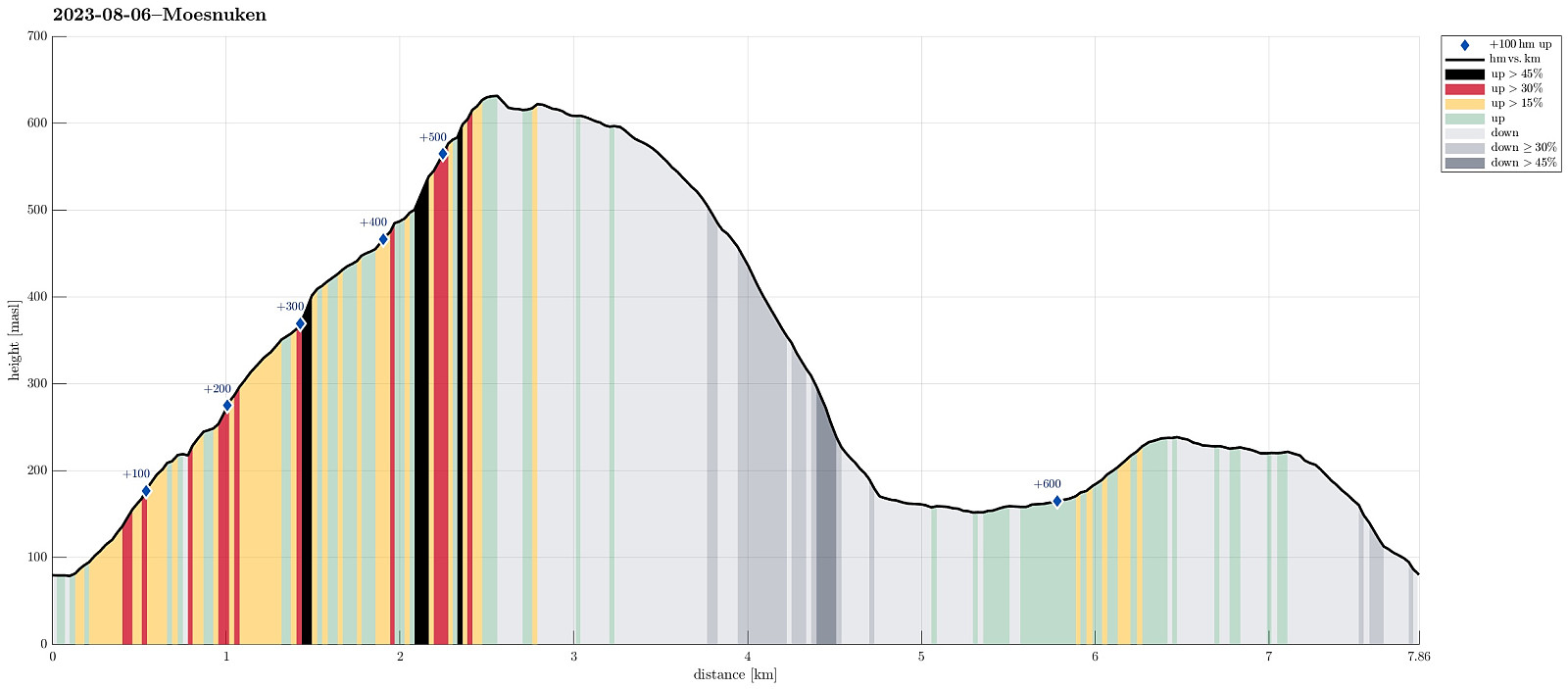 We thought that crossing over Møsnuken from Gjemdal / Heggeland (in the east) to Krokvatnet (in the north) and then returning via Gjemdalsskaret back to the starting point sounded like a nice idea. :-) Accordingly, we took the new E39 connection from Bergen to Osøyro, just to continue into Hegglandsdalen from there (road 579). After passing by Tveitavatnet, we found a place to leave our car (quite near to where Spannsteigselva comes down from Gjemdalsskaret). Instead of following the gravel road up to Gjemdalsskaret from Gjemdal (to then connect to the trail that leads up to Tveitaskaret), we aimed at an ascent route through the forest in the west of Spannsteigselva (without trail). Near house #659 along Hegglandsdalsvegen we stepped onto a simple field road, leading steeply upwards into >>>
Solbakkafjellet from Hausdalen
- Datum:
- 05.08.2023
- Tourcharakter:
- Wanderung
- Tourlänge:
- 3:00h
- Entfernung:
- 9,1km
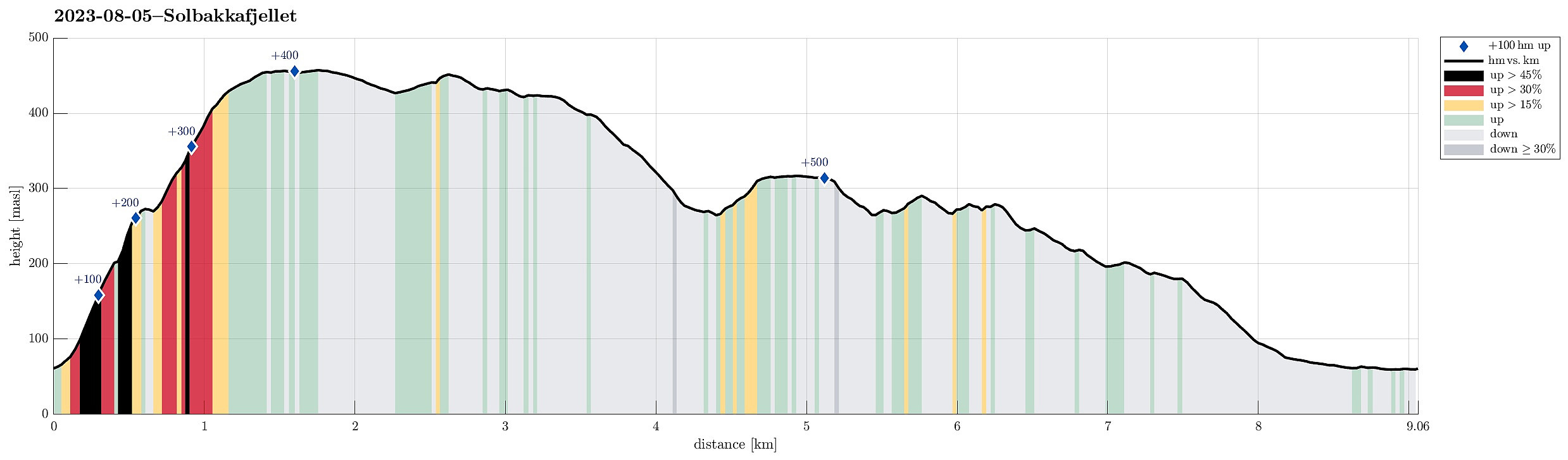 Since we had not been there for a while, we thought that hiking up to Solbakkafjellet once again may nice. This time, however, we decided to approach it from Hausdalen near Haugland. Driving into Hausdalen, we found a place near Haugland, where we could leave the car for a few hours. From there, we started to approach Solbakkafjellet "straight up" (without any trail). The southeastern flank of Solbakkafjellet (Skoralia) is steep and occasionally one needs to find a way around some obstacles on the way up. Still, ascending "straight up" is not really difficult. Within not too long, we accordingly arrived at the top of Solbakkafjellet, paying Petersplassen a short visit (we could not remember this place from our last visit). We then crossed over the long top-ridge of >>>
Bike-hiking Skavdalsfjellet (and some additional hills)
- Datum:
- 23.07.2023
- Tourcharakter:
- Fahrradtour gemischt
- Tourlänge:
- 6:00h
- Entfernung:
- 43,6km
 Due to some unfortunate illness, this excursion was without the usual company. The idea was to first ride my eBike to a suitable starting point and then do a hike from there. Also, I thought to make a hike, which we quite likely would not do together (parts of the planned hike were predicted to be more like a bush war than anything else*), ending up at the area in the northeast of Myrdalsvatnet with its smaller (and honestly speaking also not terribly exciting) hills (Kattuglehaugane, Barkahaugane, Kattuglefjellet, and Preståsen). I also thought to visit two small hills in Skjold (Skjoldhøgda and Storåsen), since they were along my route to Myrdalsvatnet (and since I thought that I'd never visit them otherwise anyway).
Biking around Søråsen, I made my way to Skjold. Finding a good route >>>
Due to some unfortunate illness, this excursion was without the usual company. The idea was to first ride my eBike to a suitable starting point and then do a hike from there. Also, I thought to make a hike, which we quite likely would not do together (parts of the planned hike were predicted to be more like a bush war than anything else*), ending up at the area in the northeast of Myrdalsvatnet with its smaller (and honestly speaking also not terribly exciting) hills (Kattuglehaugane, Barkahaugane, Kattuglefjellet, and Preståsen). I also thought to visit two small hills in Skjold (Skjoldhøgda and Storåsen), since they were along my route to Myrdalsvatnet (and since I thought that I'd never visit them otherwise anyway).
Biking around Søråsen, I made my way to Skjold. Finding a good route >>>
Gjenekletten and Søre Sandknappen on Blomøyna
- Datum:
- 19.06.2023
- Tourcharakter:
- Wanderung
- Tourlänge:
- 3:00h
- Entfernung:
- 7,3km
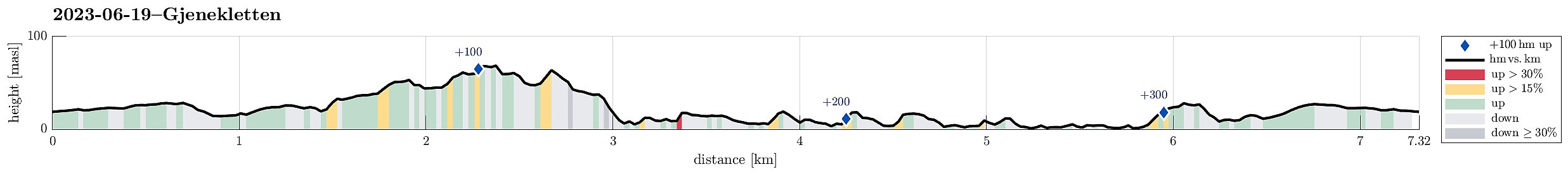 We were up for another trip to Øygarden and chose Blomøyna for a short hike. We left Bergen towards the west and turned right (northwards) on Sotra near Kolltveit. We then followed road #561 until we passed Rong and arrived at Blomøyna via the bridge over Ulvsundet. We then parked right next to road Blomøyvegen (south of Søre Sæle). From there, we first walked along the road (northwards) for a bit (until we had walked around Blomvatnet on our left). There, at Blom, we then left the road towards the right (north) in order to find a connection to Gjenekletten. We first found a proper trail, leading to house #255. Before getting there, we then left this trail and crossed over a little ditch in the northwest of this house. Further north, however, we couldn't see any nice continuation >>>
Gulltjørna from Risnes
- Datum:
- 18.06.2023
- Tourcharakter:
- Wanderung
- Tourlänge:
- 3:00h
- Entfernung:
- 6,6km
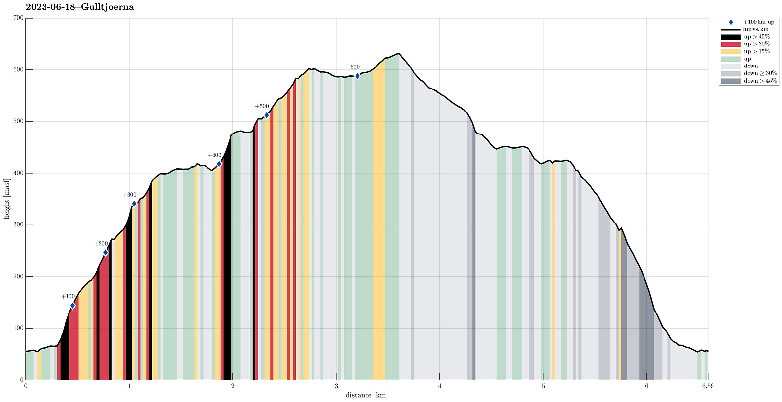 We liked the idea to paying Gulltjørna another visit and we also liked the idea to do it, again, from the north. Following E16 into the east of Bergen, we left the main road near Romslo in order to connect to the old, narrow road that would bring us closer to Risnes. We found a spot where we could park alongside the road just a short stretch before actually getting all the way to Risnes. From there, we walked first for a short stretch along the road in order to get to our starting point of the actual hike. Right next to the bridge over the stream that comes down there through Risnes, we saw that one could use the steps of the water processing building there to get a bit further up (and away from the road). Where the stairs end, however, one needs to revert to actual hiking (there it's >>>
Biking around Hordnesskogen
- Datum:
- 17.06.2023
- Tourcharakter:
- Fahrradtour gemischt
- Tourlänge:
- 2:00h
- Entfernung:
- 31,8km
 With also the other bike repaired, we headed for a new biking-round around Nordåsvatnet. Again, we started our joint ride near the light rail station at Kristianborg, heading south (into the direction of Nesttun). This time, we surrounded Kristianborgvannet on the other, eastern side, though. Following the main bike route southwards, we eventually ended up in Rådalen. There, we decided that we would bike around Hordnesskogen in its south. Afte first following Rådalen further south (to the north of the school at Stend), we then turned right and onto Hordesvegen. Near house #202 along Hordnesvegen, we then came to a parking opportunity for those, who wish to start into Hordnesskogen from the south there. There, we headed into Hordnesskogen (in northwestern direction) for a few hundred >>>
