Archiv - Nach Datum
Archiv - Nach Aktivität
-
Andere Tour (1)
- Kayaking (1)
-
Andere Wintertour (4)
- Schneeschuhtour (4)
-
Fahrradtour (137)
- Fahrradtour Straße (9)
- Fahrradtour gemischt (51)
-
Fußtour (740)
- Bergtour (363)
- Jogging (18)
- Spaziergang (89)
- Wanderung (270)
-
Skitour (4)
- Tourenskilauf (4)
Archiv - Nach Geografie
Peakbookfreunde


Gesammelte Listen
-
Bergen ≥ 50m pf. og ≥ 100 m.o.h.
(87/89)
 97%
97% -
Most dominating tops of the Bergen peninsula
(68/75)
90%
-
Utvalgte topper og turmål i Bergen
(316/350)
90%
-
Alle topper i Bergen
(357/398)
89%
-
Opptur Bergen
(100/113)
88%
-
De syv fjell rundt Bergen
(6/7)
85%
-
Sund ≥ 50m pf.
(14/18)
77%
-
Os ≥ 50m pf.
(25/34)
73%
-
Søyler (fastmerker) i Bergen
(68/100)
68%
-
Fjell ≥ 50m pf.
(21/32)
65%

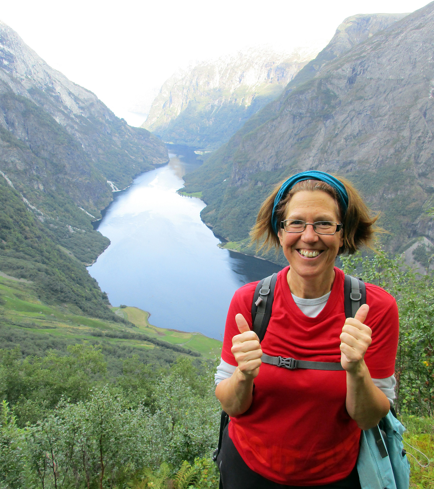
Skarsnosi from Jordalen
- Datum:
- 07.08.2020
- Tourcharakter:
- Wanderung
- Tourlänge:
- 5:00h
- Entfernung:
- 10,1km
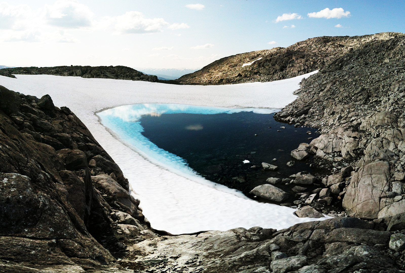
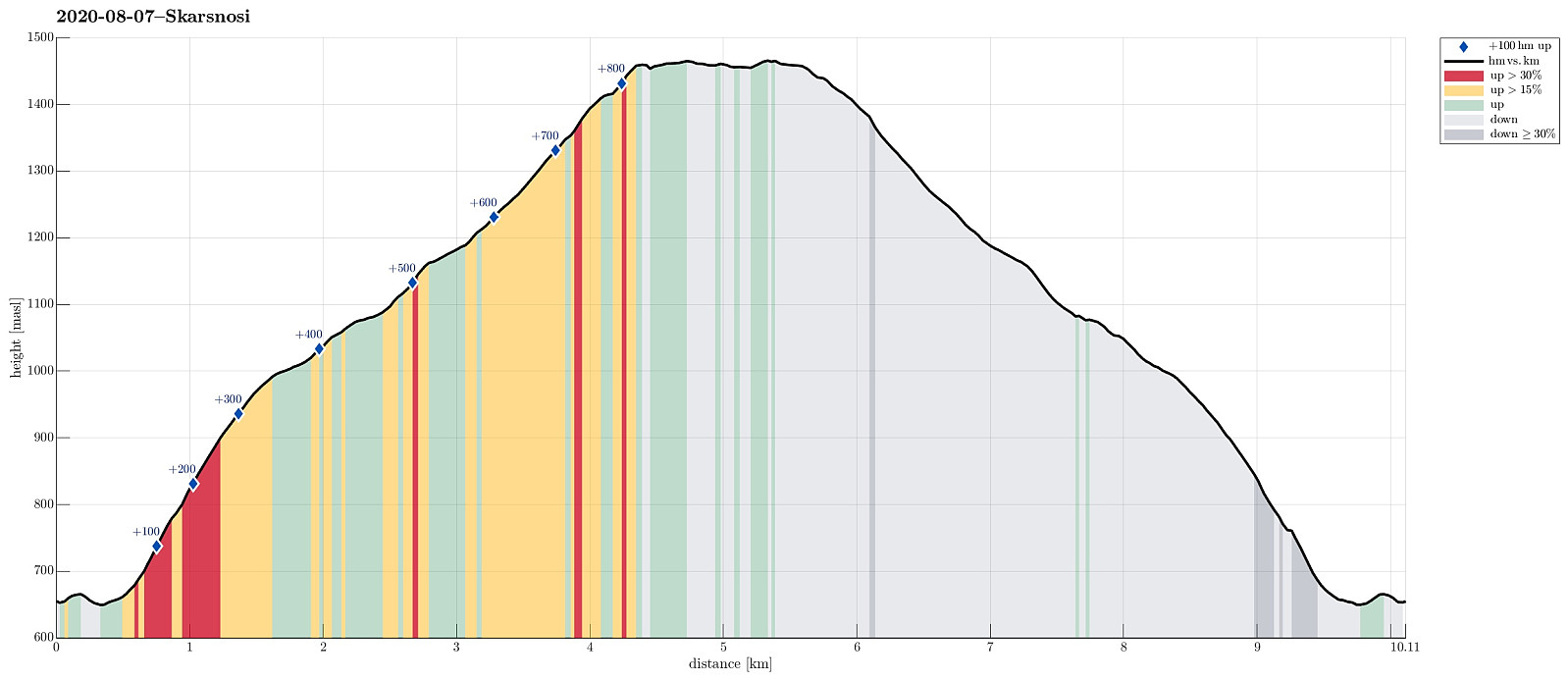 We expected a nice day and thought about Bakkanosi, since we had not been there before. Looking down onto Nærøyfjorden from this place sounds like a worthwhile experience! We thus drove along E16 into the direction of Gudvangen, passing by Stalheim. Quite a bit down in Nærøydalen, we then turned left and used the new tunnel up to Jordalen. Not far up in Jordalen, where Slettedalen comes down from the East, one would park to start the "standard hike" to Bakkanosi (through Slettedalen). Coming there, we were shocked about the relatively large number of parked cars and immediately changed our plan. Instead of Bakkanosi, we now planned for Skarsnosi, not far from Bakkanosi. To get up there, we had thought to hike up the next valley (north of Slettedalen). To do so, we drove >>>
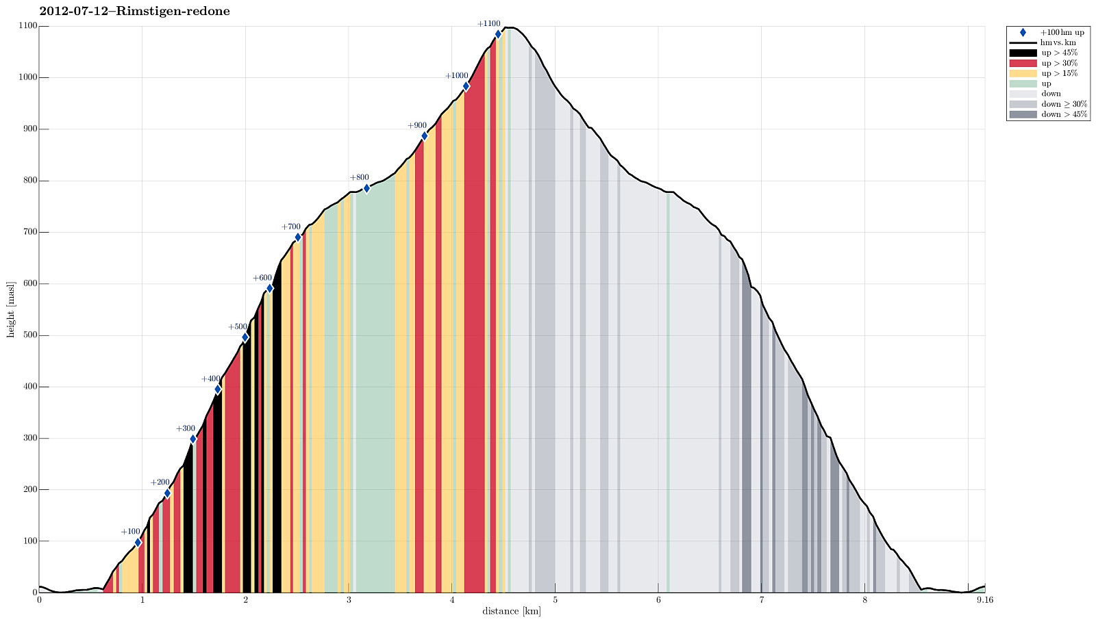
Rimstigfjellet via Rimstigen
- Datum:
- 26.08.2018
- Tourcharakter:
- Bergtour
- Tourlänge:
- 6:00h
- Entfernung:
- 10,2km
 We took road E16 to Gudvangen first, before continuing from there towards Bakka on the western side of Nærøyfjorden. Only a short bit after Bakka, we found a good way to park next to the road. We then hiked the impressive Rimstigen up---what a path up through this very steep terrain right next to the fjord?! Wow! At about 700mosl, the path flattens out (a bit), leading into a side valley, exending westwards (and away from the fjord). Up there, it is really very lovely! After walking for short along a not so steep path, the trail heads up Skarsbakkane (steep again), right next to a little stream (also called Tufteelvi up there?) with a nice waterfall quite high up on the mountain side! At about 1100mosl, one gets over "the second step" in this hike, meeting Skarsvotni right >>>
Jordalsnuten from Jordalen
- Datum:
- 25.08.2018
- Tourcharakter:
- Bergtour
- Tourlänge:
- 3:30h
- Entfernung:
- 5,8km
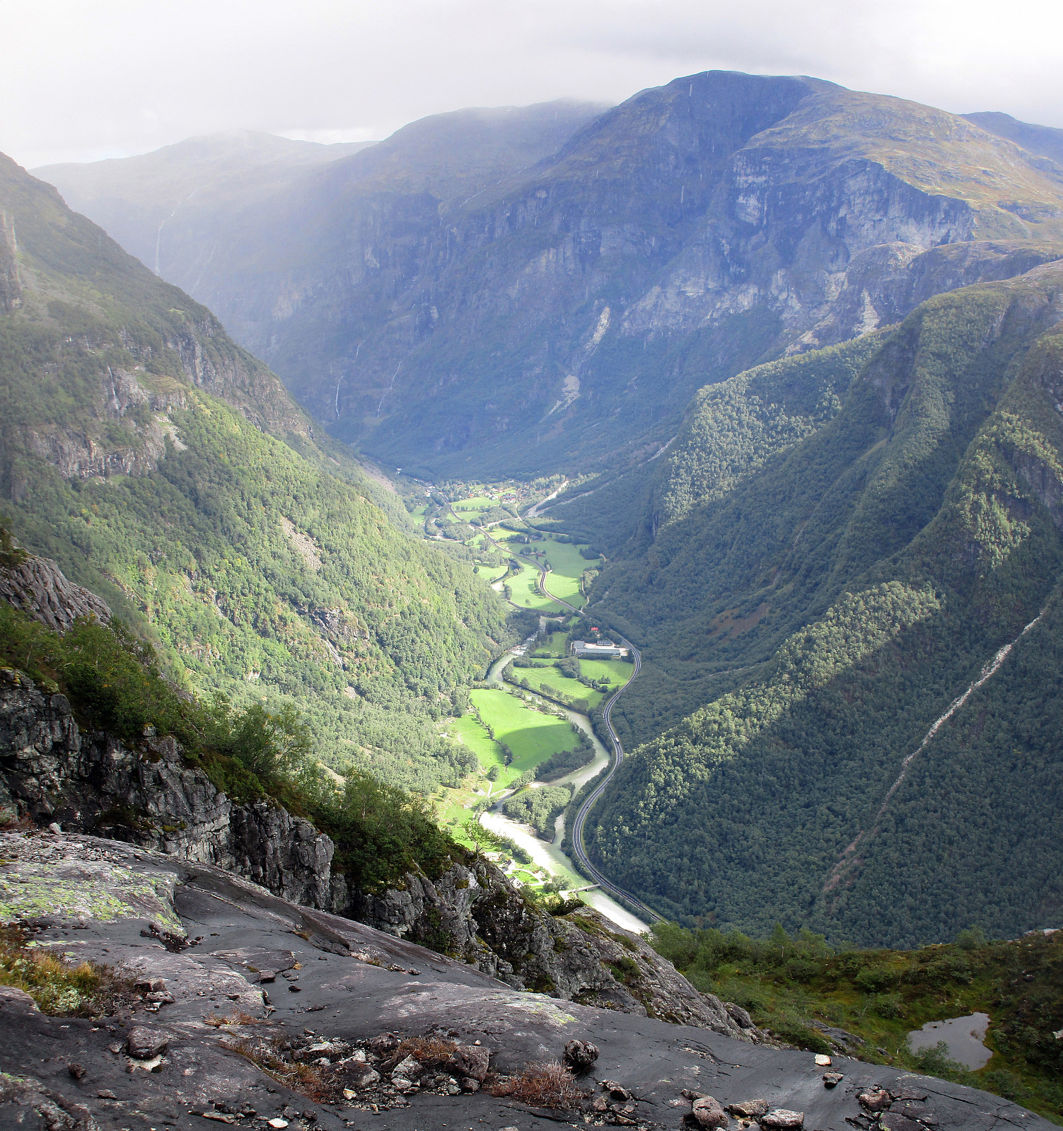 We took road E16 into direction of Gudvangen first and turned to the left (towards Jordalen) after descending into Nærøydalen below Stalheim. We then drove through the new tunnel (now on the eastern side of the valley) up to Jordalen. After leaving the tunnel, we crossed one bridge immediately, before parking the car just ahead of the next bridge. From there we hiked, first over the bridge to the other side of Jordalselvi (to its eastern side), then southwards along the steep eastern side of the valley (into the direction of Jordalsnuten), following a proper path (note that the trail head is not really easy to see; we needed a bit of searching until we found it). It's interesting, also, that the path leads first (more or less) horizontally (with quite a bit of up and down, though) out >>>
Grindaflethytta
- Datum:
- 23.07.2014
- Tourcharakter:
- Wanderung
- Tourlänge:
- 15:00h
- Entfernung:
- 43,7km
 Two days tour from Ljosanbotn (arrival with the train from Bergen) -- first day to Grindflethytta (via a really well marked trail, including three summer bridges); then, next day, first along the marked trail towards Fyre (up to the pass near Stangahøgdi, where the trail starts to descend into Øvsthusdalen), before then following the ridge up to Kaldanuten (no trail along this part) and then down (via Bjørndalsvatnet) into Bjørndalen and out to Brandset. An intense hike, alltogether: about 42km and about 15h out in the beautiful nature.
Selected photos are available as Google photo album .
Two days tour from Ljosanbotn (arrival with the train from Bergen) -- first day to Grindflethytta (via a really well marked trail, including three summer bridges); then, next day, first along the marked trail towards Fyre (up to the pass near Stangahøgdi, where the trail starts to descend into Øvsthusdalen), before then following the ridge up to Kaldanuten (no trail along this part) and then down (via Bjørndalsvatnet) into Bjørndalen and out to Brandset. An intense hike, alltogether: about 42km and about 15h out in the beautiful nature.
Selected photos are available as Google photo album .