Arkiv - dato
Arkiv - aktivitet
-
Annen tur (1)
- Kajakkpadling (1)
-
Annen vintertur (4)
- Trugetur (4)
- Fottur (740)
-
Skitur (4)
- Fjellskitur (4)
-
Sykkeltur (137)
- Blandet sykling (51)
- Gatesykling (9)
Arkiv - Etter geografi
"Peakbookvenner"


Lister jeg samler etter
-
Bergen ≥ 50m pf. og ≥ 100 m.o.h.
(87/89)
 97%
97% -
Most dominating tops of the Bergen peninsula
(68/75)
90%
-
Utvalgte topper og turmål i Bergen
(316/350)
90%
-
Alle topper i Bergen
(357/398)
89%
-
Opptur Bergen
(100/113)
88%
-
De syv fjell rundt Bergen
(6/7)
85%
-
Sund ≥ 50m pf.
(14/18)
77%
-
Os ≥ 50m pf.
(25/34)
73%
-
Søyler (fastmerker) i Bergen
(68/100)
68%
-
Fjell ≥ 50m pf.
(21/32)
65%

Two old stone crosses in Eivindvik
- Dato:
- 09.07.2023
- Turtype:
- Spasertur
- Turlengde:
- 0:30t
- Distanse:
- 0,7km
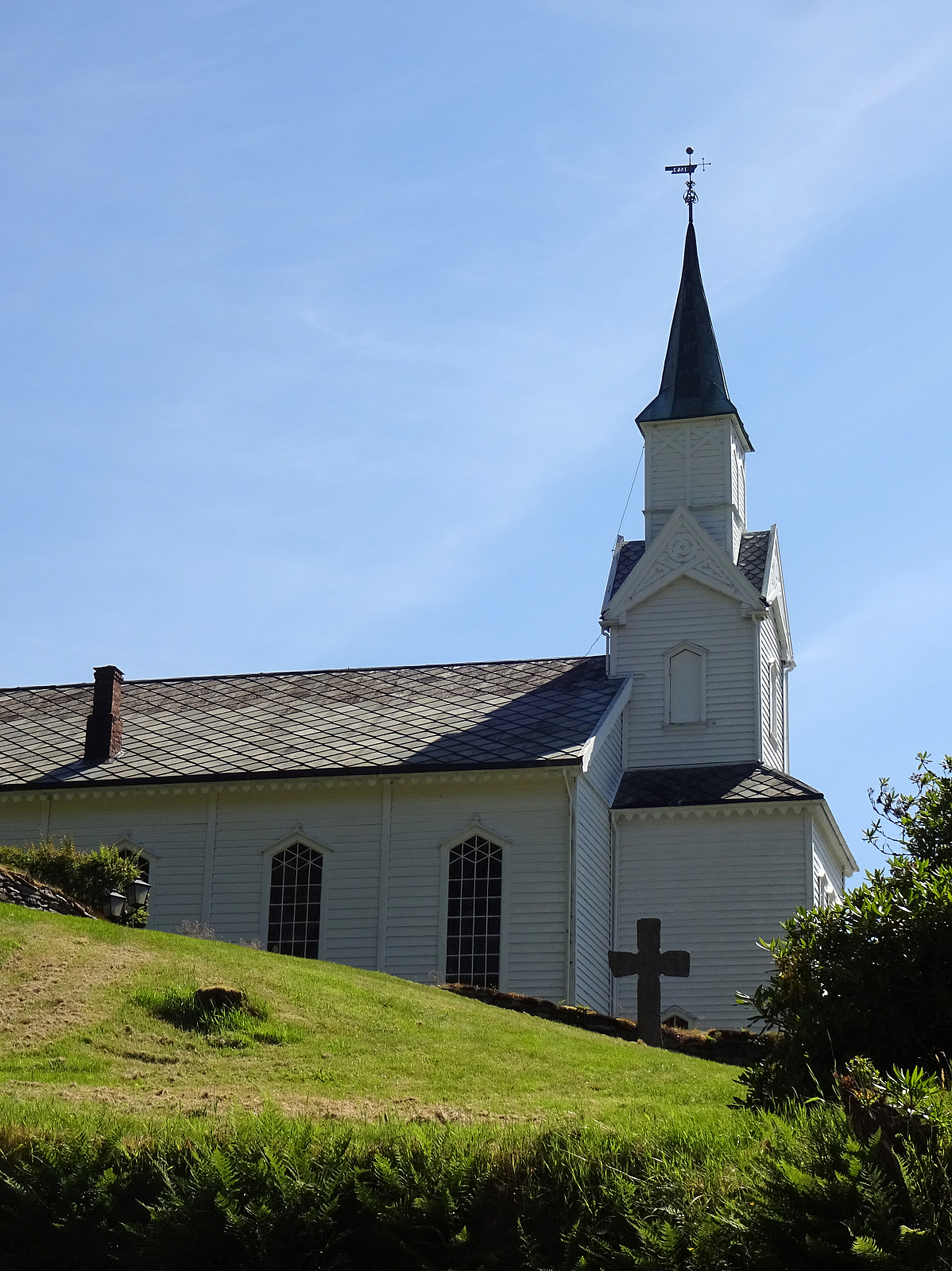 After visiting Gulatinget east of Eivindvik, we continued to Eivindvik to see the two old stone crosses there, also. We parked near the harbor and first walked up to Gulen church (east of the harbor) to see the first cross (Olavskorset). It's standing there with some help now after it broke into two when a nearby tree was cut down in 2012. From there, one can already see the other cross (Korset i Krossteigen), standing a bit up in Krossteigen some (maybe) 250 meters further north. An accordingly short walk brought us up there then. This second cross is interesting as it seems to show some celtic flair. To compensate for that, maybe, they added a smaller, Latin cross (by embossing it out of the main cross). Clearly worth a close look! :-)
Selected photos are available as Google photo album .
See also the related FB-page >>>
After visiting Gulatinget east of Eivindvik, we continued to Eivindvik to see the two old stone crosses there, also. We parked near the harbor and first walked up to Gulen church (east of the harbor) to see the first cross (Olavskorset). It's standing there with some help now after it broke into two when a nearby tree was cut down in 2012. From there, one can already see the other cross (Korset i Krossteigen), standing a bit up in Krossteigen some (maybe) 250 meters further north. An accordingly short walk brought us up there then. This second cross is interesting as it seems to show some celtic flair. To compensate for that, maybe, they added a smaller, Latin cross (by embossing it out of the main cross). Clearly worth a close look! :-)
Selected photos are available as Google photo album .
See also the related FB-page >>>
Gulatinget near Eivindvik
- Dato:
- 09.07.2023
- Turtype:
- Spasertur
- Turlengde:
- 0:30t
- Distanse:
- 0,6km
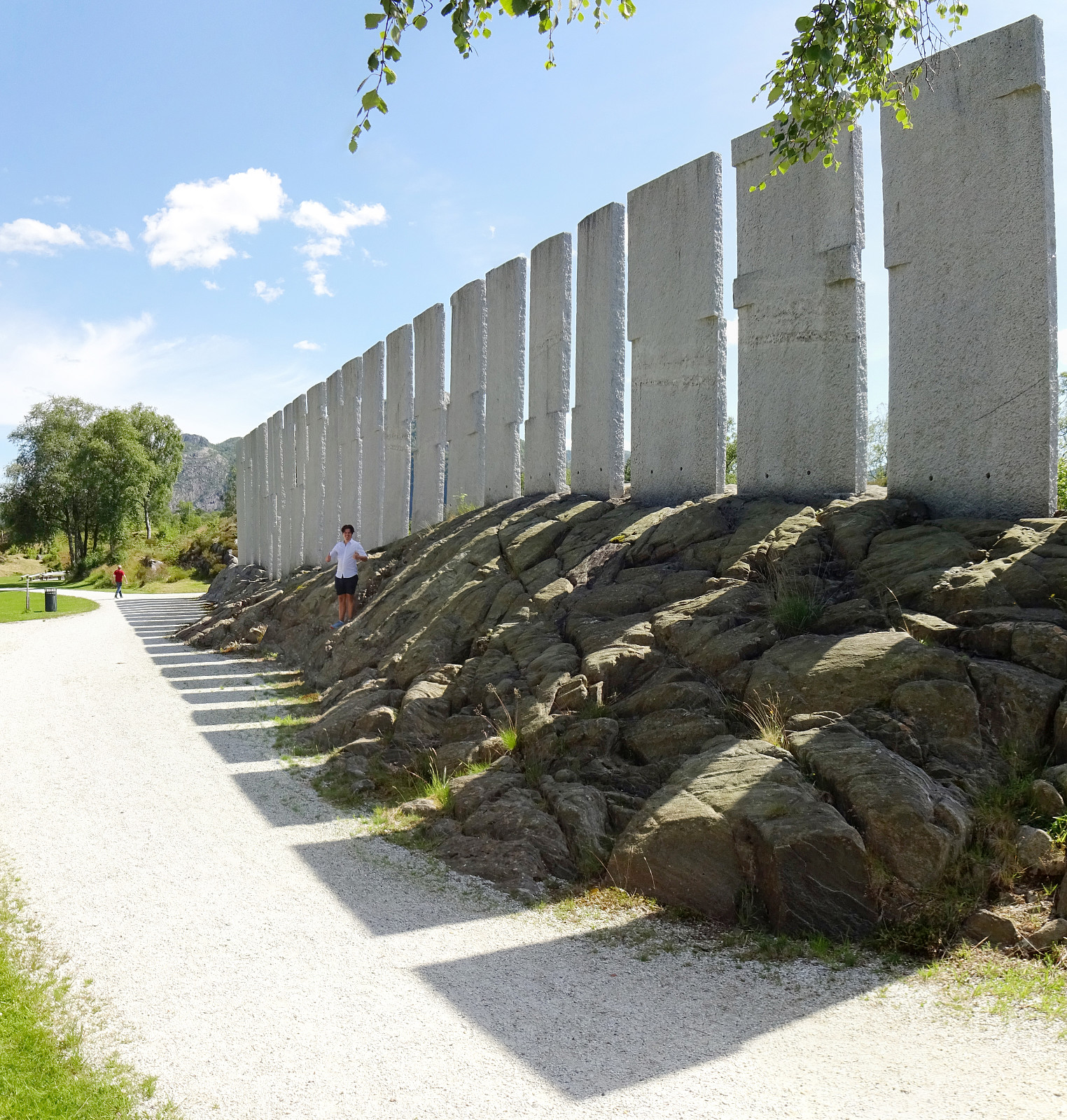 On our way northwards through Gulen, we stopped by Gulatinget near Eivindvik. Following road 605 from Nordgulen (and road 57 there) we stopped once near Guløyna and explored the park (Tusenårsstaden) and the monument of Bård Breivik (Tingveggen). We also enjoyed a nice chat with one person there, who was very kind to explain some of the related history to us! :-)
Selected photos are available as Google photo album .
See also the related FB-page Hiking around Bergen, Norway .
There's also an official web page of Gulatinget .
On our way northwards through Gulen, we stopped by Gulatinget near Eivindvik. Following road 605 from Nordgulen (and road 57 there) we stopped once near Guløyna and explored the park (Tusenårsstaden) and the monument of Bård Breivik (Tingveggen). We also enjoyed a nice chat with one person there, who was very kind to explain some of the related history to us! :-)
Selected photos are available as Google photo album .
See also the related FB-page Hiking around Bergen, Norway .
There's also an official web page of Gulatinget .
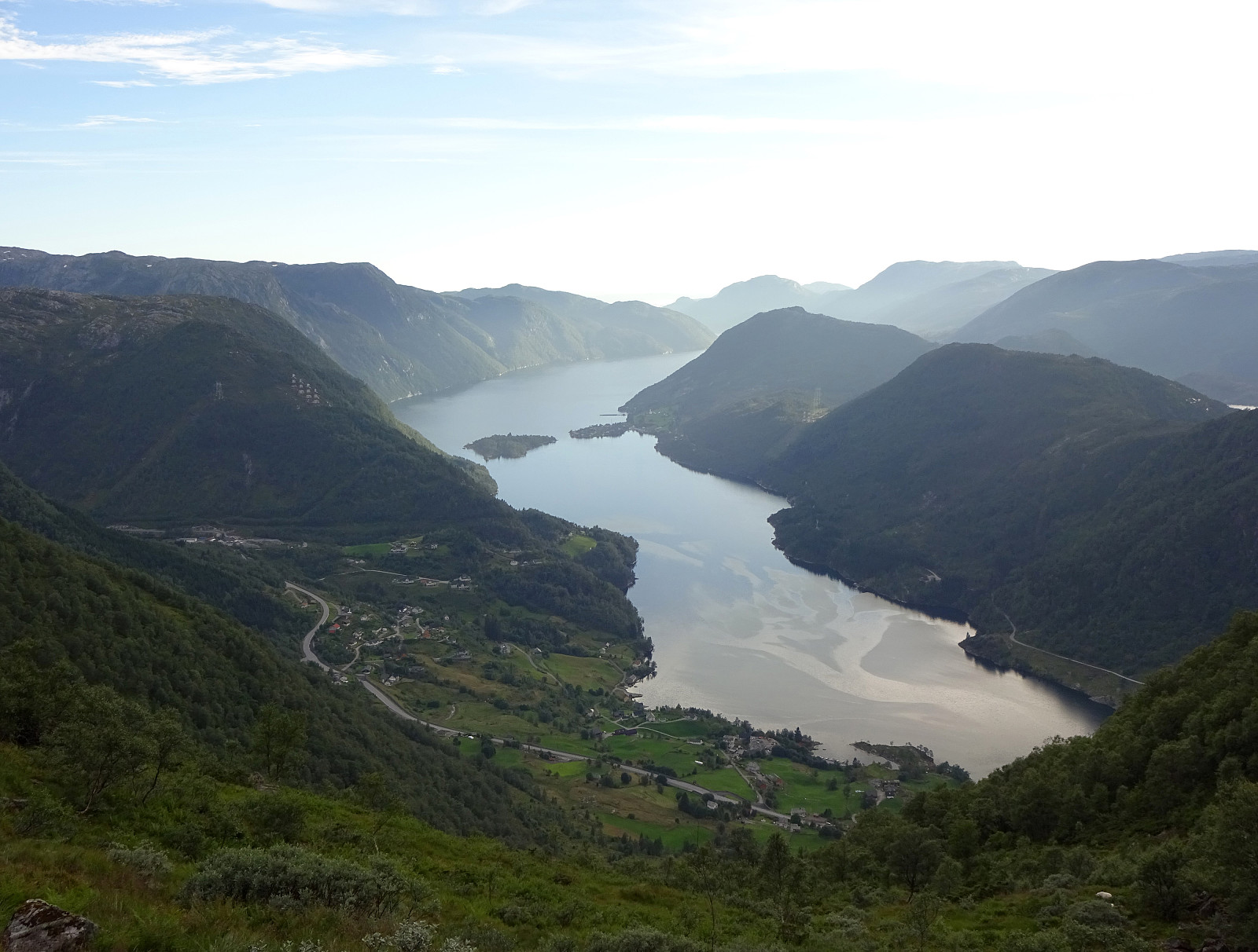
Storeggene, Rabben, Blåfjellet, and Arnipa
- Dato:
- 12.07.2021
- Turtype:
- Fottur
- Turlengde:
- 6:30t
- Distanse:
- 13,9km
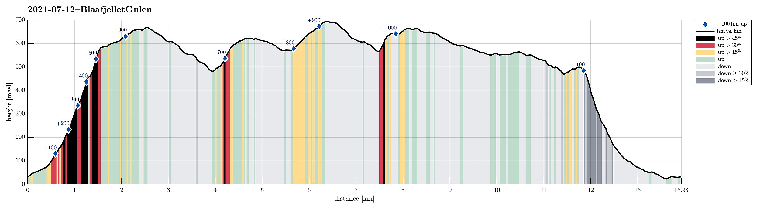 On our way from Bergen to Solund, we wanted to include one hike in Gulen. When checking the map for opportunities, reading also another trip report here on Peakbook , we got tempted to go a nice round in the east of Nordgulen. In order to get to the starting point (at Nordgulen), we drove northwards from Bergen, leaving road E39 at about Knarvik to continue to Mongstad from where we then took a ferry over to Sløvågen. From there, we continued along road 57 (into the direction of Rutledalen), driving first along Eidsfjorden and then further along Nordgulfjorden. Only several hundreds of meters from the northern end of Nordgulvågen, we left road 57 towards the east in order to park somewhere in the area of Tveit. After asking one of the locals, we conveniently parked right next to a playgroud in the northeast of Tveit.
Already >>>
On our way from Bergen to Solund, we wanted to include one hike in Gulen. When checking the map for opportunities, reading also another trip report here on Peakbook , we got tempted to go a nice round in the east of Nordgulen. In order to get to the starting point (at Nordgulen), we drove northwards from Bergen, leaving road E39 at about Knarvik to continue to Mongstad from where we then took a ferry over to Sløvågen. From there, we continued along road 57 (into the direction of Rutledalen), driving first along Eidsfjorden and then further along Nordgulfjorden. Only several hundreds of meters from the northern end of Nordgulvågen, we left road 57 towards the east in order to park somewhere in the area of Tveit. After asking one of the locals, we conveniently parked right next to a playgroud in the northeast of Tveit.
Already >>>
Around Hopsdalen
- Dato:
- 31.07.2020
- Turtype:
- Fottur
- Turlengde:
- 8:30t
- Distanse:
- 22,4km
 We drove along road E39 from Bergen northwards (into the direction of Masfjorden). After driving down through the long Masfjordtunnelen and passing through Matre at the very end of Matresfjorden, we crossed over to Haugsvær "behind" Nonklettfjellet. Before the main road (E39) disappears into another tunnel, we turned left in Haugsvær and parked right there.
Our (slightly ambitious) plan for the afternoon was to go around Hopsdalen (from Høgfjellet via Grønefjellet to Gavlen, and back via Rustefjellet). Considering the steep sides of Hopsdalen, we had looked at the map regarding a possible place for getting up to the top of the surrounding mountains. Near Indre Skjerjehogen, on the north side of Haugsværfjorden, we had thought that it should be possible to reach saddle Sygnegga >>>
We drove along road E39 from Bergen northwards (into the direction of Masfjorden). After driving down through the long Masfjordtunnelen and passing through Matre at the very end of Matresfjorden, we crossed over to Haugsvær "behind" Nonklettfjellet. Before the main road (E39) disappears into another tunnel, we turned left in Haugsvær and parked right there.
Our (slightly ambitious) plan for the afternoon was to go around Hopsdalen (from Høgfjellet via Grønefjellet to Gavlen, and back via Rustefjellet). Considering the steep sides of Hopsdalen, we had looked at the map regarding a possible place for getting up to the top of the surrounding mountains. Near Indre Skjerjehogen, on the north side of Haugsværfjorden, we had thought that it should be possible to reach saddle Sygnegga >>>
