Archiv - Nach Datum
Archiv - Nach Aktivität
-
Andere Tour (1)
- Kayaking (1)
-
Andere Wintertour (4)
- Schneeschuhtour (4)
-
Fahrradtour (137)
- Fahrradtour Straße (9)
- Fahrradtour gemischt (51)
-
Fußtour (740)
- Bergtour (363)
- Jogging (18)
- Spaziergang (89)
- Wanderung (270)
-
Skitour (4)
- Tourenskilauf (4)
Archiv - Nach Geografie
Peakbookfreunde


Gesammelte Listen
-
Bergen ≥ 50m pf. og ≥ 100 m.o.h.
(87/89)
 97%
97% -
Most dominating tops of the Bergen peninsula
(68/75)
90%
-
Utvalgte topper og turmål i Bergen
(316/350)
90%
-
Alle topper i Bergen
(357/398)
89%
-
Opptur Bergen
(100/113)
88%
-
De syv fjell rundt Bergen
(6/7)
85%
-
Sund ≥ 50m pf.
(14/18)
77%
-
Os ≥ 50m pf.
(25/34)
73%
-
Søyler (fastmerker) i Bergen
(68/100)
68%
-
Fjell ≥ 50m pf.
(21/32)
65%

Stålet from Ytre Honningsvåg
- Datum:
- 10.07.2023
- Tourcharakter:
- Wanderung
- Tourlänge:
- 2:00h
- Entfernung:
- 4,0km
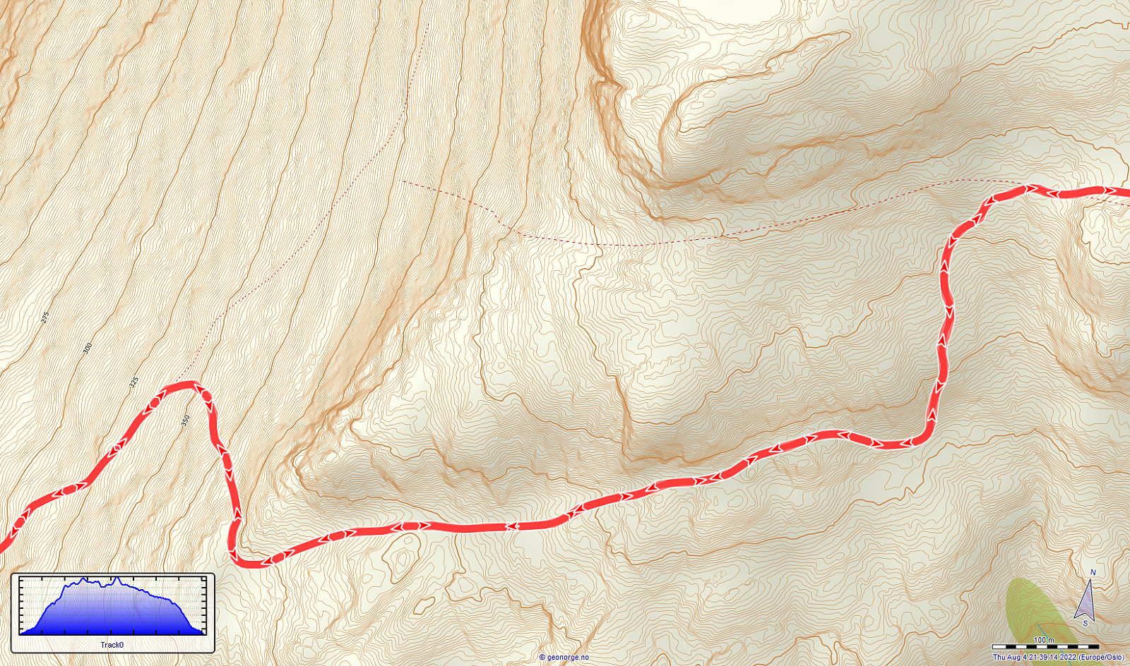
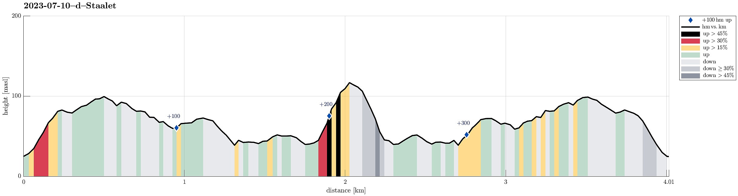 After not seeing much on Vestkapp , we continued to Honningsvågen to make an attempt at Stålet (as far north as you can get on Stadlandet, or so). We found a convenient place to park in Ytre Honningsvåg, right next to the trail head (place for about two cars). From there, we followed a marked trail that extends northwards from Ytre Honningsvåg, traversing the quite steep western slopes of Storebruna, Storeknausen, and Stålsegga at "half height" (or so). While this hike is not long and you also don't have to make many height meters, just the matter of fact that you traverse a relatively steep mountain side (basically all the way out and in), requires a bit of extra care. Also, if the condition should be wet, there may be risks to slip, which could be quite bad in the steepest sections. >>>
Vestkapp on Stadlandet
- Datum:
- 10.07.2023
- Tourcharakter:
- Spaziergang
- Tourlänge:
- 0:30h
- Entfernung:
- 0,6km
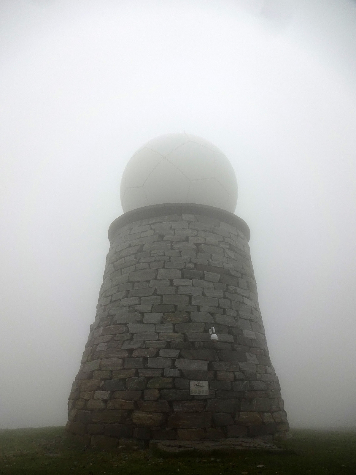 After first paying Vågsøy and Måløy a short visit, we continued to Stadlandet. Our first stop was Vestkapp on Kjerringa in the northwest of Stadlandet. Taking the road up to a parking spot quite close to the actual top, we eventually entered some very thick (and wet) clouds that enshrouded all of the top. Even just a few meters from the massive meteorological radar station on top of Kjerringa we had some difficulties to actually find and see it! :-) Since our views were extremely limited anyway (and it was quite a bit wet, also!), we decided to not stay there for any significant time, but return to our car soon, instead, with our next goal, Stålet , in front of us! :-)
Selected photos are available as Google photo album .
See also the related FB-page Hiking around Bergen, Norway .
After first paying Vågsøy and Måløy a short visit, we continued to Stadlandet. Our first stop was Vestkapp on Kjerringa in the northwest of Stadlandet. Taking the road up to a parking spot quite close to the actual top, we eventually entered some very thick (and wet) clouds that enshrouded all of the top. Even just a few meters from the massive meteorological radar station on top of Kjerringa we had some difficulties to actually find and see it! :-) Since our views were extremely limited anyway (and it was quite a bit wet, also!), we decided to not stay there for any significant time, but return to our car soon, instead, with our next goal, Stålet , in front of us! :-)
Selected photos are available as Google photo album .
See also the related FB-page Hiking around Bergen, Norway .
Kannesteinen on Vågsøy
- Datum:
- 10.07.2023
- Tourcharakter:
- Spaziergang
- Tourlänge:
- 0:30h
- Entfernung:
- 0,2km
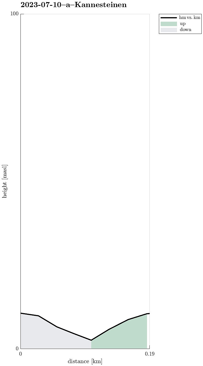 On our way to Stadlandet, we also paid Vågsøy and Måløy a visit. On Vågsøy, we then also drove out to Kannesteinen near Nordoppedalen. Not only is this stone impressive with its particular shape, but also the whole scenery around Torskangerpollen is worth seeing! :-)
Selected photos are available as Google photo album .
See also the related FB-page Hiking around Bergen, Norway .
See the Norwegian Wikipedia for a page about Kannesteinen .
On our way to Stadlandet, we also paid Vågsøy and Måløy a visit. On Vågsøy, we then also drove out to Kannesteinen near Nordoppedalen. Not only is this stone impressive with its particular shape, but also the whole scenery around Torskangerpollen is worth seeing! :-)
Selected photos are available as Google photo album .
See also the related FB-page Hiking around Bergen, Norway .
See the Norwegian Wikipedia for a page about Kannesteinen .
Trollefjellet
- Datum:
- 29.07.2022
- Tourcharakter:
- Wanderung
- Tourlänge:
- 6:00h
- Entfernung:
- 11,6km
 With all the many and wonderful mountains all around, we decided to not drive all too much and rather make a hike close to where we were staying. The impressive cliff of Trollefjellet immediately came to mind and after a short look at the map, it appeared possible to ascend to Trollefjellet via its western (steep!) ridge. After briefly consulting with one from Indrehus, we not only learned that he had made this ascent already before, but also got permission to drive up a little along the forest road in the south of Storeelva. This brought us up to about 200mosl (and quite a bit nearer to the cliff!) and we parked where the forrest road turns right, away from Storeelva and up Nevredalen. From there, we then followed the forrest road further up. This brought us almost perfectly to the saddle >>>
Hornelen (and Storenipa and Svartevassegga) from Berleneset
- Datum:
- 28.07.2022
- Tourcharakter:
- Wanderung
- Tourlänge:
- 8:00h
- Entfernung:
- 16,4km
 One motivation to drive all the way from Bergen to Bremanger was the prospect of hiking Hornelen, i.e., a mountain that we had heard/read repeatedly about. From the place, where we stayed over night, in the southwest of Svelgen, it's not a really long drive to get to Bremangerlandet. Especially Skatestraumtunnelen helps to get over without any waiting times. The day before, on our hike on Batalden , we had learned that ascending Hornelen from Berleneset should be nice. Accordingly, we did not follow the main trail (from Hornskor), but followed road 616 a little further to the west, before turning left and right into Berleporten, i.e., a tunnel that leads to the other, southern side of the mountains, where Berlepollen cuts deep into Bremangerlandet. More or less right after leaving the tunnel, we then turned >>>
