Archive - Date
Archive - Activity
-
Bike trip (137)
- Bike trip - mixed (51)
- Bike trip - road (9)
-
Other trip (1)
- Kayaking (1)
-
Other winter trip (4)
- Snowshoe trip (4)
- Ski trip (4)
- Trip by foot (740)
Archive - Geography
Peakbook-Friends


Collected lists
-
Bergen ≥ 50m pf. og ≥ 100 m.o.h.
(87/89)
 97%
97% -
Most dominating tops of the Bergen peninsula
(68/75)
90%
-
Utvalgte topper og turmål i Bergen
(316/352)
89%
-
Alle topper i Bergen
(357/400)
89%
-
Opptur Bergen
(100/113)
88%
-
De syv fjell rundt Bergen
(6/7)
85%
-
Sund ≥ 50m pf.
(14/18)
77%
-
Os ≥ 50m pf.
(25/34)
73%
-
Søyler (fastmerker) i Bergen
(68/100)
68%
-
Fjell ≥ 50m pf.
(21/32)
65%

Bulandet by bike (and Høgkletten)
- Date:
- 08.09.2024
- Characteristic:
- Bike trip - mixed
- Duration:
- 5:00h
- Distance:
- 31.5km
 We got onto our bikes on Værøyna and headed westwards into the direction of Bulandet along Nordsjøvegen. After crossing over several bridges, we made our first stop on Gjørøyna to take a look at "Ro" by artist Geir Hjetland. From there, we continued further southwestwards until we "hit" the end of the road at Halsøy. There, we stepped up to Slotteholmen to enjoy some views. We then biked over to Nikkjøyna and from there further to Hellersøyna, where we walked a little bit southwards to see the sculpture of Berte and Hansine. Then, we biked back to Værøyna (along the same road that we had taken to Bulandet, i.e., Nordsjøvegen). At Værøyna, we had a brief discussion and decided that only one of us would also include the short hike up to Høgkletten. I thus >>>
Instenova and Ytstenova on Alden
- Date:
- 07.09.2024
- Characteristic:
- Hike
- Duration:
- 4:00h
- Distance:
- 6.2km
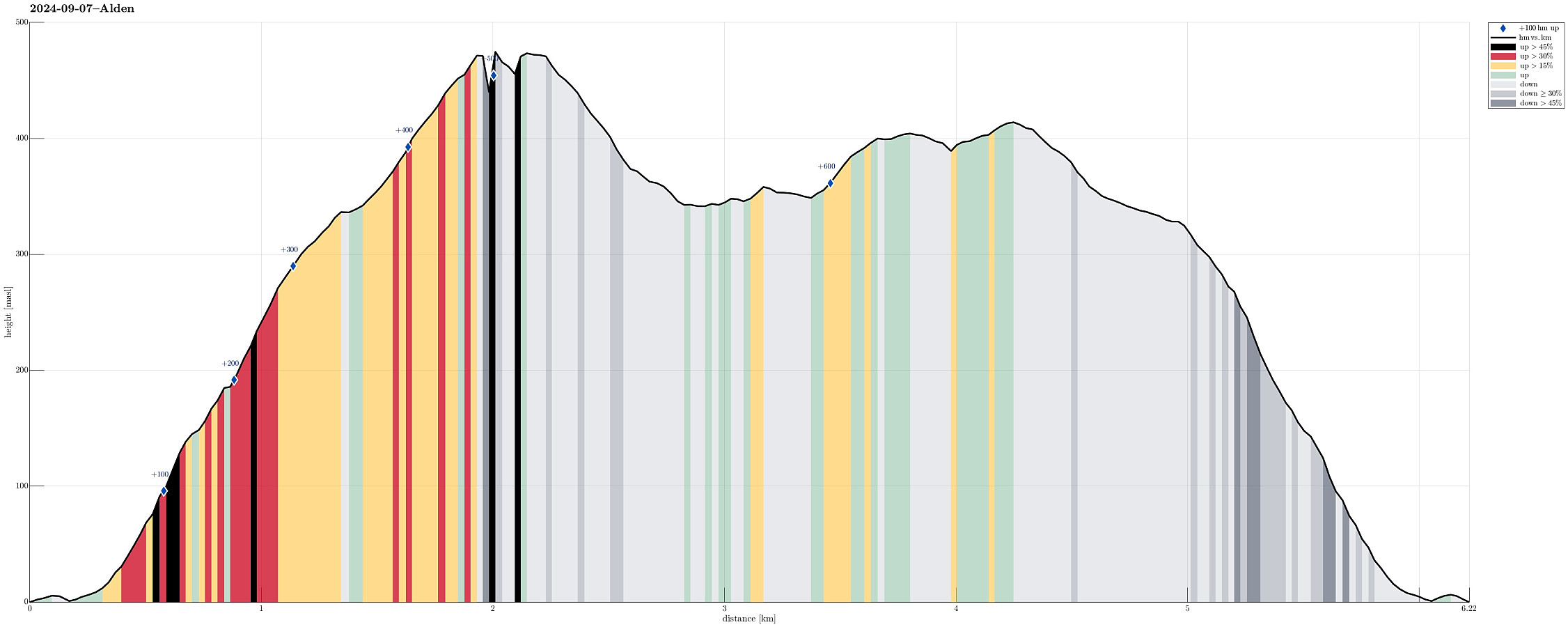 We had stayed on Værøyna over night and then could borrow a small boat to get over to Alden. We "parked" the boat at the main quay in Aldevågen and started our hike from there. Following the one trail that leads up to the top(s) of Alden, we made quick progress -- the terrain is very steep, but the trail is very good and easy to step up. Once up to about 300 masl, we headed towards the hightest peak on Alden, Instenova, in the East of the island. Following the main trail, we could nicely make it to the top without any difficulties. Clearly, one gets lots of great views from the heights on Alden -- very nice! :-) After our visit to Instenova, we then wished to also see "the other top", Ytstenova, on Alden. To get there, we crossed over the heights, passing by the >>>
Short visit to Hendanes Fyret
- Date:
- 10.07.2023
- Characteristic:
- Walk
- Duration:
- 1:00h
- Distance:
- 1.4km
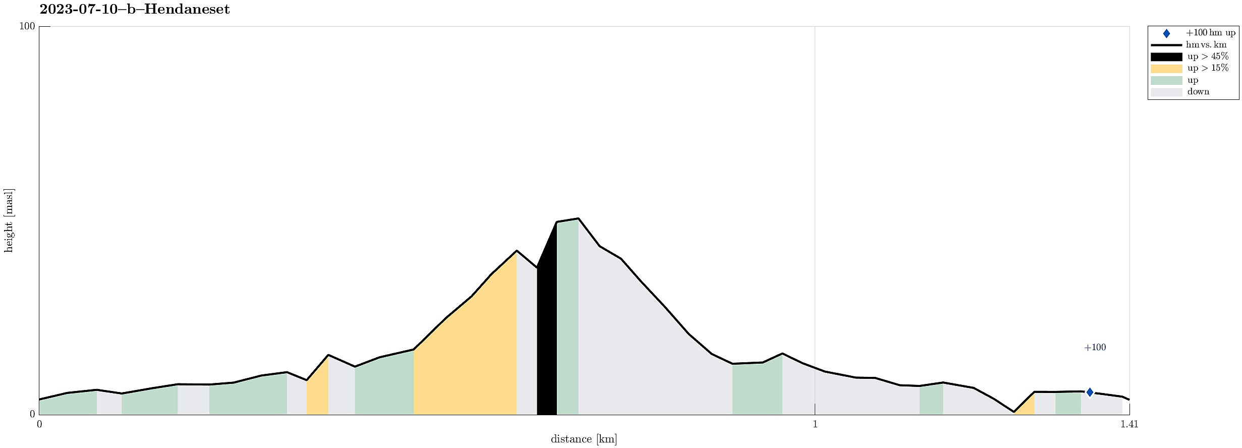 After visiting Kannesteinen , we also wished to see the other side of Torskangerpollen and walking out to the small light house at Hendanes seemed to be a good idea. :-) The path out there is in fact nicely prepared so that this very much is an easy and full uncomplicated walk. Once out at Hendaneset, we enjoyed some great views, not only across Torskangerpollen, but also across Kvalheimsvika to Ytre Kvalheim as well as into the opposite direction (towards Klovningen). Nice walk! :-)
Selected photos are available as Google photo album .
See also the related FB-page Hiking around Bergen, Norway .
After visiting Kannesteinen , we also wished to see the other side of Torskangerpollen and walking out to the small light house at Hendanes seemed to be a good idea. :-) The path out there is in fact nicely prepared so that this very much is an easy and full uncomplicated walk. Once out at Hendaneset, we enjoyed some great views, not only across Torskangerpollen, but also across Kvalheimsvika to Ytre Kvalheim as well as into the opposite direction (towards Klovningen). Nice walk! :-)
Selected photos are available as Google photo album .
See also the related FB-page Hiking around Bergen, Norway .
Havreneset and Nordnes in Florø
- Date:
- 09.07.2023
- Characteristic:
- Walk
- Duration:
- 1:30h
- Distance:
- 3.8km
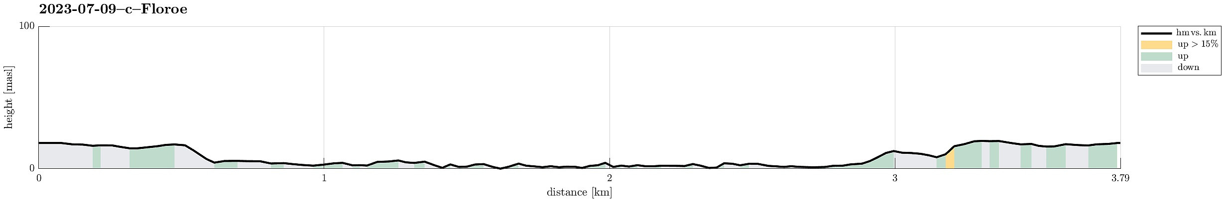 After arriving relatively late in Florø, we still wished to get a bit of fresh air. We also liked the idea to visit Nordnes in the northwest of Florø and so we just went onto a short but nice stroll. First, we visited Havreneset, where quite a bit of installation of an (old) radio station (Florø Radio, discontinued after 2018) is still to be seen. We then stepped along the coast to Nordnes and the marina in Håvågen there. Always nice to smell a bit of ocean air; especially after a long drive! :-)
See also the related FB-page Hiking around Bergen, Norway .
After arriving relatively late in Florø, we still wished to get a bit of fresh air. We also liked the idea to visit Nordnes in the northwest of Florø and so we just went onto a short but nice stroll. First, we visited Havreneset, where quite a bit of installation of an (old) radio station (Florø Radio, discontinued after 2018) is still to be seen. We then stepped along the coast to Nordnes and the marina in Håvågen there. Always nice to smell a bit of ocean air; especially after a long drive! :-)
See also the related FB-page Hiking around Bergen, Norway .
Nice evening hike on Batalden
- Date:
- 27.07.2022
- Characteristic:
- Hike
- Duration:
- 3:00h
- Distance:
- 5.8km
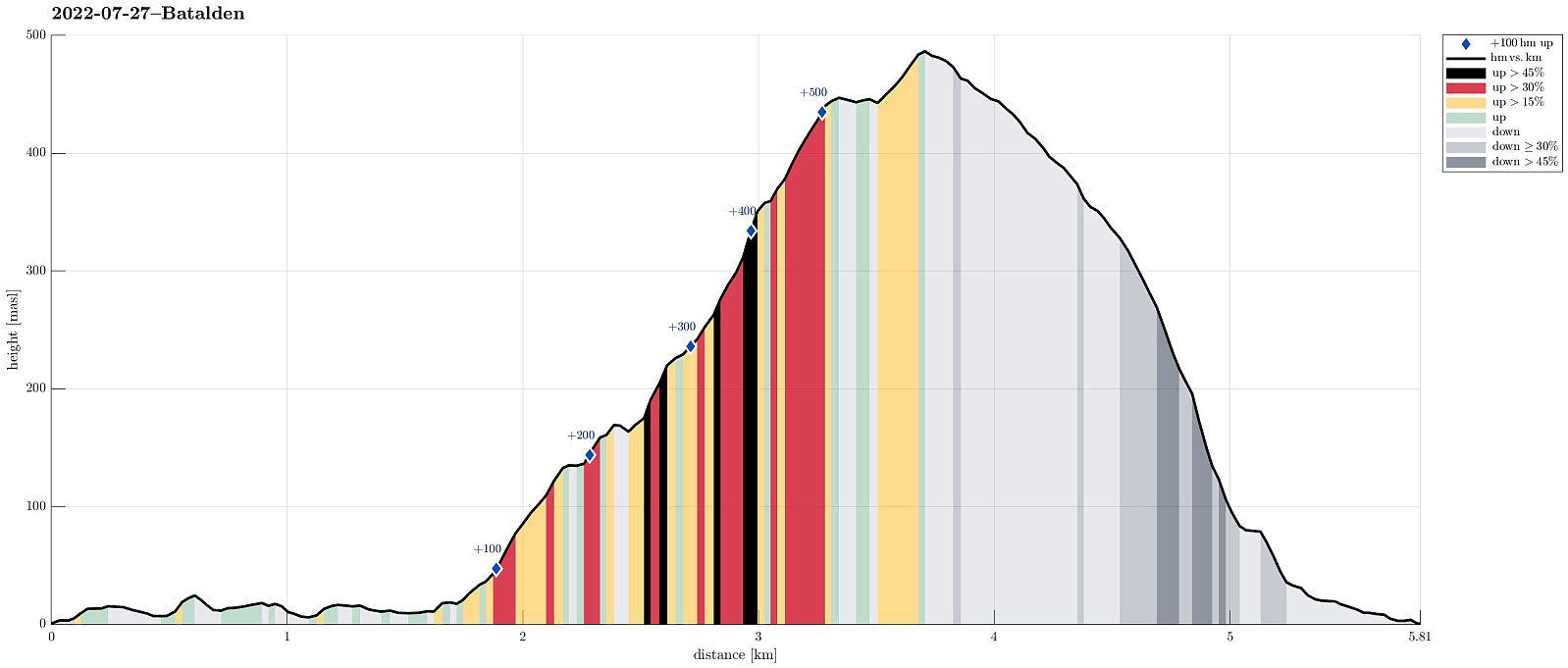 We had taken the car from Bergen to Florø with the plan to enjoy the evening on island Batalden in the northwest of the town. The last two ferries that would stop on the island had a spacing of roughly four hours between them, providing sufficient time for a nice, extended hike. Note that it's important to call the ferries up-front in order to arrange that they actually stop at Batalden. After drop off in the southeast of the island, we started our hike first in northern direction (along the eastern shore of Batalden) to make our hike a nice round (not just up and down the same trail). While it did not really look like a trail (along the shore), we still had the clear impression that at least sheep seemed to use this "trail" and following in their "steps" was quite >>>
Blægja
- Date:
- 29.07.2019
- Characteristic:
- Hike
- Duration:
- 7:00h
- Distance:
- 10.1km
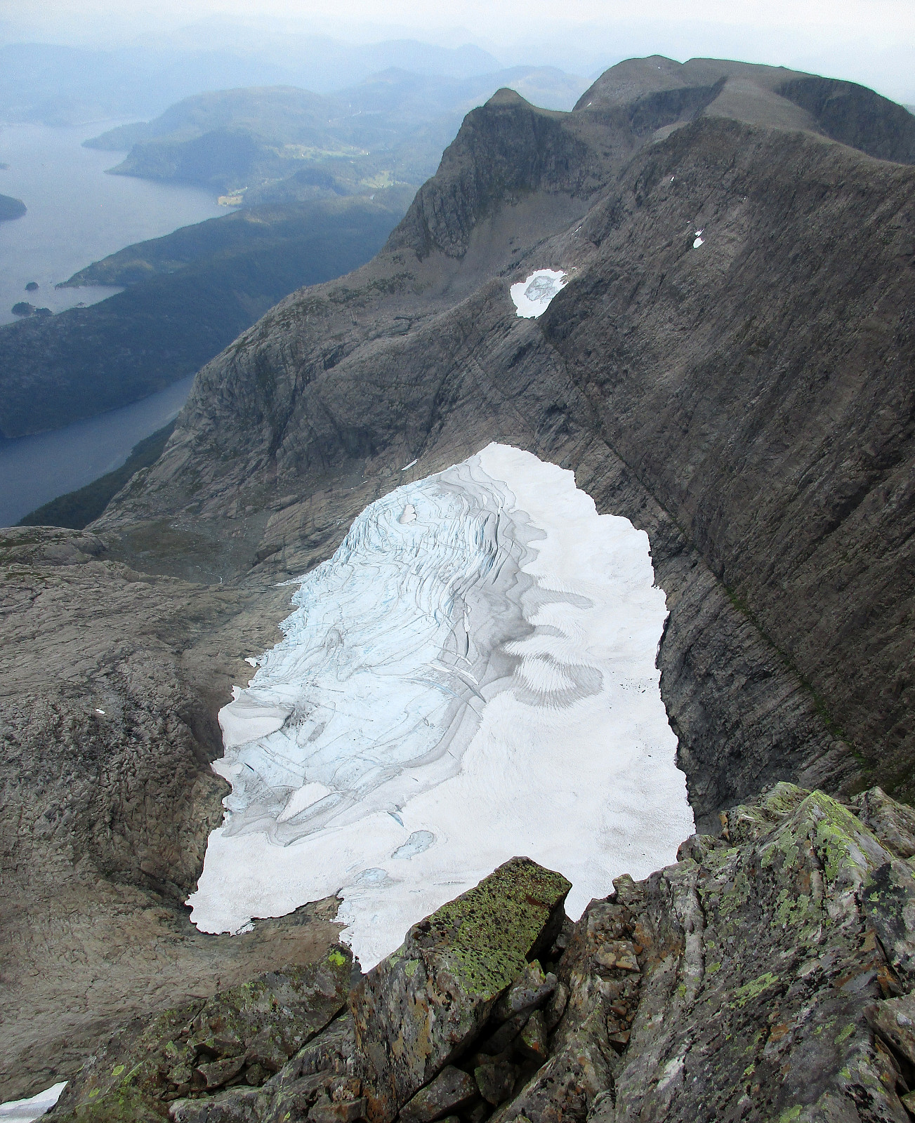 After day #5 of our five days hike through Breheimen , we decided to a "bonus hike". After driving mostly westwards from Breheimen, we stayed in Førde for the night (our goal was to hike up Blægja the next day). The next morning, after driving further westwards from Førde, following road #609 along the southern coast of Førdefjorden, we parked between Hestvika and Rørvika near an information board, right next to the road. After walking down the road for a short stretch, we easily found the trail-head, leading southwards from the road. After first following a forest road for a short distance, the trail leaves to the right and into the forest (once you find it, it's then easy to follow). The path leads upwards, through the forest, staying on the eastern side of a valley, where water from Nipevatnet and Tobbedalsvatnet >>>
