Archiv - Nach Datum
Archiv - Nach Aktivität
-
Andere Tour (1)
- Kayaking (1)
-
Andere Wintertour (4)
- Schneeschuhtour (4)
-
Fahrradtour (137)
- Fahrradtour Straße (9)
- Fahrradtour gemischt (51)
-
Fußtour (740)
- Bergtour (363)
- Jogging (18)
- Spaziergang (89)
- Wanderung (270)
-
Skitour (4)
- Tourenskilauf (4)
Archiv - Nach Geografie
Peakbookfreunde


Gesammelte Listen
-
Bergen ≥ 50m pf. og ≥ 100 m.o.h.
(87/89)
 97%
97% -
Most dominating tops of the Bergen peninsula
(68/75)
90%
-
Utvalgte topper og turmål i Bergen
(316/350)
90%
-
Alle topper i Bergen
(357/398)
89%
-
Opptur Bergen
(100/113)
88%
-
De syv fjell rundt Bergen
(6/7)
85%
-
Sund ≥ 50m pf.
(14/18)
77%
-
Os ≥ 50m pf.
(25/34)
73%
-
Søyler (fastmerker) i Bergen
(68/100)
68%
-
Fjell ≥ 50m pf.
(21/32)
65%

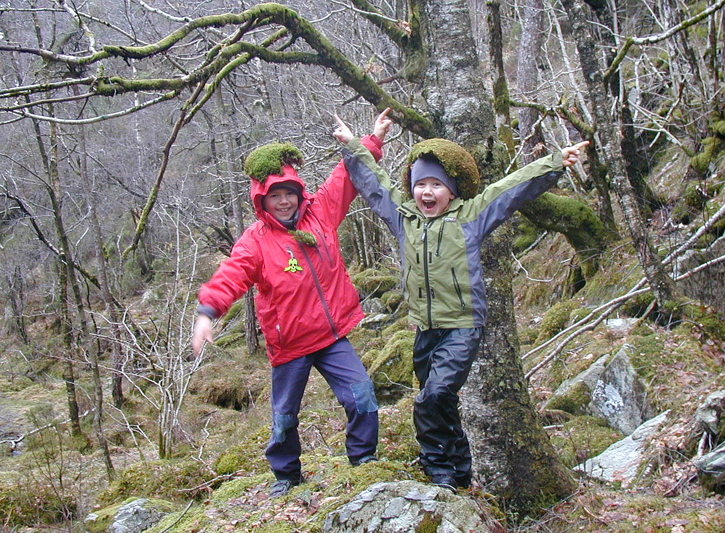
Via Gråfjellet towards Sveningen
- Datum:
- 05.10.2014
- Tourcharakter:
- Bergtour
- Tourlänge:
- 6:30h
- Entfernung:
- 18,1km
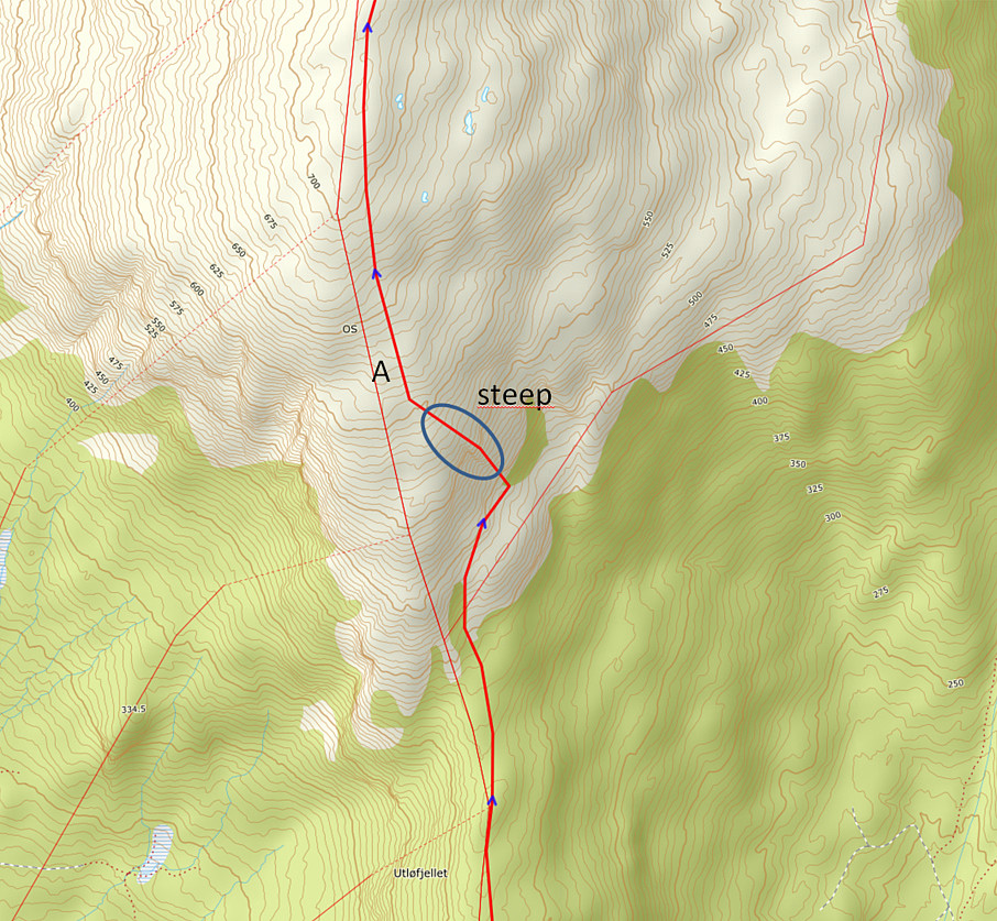 We parked the car in Løyningdalen, right next to the street into Øvredalen. We then crossed the river (bridge) and continued into Stordalen. Following Stordalen, we passed by Gråfjellet and climbed up to Midtfjellet first. From there, we changed over to Gråfjellet, going a bit back in direction. From Gråfjellet, we then descended to Leina and followed the ridge in direction Baggeskaret. Most of this is without any path and you better have a bit of an adventure-spirit to try this connection. From there we continued along the ridge, first via Selsfjellet and then to Utløfjellet, before we started a quite steep ascent towards Sveningen. Basically, most of this tour was along the border between Os and Samnanger. See the image for the part of the trip which was (too?) steep. Maybe, >>>
Raudlifjellet
- Datum:
- 16.08.2014
- Tourcharakter:
- Bergtour
- Tourlänge:
- 3:00h
- Entfernung:
- 8,8km
 Nice small tour up Raudlifjellet (via Nordhordlandskulten) from Tømmernes -- the path is not easy to find at once, but once one has found it (also not difficult), it's nice and easy to the top(s). Some nice views towards Kalandsvatnet and towards Os.
Web page WestCoastPeaks.com provides useful information about Raudlifjellet
and also Petter Bjørstad has a useful page about Raudlifjellet (Sælefjellet) .
Nice small tour up Raudlifjellet (via Nordhordlandskulten) from Tømmernes -- the path is not easy to find at once, but once one has found it (also not difficult), it's nice and easy to the top(s). Some nice views towards Kalandsvatnet and towards Os.
Web page WestCoastPeaks.com provides useful information about Raudlifjellet
and also Petter Bjørstad has a useful page about Raudlifjellet (Sælefjellet) .
Sveningen
- Datum:
- 27.04.2014
- Tourcharakter:
- Bergtour
- Tourlänge:
- 3:00h
- Entfernung:
- 13,1km
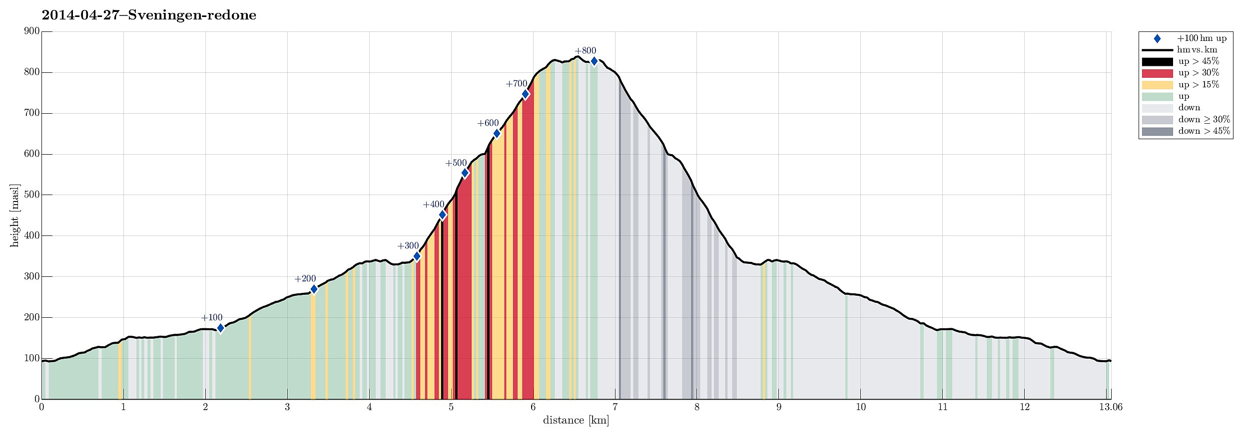 This time, we took a new route to the top: from Brekkjedalen -- that's actually very attractive and rewarding!
Web page WestCoastPeaks.com provides useful information about Sveningen, Søtefjellet, Sauskolten, Rindafjellet, and Midtsæterfjellet
and also Petter Bjørstad has a useful page about Sveningen .
This time, we took a new route to the top: from Brekkjedalen -- that's actually very attractive and rewarding!
Web page WestCoastPeaks.com provides useful information about Sveningen, Søtefjellet, Sauskolten, Rindafjellet, and Midtsæterfjellet
and also Petter Bjørstad has a useful page about Sveningen .
Rødsfjellet
- Datum:
- 04.11.2012
- Tourcharakter:
- Bergtour
- Tourlänge:
- 1:30h
- Entfernung:
- 6,6km
 Nice quick hike (from Gjemdal) on a path which obviously is not used all too often!
Web page WestCoastPeaks.com provides useful information about Rødsfjellet
and also Petter Bjørstad has a useful page about Rødsfjellet .
Nice quick hike (from Gjemdal) on a path which obviously is not used all too often!
Web page WestCoastPeaks.com provides useful information about Rødsfjellet
and also Petter Bjørstad has a useful page about Rødsfjellet .
South-of-Bergen cycling with Endre
- Datum:
- 17.08.2011
- Tourcharakter:
- Fahrradtour
- Tourlänge:
- 4:00h
- Entfernung:
- 74,5km
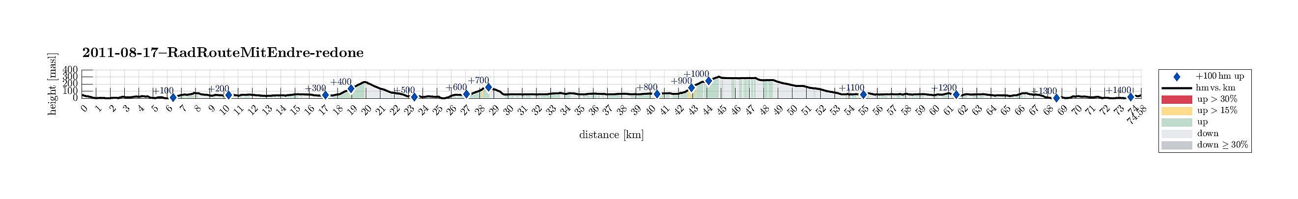 Longer biking round, south of Bergen, with some steeper ascents, not at the least up to Bontveit. :-)
Sveningen
- Datum:
- 10.10.2010
- Tourcharakter:
- Bergtour
- Tourlänge:
- 4:00h
- Entfernung:
- 11,5km
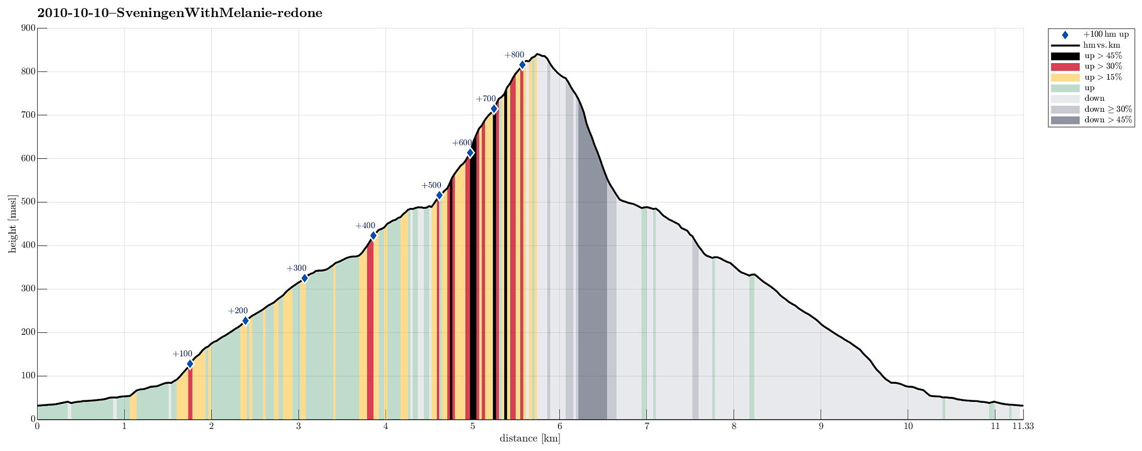 Nice autumn hike up to and down from Sveningen!
Selected photos are available as Google photo album .
Web page WestCoastPeaks.com provides useful information about Sveningen, Søtefjellet, Sauskolten, Rindafjellet, and Midtsæterfjellet
and also Petter Bjørstad has a useful page about Sveningen .
Nice autumn hike up to and down from Sveningen!
Selected photos are available as Google photo album .
Web page WestCoastPeaks.com provides useful information about Sveningen, Søtefjellet, Sauskolten, Rindafjellet, and Midtsæterfjellet
and also Petter Bjørstad has a useful page about Sveningen .
Ulvenfjellet
- Datum:
- 15.03.2009
- Tourcharakter:
- Bergtour
- Tourlänge:
- 2:00h
- Entfernung:
- 4,2km
 A pretty wild tour up and down Ulvenfjellet.
Ottanosi
- Datum:
- 04.10.2008
- Tourcharakter:
- Bergtour
- Tourlänge:
- 3:00h
- Entfernung:
- 9,8km
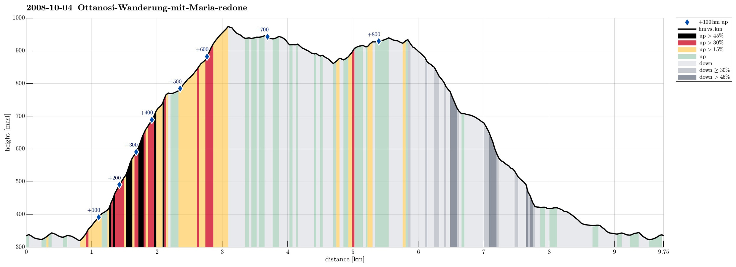 Very nice autumn hike up and down Ottanosi.
