Archiv - Nach Datum
Archiv - Nach Aktivität
-
Andere Tour (1)
- Kayaking (1)
-
Andere Wintertour (4)
- Schneeschuhtour (4)
-
Fahrradtour (137)
- Fahrradtour Straße (9)
- Fahrradtour gemischt (51)
-
Fußtour (740)
- Bergtour (363)
- Jogging (18)
- Spaziergang (89)
- Wanderung (270)
-
Skitour (4)
- Tourenskilauf (4)
Archiv - Nach Geografie
Peakbookfreunde


Gesammelte Listen
-
Bergen ≥ 50m pf. og ≥ 100 m.o.h.
(87/89)
 97%
97% -
Most dominating tops of the Bergen peninsula
(68/75)
90%
-
Utvalgte topper og turmål i Bergen
(316/350)
90%
-
Alle topper i Bergen
(357/398)
89%
-
Opptur Bergen
(100/113)
88%
-
De syv fjell rundt Bergen
(6/7)
85%
-
Sund ≥ 50m pf.
(14/18)
77%
-
Os ≥ 50m pf.
(25/34)
73%
-
Søyler (fastmerker) i Bergen
(68/100)
68%
-
Fjell ≥ 50m pf.
(21/32)
65%

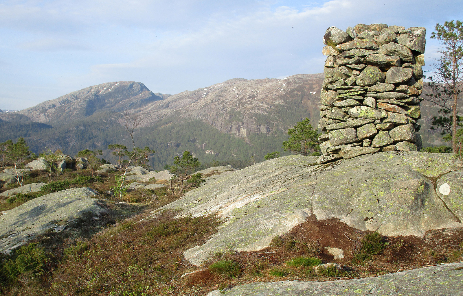
Møsnuken from Tyssdalen
- Datum:
- 13.11.2021
- Tourcharakter:
- Wanderung
- Tourlänge:
- 4:30h
- Entfernung:
- 9,7km
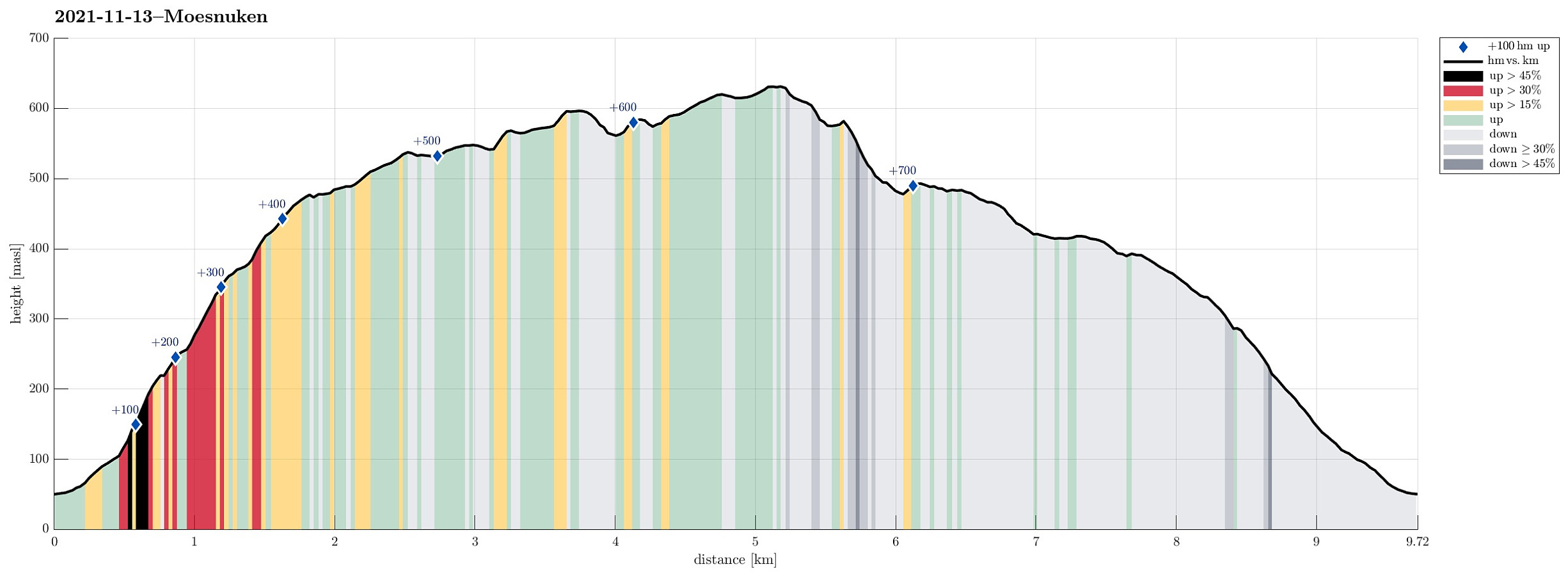 As a small group of four, we wished to some nice autumn hiking in quite fine weather. To also enjoy some views across the nice fjord-landscape around Bergen, we decided to make "the standard hike" up to Møsnuken. Taking E39 south from Bergen, we soon passed by Kalandsvatnet and then Syfteland. A little further south, just before the roundabout at Ulven, we turned left and onto Tøsdalsvegen. In the south of Tyssdalsvatnet, we crossed over a small bridge and parked soon after at the parking spot for hikers right next to Tyssdalselva. Starting our hike on the main trail towards Møsnuken, we crossed Tyssdalselva after just a few meters. Then, after just following the main trail for a few further meters, we turned left to do the ascent to Møsnuken via Linken. This (also very >>>
Eggene (and back via Raudlifjellet)
- Datum:
- 19.09.2021
- Tourcharakter:
- Wanderung
- Tourlänge:
- 3:00h
- Entfernung:
- 6,9km
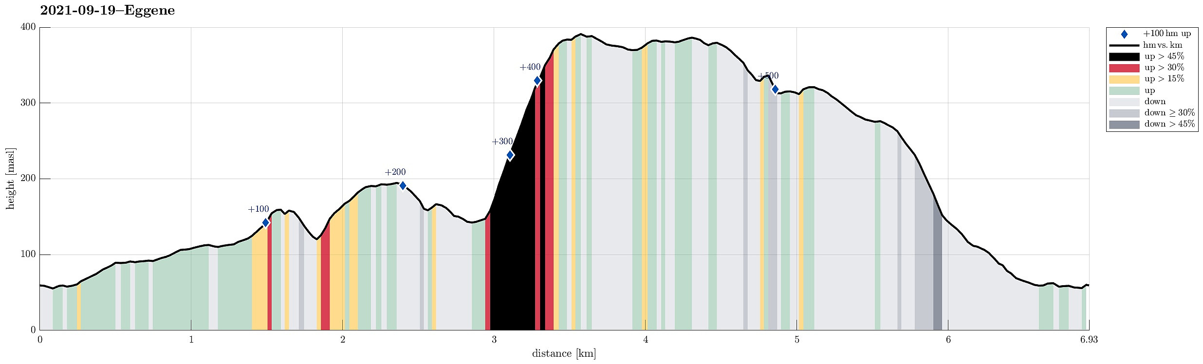 With most of the day overcast, the day's goal was an excursion into the forest in the southeast of Hausdalen. We drove first along E39 into the south of Bergen, parking not far from this road near Bahus. From there, we first walked along the road, crossing Straumen on the road's bridge, before quickly finding a tractor road that would lead us behind the houses (in northeastern direction, towards Storerinden). Once past the houses, we also left the tractor road, ascending to the gentle ridge (Storerinden). Once on the ridge, it was then straight-forward and easy to follow it (in northeastern direction). This way, one gets directly to Høghaugen (in the northwest of Breidalen) with some first nice views into Hausdalen (and down to Hauglandsvatnet). To connect further to Eggene, one needs >>>
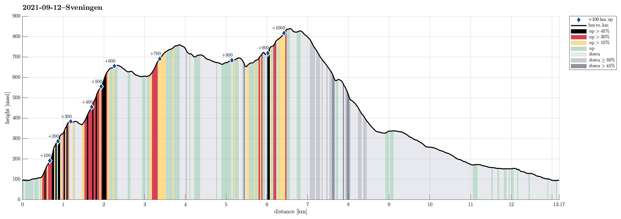
Sveningen via Åsen from Brekkedalen
- Datum:
- 12.09.2021
- Tourcharakter:
- Wanderung
- Tourlänge:
- 6:30h
- Entfernung:
- 13,2km
 The weather forecast has been promising (very promising), even in the morning, so what could go wrong? :-)
Considering the expected day full of sunshine and pleasant hiking temperatures, we aimed at something slightly "bigger" and since we had not visited Sveningen recently, we planned a nice hike over this mountain! To make this a bit more interesting, we decided to include an ascent that we had not tried before (and of which we also could not find any other report from others), i.e., up to Åsen, first, from the north, and then over the northernmost part of the Sveningen massif (in eastwards direction, kind of "parallel" to Brekkedalen in the north of it). To get started, we drove into Hausdalen (from E39, south of Bergen) and all the way into it (until the parking >>>
The weather forecast has been promising (very promising), even in the morning, so what could go wrong? :-)
Considering the expected day full of sunshine and pleasant hiking temperatures, we aimed at something slightly "bigger" and since we had not visited Sveningen recently, we planned a nice hike over this mountain! To make this a bit more interesting, we decided to include an ascent that we had not tried before (and of which we also could not find any other report from others), i.e., up to Åsen, first, from the north, and then over the northernmost part of the Sveningen massif (in eastwards direction, kind of "parallel" to Brekkedalen in the north of it). To get started, we drove into Hausdalen (from E39, south of Bergen) and all the way into it (until the parking >>>
Søtefjellet from Hausdalen via Åsen
- Datum:
- 06.06.2021
- Tourcharakter:
- Wanderung
- Tourlänge:
- 5:30h
- Entfernung:
- 11,3km
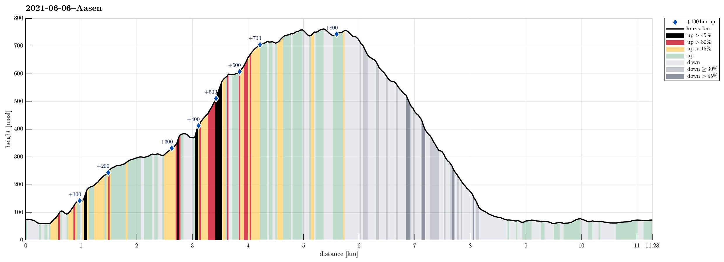 With the promise of a nice afternoon ahead of us and knowing the days are long during the Norwegian summer, we headed for Hausdalen and a hike that we had thought about for quite a while (it had to wait for the right day!). The main idea was to start in Samdalen (a long way into Hausdalen) and then hike to Åsen first (a kind of smallish hill that nonetheless peaks out from its exposed position at the junction of Hausdalen and Brekkjedalen). From there, the idea was to attempt an ascent to Søtefjellet, from where we knew that it was straight-forward to hike down along the long ridge that leads in southwestern direction towards Ulvvatnet. After driving into Hausdalen from the very south of Kalandsvatnet (along E39 in the south of Bergen), we found a suitable place right next to the road, >>>
Tåkenuten and Kråkenos
- Datum:
- 23.05.2020
- Tourcharakter:
- Wanderung
- Tourlänge:
- 6:15h
- Entfernung:
- 13,4km
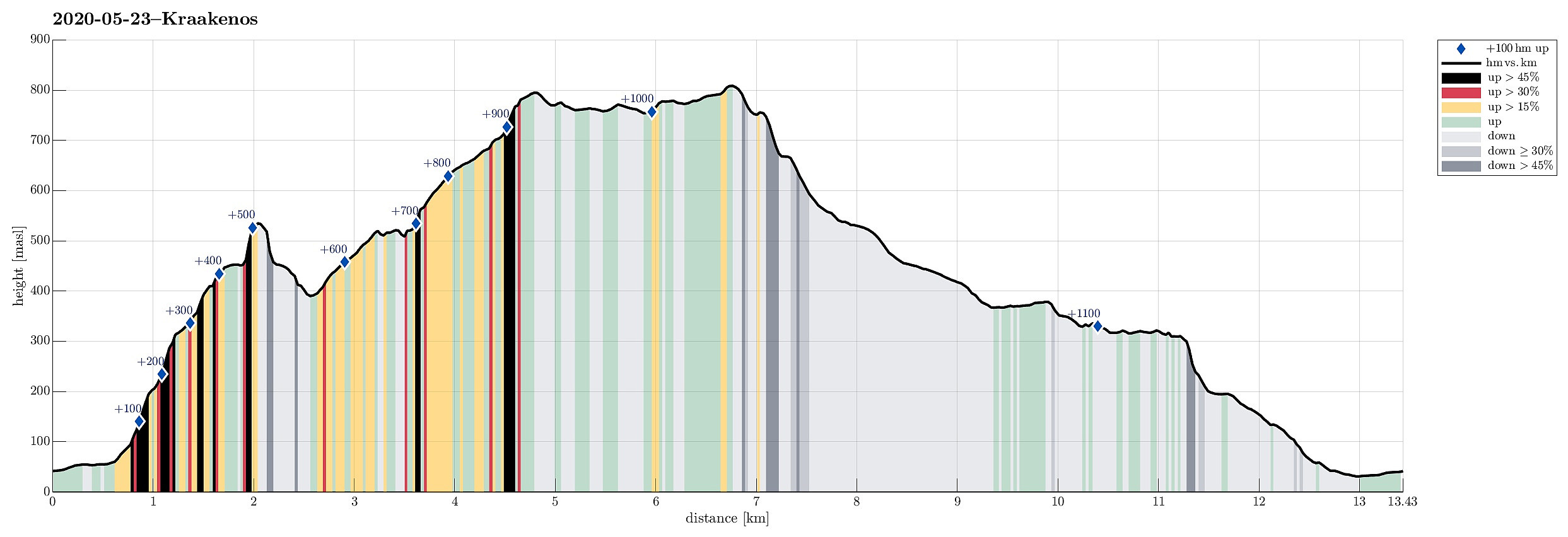 Weighing the weather forecast with our wish to make a nice hike, we ended up with Kråkenos as our hiking goal. While this mountain is also well accessible from its eastern side (from Bru near Strandebarm at Hardangerfjorden), we decided to approach it from its western side, i.e., from Øvre Hålandsdalen. To get there, we drove from Bergen first along E16 into the direction of Voss, then along road 49 into the direction of Kvamskogen, before then continuing along road 48 to Eikelandsosen and from there further towards Holdhus a few kilometers in the east of Eikelandsosen. Near Holdhus one needs to take a sharp turn to the left (north) onto an old and narrow road that leads into Øvre Hålandsdalen (after first passing between Gjønavatnet in the north and Skogseidvatnet in the south). >>>
Lyshornet from Bahus via Blåheiane
- Datum:
- 26.12.2019
- Tourcharakter:
- Bergtour
- Tourlänge:
- 2:00h
- Entfernung:
- 7,5km
 For some time, we had discussed a hike via Blåheiane to Lyshornet from Osvegen. After earlier having rejected this idea several times, this day seemed to be right for trying this idea! :-) We took the car to E39, passing by Kalandsvatnet, and parkd near Fortunet/Bahus. We first walked along the street southwards for a short stretch, before then turning right (and upwards) near house 623 on the opposite side of Vedavika. After having walked passed the house and a gravel place on our right, we turned left (and steeply upwards) at about 75mosl in order to shift over to yet another valley (one further to the south). This brought us to another gravel road at about 100mosl, leading southwards along the hillside, with some nice views over Røyknesvatnet in the east (and further into the direction >>>
Møsnuken from Gåssand
- Datum:
- 05.10.2019
- Tourcharakter:
- Wanderung
- Tourlänge:
- 5:00h
- Entfernung:
- 12,5km
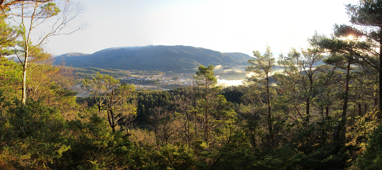
 Møsnuken is very much worth a visit, not only for those who live in or around Osøyro. Usually, one would approach Møsnuken from the west (via Tyssdalen), or via Borgafjellet from Os. Less common is the approach from the north, i.e., from Gåssand. Some longer time back, we already tried this once, but failed (we had ended up at the northern side of Krokavatnet and did not see any reasonable way to get over it). So we decided to give this adventure another try! :-) Taking E39 southwards from Bergen, we turned left in Søfteland (where there's a sign towards Gåssand). As soon as one crosses Oselva one continues on the relatively narrow road Gåssandvegen in northeastern direction. After passing through a small valley (Lona) between Raudlifjellet (on the left) and Åsen (on the right), >>>
Drangsfjellet with Høgelikampen
- Datum:
- 31.08.2019
- Tourcharakter:
- Bergtour
- Tourlänge:
- 3:00h
- Entfernung:
- 6,6km
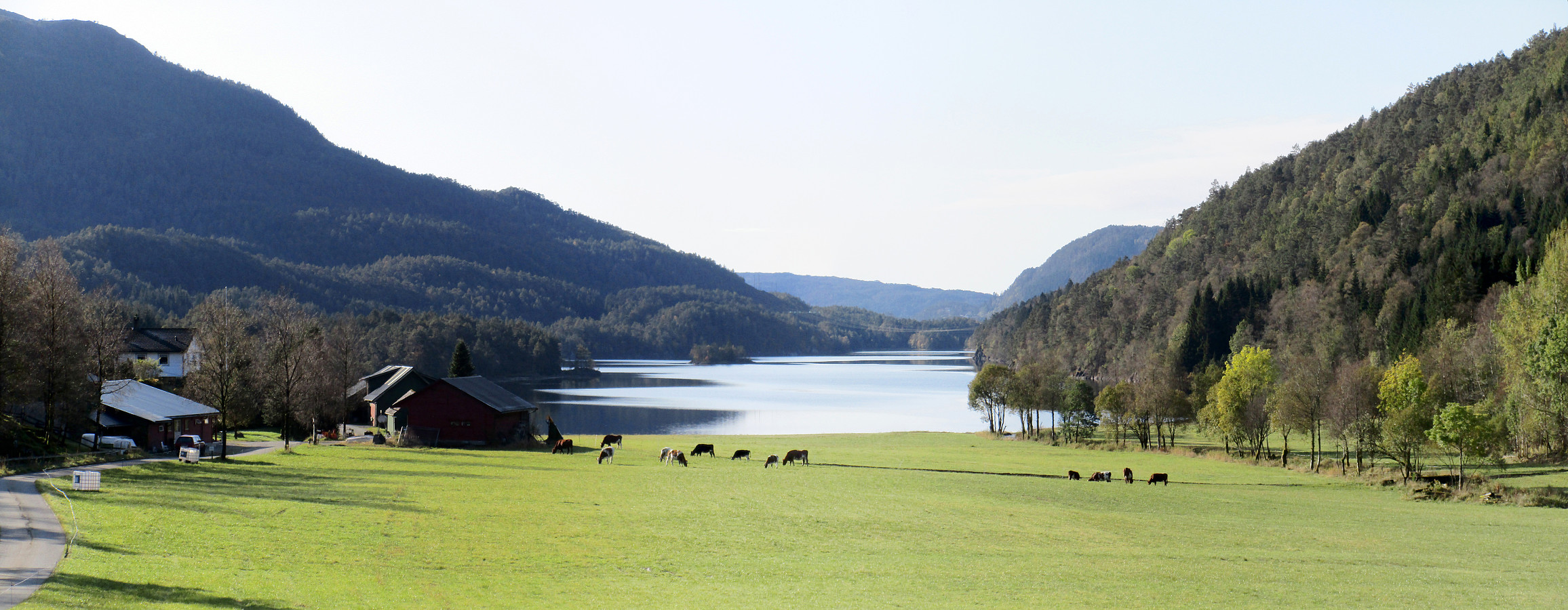
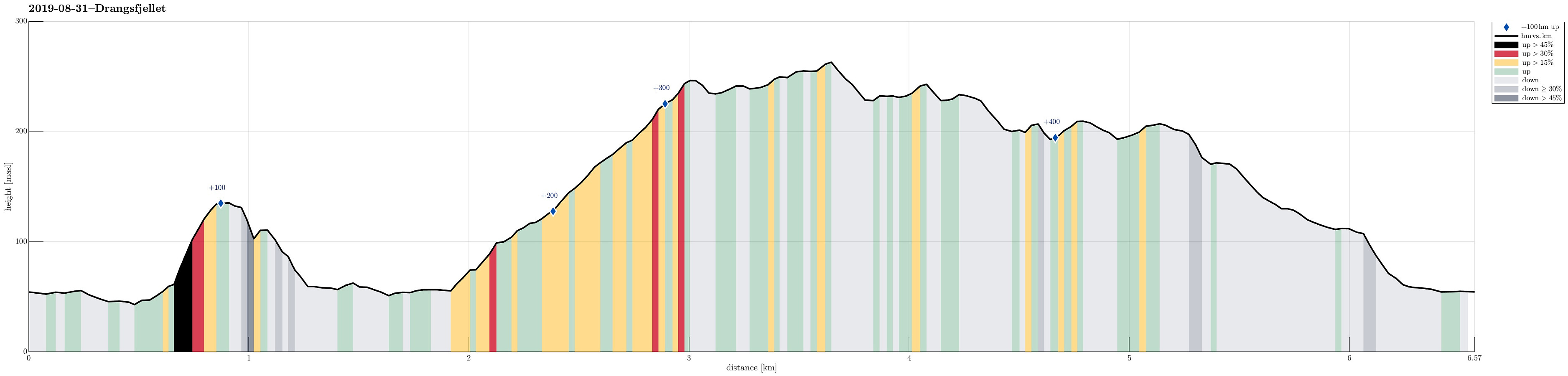 We left Bergen towards the south, passing by Fana and driving over Fanafjellet (road #5158). Near Sørstraumen, where road #5156 leaves to the left (in eastern direction), leading to Lyseklosteret before continuing towards Ulven, we turned right, following along the coast of Seiasundet. South of Søvik, where the road leads away from the sea, we then took a sharp turn to the right (towards Drange). Before getting to Drange (and just before getting to Langavatnet), we parked the car right next to the road. Instead of starting our hike into the forest from there, however, we first followed the road a bit further (to Indre Drange, actually). There, we found a good place to leave the road and start our first ascent (up to Fjærhovda). While it was not difficult to find our way up there, one >>>
Hjortåsen on Strøno
- Datum:
- 07.07.2019
- Tourcharakter:
- Bergtour
- Tourlänge:
- 2:00h
- Entfernung:
- 4,4km
 We took the car to the south of Bergen, driving then road 160 from Ulven to Strøno. After crossing the narrow bridge to Strøno and driving up just a little to the T-junction, where the streets to Nordstrøno/Sørstrøno split, we turned right (towards Nordstrøno). Only a couple of meters before getting close to the first houses on the north-side of the island, we stopped next to the road and started hiking, following a simple forest road that starts from the street there in southwestern direction. At about 80mosl, where the forest road ends, we then continued on a well-visible path (further up in southern direction). At about 140mosl, we spotted Såta nearby (in northeastern direction) and thought that we may have a nice view from up there. It took only a few minutes to get over (no >>>
Skarsnuten, Vardafjellet, Grytefjellet, and Belgjaråsen
- Datum:
- 30.04.2019
- Tourcharakter:
- Bergtour
- Tourlänge:
- 5:45h
- Entfernung:
- 14,8km
 After a meeting at Solstrand Bad & Hotel, we decided to do a hike in nearby Fuse before heading back to Bergen. From Hattvik, we thus took the ferry over to Venjaneset and drove from there further along road 552 towards Eikelandsosen. There we took to the left (onto road 48 and into the direction of Samnanger) and continued on it for a few kilometers (until we had come through Moshovdatunnelen). Right after the tunnel, we turned right (onto Hafskorvegen) and parked soon after (very near to the bridge that we had just passed over after the tunnel).
Our first hiking goal was Skarsnuten, a little top "in the valley", south of Hafskorvatnet. It was nice that we could see the top from the very start of the hike, also. We first followed the little road that leads up to Hafskorvatnet, >>>
After a meeting at Solstrand Bad & Hotel, we decided to do a hike in nearby Fuse before heading back to Bergen. From Hattvik, we thus took the ferry over to Venjaneset and drove from there further along road 552 towards Eikelandsosen. There we took to the left (onto road 48 and into the direction of Samnanger) and continued on it for a few kilometers (until we had come through Moshovdatunnelen). Right after the tunnel, we turned right (onto Hafskorvegen) and parked soon after (very near to the bridge that we had just passed over after the tunnel).
Our first hiking goal was Skarsnuten, a little top "in the valley", south of Hafskorvatnet. It was nice that we could see the top from the very start of the hike, also. We first followed the little road that leads up to Hafskorvatnet, >>>
